It was once believed that only thanks to the Divine Consort – the Queen, the royal power could rest in the hands of the king – her husband (Żylińska 1972-1986:56; see: Noble 2003:79-84). It was also a remnant of matriarchal times that Pharaohs shaved their beard to resemble their feminine consorts; when the king-warrior replaced the divine Queen in the performance of sacred rites, he put on women’s dresses and had his face close shaved (Ibid.:56). At a time when in Egypt the Pharaohs were fully in power, in accordance with the old tradition, they still close shaved, but to emphasize their masculinity – because the patriarchal time had already come – they additionally wore an artificial beard, together with their coronation garments (Ibid.:56-57).
Royal Wife and goddess by birthright
Menkaura flanked by the goddess Hathor (left) and the goddess Bat (right). Graywacke statue in Cairo Museum. The sculpture shows the concept of the Divine Consort – the Queen who grants the royal power to a male king – her husband. Photo by Chipdawes (2019). Public domain. Colours intensified. Photo and caption source: “Menkaure“ (2020). Wikipedia. The Free Encyclopedia.
Also, Thutmose the First, the third pharaoh of the Eighteenth Dynasty in the times of the New Kingdom, had his face close shaved (Żylińska 1972-1986:57). He became a Pharaoh thanks to his marriage to his half-sister, in whose veins divine blood flowed and whose offspring also had divine origins (Ibid.:57). For no matter who the queen of Egypt was married to, the god Amon-Re was considered the father of her children (Żylińska 1972-1986:57; see Noble 2003:79-84). The child of the Queen Ahmose and the god Amun-Re was a girl (Żylińska 1972-1986:57). She was given the name Hatshepsut. On the other hand, Thutmose the First had also a son with the concubine, whose name was Thutmose as well (Ibid.:57). Those events possibly took place at the turning of the fifteenth century BC.
Mortuary temples in western Thebes
I was just thinking about the life of an extraordinary Egyptian queen. Jadwiga Żylińska (1972-1986:56-70) tells her story like a fairy tale, which, however, really happened.
We had already landed on the west bank of the Nile. In a few minutes we were to reach Deir el-Bahari, a valley near the famous Valley of the Kings (“Deir el-Bahari” 2020). It is a complex of mortuary temples and a part of the Theban Necropolis in the Upper Egypt (Ibid.). The so-called mortuary temples erected in Western Thebes can be divided into two main groups: terraced temples and temples with a classical arrangement (Lipińska 2008: 160; see: Miracle of the Sun). Among the terraced temples, the oldest and largest is the Temple of Queen Hatshepsut (Ibid.:160). It was built under the influence of the construction of the Mortuary Temple of Nebhepetre Mentuhotep the Second, erected during the reign of the Eleventh Dynasty, which ruled at the end of the third millennium BC. (Ibid.:160). In turn, the temple of Queen Hatshepsut was a model for others, later sepulchral edifices (Ibid.:160).
Djeser-Djeseru – Hatshepsut’s temple, the focal point of the compound. Photo by Dan Lundberg (2011). CC BY-SA 2.0. Colours intensified. Photo and caption source: “Deir el-Bahari” (2020). In: Wikipedia. The Free Encyclopedia.
Surviving for eternity
Our bus was rocking on the way to our next destination, and my mind again went back to the Eighteenth Dynasty and Hatshepsut herself. At that time, the capital of Egypt was in Thebes. After the Hyksos were driven out of the land of the Pharaohs (see: The World Ended When Gods Turned against the Minoans), the city returned to its former glory and grew in splendour with each passing year (Żylińska 1972-1986:57). Hatshepsut often sailed from the east bank of the Nile, where the palace was located, to the West Thebes, where the dead reigned (Ibid.:57-58). She wanted to see if the work on the tomb being erected for her earthly father had already progressed (Ibid.:58). It was the only time when the inhabitants of the commercial district and the port could see the tall, long-legged and motionless-faced Pharaoh’s divine daughter (Ibid.:58).
Seeing the tomb erected by the Chief Royal Architect, Ineni, Hatshepsut thought that a mortuary temple should also be built for herself (Żylińska 1972-1986:58). That one would survive for eternity when there was no more trace of her on earth (Ibid.:58).
My thoughts were interrupted by the whistle of the opening doors of the bus. When we got out of it, a long train with six-seat carriages came to take us to the foot of the Mortuary Temple of Hatshepsut.
Successor of her father
Hatshepsut’s representation in a documentary (screenshot). Source: TV db; Administrator (2019): “16:9 Screencap 60792152 of the documentary Secrets of Egypt’s Lost Queen”, directed by Brando Quilici (2007). In: Discovery Channel Documentaries. TV db.
When Hatshepsut turned twenty-four, Thutmose the First announced her as his successor (Żylińska 1972-1986:58). The celebration took place in Karnak, in the temple of Amun-Re (Ibid.:58). It was followed by her marriage to her sick and weak half-brother, Thutmose the Second, who was seven years old (Ibid.:59). Three years later, Thutmose the First died and the new royal couple began reigning together over a united Egypt (Ibid.:59). Yet, although Hatshepsut was just a Great Royal Wife, it was clear that Egypt was ruled mainly by her (Ibid.:59).
Just after starting her reign over Egypt, the Queen immediately began erecting her mortuary temple in the Nile Valley, on the west side of Thebes (Żylińska 1972-1986:59).
The Alley of Sphinxes
The train slowly coiled like a snake just before the road leading to the Temple. By order of the Queen, it was erected directly opposite the district of Amun-Re, on the eastern side of the Nile (Lipińska 2008:160). The Alley of Sphinxes once led to the sanctuary, each with Hatshepsut’s face (Żylińska 1972-1986:66). Now there is no trace of the Alley, except for one or two partially reconstructed sphinxes … (Dr Andrzej Ćwiek in PAP – Nauka w Polsce, Zdziebłowski 2008).
There is no trace of the Alley in front of the Mortuary Temple, except for one or two partially reconstructed sphinxes. Each was with Hatshepsut’s face. Photo by Dezalb (2018). Colours intensified. Photo source: Free pictures at Pixbay.
‘The alley of sphinxes was about 500 m, or 1000 Egyptian cubits long. Based on the recorded databases, we assume that there were about 70 sphinxes. The alley was 6 meters wide, and the distance between the statues was about 17 m’, explains Dr Andrzej Ćwiek, a member of Polish-Egyptian archaeological and conservation mission (PAP – Nauka w Polsce, Zdziebłowski 2008).
Senenmut
The creator of the funerary complex of Hatshepsut, Senenmut, designed a building on a monumental scale (Lipińska 2008:160). He was Hatshepsut’s favourite and the chief architect of the Queen’s works in Deir el-Bahari (Żylińska 1972-1986:64; Lipińska 2008:160). Senenmut “first enters the historical record as the ‘Steward of the God’s Wife’ (Hatshepsut) and ‘Steward of the King’s Daughter’ (Neferure). […] After Hatshepsut was crowned Pharaoh, Senenmut was given more prestigious titles and became high steward of the king” (“Senenmut” 2020).
TT 353 of Sen-en-Mut (Senenmut tomb) – a hypogeum built by the order of Sen-en-Mut, 97.36m long and 41.93m deep. Photo by Edal Anton Lefterov (2011). CC BY-SA 3.0. Colours intensified. Photo and caption source: “Deir el-Bahari” (2020). In: Wikipedia. The Free Encyclopedia.
Moreover, some of archaeological evidence supports the idea that he had an emotional connection with the Queen and there was an intimate relationship between them (Quilici 2007). One of the traces supporting this hypothesis is definitely Senenmut tomb, placed just beneath the Hatshepsut’s Mortuary Temple, and ambiguous representations and writings inside it (Ibid.). Although Senenmut was the government official, he was just of low commoner birth, and so such a relation with the Queen-Pharaoh, who was perceived as an incarnation of gods on earth would be outrageous to the public at that time (Ibid.). Still, there is no decisive evidence that such an affair took place at all (Ibid.).
Prosperity of Egypt in stone
When we were standing in front of the Temple, before our eyes a high sand cliff rose. At its foot, the irregular and jagged shapes of rocks turned into a geometric arrangement of ramps, successive terraces and porticoes, rising and climbing upwards. The temple, although largely reconstructed by archaeologists, is remarkable and still arouses admiration among visitors; It was built of local white limestone beautifully harmonizing with the natural colour of the rocks, and its well-balanced porticoes are supported either on pillars or on polygonal columns of several types (Lipińska 2008:164). A real feast for the eyes!
From the entrance to the courtyard to the main sanctuary in the heart of the complex is 240 meters in a straight line, and the width of the central courtyard exceeds 100 meters (Lipińska 2008:161). The difference in levels between the lower courtyard and the highest storey of the temple is over 15 meters (Ibid.:161). According to the classical temple plan, the temple complex began with the lower temple, also built on terraces, almost completely ruined today (Ibid.:161). A one kilometre long avenue led to it, guarded once by the mentioned sphinxes (Lipińska 2008:161; Żylińska 1972-1986:66). The main temple had no pylons, only a stone gate in a wall of white limestone surrounding the courtyard (Lipińska 2008:161). The entire structure is situated on three successive levels: the lowest one is a courtyard closed on the west side with porticoes, between which a sloping ramp leads to the middle level (Ibid.:161). The northern portico has a badly damaged decoration depicting hunting and fishing, and the southern portico shows a unique scene of the transport of two obelisks ordered by the Queen in Aswan, and floated by a large barge to Thebes (Ibid.:161). One of these obelisks still stands in the Temple of Karnak (Ibid.:161).
‘The Queen also donated to the expansion of the Temple of Karnak itself,’ recalled Menes, our guide (Lipińska 2008:161; Quilici 2007). There, on a granite obelisk covered with a thick layer of electrum (a mixture of gold and silver), she had the following words inscribed (Żylińska 1972-1986:66; Brier 2017).
“I have thought of what people shall say, [when they see the monuments I have founded]. Don’t say my words are exaggerations but say how like her it is, to be true to her father”.
Time Trips (2021).
At that time, for a daughter to be considered as not worse than a son, she had to be twice as good as him (Żylińska 1972-1986:66).
As the Egyptologist, Kara Cooney, states it is well shown in stone that Hatshepsut brought prosperity to the country (Quilici 2007). Not only did she greatly contribute to the growth of the Temple of Amon-Re in Karnak, but also she actually founded Luxor Temple (Ibid.).
She had brought peace and abundance
The reign of Hatshepsut therefore took place in peace, time spent on daily duties and pleasures of common Egyptians, and the growth of the Queen’s power through the foundation of monumental temples and the establishment of and strengthening trade contacts, including such relations with Caphtor (possibly Crete), and with the legendary land of Punt. It is probably thanks to the Queen’s help that the inhabitants of the Nile Delta, fleeing the effects of the volcanic eruption on Thera, found rescue and refuge in Thebes. Yet, it is unknown if the recorded disaster had been caused by the volcano or if it had happened at all at that time, as Hatshepsut’s reign was rather a period of prosperity (see: The World Ended When Gods Turned against the Minoans).
Years later, people got used to such affluence and common wealth, resulting from long-term peace (Żylińska 1972-1986:60). There was no hunger or thirst in any part of the country, livestock multiplied in abundance, the children of Egyptians were born on the Nile, no one lacked grain, oil, or honey (Ibid.:60). Memories of the Pharaohs’ war expeditions faded into oblivion and slowly, like all past events, became legendary (Ibid.:60). Similar stories were also told to little Thutmose, Thutmose the Second’s son, born of a concubine like his father (Ibid.:61). He listened to similar stories with bated breath and burning face, and in his heart a longing for the glory of war and a thirst for conquest was born (Ibid.:61).
Arranged miracles of Amun-Re
At that time, the priests of Amun-Re in Karnak gained more power and influence, including such matters as the appointment to the throne of Egypt (Lipińska 2008:134). The best example illustrating their dominance happened the case of the son of Thutmose the Second (Ibid.:134). Although Thutmose the Third’s father was the Pharaoh, his mother was not the Great Royal Wife but the lesser lady of the Harem (Ibid.:134). So he had no right to the throne, but he was the only male descendant of the king who died, leaving behind only a legitimate daughter, Neferure (Ibid.:134). At first, the priests of Karnak thought that the boy was more suitable to be a ruler, and ‘arranged’ a miracle; during the procession in the pillared hall of the temple of Amon-Re, the god’s statue stopped in front of the boy hiding in the shadows of the pillars and appointed him as the successor of his deceased father (Ibid.:134).
Thutmose the Third took over the throne but it did not prevent the priests from coronating the widow of Thutmose the Second, Hatshepsut, just a few years later (Lipińska 2008:134). To justify the crowning of Hatshepsut, the priests composed a song about her divine origins, according to which the god Amon-Re himself, taking the form of Thutmose the First, visited his holy wife and conceived the daughter (Ibid.:134). When she was born, the god introduced her to all the gods as the future ruler of Egypt (Ibid.:134). The priests of Amun-Re probably understood the Pharaoh did not have to be a man, especially when the Hyksos were eventually defeated and the country needed peace (Żylińska 1972-1986:59). On the whole, there seems to be a trace in this tangled story of the existence of two factions among the priests of the Temple of Amun in Karnak, one supporting Thutmose the Third and the other, Hatshepsut (Lipińska 2008:134-135).
False beard of the Pharaoh-Queen
Hatshepsut had been crowned the Pharaoh at Karnak (Żylińska 1972-1986:61). During the ceremony, she appeared in a ritual outfit, in a diadem with a uraeus, which has always stood for ‘goddess’ and was strongly linked to royalty in Egypt (Żylińska 1972-1986:61; Noble 2003:83-84). In her hands in turn she held a golden whip and a staff, both crossed on her breast (Żylińska 1972-1986:61). According to the repeated ritual, she had a false beard attached to her face, which actually was a double mystification, but she was not aware of it (Ibid.:61). The patriarchy had already left its mark on people’s minds and there was no turning back to the old values. By attaching a false beard, the woman now imitated the man to be honoured and become the Pharaoh, the female incarnation of Horus (Ibid.:61).
Horus as a falcon in front of the Mortuary Temple, Deir el-Bahri. Photo by Dezalb (2015). Colours intensified. Photo source: Free pictures at Pixbay.
On the same base of the obelisk founded by Hatshepsut, the carving also reads (Brier 2017):
“I erected them for my father Amun. They could be seen from the other side of the Nile, their tips gleaming in electrum” (Brier 2017).
It is true that “Hatshepsut used her obelisks as a form of propaganda[?] [Nevertheless, she had never tried to] pass herself off as a man. She calls herself the female Horus—female falcon—meaning she [was] the king, although she [was] female” (Brier 2017).
But Hatshepsut was also the earthly incarnation of Horus’ divine wife, Hathor. The name Hathor means ‘House of Horus’ which embodies the whole idea of a divine wife giving her husband the right to the crown (Lipińska, Marciniak 2006:161; see Noble 2003:79-84). Hathor – the goddess of beauty and love – was often pictured as a cow or a woman with cow horns on her head, between which a solar disk was placed (Lipińska, Marciniak 2006:161-162; see Noble 2003:79-84). Such attributes not only emphasized her role as the mother feeding her nation (cows have always been extremely valuable in this part of the world), but also the fact that she was of extraordinary beauty.
How’s that? Beautiful? Cow ?’, I once asked my Egyptian guide.
‘Have you seen the cow’s eyes? They are large and deep framed with a veil of long lashes’, explained Menes.
I tried to remember a picture of a cow’s head from my childhood, which I spent in the countryside. There were two good lasses, although I never paid much attention to their ‘wonderful’ eyes.
‘When a man says you look like a cow, it will be the biggest compliment,’ promised the guide.
I smiled. I would like to see the expressions of European women hearing similar compliments.
At first people thought that Hatshepsut, that is to say, Horus and Hathor in one person, would be a regent until her daughter Nefrure grew up and married her half-brother Thutmose in due time, who would be thus granted the throne (Żylińska 1972-1986:61). But it soon became apparent that Hatshepsut did not intend to rule in anybody’s name but her own (Ibid.:61). She herself probably planned to prepare her daughter for the future role of the Pharaoh of Egypt (Ibid.:61). Thutmose, on the other hand, was given military training; he was to become a military commander, maybe even a general, but he was to stay away from Thebes and reigning in Egypt (Ibid.:61). Meantime, his divine stepmother strengthened her power and undertook commercial activities, including a prominent expedition to the Land of Punt.
Offerings from Punt
Punt, a legendary land often associated with today’s Somalia, was apparently beyond the fourth Nile cataract and further than Niya (a kingdom in northern Syria), where the foot of an Egyptian soldier never reached (Żylińska 1972-1986:64; Lipińska 2008:163).
A famous expedition of Hatshepsut to the land of Punt was a successive exploration of that land by Egyptian pharaohs (Żylińska 1972-1986:64-65). At the time of the Fifth Dynasty, there was apparently the very first expedition from Egypt reaching Punt, when Egyptian ships entered its distant ports (Żylińska 1972-1986:64; Irwanto 2019:4). Such far-reaching trade journeys had systematically repeated till the Eighteenth Dynasty (Irwanto 2019:4). But Hatshepsut’s expedition was a commercial journey of an even larger propaganda scale and political significance than earlier journeys in the Fifth, Sixth, Eleventh and Twelfth Dynasties of ancient Egypt (Żylińska 1972-1986:61; Irwanto 2019:4).
Punt, a legendary land often associated with today’s Somalia, was apparently beyond the fourth Nile cataract and further than Niya (a kingdom in northern Syria), where the foot of an Egyptian soldier never reached (Żylińska 1972-1986:64; Lipińska 2008:163).
At the time of Hatshepsut, in addition to the sailors, several court scribes and painters were to accompany the queen so that they could describe the whole expedition and depict it in pictures (Ibid.:64). At the rising Moon, five thirty-oar boats left the Red Sea harbour and headed south (Ibid.:64). The expedition lasted two years and returned to Thebes at the time of harvests with unbelievable treasures (Ibid.:64). The Dukes of Punt mistook the Egyptian expedition for the messengers of heavens and fell on their faces before Hatshepsut (Ibid.:65). The Egyptians prudently held the hostages, and then proceeded to exchange goods: piles of fresh incense, precious myrrh trees, ebony, ivory gold, cinnamon leaves, antimony, baboons, vines, dogs and leopard skins (Ibid.:65). In return, the Queen of Egypt offered them innumerable piles of coloured beads, various fabrics, daggers with decorative handles, painted vessels, two chairs and a multitude of hatchets, both suitable for cutting trees and killing cattle and people (Ibid.:64).
Punt Reliefs, Temple of Hatshepsut at Deir el Bahri. Photo by Zigor Agirrezabala Vitoria (2016). Photo source: Free pictures at Pixbay.
The expedition returning from Punt was welcomed in Thebes with excitement and feverish curiosity, and news of the imported riches and wonders of Punt, the divine land from which the Egyptian goddess Hathor hailed, fired the imaginations of residents of the palace as well as the commercial district (Żylińska 1972-1986:65).
But in this general mood of joy, there was no exultation accompanying the return of the victorious army, that incomparable triumphant intoxication aroused by the soldiers riding on the chariots of war and the long columns of prisoners following them (Żylińska 1972-1986:65). Possibly, similar masculine attitudes of contemporary Egyptians led to the times, when the name of the female Pharaoh, Hatshepsut, was soon to be forgotten.
Featured image: Hatshepsut’s temple. Deir el-Bahari with temples of Hatshepsut, Thutmosis III and Mentuhotep II, Luxor, Egypt. Photo by Ian Lloyd – lloydi.com (2006). CC BY-SA 3.0. Colours intensified. Photo source: “Deir el-Bahari” (2020). In: Wikipedia. The Free Encyclopedia.
By Joanna Faculties of English Philology, History of Art and Archaeology; University of Silesia in Katowice, Poland; Cardinal Stefan Wyszyński University in Warsaw, Poland; University College Dublin, Ireland.
BIBLIOGRAPHY:
“Deir el-Bahari” (2020). In: Wikipedia. The Free Encyclopedia. Available at <http://bit.ly/38ldwbX>. [Accessed on 6th January, 2021].
“Menkaure“ (2020). Wikipedia. The Free Encyclopedia. Available at <http://bit.ly/39cEWA3>. [Accessed on 7th January, 2021].
“Senenmut” (2020). In: Wikipedia. The Free Encyclopedia. Available at <http://bit.ly/35fTkqa>. [Accessed on 6th January, 2021].
Brier B. PhD (2017). “Erecting an Obelisk: A Monument of Egyptian Grandeur”. In: The Great Courses Daily. From the Lectures Series: The History of Ancient Egypt. Available at <http://bit.ly/3hNZwdL>. [Accessed on 6th January, 2021].
Free pictures at Pixbay. Available at <https://bit.ly/2LtkZgc>. [Accessed on 7th January, 2021].
Irwanto D. (2019). Land of Punt: In Search of the Divine Land of the Egyptians. Bogor: Indonesia Hydro Media.
Lipińska J. (2008) Sztuka starożytnego Egiptu. Warszawa: Arkady.
Noble V. (2003). The Double Goddess. Women Sharing Power. Rochester, Vermont: Bear & Compony.
PAP – Nauka w Polsce, Zdziebłowski Sz. (2008) “Rozpoczyna się kolejny sezon badań Polaków w Deir el-Bahari w Egipcie“. In: Nauka w Polsce. Ministerstwo Nauki i Szkolnictwa Wyższego. Available at <http://bit.ly/2Xfyti8>. [Accessed on 7th January, 2021].
Quilici B. (2007). Secrets of Egypt’s Lost Queen. Starring Kara Cooney and Zahi Hawass. Discovery Channel.
Time Trips (2021). “The Inscription on Hatshepsut’s Obelisk”. Based on the translation by Amir Hussein. In: Timetrips.co.uk. Available at <http://bit.ly/2JQb9o9>. [Accessed on 6th January, 2021].
TV db; Administrator (2019). “16:9 Screencap #60792152 of the documentary Secrets of Egypt’s Lost Queen, directed by Brando Quilici (2007). In: Discovery Channel Documentaries. TV db. Available at <http://bit.ly/3hRnTaC>. [Accessed on 7th January, 2021].
Żylińska J. (1972-1986) Kapłanki, Amazonki i Czarownice. Warszawa: Państwowy Instytut Wydawniczy.
We were on the way to Cenote Ik Kil, located in the northern centre of the Yucatán Peninsula and about five minutes (3,2 km) south from Chichén Itzá (“Ik Kil” 2020). Today, it is part of the Ik Kil Archaeological Park and is publicly accessed for swimming and cliff diving (“Ik Kil” 2020; David 2020). Its water level is about 26 metres (85 ft) below ground level; It has got about 60 metres (200 ft) in diameter and is about 48 metres (157 ft) deep (“Ik Kil” 2020).
Swimming in cenotes is always at one’s own risk; there are no lifeguards, and only life vests are available (David 2020). This is why one needs to feel really comfortable swimming out of their depth to enjoy this experience (Ibid.).
Cenote Ik Kil
Around the cenote, there is a well organised tourist infrastructure with two restaurants serving typical Mexican food, changing rooms with lockers and showers, shady areas for relaxing, conveniently placed viewing areas of the cenote, and even cottages for hire to stay overnight (“Ik Kil” 2020; David 2020). To get to a swimming platform with the wooden stairs, there is a carved stone stairway that leads down (“Ik Kil” 2020; David 2020). Still there are three diving platforms beside the pool as well (David 2020). The cenote is open to the sky so visitors are not enclosed, like in cave cenotes, which yet gives another invaluable experience (“Ik Kil” 2020; David 2020). To avoid doing any harm to the cenote ecosystem, the visitors intending to swim must first take a shower to remove all the cream and dirt off of their skin (David 2020). It is not either allowed to touch stones or tree roots around the well (Ibid.).
Luckily, when we got on-site, there were not so many people swimming in the cenote. The water was really fresh, crystal-clear and chilly, which gave a cooling relief from Mexican sunshine (David 2020), even in February. From time to time, I felt tiny fishes nicely nibbling my skin. I swam to the centre of the water circle and I looked up into the open roof section. The view was breathtaking with all those plant strings and tree roots cascading down from the roof edges into the water (Ibid.), and the foliage covering the damp stones of the well just intensified the effect of swimming in the jungle.
Maw of the underworld that holds the underground waters
I dived in to the abyss of the well and I found myself in a completely different world once again. Echoes of people’s voices heard above suddenly fell silent and I felt alone, as if on the threshold to the unknown, underwater realm, existing – as the Maya believed – parallel to the real one (Prager 2013:279).
It was ruled by dangerous deities, such as the rain Mayan god Chaak (Aztec’s Tlaloc), and dwelled by various mythical creatures being the gods’ helpers (Prager 2013:279; Brady 2013:299; Tuszyńska 2007:62-63; “Xibalba” 2020). Some of them personified significant forms of the landscape: mountains, caves and cenotes (Brady 2013:299). In Mayan inscriptions, scholars identify wide-open jaws of Centipede (Sak Baak Chapaata), symbolizing cenotes as the ‘maw of the underworld (or of the Earth Monster) that holds the underground waters’ (Ibid.:299; also see the drawing a: “Maw of the underworld from Pakal’s sarcophagous”. In:Schele and Mathews (1998). Drawing source: Ramos Ponciano M. E., Ball J. W. (2017). Not only cenotes, but also underwater lakes in caves, are the natural models of this mythical place, inhabited by both, animals, such as frogs, lizards, water snakes, scorpions, and more grotesque creatures, like gnomes, souls of the forest and short people, dwarfs (Prager 2013:279).
Divine dwarfs in cenotes
Dwarfs not only performed various administrative functions and entertained the ruler at pre-Columbian royal courts, but also played an important role in the mythology of the Maya, who believed in the classical and post-classical periods that the four dwarfs were tasked with raising the vault of heavens.
Cenote Ik Kil is one of main tourist attractions of Yucatan Peninsula. Photo by Matias Cruz (2014). Photo source: Free images at Pixabay.
The Olmecs also knew of the image of the four dwarfs supporting the sky, where dwarfs were equally pictured, like stone atlases, supporting the structure of the altar, possibly representing the vault of heavens (Prager 2013:278-279). The Maya even saw two dwarfs in the firmament, symbolizing undiscovered constellations (Ibid.:279). Midgets, as much as hunchbacks, cripples and albinos were viewed by the Maya and other pre-Colombian cultures as supernatural beings through their physical infirmities (Ibid.:278). They were all also regarded, like Maya rulers were, as messengers of the divine world and a means of contact with it (Ibid.:278). As such, the dwarfs are often depicted as companions of gods, including the sun and maize deities (Ibid.:279). This explains why in art, the Mayan kings considered divine, were also depicted in the company of midgets; the ruler performing religious rituals imitated the gods and became the center of the real world and the underworld (Ibid.:278).
Ruler attended by court dwarf. A photograph of a colorful ceramic vessel; origin unknown; late classical period, 600-900 AD; private collection (Kerr 1453). Court dwarfs performed many functions at the ruler’s court. In the depiction, one of them is kneeling in front of the ruler, holding a mirror, while another one below checks the quality of the food in the vessels and jugs or examines if it is not poisoned (Prager 2013:278). Photo source: Latin American Studies (2020) “Maya Dwarfs”. In: The Maya. Latin American Studies.
Mayans thus believed that dwarfs come from outside the real world and actually are divine and supernatural beings (Prager 2013:279). They dwell in the underworld or ‘place of fright’, Xibalbà, which is as much sacred as dangerous (Tuszyńska 2007:34,36; “Xibalba” 2020). In the Maya’s opinion, the boundaries and the portals to this world can be found in overgrown holes in the forest, dark caves, deep ravines, and also in shimmering water mirrors overgrown with dark green water lilies, or just in deep cenotes, like this one I was just swimming in (Tuszyńska 2007:36; Prager 2013:279). Such wells were perceived as symbolical corridors between the earthly land and underworld (Tuszyńska 2007:37).
More about dwarfs
The history of the Mayan dwarfs, however, does not end here; I have also read that among the Maya’s offerings found in the caves, there have been also found querns for producing corn flour, which was possibly related to the Mayan belief that the first world was inhabited by dwarfs, saiyam unicoob, who built the first stone cities (Tuszyńska 2007:26; Brady 2013:305). The first world was deprived of the Sun (Tuszyńska 2007:26). When it was finally created and shone for the first time, it turned the dwarfs into stone, and their images can now be seen in many ruins (Ibid.:26). The donors probably wanted to pay tribute to them by similar offerings (Brady 2013:305).
After the Maya, dwarfs took part in “a rite of passage in which [they] assist the soul of the [privileged] deceased into the domain of the dead, [the underworld], from which it would eventually be reborn in the royal lineage, [just as the maize god died in the underworld and resurrected. Similarly,] maize sprouts again in the cycle of nature’s renewal” Art (Institute Chicago 2020). This is possibly why dwarfs are often seen in art while accompanying the maize god (Prager 2013:279; Institute Chicago 2020).
Crunchy nachos and human bones
After one hour of swimming in the underworld, I woke up from a daydream, as if revitalized. I was sitting in one of the on-site restaurants. The waiter has just brought a basket full of crunchy nachos and a saucier of juicy guacamole. It was a pleasant feeling to join archaeology and mythology with a tourist attraction and delicious Mexican food.
‘Why did not you tell me?!’, my friend asked reproachfully, sitting at my table, and pulling a wicker basket with nachos towards her.
‘About what?’, I asked surprised.
‘That THEY pulled people down HERE in the water to sacrifice them!’, she explained. ‘But it is better I have found it out not earlier than I got into the water’, she added without waiting for my explanation.
The Samulá Cenote in Valladolid, Yucatán, Mexico. Photo by dronepicr (2015). CC BY 2.0. Photo source: “Cenote” (2020). In: Wikipedia. The Free Encyclopedia.
Indeed, the research of archaeologists confirmed the thesis that the Maya offerings were not only composed of products made of jade, shells, flint and ceramics, but there were also sacrifices of humans (Tuszyńska 2007:37; Brady 2013:305; Dzikowska 2013:201). Diego de Landa also mentions human offerings given by the pilgrims to the Cenote Sagrado in Chichén Itzá (Brady 2013:305). Since the arrival of the Conquistadors, stories have circulated about human sacrifice practiced by the Maya (Tuszyńska 2007:37). Chroniclers of that time mention that children and young women were thrown into the water (Tuszyńska 2007:37; Brady 2013:305). However, according to the researchers, the excavated human remains do not always indicate sacrifices (Tuszyńska 2007:37). In many cases it turned out that in most cases humans were thrown into the water after their death, and this concerned both men and women of a different age (Ibid.:37). It supports a hypothesis that the remains of ancestors and important personalities were thrown into the waters of the cenotes, because they symbolized the primeval ocean in the moment of the creation of the world (Ibid.:37). In this way, the dead were reborn to a new life (Ibid.:37).
Burials or human sacrifice?
There are many other hypotheses about human skeletons found in cenotes (Tuszyńska 2007:37). One of them states that they could be burial places (Ibid.:37). The best example of such a water cemetery is the Cenote Tankah (Quintana Roo), where the walls were marked by the Maya with glyphs of darkness and the planet Venus (Ibid.:37). Both glyphs are associated with night and death, but also with life and rebirth (Ibid.:37). Assuming that the cenotes were symbolic entrances to the world of the dead, Xibalbà, the hypothesis of natural burial chambers in cenotes is justified (Ibid.:37).
According to a related theory, human bodies were placed in cavities that were naturally hollowed in the walls of the well and emerged in periods of drought (Tuszyńska 2007:37; Dzikowska 2013:201). And droughts were actually the main reason for the human sacrifice to appease Chaak, the rain god (“Ik Kil” 2020). Such dry spells were the greatest in the ninth and tenth centuries AD., and when they finally passed away, the water flooded the bodies of the victims thus deposited (Dzikowska 2013:201).
In the Cenote Tankah, scattered bones belonging to one hundred and eighteen human skeletons were found (Tuszyńska 2007:37). Two hundred and fifty skeletons have been uncovered at Cenote Sagrado of Chichén Itzá (Dzikowska 2013:201). ItzáIk Kil cenote was equally sacred to the Mayans who used it for various offerings, including human sacrifice to their rain god, Chaak (“Ik Kil” 2020). Consequently, apart from numerous pieces of jewellery, archaeologists and speleologists have found human bones also in the deep waters of this cenote (Ibid.).
Cenote Chichi de los Lagos. Homun. Yukatan by Televisa Bicentenario. Source: Oleg Och (2011). In: Oleg Och Youtube Channel.
‘Next time, we are going to snorkel in the sea’, decided my friend, devouring the last nachos. ‘And I hope not to find any human bones’.
Touching history by accident
I smiled to myself. It is difficult not to touch the past in such places as Mexico, where the present is continuously being filtered through the ancient heritage, whose remnants are so tangible at each step taken by a modern visitor, even if they are quite unconscious of such significant ancient influences.
Featured image: Entrance to Dos Ojos Cenote, near Tulúm in Mexico. Photo by Dag Lindgren (2007). CC BY-SA 3.0. Image cropped. Photo source: “Sistema Dos Ojos“ (2020). In: Wikipedia. The Free Encyclopedia.
By Joanna Faculties of English Philology, History of Art and Archaeology. University of Silesia in Katowice, Poland; Cardinal Stefan Wyszyński University in Warsaw, Poland; University College Dublin, Ireland.
BIBLIOGRAPHY:
“Cenote” (2020). In: Wikipedia. The Free Encyclopedia. Available at <http://bit.ly/2L9bXVb>. [Accessed on 30th December, 2020].
“Ik Kil” (2020). In: Wikipedia. The Free Encyclopedia. Available at <http://bit.ly/3pyPobr>. [Accessed on 30th December, 2020].
“Sistema Dos Ojos“ (2020). In: Wikipedia. The Free Encyclopedia. Available at <http://bit.ly/354EZN7>. [Accessed on 2nd January, 2021].
“Xibalba” (2020). In: Wikipedia. The Free Encyclopedia. Available at <http://bit.ly/2JBW21v>. [Accessed on 2nd January, 2021].
Brady J. E. (2013). ”Odkrywanie ciemnych sekretów – archeolodzy w jaskiniach Majów.” Jawińska M. trans. In Majowie. Niezwykła cywilizacja. [Maya. Gottkonige im Regenwald]. Grube N., Eggenbrecht E., Seidl M. eds. Warszawa: Grupa Wydawnicza Foksal.
David (2020). “Cenote Ik Kil, Chichen Itza: Ultimate Guide (2020)”. In: The Whole World is a Playground. Available at <http://bit.ly/2WUdFfM>. [Accessed on 30th December, 2020].
Dzikowska E. (2013). Tam, gdzie byłam. Meksyk. Ameryka Środkowa. Karaiby. Wydawnictwo Bernardinum.
Free images at Pixabay. Available at <https://bit.ly/3fTQX0u>. [Accessed on 30th June, 2021].
Latin American Studies (2020). “Maya Dwarfs”. In: The Maya. Latin American Studies. Available at <http://bit.ly/3rKBQvn>. [Accessed on 1st January, 2021].
Oleg Och (2011). “Cenote Chichi de los Lagos. Homun. Yukatan by Televisa Bicentenario”. In: Oleg Och Youtube Channel. Available at <https://bit.ly/3rFAfXS>. [Accessed on 30th December, 2020].
Prager Ch. (2013). ”Nadworne karły – towarzysze władców i wysłannicy podziemnego świata.”Jawińska M. trans. In Majowie. Niezwykła cywilizacja. [Maya. Gottkonige im Regenwald]. Grube N., Eggenbrecht E., Seidl M. eds. Warszawa: Grupa Wydawnicza Foksal.
Ramos Ponciano M. E., Ball J. W. (2017). “Eccentric Caches of Buenavista del Cayo: Contextual Analysis and Cosmological Significance“. Thesis for: M.A. Advisor: Joseph W. Ball; Jennifer Taschek; Seth Mallios. SDSU Mopan-Macal Triangle Archaeological Project. In: ResearchGate. Available at <http://bit.ly/3o9Nde6>. [Accessed on 1st January, 2021].
Tuszyńska B. (2007). ”Mitologie świata: Majowie”. In: Rzeczpospolita. Kraków: Drukarnia Narodowa SA.
Before I came to Malbork with my sister and friends from Austria, I had already seen the castle several times from the windows of a train passing by the city of Malbork, either towards the Baltic Sea, or when I was returning from the coast to my hometown hidden in the mountains, in the south of Poland (see: Travelling from ‘Hel’ to the City of Saint Mary). And I always waited when, after a short stop at the Malbork railway station, the train started and after a few seconds the red walls and towers of a Gothic castle appeared, reflecting in the waters of Nougat River. Its shadows stretched with its deep and walled moats and a wooden bridge guarded by thick towers of the entrance gate. Now, at last, I was standing right in front of it, only to disappear into its medieval maw just a moment later.
From Zantir to Marienburg
The settlement in Malbork dates back to the Neolithic (Pro100 z MoSTU 2017). It was only in the tenth century AD. that the region was more intensively settled (Ibid.). In the mid-twelfth century, some regions on the Nougat River were regained by Pomeranian dukes (Ibid.). Thanks to them, the wooden and earth stronghold of Zantir was created on the right bank of the Nougat (18 kilometres to the south of Malbork), which Sambor, one of the brothers of the Duke of Pomerania, offered to the Teutonic Order in 1250 (Ibid.).
However, in 1281, a Teutonic commander abandoned it in favour of a nearby castle being just constructed of brick, which possibly happened on behalf of the later GrandTeutonic Master, Konrad von Feuchtwangen (1291-1296) (Bieszk 2010:105; Żylińska 1986:178). The castle, together with the surrounding town, was consequently named Marienburg, meaning the City of Saint Mary, the Patron Saint of the Order (Pro100 z MoSTU 2017). Today the city is called Malbork and its original name, Zantir, was long ago forgotten (Żylińska 1986:178). The village was granted city rights in 1286, and surrounded in the second half of the fourteenth century by walls with towers and gates around the castle, forming one large fortified complex (Pro100 z MoSTU 2017; Bieszk 2010:104).
The initial complex of Malbork was a rectangular building with a chapel and an internal courtyard, surrounded by walls, with corner towers, secured with moats and artificial canals, with a drawbridge leading to the defensive gate (Żylińska 1986:178). The castle was built on the model of fortresses in the Holy Land, but Saint Jean D’Acre fell in 1291, where a century ago, in 1198, the Fratres Domus Hospitalis Sanctae Mariae Teutonicorum in Jerusalem was founded as a branch of the Order of Knights of the Hospital of Saint John of Jerusalem (Ibid.:178). Therefore over time, Malbork became the central, though not the only, seat of the Grand Teutonic Master (Ibid.:178).
Fortifications above the Nougat River
In order to build the castle, woods and other building materials had been collected. The first stage of construction began in 1280 (Pro100 z MoSTU 2017). The Teutonic Knights began to build on the top of a moraine hill above the Nougat River, preparing the site, building facilities, digging a moat and bringing water from Dąbrówka Lake, six kilometres south, through a specially dug canal (Bieszk 2010:105; Pro100 z MoSTU 2017). The canal’s waters were directed to the town and castle moats, connected to the River of Nougat, which alone could not provide a constant water level due to its location (Bieszk 2010:105; Pro100 z MoSTU 2017). At the same time, the waters of the canal, flowing through the moat, moved the mills and carried away waste into the river (Bieszk 2010:105). Finally, along the moats, the whole contemporary complex was surrounded by the perimeter wall (Pro100 z MoSTU 2017). Today, the moats are dry, so one can take a closer look at how powerful and high walls protected the lives of the inhabitants (Ibid.).
The Castle of Malbork, Old and New Towns, 1639. By Unknown Author (1639). Public domain. Image modified. Photo source: ”Zamek w Malborku” (2020) Wikipedia. The Free Encyclopedia.
Over the next twenty years, the perimeter wall, the northern wing and, partially, the west wing had been finally completed (Pro100 z MoSTU 2017). A defensive tower called Gdanisko was also erected (Ibid.). It was the observation tower, which also acted as the final defence point (Ibid.).
Enemy’s growing walls and towers over the lands of Poland
Initially, Malbork was a commander’s castle, that is to say, it was of lesser importance. However, its status was going to rise due to a political situation in Europe, or rather, the imperial threat the Teutonic Order imposed in western Europe (PWN 1997-2020; Pro100 z MoSTU 2017).
When Malbork became the headquarters of the Teutonic Order, a huge number of Knights followed there their Grand Master, and that also required a reconstruction or rather a further enlargement of the complex (Pro100 z MoSTU 2017; Bieszk 2010:104, Żylińska 1986:178). The original castle, which constituted the High Castle, turned out to be insufficient for the growing needs of the Knights and the Grand Master himself; because it was not representative enough, the castle began to grow with more and more magnificent buildings (Żylińska 1986:178). First, the Middle Castle with a large refectory was built, then the Grand Master’s Palace and finally the Low Castle (Ibid.:178). Within the fortress, there were stables and granaries, mills and wells, kitchens and pantries, an infirmary and a pharmacy, an arsenal and a smithy, all that could withstand even a heavy siege for up to two years (Ibid.:178).
Eventually, the castle of Malbork became the main house of the Teutonic Order, the seat of the Grand Master, of the General Chapter, and the administrative and management centre of the monastic state, with rising influence in Europe (Pro100 z MoSTU 2017; Bieszk 2010:104; Chabińska-Ilchanka et al. 2015:174). Seventeen grand masters were in office in Malbork for the period of 148 years (Bieszk 2010:104). The last of them, Ludwik von Erlichshausen, was forced to leave the castle in 1457, in favour of the Polish king, Casimir IV Jagiellonian (1427 – 1492) (Ibid.:104).
Wrong decision of the Duke of Masovia
The Teutonic Knights started their military and religious career quite modestly (Żylińska 1986:178). They were brought to Poland in 1226, by the Polish Duke, Konrad Mazowiecki, to help him in a fight against pagan Prussians and Lithuanians, ravaging his lands, Masovia (Ibid.:178). Until now, contemporary Polish historians have reapproach this disgraceful decision of the Duke of Masovia, who was surely unaware of its long-term consequences.
In the answer of the Duke’s invitation, the Teutonic brothers in the number of seven, including their Grand Master, Herman von Salza, came to Poland from Transylvania, from where they were driven away by the Hungarian king, Andrew the Second (Żylińska 1986:178). Konrad Mazowiecki, seemingly unaffected by this fact, settled his guests in the castle of Dobrzyń, and then offered it to them together with the city of Nieszawa, the villages of Murzynowo and Orłów, and the adjacent areas (Ibid.:178-179).
Picture taken in Malbork after Wikimania 2010 conference. Panorama of Malbork Castle, Poland. Photo by DerHexer; derivate work: Carschten – own work (2010). CC BY-SA 3.0. Photo and caption source: ”Zamek w Malborku” (2020) Wikipedia. The Free Encyclopedia.
Wherever the Teutonic Knights settled in Poland, they established there their commanders and built huge red castles (Żylińska 1986:179). They were supposed to be a fortified defence wall against the invasions of barbarian neighbours, but in fact they became the outposts of a foreign nation inside the feudally fragmented Regnum Poloniae (Ibid.:179). Similarly, the chain of castles of Cardiff-Montgomery-Caerphilly-Chester were built in Wales, in the twelfth century, by Norman kings on the throne of England, which was intended to conquer that country and incorporate it into the English Crown, which actually happened (Ibid.:179).
Hot potato in medieval Europe
As a matter of fact, towards the end of the thirteenth century, the atmosphere of European rulers’ hostility towards the Order had been significantly growing (PWN 1997-2020). It was mostly caused by their conquest of Christian lands instead of those occupied by pagans (Ibid.). As there were concerns about open military actions against the Teutonic Knights, in 1309 it was decided to move the seat of the Grand Master of the Order from Venice to Malbork, closer to the lands still ruled by pagans (Ibid.). By these means, the problem in Europe was dropped like a hot potato, and made decision was actually to a significant disadvantage of Poland.
Heralds of the Teutonic Grand Master are bringing two naked swords just before the Battle of Grunwald. Shot from the movie “Knights of the Teutonic Order” (”Krzyżacy”), directed by Aleksander Ford (1960). Source: East News/POLFILM (2018). “’Krzyżacy’: pierwsza historyczna superprodukcja”. In: Film Interia.pl.
A Polish author, Jadwiga Żylińska (1989:179) writes that the Duke’s wrong decision to bring the Teutonic Knights to Poland resulted from his ignorance of important political events in the contemporary world; Kondrad Mazowiecki was just a feudal ruler who permanently resided on the Prussian borderland and was still involved in local wars with other dukes belonging, like himself, to the Polish dynasty of the Piast. Consequently, he did not know who the Grand Master of the Teutonic Order, Herman von Salza, really was (Ibid.:179). And he was, above all, one of the most trusted people in the entourage of the controversial Holy Roman Emperor, Frederick the Second, and the best of his diplomats (Ibid.:179). Finally, it was Herman von Salza who crowned the previously excommunicated by the Pope Emperor as the King of Jerusalem at the Tomb of Christ in Jerusalem (Ibid.:179).
The development of the state of the Teutonic Order in the years 1260-1410. Image by S. Bollmann (2010). CC BY-SA 3.0. Photo source: “Zakon krzyżacki” (2021). Wikipedia. Wolna Encyklopedia.
Most famous of all medieval Orders, the Templar Knights openly showed their hostility towards the Frederick the Second and distanced themselves from the Teutonic Knights and their politics (Żylińska 1986:179). For their paths diverged in opposite directions; whereas the Templars aimed to build a new worldwide Christian community and ensure its safe growth, the Teutonic Knights exclusively thought of establishing their own state at the expense of another country’s territory and the Holy Roman Emperor seemed to fully support them in their ambitions (Ibid.:179). Accordingly, in 1226, Frederick the Second issued a Golden Bull in Rimini (modern day Italy), in which he granted the Teutonic Knights the property of the land conquered in Prussia, the land that did not belong to anybody but to pagan Prussians … (Ibid.:179).
Pagan Prussia
Prussia territory should be defined as the Baltic areas between the rivers of Vistula and Neman (Gruszka 2018). It is estimated that around 170,000 people lived in Prussia in the thirteenth century (Ibid.). At that time, a vast majority of the area was covered with forests (Ibid.).
Entering of the Grand Master Siegfried von Feuchtwangen to the Malbork Castle, painting by Carl Wilhelm Kolbe (the Younger) from 1825. Public domain. Photo source: “Zakon krzyżacki” (2021). Wikipedia. Wolna Encyklopedia.
The main activities of the tribes were farming, breeding and, of course, plundering (Ibid.). Although various peoples who lived there were usually referred to as ‘Prussians’, they were composed of diverse tribal groups, such as Pomezanians, Pogesanians, Warmians, Scales, Yotvingians, Samogitians and finally Lithuanians (Ibid.). At some point, however, they began to consolidate and cooperate with each other, especially in the face of growing threats of Christian nations (Ibid.). As a result, they also became more and more dangerous to their neighbours (Ibid.). It is worth adding that pagan tribes posed a real threat to Poland, as they did not avoid trying to invade the lands of Christian rulers but any attempts of conquest of their lands turned out to be a real challenge (Ibid.). War against Prussia was not easy and lasted for half a century (Żylińska 1986:180). For example, in 1261, the Christian army, composed of Polish knights and crusaders from various parts of Europe, was defeated by the Lithuanians and Prussians in Natangia (Ibid.:180).
The Prussians, like the Vikings in the past, dealt not only with attacks and plunder, but also with trade (Żylińska 1986:180). There were also regular trade relations between Poland and Prussia; salt, iron and handicrafts were exported from Poland, for which the Prussians paid with amber and leather (Ibid.:180). However, while the Vikings had already been rightful members of Christian Europe for several centuries, Lithuanians and Prussians were still pagan, which was an impassable barrier between them and their Christian neighbours (Ibid.:181). After Jadwiga Żylińska (1986:181) adopting Christianity meant not only abandoning the faith of their ancestors, but also an access to the Christian civilization of Europe, which was as much a threat to them as a fascinating foreign culture. The first who felt attracted to it were Prussian nobles who, by being baptized and allied with the Teutonic Knights, changed into the Prussian aristocracy and at the same time, they strongly Germanised (Ibid.:181).
Coat of arms of Lithuania. Uploaded by Palosirkka (2012). Public domain. Photo and caption source: “Lithuania” (2021). In: Wikipedia. The Free Encyclopedia.
With all the distrust aroused by the Teutonic Knights, their red castles, wealth, organization, knightly gear of shiny armours, cloaks and caparisons embroidered with emblems, covering a rider and his horse (see: barding), and their waving banners with almost magical power affected the imagination of contemporaries, and not only of the barbarian tribes (Żylińska 1986:182). According to Żylińska (1986:182) a strong desire to destroy this foreign splendour had to harmonize in the souls of Prussians with their enchantment with such a cultural grandeur or even their aspiration to follow the knights’ example, which could only happen at the cost of losing the Prussians’ own identity. And so it happened; as the Prussia’s tribal substance did not turn into a nation in due time, its inhabitants could not withstand pressures of higher than their own organization and national consciousness (Ibid.:183). Consequently, the Prussians as a nation disappeared from the map and memory of Europe (Ibid.:184). Their language was also forgotten (Ibid.:184). The only its trace has been preserved in the prayer Pater Noster in the original language of Prussia (Ibid.:184).
Christianisation and Polonization of the Baltic tribes
The population of Mazovia in Poland also infiltrated Prussia and the other way round; the Prussians settled in Poland, some as prisoners, an example of which was a Prussian girl, who was brought up by Duchess Hedwig of Silesia, known in Polish as Saint Jadwiga Śląska (1174 – 1243), and eventually married to her steward (Żylińska 1986:181). Others fled from oppressions of the Teutonic Knights and became Polonized (Ibid.:181). By these means, the Polish nobility of the Prussian coat of arms undoubtedly descended from Prussian nobles (Ibid.:181).
Lithuanians fighting with Teutonic Knights (14th-century bas-relief from the Castle of Marienburg). By Unknown Author. Scan from Bumblauskas. Senosios Lietuvos istorija 1009-1795. Public domain. Photo and caption source: “Battle of Grunwald” (2021). In: Wikipedia. The Free Encyclopedia.
In turn, the Lithuanians were baptized from the hands of the Kingdom of Poland, literally at the very last minute to protect themselves from a total destruction by the Teutonic Knights (Żylińska 1986:182). “In 1385, the Grand Duke Jogaila accepted Poland’s offer to become its king [through a marriage with the young Polish king, Hedwig d’Anjou (Jadwiga Andegaweńska). Consequently,] Jogaila embarked on gradual Christianization of Lithuania and established a personal union between Poland and Lithuania” (“Lithuania” 2021). It is worth adding that it was the Grand Duke Jogaila, who as a Christian king of Poland, Władysław II Jagiełło, finally defeated the Teutonic Order. The coat of arms of Lithuania [Lietuvos herbas Vytis] has been established as Pogonia or Pahoni, which expresses a fascination or rather a situation of transition from one formation to another; namely, it depicts a nomad horseback but already in the armour of a Western Christian knight (“Lithuania” 2021; Żylińska 1986:182). Not to mention the fact that all the great Lithuanian families were eventually Polonized (Żylińska 1986:182).
Shots from a Polish historical drama series: Korona królów (The Crown of the Kings); Season 3. Starring: Vasyl Vasylyk and Dagmara Bryzek. In: TheTwins90 Youtube Channel.
Unlike Prussians, Poles had already developed a well-established national awareness by the thirteenth century and knew that they had to destroy the Teutonic state, which was spreading on their lands, or they would perish themselves (Żylińska 1986:183). Such a destruction of the Teutonic Order eventually started with the Battle of Grunwald in 1410, won by the allied armies of Poland and Lithuania (Ibid.:183-184).
Under the Teutonic sword
Yet in the thirteenth century, when Konrad of Mazovia, together with the Teutonic Knights, had won the victory over Prussia, he additionally offered the Teutonic Knights the lands of Chełmno and Lubawa, located between Osa, Drwęca and Vistula Rivers (Żylińska 1986:180). Consequently, relations between the Duke of Mazovia and the Teutonic Knights were extremely good, and in 1231 they started building together a stronghold in Toruń (Ibid.:180). Soon, the Teutonic Knights got rid of the Poles from it and two years later issued location privileges according to Magdeburg Law for two cities, Toruń and Chełmno (Ibid.:180). The former turned out to be one of the most beautiful Teutonic cities, now in Poland (Ibid.:183). The wealth of the city attracted artists, craftsmen and architects (Ibid.:183). More and more magnificent sacred and secular buildings were built there, among which there were the town hall, the house of the Brotherhood of Saint George, the merchant’s house, bourgeois houses and Gothic churches (Ibid.:183).
After the Battle of Grunwald: The Solidarity of the Northern Slavs (1924), by Alfons Mucha, The Slav Epic. Created: 1924. Public domain. Photo source: “Battle of Grunwald” (2021). In: Wikipedia. The Free Encyclopedia.
On the whole, the Teutonic Knights acted so quickly and efficiently, that Konrad did not have enough time to realize when their commanders were being established in such cities as Nieszawa, Toruń, Chełmno, Radzyń, Elbląg, Dzierzgoń and Bałda (Żylińska 1986:180). Simultaneously, the Teutonic Knights called on Christian knights from all over Europe to fight the pagans and also attracted settlers from Germany (Ibid.:180). As a result, the settlement of the Teutonic Knights on the border between Poland and Prussia introduced not only a new ethnic element, but also a military organization aimed at conquering Prussia, which eventually took place in 1283 (Ibid.:182).
In the fifteenth century, Jan Długosz (1415 – 1480), a Polish chronicler, judges the act of bringing the Teutonic Knights to Poland by the Prince of Mazovia in the following words (Żylińska 1986:179-180):
“[Konrad of Mazovia] gave [the Teutonic Order the lands] in fact, but not legally, because the Duke Konrad could not make this donation to the disadvantage of the Polish kingdom. And although this grant seemed beneficial at the time, later there was a huge shedding of Christian blood because the Teutonic Knights had sought to seize the remaining lands of the Kingdom of Poland, and the Poles defended their seats. And among Polish kings and princes, there is no other who has brought on the Kingdom of Poland a greater defeat and a greater misfortune than the mentioned Konrad by calling the Teutonic Knights.”
Jan Długosz in: Żylińska 1986:179-180.
From the times of glory to the fall
Since 1226, the Teutonic Knights had strengthened themselves on every piece of land given or conquered to them (Żylińska 1986:182). Each provincial commander erected a defensive red brick castle and a Gothic church dedicated to the Saint Mary (Ibid.:182). Additionally, European knights with godly intent to fight the pagans kept coming to Teutonic castles (Ibid.:182). The Teutonic Knights themselves, however, did not rush to convert pagans to Christianity, leaving it to the Franciscans and Dominicans (Ibid.:182). Instead, they preferred to fight, build burgs and develop their trade (Ibid.:182). Therefore, they founded their commanders on the trade route, and in the shadow of the castle a town was established, which soon gained an European status (Ibid.:182). Through the Teutonic ports at the Baltic Sea, goods were transported to Flanders, England, Poland, Lithuania and Ruthenia (Ibid.:182). The Order also had its commercial agents in Poland (Ibid.:183). Representatives of the Order took care of the rents due to them from the lands settled by the Polish dukes and additionally provided detailed information on their actions (Ibid.:183).
Prussian Homage by Jan Matejko. After admitting the dependence of Prussia to the Polish Crown, Albert of Prussia receives Ducal Prussia as a fief from King Sigismund I the Old of Poland in 1525. By Jan Matejko – www.pinakoteka.zascianek.pl Created in 1882. Public domain. Photo and caption source: “Prussia” (2021). In: Wikipedia. The Free Encyclopedia.
The Teutonic Knights ruled perfectly in their country, but it was done through a visible expropriation and an oppression of other peoples and nations (Żylińska 1986:183). Out of the Teutonic Order, a German state of Prussia originated in 1525, with the Prussian Homage to the Polish Crown made in Cracow, when Albert Hohenzollern “resigned his position as Grand Master of the Teutonic Knights and received the title ‘Duke of Prussia’ from King Zygmunt […] the Old of Poland” (“Prussian Homage” 2020). The new “duchy cantered on the region of Prussia on the southeast coast of the Baltic Sea” (“Prussia” 2021) and became the beginning of the Kingdom of Prussia, which eventually participated in the successive Partitions of the Polish–Lithuanian Commonwealth in the eighteenth century (Ibid.).
The Teutonic Order, unlike the Templar Knights, was never officially dissolved by the popes (“Zakon krzyżacki” 2021). After the Prussian Homage and the secularization of Livonia (Latvia and Estonia), religious houses of the Teutonic Order mostly remained in the German Reich and the seat of the Grand Masters was moved to Mergentheim Castle in Württemberg (Ibid.).
The Order of Brothers of the German House of Saint Mary had gone a long way from the moment when seven brother-knights with Herman von Salza arrived in Mazovia, in 1226, until 1410, with the Battle of Grunwald, where the Grand Teutonic Master, Urlich von Jungingen and his knights were finally defeated, losing all their banners (Ibid.:183-184).
Silent but haunted witnesses of old times
Gothic cathedrals and castles built of red brick were left behind the glorious times of the Teutonic Knights (Żylińska 1986:184). Some of them, such as the castle in Toruń, were destroyed by citizens of the town during the uprising of the inhabitants of Prussia against the Teutonic Order (Ibid.:184).
But Malbork survived as a testimony of violence and of unsurpassed perfection, whose enormous Gothic silhouette still reminds of the times of terror (Żylińska 1986:184).
Castle in Malbork, view from the side of Nogat River. Photo by Gregy (2012). CC BY-SA 3.0 pl. Photo source: ”Zamek w Malborku” (2020) Wikipedia. The Free Encyclopedia.
Since the time of Casimir IV Jagiellon and the Thirteen Years’ War, the castle had remained in the hands of the Polish Crown (Bąk 2017:55). In 1626, the stronghold was conquered by the Swedish army, which was returned to the Crown in 1635 (Ibid.:55). But the following years were not glorious for the castle at all: fires, the Swedish Deluge, destruction and continuous looting caused the Malbork Castle to start to decline (Ibid.:55). Any undertaken reconstruction attempts did not restore the stronghold to its former grandeur (Ibid.:55). After the First Partition of Poland (1772), the medieval castle fell into the hands of the German state of Prussia, when, after suffering a lot of destruction, it experienced the first renovation works in the nineteenth century (Ibid.:55). Yet, the most serious damage to the castle took place especially during the Second World War (Ibid.:55). Afterwards, many years of conservation work passed away before the building was restored to its former glory, and the castle itself became a Gothic gem on the UNESCO World Heritage List (Ibid.:55).
The Malbork castle’s massive turrets by the Nougat. Photo by Jan Nowak, (2016) Free images at Pixabay.
Malbork is undoubtedly a masterpiece of medieval architecture and the greatest fortification of northern Europe (Żylińska 1986:184). For many, it is also a place haunted by wandering ghosts of its previous inhabitants and infamous past events (Ibid.:184). Apparently, it is not just a matter of human imagination (Ibid.:184). Once, a British television presented a theory according to which events are stored in inanimate matter, just as images are recorded on a tape (Ibid.:184). The more bloody, violent, and significant the event was, the more likely it was to linger where it happened (Ibid.:184). And many of such events took place in the castle of Malbork.
By Joanna Faculties of English Philology, History of Art and Archaeology. University of Silesia in Katowice, Poland; Cardinal Stefan Wyszyński University in Warsaw, Poland; University College Dublin, Ireland.
BIBLIOGRAPHY:
“Battle of Grunwald” (2021). In: Wikipedia. The Free Encyclopedia. Available at <https://bit.ly/3hk5AuU>. [Accessed on 29th June, 2021].
“Lithuania” (2021). In: Wikipedia. The Free Encyclopedia. Available at <https://bit.ly/3hk5AuU>. [Accessed on 29th June, 2021].
“Prussia” (2021). In: Wikipedia. The Free Encyclopedia. Available at <https://bit.ly/35ZmCZM>. [Accessed on 29th June, 2021].
“Prussian Homage” (2020). Wikipedia. The Free Encyclopedia. Available at <https://bit.ly/3w5WEOU>. [Accessed on 29th June, 2021].
“Zakon krzyżacki” (2021). Wikipedia. Wolna Encyklopedia. Available at <https://bit.ly/3qIMxOT>. [Accessed on 30th June, 2021].
”Zamek w Malborku” (2020). Wikipedia. Wolna Encyklopedia. Available at <https://bit.ly/3qIMxOT>. [Accessed on 7th December, 2020].
Bąk J. (2017). Zamki w Polsce. Najpiękniejsze polskie twierdze. Bielsko-Biała: Wydawnictwo Dragon.
Bieszk J. (2010). Zamki Państwa Krzyżackiego w Polsce. Warszawa: Bellona.
Chabińska-Ilchanka E., Dylewska K., Horecka K., Jaskulski M., Kastelik M. M., Łatka M., Ressel E., Willman A., Żywczak K. (2015). Niezwykłe miejsca świata. Warszawa: Wydawnictwo SBM Sp. zo.o.
East News/POLFILM (2018). “’Krzyżacy’: pierwsza historyczna superprodukcja” (photos: 1, 2, 3, 7). In: Film Interia.pl. Available at <https://bit.ly/36KPfuU>. [Accessed on 5th December, 2020].
Erwinbauer (2015). Free images at Pixabay. Available at <https://bit.ly/37HJkq3>. [Accessed on 5th December, 2020].
Gruszka P. (2018). ”Sprowadzenie Krzyżaków do Polski. Dlaczego Konrad Mazowiecki podjął jedną z najgorszych decyzji w dziejach kraju?” In: ciekawostlihistoryczne.pl. Available at <https://bit.ly/2U6CkzM>. [Accessed on 29th June, 2021].
Nowak J. (2016). Free images at Pixabay. Available at <https://bit.ly/3lTa1Ns>. [Accessed on 5th December, 2020].
Pro100 z MoSTU (2017). “Malbork – fakty nie mity (Twierdza)”. In: Pro100 z MoSTU. Available at <https://bit.ly/33OxAkh>. [Accessed on 5th December, 2020].
PWN (1997-2020). “Krzyżacy”. In: Encyclopedia PWN. Available at <https://bit.ly/36I8g1d>. [Accessed on 4th December, 2020].
TheTwins90 (2020). “Jadwiga & Jogaila | 14th February 1386 -17th July 1399 [+ 15th July 1410]”. In: TheTwins90 Youtube Channel. Available at <https://bit.ly/3y6cqe5>. [Accessed on 5th December, 2020].
Żylińska J. (1986). Po drugiej stronie lustra. Warszawa: Państwowy Instytut Wydawniczy.
In the late afternoon, we found ourselves on the threshold of Wadi Rum. Known also as the Valley of the Moon (“Wadi Rum” 2020), this magic land is located in the southern part of Jordan, close to the border with Saudi Arabia, and about forty kilometres east of Aqaba (Chabińska-Ilchanka et al. 2015:265).
Today, Wadi Rum is a home to Jordan Bedouins, who are Arab semi-nomadic people inviting visitors to their fairy-tale kingdom. One of the most famous guests to Wadi Rum was undoubtedly T.E. Lawrence (1888–1935), also known as Lawrence from Arabia (Biography 2014-2015). He was a British military officer and archaeologist greatly involved in Middle Eastern affairs and in the Great Arab Revolt (Ibid.). In the years 1917-1918, Lawrence travelled through Wadi Rum several times describing his enchantment at the entrance into the Valley as follows (“Wadi Rum” 2020):
“The hills on the right grew taller and sharper, a fair counterpart of the other side which straightened itself to one massive rampart of redness. They drew together until only two miles divided them: and then, towering gradually till their parallel parapets must have been a thousand feet above us, ran forward in an avenue for miles. The crags were capped in nests of domes, less hotly red than then body of the hill; rather grey and shallow. They gave the finishing semblance of Byzantine architecture to this irresistible place: this processional way greater than imagination.”
Lawrence, T.E. 1935:351
Iram of the pillars
We climbed onto one of the three off-road cars and started our journey through sandy and rocky oranges of the desert. The sun was still hanging high but the night falls there in the nick of time. It automatically brings a sudden cold that replaces the daytime sun heat. In such conditions warm clothes are a must.
In its fascinating past, Wadi Rum must have been inhabited by many various cultures whose distinctive traces are still visible today (“Wadi Rum” 2020).
It is likely that it receives its name from Iram of the pillars, which is usually described as a lost city, region or tribe mentioned in the Quran (Ibid.). Cut into the sandstone and granite rock, it includes an area of approximately seventy-four thousand hectares of amazing landscape, distinguished by extraordinary natural and cultural value (Chabińska-Ilchanka et al. 2015:265; “Wadi Rum” 2020). The natural environment consists mainly of the typical though stunning desert landscape with a varied topography (Chabińska-Ilchanka et al. 2015:265). There are sandy plains, cliffs, gorges and even caves and rocky landslides (Ibid.:265). An interesting diversification of that landscape are natural rock formations in the form of arches, bridges and arcades (Ibid.:265).
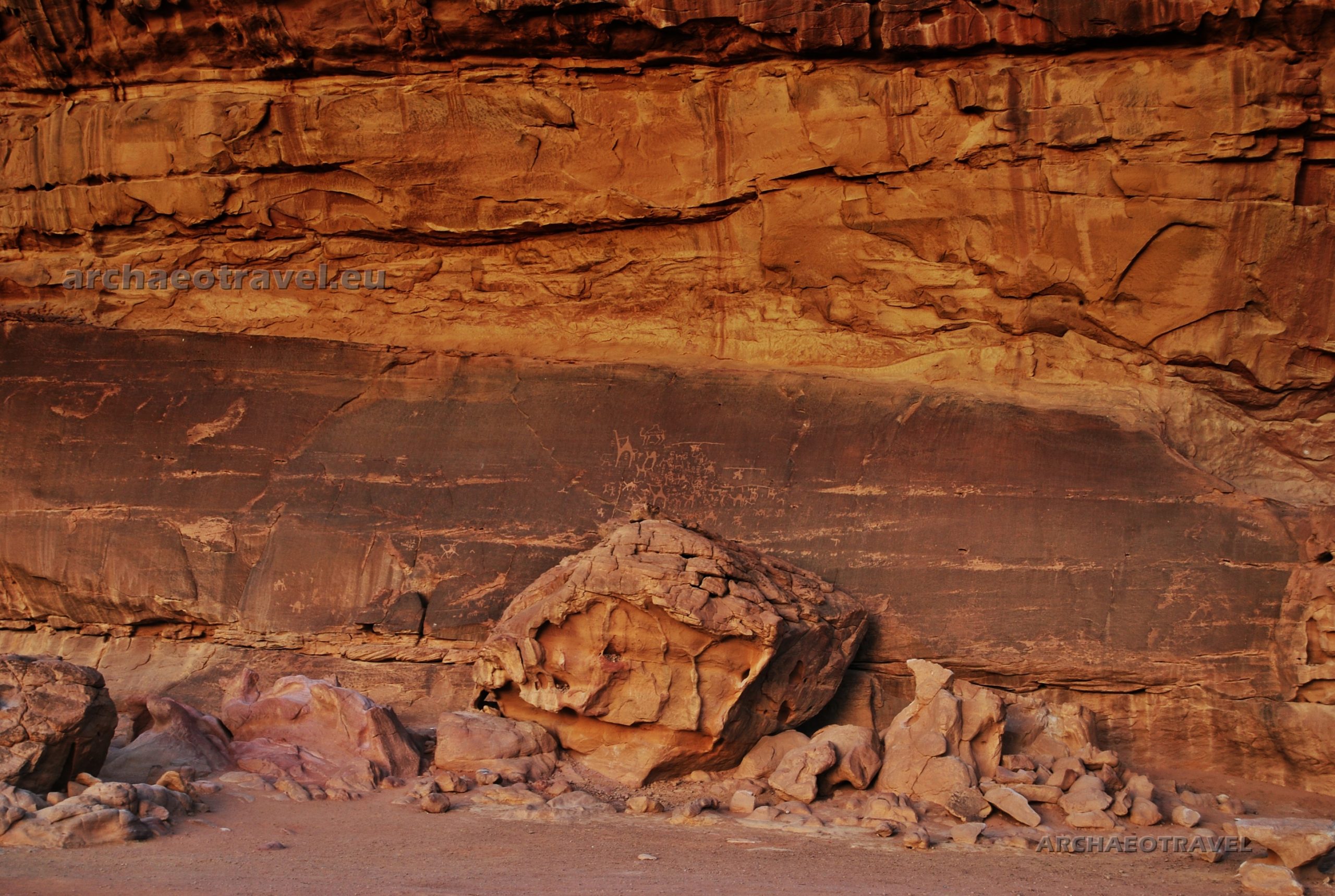
Petroglyphs
Within this area, groups of pre-historic petroglyphs have been found at several sites (Chabińska-Ilchanka et al. 2015:265). The rock drawings most likely come from twelve thousand years ago and prove the existence of settlement in this desert area since prehistoric times (Ibid.:265). Due to cultural landscape and its natural values, in 2011 the protected area of Wadi Rum was entered on the UNESCO World Cultural and Natural Heritage List (Ibid.:265).
Among the rock carvings that were found in Wadi Rum, there are twenty-five thousand figurative representations and twenty thousand characteristic signs looking like inscriptions that could constitute the first attempts to create a writing (Chabińska-Ilchanka et al. 2015:265; Mohammad 2015). The former usually represent people and animals, whereas among the latter, there are North-Arabian scripts: Nabatean, Islamic (Kufic), Arabic and mostly the so-called Thamudic inscriptions (Chabińska-Ilchanka et al. 2015:265; Mohammad 2015; “Wadi Rum” 2020; “Thamudic” 2020).
The Thamud
The Thamud belonged to ancient Arabian tribes occupying the north-western Arabian peninsula between the late eighth century BC and the fourth century AD (“Thamud” 2020). “They are mentioned in contemporary Mesopotamian, Classical, and Arabian sources” (Ibid.). It does not mean, however, all the petroglyphs from Wadi Rum were made by that tribe (“Thamud” 2020; “Thamudic” 2020). Actually, the name Thamudic was invented by nineteenth-century scholars for major part of inscriptions covering a huge area from Syria to Yemen (“Thamudic” 2020). “[Such inscriptions belong to a large group of] Ancient North Arabian (ANA) alphabets which have not yet been properly studied” (Ibid.).
The Nabatean
Many petroglyphs from Wadi Rum, however, are ascribed to Nabateans, an ancient nomadic Arab people who emerged between the fourth and second century BC and held their independence till the annexation of their territory to the Roman Empire in 106 AD (“Nabataeans” 2020). Nabateans are also said to be creators of Petra and although they surely inhabited the site, there is much doubt regarding the original builders of the city. It is, however, another story …
In tranquil and shaded Ain Shalaaleh, on the south side of Wadi Rum, there is the head of a Nabatean rock-cut aqueduct, which is close to Rum village and the remains of the Nabatean temple (Mohammad, “Confusion (….)” 2015).
Lawrence wrote that “[on] the rock-bulge above were clear-cut Nabathaean inscriptions, and a sunk panel incised with a monogram or symbol. Around and about were Arab scratches, including tribe-marks, some of which were witnesses of forgotten migrations: but my attention was only for the splashing of water in a crevice under the shadow of the overhanging rock. I looked in to see the spout, a little thinner than my wrist, jetting out firmly from a fissure in the roof, and falling with that clean sound into a shallow, frothing pool, behind the step which served as an entrance. Thick ferns and grasses of the finest green made it a paradise just five feet square.” (Lawrence 1935, p.355).
Images for communication
“Petroglyphs are images created by removing part of a rock’s surface by incising, pecking, carving, and abrading with something like a stone chisel. Inscriptions are characters [created just] in the same way as petroglyphs. Most petroglyphs [in Wadi Rum] were made on cliff faces, [large] rocks, and boulders” (Mohammad 2015).
The content of the petroglyphs and other artifacts found in the area are a source of knowledge about the social change and lifestyle of prehistoric desert tribes in the Arabian Peninsula (Chabińska-Ilchanka et al. 2015:265). “The illustrations of people show human figures holding bows and arrows” (Mohammad 2015). By their side, there is a large number of drawings representing animals, such as camels, ibexes, and horses (Ibid.). “[Alongside] all these figures are [enigmatic] symbols like lines and circles. Experts [assume] that they are instructions and messages left by [prehistoric] people [to communicate]. Some of them [may be] about giving directions to find hidden springs, [whereas others] about updating each other on things like who visited the area last. Altogether, these engravings [are believed] to provide an insight into the development of human thought [as] a pattern of pastoral, agricultural, and urban human activity” (Ibid.).
Scorpions were already asleep
We got off the car and approached one of the multiplied rocks. Its reddish surface was carved with intriguing images.
At first sight I could discern some animal figures, mostly camels. Yet some were rather difficult to guess. Whereas some camels were depicted in movement with funny forked tails, others were standing still and the one had an inscription inside its body. The biggest one with its long neck looked like a giraffe. Only its single visible hump indicated that it was a dromedary after all. There were also a few primitively drawn human figures with outspread arms and legs, who may stand for Neolithic members of a nomadic tribe. Those were quite similar to Neolithic human representations from northern Africa. Most intriguing, however, were strange symbols depicted around the recognized characters – one looked like a mountain peak – and inscriptions accompanying the whole scene. ‘I wish I could stay here longer and make drawings’, I thought while taking a thousand of pictures. Pushed by curiosity and in search of further images, I slipped under the rock ledge above the carvings. After a while I found there some traces of petroglyphs but mostly fragmented inscriptions. ‘You are a peeping type of a person’, said our Bedouin guide smiling. ‘It’s good that scorpions are already asleep’, he added.
It was pitch-dark when we finally reached back our camp. The electrical lamps illuminated a row of large tents waiting for tired visitors. We had just arrived to Jordan and Wadi Rum turned out to be our gate to its treasures.
By Joanna Faculty of History of Art and Archaeology Cardinal Stefan Wyszyński University in Warsaw, Poland UniversityCollege Dublin, Ireland
BIBLIOGRAPHY:
“Nabataeans” (2020) Wikipedia. The Free Encyclopedia. Available at <https://bit.ly/3nNAs8u>. [Accessed on 22nd November, 2020].
“Thamud” (2020) Wikipedia. The Free Encyclopedia. Available at <https://bit.ly/3lWe8cf>. [Accessed on 22nd November, 2020].
“Thamudic” (2020) Wikipedia. The Free Encyclopedia. Available at <https://bit.ly/3950pfL>. [Accessed on 22nd November, 2020].
“Wadi Rum” (2020) Wikipedia. The Free Encyclopedia. Available at <https://bit.ly/3kS4OoI>. [Accessed on 22nd November, 2020].
Biography (2014-2015) “T.E. Lawrence”. In: Biography.com. Available at <https://bit.ly/3kOf69e>. [Accessed on 22nd November, 2020].
Chabińska-Ilchanka, E., Dylewska K., Horecka K., Jaskulski M., Kastelik M. M., Łatka M., Ressel E., Willman A., Żywczak K. (2015) Niezwykłe miejsca świata. Warszawa: Wydawnictwo SBM Sp. zo.o.
Lawrence, T.E. (1935) Seven Pillars of Wisdom. Garden City: Doubleday, Doran & Company, Inc.
Mohammad, F. (2015) “Confusion about the Real Lawrence Spring Cleared”. In: Wadi Rum. Nomads. Available at <https://bit.ly/2J58ZA0>. [Accessed on 22nd November, 2020].
Mohammad, F. (2015) “The Petroglyphs and Inscriptions of Wadi Rum”. In: Wadi Rum. Nomads. Available at <https://bit.ly/36VBEjz>. [Accessed on 22nd November, 2020].
The Bronze Age. Dusk in the eastern Mediterranean (Westbrook 1995). The people on the island of Thera felt something frightening and cataclysmic in the air (Ibid.). They were preparing to abandon their home island (Ibid.). They had filled storage jars with wine, olive and wheat as if one day they would have come back to reclaim them (Ibid.). They carefully closed each lid (Ibid.). They also hid some valuables in their houses’ basements or under door frames (Mitchell 2011). Yet, their most precious possessions, like gold and jewels, they took with them (Westbrook 1995). They carefully sealed their houses as if protecting them from thieves and rushed to their boats (Mitchell 2011). What those people felt was the earth itself trembling beneath them but they had already survived similar earthquakes in the past (Westbrook 1995). That time, however, it was not a mere earthquake (Ibid.). Those people were to never return to their olive, wine and idyllic life they had depicted in their frescoes (Ibid.). They would have simply fled into the night and into the sea (Ibid.).
In the Mediterranean region, in the wide expense of the Blue Aegean Sea, a group of islands stands out in a Greek archipelago (Masjum 2006). They are thrown north of Crete, with a huge caldera at their center (Wengler 2009). The archipelago’s dark and brooding nature appears in contrast to the white limestone and pristine marble of the buildings (Masjum 2006). This islands are collectively known today as Santorini (Ibid.). The terraced landscape and rich volcanic soil make the them ideal for vineyards (History Channel 1980s). For this reason, Santorini is home to some of the finest wines in the world (Ibid.). But while tourists travel to Santorini for sun and the island’s quaint village life, archaeologists keep searching there for more clues about the destruction of the Minoan empire (Ibid.).
For years, teams of various scientists, each specialized in a particular field, have joined their forces to solve the mystery (Lilley 2006). They are still finding new evidence of a dreadful disaster that overwhelmed Europe’s first civilisation (Ibid.) ‘Did their terrible fate create the myth of Atlantis, the continent-city that drowned?’, speculates the archaeologist, Dr Sandy McGillivray (Ibid.). ‘They worshiped the sea and the sea [eventually] turned against them’ (Ibid.)
Everlasting myths
More than two thousand years ago, the Greek historian Plato wrote about Atlantis, the fabulous civilization that had been swallowed by the sea but no one has been able to trace the origins of Plato’s story yet (Lilley 2006). Appearing evidence from the island of Crete led some archaeologists to speculate that the Atlantis legend was in fact created in the Mediterranean (Ibid.). Is the legendary destruction of Atlantis just a folk memory of what happened to the Minoans, who flourished on Crete in the Bronze Age, over two thousand years before Plato? (Ibid.)
Atlantis was mentioned in Plato’s works Timaeus and Critias, in the fourth century BC. (Westbrook 1995; Harpur, Westwood 1997:18). The great Athenian philosopher claimed the story had originally come from Egypt (Westbrook 1995; Harpur, Westwood 1997:20). It was handed down to him from an Athenian lawmaker, Solon, who had in turn heard it from Egyptian priests from Sais, the capital of Lower Egypt (Ibid.). Solon, and after him Plato, both claimed these were facts, no fiction (Westbrook 1995; Harpur, Westwood 1997:20). According to their accounts, a highly advanced civilization would have developed on the island of Atlantis (Westbrook 1995; Harpur, Westwood 1997:18-21).
The Minoans
In the Bronze Age, the Greek islands were in fact home to an advanced civilization, competing for cultural, artistic and commercial influences in the region, even with the pharaohs of Egypt (Mitchell 2011). These were the Minoans (Ibid.). Centuries before the Greek built the Parthenon, Minoan artists recorded their achievements through exquisite carvings and stunning frescoes (Lilley 2006). They were the first Europeans to use writing but at the height of their powers they were wiped from the pages of history (Ibid.). Their disappearance is still one of the ancient world’s greatest mysteries (Ibid.). Some think the Minoans were slaughtered by conquers from overseas (Ibid.). Others claim that the cataclysmic eruption destroyed them (Ibid).
Apart from the legend of Atlantis, there are also other famous stories passionately haunting human imagination. Until the twentieth century, the Minoans had been the mysterious people known only from Greek myths about hybrid monsters and human sacrifice (Lilley 2006). The archaeologist, Dr Sandy McGillivray has been studying Minoan culture on Crete for twenty-five years (Ibid.). He has explored ancient caves in the centre of the island (Ibid.). For hundreds of years, people have believed their winding corridors were actually the Cretan labyrinth, which was the home of legendary Minotaur (Ibid.). Greek myths describe the beast as a feeding on human flesh, half-bull and half-human creature, who was imprisoned in the subterranean chambers by King Minos (Ibid.). According to the myth, the Minotaur had a very particular taste (Ibid.). He liked to consume its human prey alive (Ibid.). ‘To keep a Minotaur fed, Minos executed the tribute of seven maids and seven youths from the Athenians and once they entered the labyrinth, they never left it’, recounts Dr Sandy McGillivray (Ibid.). The myth suggests that Minoans practiced human sacrifice and were even cannibals (Ibid.). Or was this simply a propaganda generated by Greek fears of a powerful people? (Ibid.).
When the explosion of Thera occurred, the Minoan empire must have been at its highest (Westbrook 1995). However, despite their power and remarkable achievements, the Minoans disappeared after 1500 BC (Lilley 2006). Their fate is still a mystery (Ibid.). Were they wiped out by ancient Greek invaders, described by Homer in his epic poems about the Trojan war? (Ibid.). Or was it a catastrophic natural event, like the one that supposedly destroyed the Atlantis? (Ibid.).
Knossos
In 1900, the British archaeologist Arthur Evans started excavating at Knossos in northern Crete, near the modern capital of the island, Heraklion (History Channel 1980s; Lilley 2006). The whole western world was astonished by his discovery (Lilley 2006). Evans devoted forty years of his life to this endeavour, for which he was eventually knighted (History Channel 1980s).
After the excavations started, it shortly turned out that the archaeologist had come across the capital of the highly advanced civilisation of the Bronze Age (Lilley 2006). Whilst the ancient Europeans were living as barbarian warriors, building clay huts, Cretans were creating monumental architecture and living in overwhelming luxury (History Channel 1980s; Lilley 2006; Mitchell 2011). Men in Knossos must have moved about proudly and confidently (History Channel 1980s). Women were attired elegantly and glamorously (Ibid.). Evans exhumed in Knossos a huge architectural complex, he soon called a palace (History Channel 1980s; (Lilley 2006). It was a complex of buildings of the size of four football fields consisting of one thousand and three hundred courtyards, halls, passageways and rooms (History Channel 1980s; Mitchell 2011). All of them belonged to one single building, which was the heartbeat of the Minoan empire (History Channel 1980s). The palace was approached by massive entrance portals, leading deep inside its subterranean complex (Ibid.). Above the surface, the palace was two to three storeys high and built of cut stone (Ibid.). The walls were decorated with serene motifs of flowers and animals (Ibid.). War was not glorified there (Ibid.).
The architecture was so bewildering that Evans was convinced that he had found the Minotaur’s labyrinth, incorporated into the King Minos’ royal residence (History Channel 1980s). He found there marble walls and alabaster floors, which had been protected by the earth for millennia (Ibid.). In the lavishly decorated private chambers of the priest-king, as Evans assumed, a bathtub was even found (Ibid.). Staircases functioned as ingenuously designed air-conditioners (Ibid.). Light shafts provided subdued lighting (Ibid.). Below the floors, complicated drainage conduits have been built for bathrooms and, first in Europe, flush toilets (Ibid.). Even rainwater, which was collected in the open courtyards of the palace, passed through a special system of drains (Ibid.).
In the storehouses there were as many as four hundred storage vats for wine, oil, grains and honey (History Channel 1980s). The Minoans’ capital itself was a masterpiece of contemporary town planning, with its buildings being connected by Europe’s first paved roads (Lilley 2006). Surrounding the palace, there was a town with a population of more than forty thousand inhabitants (Ibid.).
The Empire
Based on what Evans found, archaeologists have built a more accurate picture of what this once great empire looked like (History Channel 1980s). Modern technology offers an impression of extraordinary splendour of the civilization around the whole Crete; ceremonial buildings, holy places, storehouses and workshops were once grouped around large central courtyards (Ibid.). Successively, archaeologists have discovered similar Minoan settlements with the so-called palaces throughout Crete and far beyond it (Lilley 2006). Among them, Knossos is believed to have been the most significant.
The Minoans were the contemporaries of the mighty ancient Egyptians, with a language of their own and a distinctive culture, widely revered by others (Masjum 2006). Highly cultured and civilized, the Minoans held much promise as a people (Ibid.). It was their culture that provided the seed of Greek civilization a thousand years later (Ibid.). They had an advanced state of bureaucracy and organization (Ibid.). The Minoans were equally skilled craftsmen capable of producing exquisite treasures and sophisticated objects of art (Lilley 2006). Their pottery was known throughout the contemporary world for its outstanding beauty and craftsmanship (History Channel 1980s). Its distinctive geometric patterns and naturalistic imagery were prized even by the pharaohs (Ibid.).
Merchants, not warriors
The source of Minoan wealth was their rule at sea (Mitchell 2011). They were peace-loving traders who placed strong emphasis on commerce and not war (Masjum 2006).
A geologist, Jelle Zeilinga de Boer, says that the Minoans created a commercial empire (Masjum 2006). ‘They did not have any defensive walls or anything to protect themselves because they had the [powerful fleet], and they were known in the entire eastern Mediterranean as traders’ (Ibid.). Also artistic influences of the Minoans were far-reaching (Wengler 2009). Minoan pottery and other various artifacts carried by their ships have been found from Spain to Mesopotamia (Lilley 2006). Their distinguished artistic style and motifs, flourished in frescoes also in foreign palaces of Mycenaeans, Egyptians and even Canaanites, such as Tel Kabri, in modern day Israel (Cline 2013). In the Egyptian city of Avaris (also Awaris), in the north-eastern region of the Nile Delta, the Egyptologist, Prof. Manfred Bietak has found a Minoan fresco, dated back to the sixteenth century BC. (Wengler 2009). It represents a recurring theme of the Minoan iconography, especially on Crete, which is a bull-leaping (Ibid.). Bietak claims that the fresco must have been painted by a Minoan artist, probably living and working in Avaris and decorating an Egyptian palace in a typical Minoan style (Ibid.). At the time of the Eighteenth Dynasty, the artistic influence of the Minoans on Egyptian art became highly noticeable (Ibid.). The presence of Minoan frescoes in the Nile Delta is further evidence of close contacts between these two worlds: Egyptian and Minoan (Ibid.).
Reconstructed Minoan Fresco from Tell El-Dab’a, in Egypt. The archaeological site is also known as Avaris, the capital of the Hyksos, which was developed in the Nile delta region of Egypt. However, the fresco itself is dated back to the Eighteenth Dynasty. It represents a bull-leaping, which is a recurring theme in Minoan art. Photo by Martin Dürrschnabel – Own work by Martin Dürrschnabel, de:Benutzer:Martin-D1,(2005). CC BY-SA 2.5. Photo and caption source: “Minoan Frescoes from Tell el-Daba” (2017). In: Wikipedia. The Free Encyclopedia.
In ancient times, the Minoans traded with the peoples of the Aegean and were amongst the first to sail to distant foreign lands (History Channel 1980s). After the British author, Gavin Menzies (2011), their boats voyaged westwards through the Pillars of Hercules to finally reach not only the British Isles but even northern America. Although scholars have rejected such theories as pseudohistory, all of them agree that the Minoan representatives surely travelled to the Near East and up the River Nile to the legendary city of Thebes, in Egypt (History Channel 1980s; Cline 2013). The palaces in their homeland of Crete, in Knossos, Phaistos and Malia were on a smaller scale than in Egypt but archaeologists claim to have observed in Cretan monumental architecture, structural designs similar to the temples dedicated to Egyptian gods, like Osiris, Isis or Hathor (History Channel 1980s). As Diodorus of Sicily writes in the first century BC. (Bibliotheca historica, Book I, 61), the architect of the labyrinth in Knossos, Dedalus, had first seen such an edifice in Egypt and designed a similar one for King Minos (Santarcangeli 1982:85). Although the Egyptian one was more monumental than the Cretan, it apparently served as its prototype (Ibid.:85).
On the other side, the Minoans’ maritime empire was so vast that it even rivalled the ancient Egyptians (Lilley 2006; Mitchell 2011). Nonetheless, the islanders must have been popular and respected in ancient Egypt (Ibid.), particularly because they did not sail with warships on buccaneering raids but as peaceful merchants (History Channel 1980s). Apart from mutual trading, as some scholars underline, there may have also been other Egyptian – Minoan relations, especially in the context of religion and ritual (Santarcangeli 1982:73-85). Yet, all of the sudden, all records of the Minoans came to an abrupt end in the papyrus texts of the Egyptian scribes. Why? (History Channel 1980s).
With time, the Minoans colonized Aegean islands also in the parts of mainland Turkey (Lilley 2006). Consequently, their powerful fleet could significantly control the Mediterranean’s trade routes (Mitchell 2011). At their intersection between Europe, Asia and Africa was Crete, the strategic centre of Minoan power (Ibid.). One hundred and twelve kilometres north lay the island of Thera, known today as the group of Santorini islands (Ibid.).
Restless island
The island of Santorini may provide a clue to solving the Minoan disappearance from history (Lilley 2006). The wild scenery and jagged cliffs draw countless tourists but they do not realize that this is in fact a highly explosive volcano (Ibid.). Nor did the colony of Minoans, who lived on Santorini in the Bronze Age and had built their town on the most dangerous island in Eurasia (Ibid.). At that time, the island was known as Thera. Its crescent shape testifies to a violent volcanic past (History Channel 1980s). Its harbour is now a gigantic caldera, so deep that no ship’s anchor can touch the bottom (Ibid.). In the middle, a volcanic dome rises out of the sea (Ibid.). Today it is an awesome monument to the fourth largest eruption in the last twenty thousand years (Ibid.). It was a cataclysm that some believed led the Minoan civilization to its final end (Ibid.).
In 1967, archaeologists discovered the Minoan town of Akrotiri, located on the southern coast of Santorini (History Channel 1980s). It was buried on the slopes of the vast volcano crater (Lilley 2006). Traces of Thera’s wealth can be seen in the ruins of this town (Mitchell 2011). Kitchens and storehouses offered a glimpse of people’s daily life (History Channel 1980s). At the moment they were found, storage jars still contained green kernels and olive pips (Ibid). Along the streets stood buildings whose walls were richly decorated with sophisticated frescoes (Mitchell 2011).
Famous Minoan Spring Fresco in the West Wall Swallows Scene, Akrotiri, Santorini. Subjects undertaken in art by the Minoans on Thera mostly showed the beauty and serenity of nature, with its different colours emanating during the day. Colours intensified. Photo and caption source: W. Sheppard Baird (2010). “Minoan Spring Fresco West Wall Swallows Scene”. In: Official Art Gallery.
Prof. Floyd McCoy, a geo-archaeologist, pays attention to the way Akrotiri’s inhabitants may have celebrated their life, which is well reflected in Minoan art. ‘If you take a look at the wall paintings that have been discovered [there], they are portraying their landscape. This is a happy landscape: animal bouncing around and [girls] picking saffron’, he says (Lilley 2006). ‘They [are] showing a nice lifestyle, comfortable one. It’s a pity it was all destroyed’ (Ibid.). People living on Thera, like the Cretans, built a highly advanced society, provided with such facilities as the world’s first home toilets combined with an underground sewage system (Mitchell 2011). For such a luxury most Europeans waited another two thousand years (Ibid.).
Island cursed by gods
In the rubble of the ancient town, scientists have found clues, which suggest that Thera eruption may have coincided with the downfall of the Minoan civilization (History Channel 1980s).
Gradually the buried city began to divulge its secrets (History Channel 1980s). However, working among the crumbling walls was dangerous and the man who first discovered Akrotiri, the veteran Greek archaeologist Spyridon Marinatos (1901-1974), was killed by falling rocks and buried in his town (Ibid.). His daughter, Nanno Marinatos, is carrying on his work (Ibid.). She says that most archaeologists agree that the Minoans established a theocratic empire of the seas (Ibid.). Still they do not know what their ruling class was like (Ibid.). Marinatos thinks that its representatives were priests and they claimed their special connections with a deity (Ibid.). Minoan priestesses apparently had the greatest power of all (Mitchell 2011).
Atlantis: End of a World, Birth of a Legend (2011): Director: Tony Mitchell; Writer: Rhidian Brook; Stars: Stephanie Leonidas, Reece Ritchie, Langley Kirkwood; Network: BBC One Documentary tells the story of the greatest natural disaster of the ancient world, an event that some experts believe inspired the legend of Atlantis. Source: Youtube.
As Marinatos claims, Minoan priests usually appeared in front of the public dressed as deities, which is well defined by the preserved frescoes (History Channel 1980s). Indeed, the Minoan art represents the mysterious world, where powerful priestesses performed strange and dangerous rituals (Mitchell 2011). Their task as it seems was to communicate with the gods, often through complex rituals in which saffron served as a hallucinogen (Ibid.). Like all ancient civilizations, the Minoans believed that their gods were present everywhere (Ibid.).
Fresco of a fisherman with Coryphaena hippurus from Akrotiri, Thera. Probably an offering to gods. Photo by Marcus Cyron (2008). Public domain. {{PD-US}}. Colours intensified. Photo and caption source: “Fresco of a fisherman” (2015). In: Wikimedia Commons.
Deity was responsible for every natural phenomenon, from the birth of a child to earthquakes, from the seas to the mountain peaks (Mitchell 2011). And the ancient peoples seemed to treat them as flesh and blood figures. Minoan gods were not considered gentle and merciful beings, but rather impulsive and often vindictive (Ibid.). To obtain the favour of the gods sacrifices were made to them and rituals were a way for priests to know their desires (Ibid.). In many houses in the town, rich and colourful paintings reveal images of the Minoan spiritual life: priestesses paying homage to their gods, maids and youths depicted at different stages of their initiation (History Channel 1980s). Even the young man with his abundant catch of fish, archaeologists believe may be on his way to the sacrificial altar (Ibid.). But with time, the Minoan belief system had to begin to break down (History Channel 1980s; Mitchell 2011). It was due to the geological forces that contributed to the destruction of Thera and this glittering world sank in the chaos of the powers of nature (Ibid.).
Earth-shaker is getting furious
In the second millennium BC., Akrotiri was shaken by a violent earthquake but this was merely the beginning of the natural disaster and subsequently the collapse of the entire Minoan civilization (History Channel 1980s; Mitchell 2011).
Stone Staircase destroyed by a devastating earthquake in ancient city of Akrotiri, Thera. It was also one of the warnings, announcing the final explosion of the volcano. Photo and caption source: Alan V. Morgan (2020). “Stone Staircase in a Wrecked Building at Akrotiri”. In: The Greek Field Trip, 1994.
One of the most powerful Minoan gods was called ‘earth-shaker, also identified with Poseidon (Harpur, Westwood 1997:18; Mitchell 2011). As a deity, he was responsible for sea powers and earthquakes and for this reason he was particularly frightening (Ibid.). Structural damage discovered on Thera shows that just before the volcanic eruption there was an earthquake with magnitudes exceeding seven degrees on the Richter scale (0-9) (Mitchell 2011). The buildings on Thera had been designed to withstand weaker shocks, which usually happened in that region (Ibid.). The houses were therefore strengthened by a skeleton made of thick, wooden logs (Ibid.) However, that earthquake was strong enough to smash a stone staircase, as it is visible in ancient Akrotiri, and triggered a series of fatal events for the inhabitants of Thera (Ibid.).
Heralds of the coming disaster
Yet before the deciding earthquake came, the great eruption announced itself slowly and gradually (Wengler 2009). As the black mountain, the volcano was slowly coming to life (Ibid.). One of the first signals of volcano activity were hydrothermal explosions caused by heated groundwaters (Mitchell 2011). Boiling fountains of steam bursting from the sea were accompanied by the first tremors shaking the island (Wengler 2009). Sea quakes caused giant waves to form (Ibid.). These were the heralds of the coming disaster a few months ahead (Ibid.) A Minoan wall painting from the island of Santorini represents a giant wave and drowning people beneath it (Ibid.). Is this a portrayal of the events just before the eruption? (Ibid).
Detail of the so-called Naval Battle shown on the north wall frieze of Room 5 of the West House in Akrotiri, Santorini. Some scholars think that casualties in the water have resulted from the naval battle, others point to giant waves of the sea quakes, which were the heralds of the coming eruption. Source: Antiquated Antiquarian (2015). “The Minoans: Frescoes”. In: The Stream of Time.
For over seventeen thousand years, the magma reservoir beneath the island’s surface was closed but recurring tremors kept deepening cracks and lava began to rise (Mitchell 2011). The rising magma was accompanied by the larger release of sulphurous vapours and other toxic gases (Ibid.). It was another sinister harbinger of the approaching eruption (Ibid.). Foul-smelling sulphurous vapoursemerged and spread (Wengler 2009).
Certainly, for the inhabitants of the island it became a race against time (Wengler 2009). According to archaeological research, the damage after the final earthquake was so severe that residents of Akrotiri had to leave their weakened homes and probably moved to temporary camps, in the hope that they would be able to return to their town soon (Mitchell 2011). “There is evidence [that] people [even] started to repair the damage, but before repairs were complete, another set of quakes hit the town. It appears people abandoned it then and left fairly quickly, as many belongings were [found in Akrotiri]” (Jensen 2018). Undoubtedly, the residents had tried to save whatever they could (Wengler 2009). Just before the eruption, they managed to gather food and water supply and other domestic equipment, but eventually, food jars and the beds tied together and ready to go had to be left behind (Ibid.). The excavations at Akrotiri has showed that while some houses were almost completely emptied before eruption (Ibid.), in others, precious belongings were found safely under the bed or wooden frame (Mitchell 2011). Houses’ doors were shut tight (Ibid.). When the mountain belched hot volcanic ash, for the Minoan islanders it was high time to leave their island (Wengler 2009). Experts believe the population got off Thera just in time; unlike in Pompeii, no trace of human remains have ever been found in Akrotiri (Wengler 2009; Jensen 2018). Yet nobody knows where they sailed to take refuge (Wengler 2009).
Stages of eruption
‘And suddenly [the volcano] exploded’, says Prof. Floyd McCoy, a geo-archaeologist (Lilley 2006). Thera was erupting (Ibid.). The vast volcano blasted ash, gas and rock up to into the stratosphere (Ibid.).
On Santorini, a team of geologists, volcanologists, botanists, archaeologists and physicists has regularly studied the site of the disaster (Wengler 2009). Evidence of the volcano power is all around the island (Lilley 2006; Mitchell 2011). There are deposits that are more than sixty metres deep in places (Lilley 2006). The scientists have made an attempt to reconstruct different stages of the Thera’s eruption (Ibid.). ‘There, in that cliffs face,’ Prof. Floyd McCoy points to the multicoloured high rock face on Santorini, ‘[there are] all four [visible] layers representing the four major faces of this huge dramatic eruption’ (Ibid.).
Ruthless gods
Following the final earthquake, the pressure of magma burst the rock, which for thousands of years had clogged the volcano funnel (Mitchell 2011). It was only a preview of an impending explosion (Ibid.). The volcano was only clearing its throat (Ibid.).
Earlier generations had already seen similar but minor eruptions and recognized them as signs from the gods (Mitchell 2011). These were signs whose understanding was the task of the priests (Ibid.). For the Minoans, there was no better way to satisfy threatening and unpredictable gods than through sacrifice (Ibid.). They performed such rituals in sanctuaries, high in the mountains, where they were physically closest to the gods (Ibid.). Twenty-three such places have been discovered in Crete itself, and in them the remains of thousands of clay figurines (Ibid.) Clay parts of the body were to heal the same human limbs, and animal figurines were to heal and protect livestock (Ibid.). In Minoan shrines, bones of animals have also been found, of goats, sheep, pigs and even bulls (Ibid.). Possibly blood sacrifice was considered the most powerful (Ibid.). The power of priests and priestesses depended on their ability to win the favour of the gods, but the forces released beneath Thera’s surface could not be stopped any more (Ibid.). Consequently, confidence in the powers of priests weakened, which eventually led to the collapse of Minoan social and religious systems (Ibid.).
From the earthquake to Plinian eruption
Plinian eruption of Mt. St. Helens on May 18, 1980. USGS Photograph taken on May 18, 1980, by Donald A. Swanson. Photo and caption source: Volcano Discovery (2020). “Illustrated Glossary: Plinian eruption. Volcanology”. In: Volcano Discovery.
From the structure of volcanic sediments in the initial phase of eruption, the island was covered with bright ash (Mitchell 2011). It was enough to poison the sources of drinking water (Ibid.). But it was not the worst awaiting the people living on Thera (Ibid.). What distinguished this eruption from all others experienced so far by the inhabitants of the island was the interaction of two types of magma that triggered a catastrophic chemical reaction (Ibid.). This reaction spewed about a hundred and fifty billion tons of magma onto the surface and made the eruption the greatest natural disaster of the ancient world (Ibid.). Columns of glowing gas of ash and stones flew at over nine kilometres up into the stratosphere, forming a cloud shaped like an atomic mushroom (Ibid.). Consequently, large clouds of rubble and dust rose into the sky after the explosion (Ibid.). Their force can be compared to the detonation of a nuclear bomb (Ibid.). The sound of explosion must have been heard even in Egypt, and clouds of smoke have been seen from Crete after a few minutes (Ibid.).
Atlantis: End of a World, Birth of a Legend (2011): Director: Tony Mitchell; Writer: Rhidian Brook; Stars: Stephanie Leonidas, Reece Ritchie, Langley Kirkwood; Network: BBC One Documentary tells the story of the greatest natural disaster of the ancient world, an event that some experts believe inspired the legend of Atlantis. Source: Youtube.
Thera’s eruption has been called the Plinian, which is the most devastating of all (Mitchell 2011). “Plinian eruptions or Vesuvian eruptions are […] marked by their similarity to the eruption of Mount Vesuvius in 79 AD, which destroyed the ancient Roman cities of Herculaneum and Pompeii. The eruption was described in a letter written by Pliny the Younger, after the death of his uncle Pliny the Elder” (“Plinian eruption” 2020). Hence its name. Such “eruptions are marked by columns of volcanic debris and hot gases ejected high into the stratosphere, the second layer of Earth’s atmosphere. The key characteristics are ejection of large amount of pumice and very powerful continuous gas-driven eruptions” (Ibid.)
Shot from the documentary: Atlantis: End of a World, Birth of a Legend (2011): Director: Tony Mitchell. Source: Yesterday (2020). “Atlantis – End of a World, Birth of a Legend”. In: Yesterday.
During the first four hours of Thera’s eruption, the volcano ejected five billion tons of magma from the crater (Mitchell 2011). The day turned into night, because volcanic dust began to cover the entire island (Ibid.). The cooling magma began to fall as pumice (Ibid.). These were small stones filled with air bubbles but deadly in such large quantities (Ibid.). Prof. McCoy points out to the cliffs on Santorini, saying that at this stage of the eruption, the first layer was created (Lilley 2006). ‘[It] is that brown [one] at the bottom. [This] granular brown layer that’s pumice. Pumice is frothy rock. It represents magma frozen in place, a frozen explosion’, he says (Ibid.).
Deadly ashes
Probably one of the first stages of an initiation for Minoan women: a young girl gathering saffron. Fresco from Akrotiri, Thera. Anonymous author. Public domain. Created: 1600-1500 BC. Photo source: “Wall Paintings of Thera” (2020). In: Wikipedia. The Free Encyclopedia.
But it was ash, not pumice stone, that posed the greatest threat (Mitchell 2011). Volcanic ashes are different from ordinary ones, as they contain silicone (Ibid.). Drawn into wet human lungs, volcanic ash turns into liquid cement (Ibid.). Breathing then is difficult and finally impossible (Ibid.). Although archaeologists have not found any human remains in Akrotiri, it is still possible some residents of the town could have been stopped on the island, imprisoned by subsequent deadly effects of the eruption, either in their contemporary camps (Ibid.), or elsewhere on the island. Some scholars estimate that in Thera’s case, there were probably only few survivors who had escaped the island (Mitchell 2011).
Pyroclastic flows and torrential rains
The layer on top of the pumice from the cross-section of the cliffs proves the real power of this mighty eruption (Lilley 2006). This is the ash left by pyroclastic flows (Ibid.). ‘Pyroclastic flows [are made by] hot gas material that comes up and flows laterally across the landscape, sometimes at supersonic speeds’, says Prof. McCoy (Ibid.). These gases were forced out by massive explosions in the heart of the volcano, the caldera (Ibid.). But what caused these blasts? (Ibid.).
The archaeological site of Akrotiri on Santorini island. The ancient houses were strengthened by a skeleton made of thick, wooden logs to avoid their destruction during often on Thera earthquakes. Photo source: photos of the archaeological site of Akrotiri. In: Print & Web Guides Ltd. (2020). “Akrotiri” In: Santorini Island, Greece.
When the magma first erupted, it left behind a huge empty chamber (Lilley 2006). The surface above the chamber collapsed, creating a vast cavity (Ibid.). Then seawaters rushed into the expanding crater (Mitchell 2011; Lilley 2006). Upon contact with magma, the water turned into vapour, starting another wave of eruptions (Mitchell 2011). ‘Magma and water do not mix [but] create an explosion’, explains Prof. McCoy (Lilley 2006). ‘The entire Aegean Sea [was] pouring in this vent, mixing with new magma coming up and explosion was tremendous […] and from that [came] these pyroclastic flows’ (Ibid.).
The violent reaction of water with magma led to a phreatomagmatic eruptions (Mitchell 2011). It is estimated that the sound pressure level of this explosion reached three hundred decibels (Ibid.). It was enough to burst the tympanic membrane of everyone within sixteen kilometres (Ibid.). Moreover, the power of this eruption threw rocks from the inside of the crater, turning them into deadly rockets – lava bombs (Ibid.). Such burning lumps of stone could reach the size of a small truck and weigh up to eight tons (Ibid.). As the crater widened, the pressure was pushing the column upwards (Ibid.). The gases and rocks forming it began to fall in all directions (Ibid.). Pyroclastic flows reached the speed of two hundred and ninety kilometres per hour and a temperature of seven hundred degrees (Ibid.). Finally, the sizzling wave of rocks fell into the sea, and when it made the water surface boil, it began to move even faster on the layer of hot steam (Ibid.). After the final monstrous pyroclastic flow, ten metres deposit of ash and pumice were left, which have eventually formed the third layer that the best demonstrates the awesome forces of this eruption (Lilley 2006).
And on their top Santorini cliffs are built of the final, fourth layer (Lilley 2006). ‘It started to rain’, says Prof. McCoy (Ibid.). ‘Torrential rains came down and then all this loose ash and pumice on the surface started to move downslope. That’s what we call debris flows and then it was over’ (Ibid.).
Far-reaching disaster
What caused Thera eruption to be so far-reaching? (Masjum 2006). Thera sat on a string of volcanic islands straddling four plates (Ibid.). This convergence of plates creates the chain of volcanic islands and makes Thera eruption highly potent (Ibid.). Magma is formed when the African plate gets pushed beneath the Eurasian (Ibid.). The result is a gas rich and thick magma that erupts explosively (Ibid.). Prof. McCoy believes that the explosion was so loud that it could be heard throughout southern Europe, northern Africa and the Middle East (Ibid.).
More importantly, the blast has changed completely the shape of the land (Masjum 2006). Thousands years before the Minoan eruption, Santorini was believed to have joined as one island but after several eruptions the single island was blasted apart into smaller ones (Ibid.). At the time of the Minoans, the volcano was situated at the centre of these islands (Ibid.). When it erupted, it again changed the shape (Ibid.). When the centre of the volcano eventually collapsed, it formed a huge caldera (Ibid.). Today all that remains of the volcano is Nea Kameni, a tiny uninhabited island within the flooded Santorini caldera (Ibid.). With the birth of this new island the volcano is slowly rebuilding itself (Ibid.). Prof. McCoy claims that ‘over next twenty thousand years, this island is going to get larger and larger and then possibly it explodes again’ (Ibid.). ‘In the course of history of this volcano, an eruption repeats itself every twenty thousand years’, he explains (Ibid.).
Shot from the documentary: Atlantis: End of a World, Birth of a Legend (2011): Director: Tony Mitchell. Photo source:Nigel Jones (2011). “Blast from the Past! With the Most Breathtaking CGI Effects ever Seen on TV, a Drama that Imagines Atlantis’s Catastrophic End Makes for Explosive Viewing”. In: Mail Online.
I sat down on a whitewashed fence interrupted by the deep blue of a wooden gate suspended over a steep cliff. Only the navy blue waters of the sea stretched further, fading into turquoise green, crashing against the feet of the island. The idyllic landscape and tranquility of the island contrasted strongly with the ragged nature whose dormant forces were likely to wait yet a while before they finally break free.
Featured image: Shot from the documentary: Atlantis: End of a World, Birth of a Legend (2011): Director: Tony Mitchell. Photo source: Far Future Horizons (2016). “Atlantis: The End of a World and the Birth of a Legend”. In: Far Future Horizons.
By Joanna Faculties of English Philology, History of Art and Archaeology. University of Silesia in Katowice, Poland; Cardinal Stefan Wyszyński University in Warsaw, Poland; University College Dublin, Ireland.
BIBLIOGRAPHY:
“Fresco of a fisherman” (2015) Wikimedia Commons. Available at <https://bit.ly/3bYd7e8>. [Accessed on 26th May, 2020].
“Hatshepsut” (2020). In: Wikipedia. The Free Encyclopedia. Available at <https://bit.ly/2Agm19s>. [Accessed on 27th May, 2020].
“Minoan Bull-leaper” (2020). In: Wikipedia. The Free Encyclopedia. Available at <https://bit.ly/2TJkdNa>. [Accessed on 27th May, 2020].
“Minoan Frescoes from Tell el-Daba” (2017). In: Wikipedia. The Free Encyclopedia. Available at <https://bit.ly/2TKUVhG>. [Accessed on 27th May, 2020].
“Wall Paintings of Thera” (2020). Wikipedia. The Free Encyclopedia. Available at <https://bit.ly/2XL26YH>. [Accessed on 26th May, 2020].
“Ahmose I” (2020) Wikipedia, the Free Encyclopedia.Available at <https://bit.ly/2ZRB9Vw>. [Accessed on 28th May, 2020].
“Plinian eruption” (2020). In Wikipedia. The Free Encyclopedia. Available at <https://bit.ly/2XiOIe1>. [Accessed on 22nd May, 2020].
“Tempest Stele” (2020) Wikipedia, the Free Encyclopedia.Available at <https://bit.ly/36F3NdS>. [Accessed on 28th May, 2020].
Antiquated Antiquarian (2015). “The Minoans: Frescoes”. In: The Stream of Time. Available at <https://bit.ly/2XGi4mv>. [Accessed on 28th May, 2020].
Cline E. H. (2013). “Aegeans in Israel: Minoan Frescoes at Tel Kabri.” In: Biblical Archaeology Review 39 (4), pp. 37-44+64.
Eptakili T. (2017). “A Life’s Work: The Excavation of Akrotiri in Santorini”. In: Greece Is Santorini. Available at <https://bit.ly/2zD4loH>. [Accessed on 28th May, 2020].
Far Future Horizons (2016). “Atlantis: The End of a World and the Birth of a Legend”. In: Far Future Horizons. Available at <https://bit.ly/3cbzfl6>. [Accessed on 28th May, 2020].
Harpur J., Westwood J. (1997) The Atlas of Legendary Places. New York: Marshal Editions.
History Channel (1980s). Crete. Death came from the Sea. Time Life’s Lost Civilizations. Available at <https://bit.ly/3d3mCKx>. [Accessed on 21st May, 2020].
Jensen M. N. (2018) “Dating the ancient Minoan eruption of Thera using tree rings” In: UA College of Science. Available at <https://bit.ly/36D5GI8>. [Accessed on 28th May, 2020].
Jones N. (2011). “Blast from the Past! With the Most Breathtaking CGI Effects ever Seen on TV, a Drama that Imagines Atlantis’s Catastrophic End Makes for Explosive Viewing”. In: Mail Online. Available at <http://dailym.ai/2ZKtlF3>. [Accessed on 28th May, 2020].
Lilley H. (2006). The Real Atlantis. A Quickfire Media Wales Production for BBC and Arte France.
Masjum M. (2006). Inside the Volcano. Kraylevich Productions Inc.; Mechanism Digital.
Menzies G. (2011). The Lost Empire of Atlantis: History’s Greatest Mystery Revealed. Orion Publishing Group, Limited.
Mitchell T. (2011). Atlantis: End of a World, Birth of a Legend. BBC Production.
Morgan A. V. (2020). “Stone Staircase in a Wrecked Building at Akrotiri”. In: The Greek Field Trip, 1994. Available at <https://bit.ly/2TDUzJC>. [Accessed on 26th May, 2020].
Photos of the archaeological site of Akrotiri. In: Print & Web Guides Ltd. (2020). “Akrotiri” In: Santorini Island, Greece. Available at <https://bit.ly/3d39fd1>. [Accessed on 25th May, 2020].
Santarcangeli P. (1982). Księga Labiryntu [Il libro dei Labirinti]. Bukowski I. trans. Warszawa: Wiedza Poweszechna.
Sheppard Baird W. (2010). “Minoan Spring Fresco West Wall Swallows Scene”. In: Official Art Gallery. Available at <https://bit.ly/2ZKidrV>. [Accessed on 28th May, 2020].
Volcano Discovery (2020). “Illustrated Glossary: Plinian eruption. Volcanology”. In: Volcano Discovery. Available at <https://bit.ly/2M2zX9V>. [Accessed on 27th May, 2020].
Wengler G. (2009). The Biblical Plagues; Episode 2: Darkness Over Egypt. Taglicht Media GMBH; ZDF Enterprises.
Westbrook J. (1995). Time life’s: Lost Civilizations; Episode 4: Aegean: The Legacy of Atlantis. Time-Life Video & Television.
Yesterday (2020). “Atlantis – End of a World, Birth of a Legend”. In: Yesterday. Available at <https://bit.ly/2M8O2mm>. [Accessed on 28th May, 2020].