Category Archives: SRI LANKA

Unique Pyramid of Polonnaruwa with Little Trace in History

In my head I could still hear the noise of the airport, a commotion and rush at the customs control and at baggage claim, when I suddenly fell into the arms of tropical scenery, with its heavenly peace and tranquility given by the sound of the river and the whisper of huge leaves swaying in the wind. Hidden in the shadow of the tall boughs on the shore, I lazily observed a bright sunlight pouring profusely over the river and a group of elephants frolicking in it.

At first, I could not believe that I had become part of this picturesque image: in the background of a dense curtain of tall palm trees and thick creepers protruding from green ficuses and their trunks, heavily wrinkled bulks of elephants were wading in the silvery water of the river. Some turned over and poured water on each other, using their long trunks like watering cans.

Rhapsody for an elephant

Elephants have always been a very important national element of Sri Lanka and as such these animals have become part of the folklore and leading characters of Southeast Asian legends. Throughout ages, men in Asia have taken numerous advantages of elephants’ strength to create massive constructions, using the animals not only for dragging heavy loads and their transportation but also for military purposes. The aforementioned king of Sigiriya, Kashyapa (also Kassapa), was to take part in his last fight also on the back of an elephant (see: In the Realm of Demon Ravana).

Especially the white elephant with long tusks has always been of a great importance to both, Hinduism and Buddhism, where, as tradition says, it serves either as a mount for the Hindu god, Indra, or appears in a dream of the mother of Gautama Buddha, just before he is conceived. The white elephant is an equally significant symbol of the royal power in Sri Lanka. During the processions of religious festivals in Kandy, the king’s white elephants have driven a reliquary with the most venerated there a Buddhist relic, namely, the famous Buddha Tooth preserved to our times, and brought to the island in the fourth century AD. by Mahinda’s sister, Sanghamitta. The same relic had previously been also preserved in another ancient capital of Sri Lanka, Polonnaruwa, where it was possibly housed in the shrine of Hatadage.

Tired after the journey in the cramped seat of the plane, I was laying on the steps of the stairs leading down to the river, and I was watching a wonderful spectacle of playing elephants as if I had been in a daydream. But such a sweet laziness could not last forever. And after a short break in Pinnawala, a famous elephant orphanage on the island, we finally set off on the way to meet archaeology of one of the ancient capitals of Sri Lanka.

Gateway to the ancient city of Polonnaruwa

The ancient city of Polonnaruwa was first designed as a country residence before it became the successive capital of the Sinhalese kings, after the destruction of the former royal centre in Anuradhapura, in 993 AD. (UNESCO 2021; Brown D. Brown J. Findlay 2005).

In the foreground of the remnants of the Palace of the kings of Polonnaruwa. Copyright©Archaeotravel.

Actually, Polonnaruwa was designated as a capital by the Chola dynasty, who abandoned the previous one in Anuradhapura for strategical reasons (Brown D. Brown J. Findlay 2005; Wulff Hauglann 2020; Saumya 2020). In 1070 AD., it was, however, overtaken by Sinhalese kings who kept Polonnaruwa as their capital (Brown D. Brown J. Findlay 2005; Wulff Hauglann 2020; Saumya 2020). As a matter of fact, it was during the Sinhalese rule when the city’s glory reached its peak (Wulff Hauglann 2020; Saumya 2020). Among the greatest kings of that period was the second king who ruled the capital, namely King Parakramabahu the First, whereas the third one, the King Nissanka Malla (1187 – 1196) eventually led the kingdom to bankruptcy and so, in the early thirteenth century, the glory of Polonnaruwa had ceased (Brown D. Brown J. Findlay 2005; Wulff Hauglann 2020; Saumya 2020). Finally, it was abandoned, and the Sinhalese capital was moved to the western side of the island, to the city of Kandy, which became the very last capital of the ancient kings of Sri Lanka (Brown D. Brown J. Findlay 2005; Wulff Hauglann 2020; Saumya 2020).

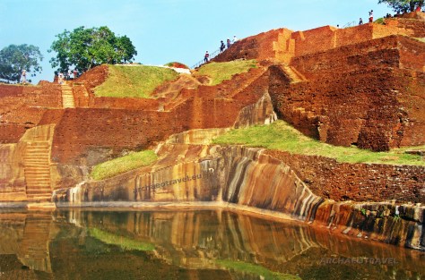
Part of the Cultural Heritage Triangle of Sri Lanka

Together with two other historical capitals, Anuradhapura and Kandy, the city of Polonnaruwa creates one of the three angles of the pyramid-shaped graphic sign of the Cultural Heritage Triangle of Sri Lanka (Saumya 2020; see: In the Realm of Demon Ravana). As an archaeological and a UNESCO World Heritage site, Polonnaruwa comprises numerous monuments of different periods and functions; besides the Brahman ruins of the Cholas rule, from between the tenth and eleventh centuries, there are picturesque remnants of abundant Sinhalese constructions, built between the twelfth and thirteenth centuries, including a famous king’s, Parakramabahu the First, magnificent garden-city (UNESCO 2021; Brown D. Brown J. Findlay 2005; Wulff Hauglann 2020; Saumya 2020).

Unknown building among royal and sacred edifices

Almost all the constructions in the area of Polonnaruwa are historically recorded (Mohan 2019). Apart from earlier temples dedicated to Hindu gods, there are mostly secular buildings, like the Royal Palace and the Audience Hall, and Buddhist shrines, most famous of which are Dalada Maluva, including the Sacred Quadrangle with the unique Vatadage (Brown D. Brown J. Findlay 2005; Wulff Hauglann 2020; Saumya 2020), “where the Tooth Relic of Lord Buddha was housed” (Bell 1903:14-15 in: Manatunga 2009:2004), Lankatilaka Vihara and Gal Vihara (Brown D. Brown J. Findlay 2005; Wulff Hauglann 2020; Saumya 2020).

The Satmahal Prasada in Polonaruwa. The only feature that may give some insight into the origins of Sathmahal Prasada are sculpted statues. Nevertheless, their identity has been disfigured by intentional destruction. Copyright©Archaeotravel. Photo by Bernard Gagnon (2006). CC BY-SA 3.0. Photo source: “Satmahal Prasada” (2021). Photo source: Wikipedia. The Free Encyclopedia.

Nevertheless, there is no account of a pyramidal-like stepped edifice situated in an elevated area, which is generally perceived as the most mysterious structure of all in the whole ancient city and sometimes the only ancient pyramid in Sri Lanka (Mohan 2019; Manatunga 2009:2004; Lapkura 2021).

Named as Sathmahal Prasada

The structure has been named in modern times as Sathmahal Prasada, which literally means a seven-storey building (Mohan 2019). It is located in the proximity of the Vatadage and so it is included within the Buddhist complex of Dalada Maluva (Brown D. Brown J. Findlay 2005; Wulff Hauglann 2020; Saumya 2020). This is why Anura Manatunga (2009:204) thinks it was also build for religious purposes  as other constructions on site. For this reason, Sathmahal Prasada is believed to have served as a stupa, built in the proximity of other prominent Buddhist ruins such as stupas and monasteries of Polonnaruwa (Lapkura 2021).

As much as the Quadrangle may have played the role of the most important royal monastery of Sinhalese kings ruling in the city, Sathmahal Prasada must have had a very significant function as well (Manatunga 2009:204). Yet, the pyramid may not have belonged to the Buddhist complex originally (Mohan 2019). And as Anura Manatunga (2009:204) admits the construction “is still unidentified and remains an ambiguous monument [as] we cannot [pinpoint its] builder, purpose or even the ancient name of the building”.

Accordingly, experts do not know who built it or why it was built (Mohan 2019; Manatunga 2009:204; Lapkura 2021). Its original name is equally lost in history (Mohan 2019; Manatunga 2009:204). As such, it can be described only by means of its appearance and it actually resembles a stepped pyramid with entrances on all four sides (Mohan 2019; Lapkura 2021). Moreover, it is also one of no more than four other ancient constructions on the island with square bases, providing that the others are all older religious ruins in Anuradhapura, most of which are damaged (Lapkura 2021). It is equally worth mentioning that none of the three structures reveal any signs of having been pyramids and all appear to have been rather squat in their shape (Ibid.).

Origins shrouded in mystery

Due to its growing mystery, Sathmahal Prasada has continuously provoked some new theories and scholars’ guesses concerning its provenience and function (Manatunga 2009:204-205). For example, Don Martino de Zilva Wickremasinghe (1865–1937), an epigraphist and archaeologist of Sri Lanka, speculates (1928:92-93) that it may have been once a palace, as much as it is claimed today about the function of the construction on top of the Rock of Sigiriya (Ibid.:204). The scholar based his theory on the fact that epigraphical sources say that one of the most famous kings of Polonnaruwa, Nissanka Malla (1187- 1196) had built a seven-storey palace for himself (Ibid.:204). Nevertheless, unlike in the case of the so-called ‘Palace’ on top of Sigiriya, academics commonly agreed that “the solid tower-like building [of Sathmahal Prasada] is not habitable and, therefore, cannot be residential building” (Ibid.:204).

Another symbolic representation of the Mount Meru in the shape of a pyramid

Most relevant of all seems to be a suggestion made by Ananda Coomaraswamy (1877-1947), a Sri Lankan Tamil metaphysician, pioneering historian and philosopher of Indian art, who proposed  (1965:165) that Sathmahal Prasada actually represented the mythical Mount Meru, as much as many other examples of sacred architecture in Southeast Asia and in India (Manatunga 2009:204). Some alternative authors even claim it has similarities with pyramidal architecture, created by contemporary oversea cultures (Lapkura 2021).

A Buddhist monk passing by Sathmahal Prasada, in Polonnaruwa. Copyright©Archaeotravel.

Harry Charles Purvis Bell (1851-1937), who was the first Commissioner of Archaeology in Ceylon, describes Sathmahal Prasada in his Annual Report of the Archaeological Survey 1903, 1906, and 1910 (2009:14) as “a solid brick structure with seven storeys that diminished in width and height stage by stage” (Manatunga 2009:204). And although he does not directly call it a pyramid, his narrative undoubtedly identifies it as a pyramidal structure. HCP Bell (1903:14) also adds  that “[the] top of the building has collapsed but it is still high, at 53 feet, [which is over 16 metres. And] at the ground level it is a 39 [feet] 2 inches square building, [that is, almost 12 metres]” (Ibid.:204).

Southeast Asian affinities

In terms of the construction’s origins, Anura Manatunga (2009:204) claims that Sathmahal Prasada, together with Gal Vihara statues and Pothgul Vehera, shows more likely Southeast Asian affinities. Her theory is also supported by earlier authorities (Ibid.:204-205). Reginald Le May (1885-1972), a British art historian and a Honorary Member of the Siam Society, writes in A Concise History of Buddhist Art in Siam (1962:97-98) that Sathmahal Prasada bears some similarity to a bigger and taller pyramidal structure of Wat Kukut in Northern Thailand, which is additionally contemporary to the Polonnaruwa Quadrangle (Ibid.:205). Among other contemporary Thai constructions similar to Sathmahal Prasada, the book Sri Lanka and South-East Asia: Political, Religious and Cultural Relations from A.D. C. 1000 to C. 1500 by W. M. Sirisena (1978:123) also enumerates Suwanna Chedi in Wat Phrathat Hariphunchai, which is also pyramidal in its structure (Ibid.:204).

On the other side, HCP Bell (1903:14-15) claims that Sathmahal Prasada resembles more Khmer constructions of the Angkor complex in Cambodia (Manatunga 2009:204). Accordingly, the construction would be “an architectural link between the simplest form of rectangular pyramid such as Ka Keo, [possibly Ta Keo] with plain vertical walls and strait of stairs up the middle of each side and the elaborate towers at Mi-Baume, [in Angkor Wat] and other similar shrines” (Bell 1903:14 in: Manatunga 2009:204).

Mysteries come in pairs

Nowadays, in its ruined but still pyramid-like shape, Sathmahal Prasada is usually compared to an equally mysterious Khmer temple in Cambodia, namely, the unique pyramid of Prasat Thom (Prang) of Koh Ker, which also features seven platform, or to Baksei Chamkrong temple in Siem Reap (Mohan 2019; Saumya 2020; “Polonnaruwa” 2021; Lapkura 2021). Possibly significant is the fact that the both temples were once dedicated to Shiva and built around the tenth century AD. (Mohan 2019; Lapkura 2021). What is more, they resembles some Mayan temples built in Mesoamerica, though on a smaller scale (Lapkura 2021).

On the whole, the construction of Sathmahal Prasada is entirely distinctive from other ancient temples in Polonnaruwa or other buildings, characteristic of Sri Lanka (Mohan 2019; Saumya 2020; “Polonnaruwa” 2021; Manatunga 2009:204). There are no such architectural parallels found in the country or in the South Asia (Mohan 2019; Manatunga 2009:2004). In fact, both tourists and archaeologists are puzzled, while looking at the construction (Mohan 2019).

The mysterious pyramidal structure of Polonnaruwa has been named in modern times as Sathmahal Prasada, which literally means a seven-storey building. Its original name is unknown, whereas most of the constructions in the city is identifiable. Copyright©Archaeotravel.

Pyramids also come in pairs

In all ancient civilisations, there are similar pyramidal constructions, built in different time and in various places around the world (Mohan 2019; Lapkura 2021). Stepped pyramids exist in Egypt, Mexico, in lands of the former Ancient Mesopotamia (ziggurats), and in India (Mohan 2019). Generally, such structures appear in a given area usually in numbers and, as it has been speculated, there is also another stepped pyramid in Sri Lanka, possibly once built on top of the Sigiriya Rock (Ibid.). The latter is sometimes referred to as the Great Pyramid of Sri Lanka, in comparison to Sathmahal Prasada, which is much smaller in scale but more completely preserved than its possibly larger equivalent of Sigiriya (Ibid.).

Two pyramids found on the island

After Praveen Mohan (2019), Sathmahal Prasada is actually a perfect match for the pyramid on top of Sigiriya; it features bricked ramps and is also built with the lime mortar set between the bricks. It is furthermore composed of the four sides, with a bricked quadrangle base, like at Sigiriya (Ibid.). It also contains a remaining flight of stairs made of bricks, on the west side of the pyramid, leading up to the first storey (Manatunga 2009:2004; Mohan 2019). Looking at Sath Mahal Prasada, it is also possible to speculate how the Great Pyramid of Sigiriya would have looked like before its upper part was demolished (Mohan 2019).

Carved figures with disfigured identity

The only feature that may give some insight into the origins of Sathmahal Prasada are sculpted statues; namely, “[the] centre of each storey of the building has niches on all four sides. A standing figure, [possibly] of a deity made of bricks and stucco is projected on these niches” (Manatunga 2009:2004).

The area between the twelfth century’s shrine of Hatadage and the pyramid of Sathmahal Prasada of the unknown age. There is another mysterious construction; namely, the stone wall featuring visible polygonal masonry. Such elements, as the pyramid and the boundary hedge question the real origins and age of the site of Polonnaruwa. Copyright©Archaeotravel.

An anomaly regarding the sculpture is that the faces of all the statues carved around the stepped pyramid are entirely chopped off, erased or disfigured (Mohan 2019). It could not be an effect of natural forces as the visible destructions are strikingly similar on all the four sides of the structure (Ibid.). Consequently, it can be claimed that the statues’ faces were meant to be deliberately destroyed and so their identity was to be forgotten together with the name of the pyramid’s builder and the true origins of the construction itself (Ibid.).

Polygonal masonry in Polonnaruwa

Yet before I approached the towering façade of Sathmahal Prasada, my attention was immediately drawn by a stone henge separating the remnants of an ancient shrine of Hatadage, built by King Nissanka Malla in the twelfth century, and the pyramidal construction itself. Interesting was the fact that the wall featured polygonal masonry, where huge megalithic stones of various sizes and shapes had been dressed together in a way they resembled a jigsaw puzzle. I also observed that surfaces of each polygonal stone had been cut either with straight or rounded sides but all had joints perfectly fitting adjacent blocks. Sometimes among two or more larger slabs, there were tiny polygonal stones, matching perfectly the free space between them. I was just amazed. The same type of polygonal masonry is very characteristic of megalithic constructions not only in Asia but also in the whole world. Is the wall contemporary to the bricked pyramid of Polonnaruwa? Or maybe it is even more ancient as possibly are some examples of megalithic masonry at Sigiriya … (see: Denied Pyramid on Top of the Rock of Sigiriya)

The question of the lost civilization appears again

Nowadays, all the four entrances to the pyramid of Sathmahal Prasada are completely sealed off and there are guards preventing anybody from walking inside it (Mohan 2019). Such precautions are said to protect people from being at danger in case the structure accidentally collapses (Ibid.).

Two friendly macaques were sitting down on the bricked wall of the Eastern Gate. They are apparently attracted by passing tourists, or rather by contents of their bags and backpacks. In the background, the facade of Sathmahal Prasada. Copyright©Archaeotravel.

‘It is a pity that Sathmahal Prasada cannot be properly restored and seen also from the inside’, I thought, while observing its upper part, narrowing behind a bricked wall of the Eastern Gate to the city. Two friendly macaques were sitting down on it, visibly attracted by passing tourists, or rather by contents of their bags and backpacks.

For a while I was observing with pleasure their graceful movements over broken bricks of the wall.

‘Oh, how much this bricked wall differs from that beside Sathmahal Prasada’, I was still considering the matter of the seen example of polygonal masonry.

Finally, gathering all the facts about the two archaeological sites of Sri Lanka, with their partially surviving constructions, namely the said gigantic stepped pyramid on top of Sigiriya and the smaller one in Polonnaruwa, it can be understood that there was possibly once an ancient civilisation who built pyramidal structures and created polygonal megalithic walls on the island, as elsewhere, anyway, in the whole ancient world (Mohan 2019).

Featured image: The area between the twelfth century’s shrine of Hatadage and the pyramid of Sathmahal Prasada of the unknown age. There is another mysterious construction; namely, the stone wall featuring visible polygonal masonry. Such elements, as the pyramid and the boundary hedge question the real origins and age of the site of Polonnaruwa. Copyright©Archaeotravel.

BIBLIOGRAPHY:

“Polonnaruwa” (2021). Wikipedia. The Free Encyclopedia. Available at <https://bit.ly/3z9ObwE>. [Accessed on 22nd August, 2021].

“Satmahal Prasada” (2021). Wikipedia. The Free Encyclopedia. Available at <https://bit.ly/3DhCmaj>. [Accessed on 22nd August, 2021].

“Wat Phra That Hariphunchai” (2021). Wikipedia. The Free Encyclopedia. Available at <https://bit.ly/3j5Fw8H>. [Accessed on 22nd August, 2021].

Amazing Lanka (2021). “Sathmahal Prasadaya (Seven Storied Palace)”. In: AmazingLanka.com. Available at <https://bit.ly/3j4XZm0>. [Accessed on 22nd August, 2021].

Bell H. C. P. (1903). Annual Report of the Archaeological Survey 1903, 1906, and 1910. Government of Ceylon.

Brown D., Brown J. Findlay A. (2005). “Polonnaruwa”. In: 501 Must-Visit Destinations: Discover Your Next Adventure. London: Bounty Books.

Coomaraswamy A. K. (1965). History of Indian and Indonesian Art. New York: Dover Publication.

Free images at Pixabay. Available at <https://bit.ly/3fTQX0u >. [Accessed on 22nd August, 2021].

Lapkura (2021). “Sathmahal Prasada”. In: Lapkura.com. Available at <https://bit.ly/2UEc40l>. [Accessed on 22nd August, 2021].

Le May R. (1962). A Concise History of Buddhist Art in Siam. Tokyo: Charles F. Tuttle.

Manatunga A. (2009). ”Sri Lanka and Southeast Asia during the Period of the Polonnaruva Kingdom”. In: Nagapattinam to Suvarnadwipa: Reflections on the Chola Naval Expeditions to Southeast Asia. Kulke H., Kesavapany K., Sakhuja V. eds. Singapore: Institute of Southeast Asia Studies.

Mohan P. (2019). “Secret Pyramids Discovered in Sigiriya, Sri Lanka?”. In: PraveenMohan Youtube Channel. Available at <https://bit.ly/3CtIFH1>. [Accessed on 22nd August, 2021].

Saumya (2020). Polonnaruwa. Sri Lanka. In: Stories by Saumya. Available at <https://www.storiesbysoumya.com/ancient-city-polonnaruwa-sri-lanka/>. [Accessed on 22nd August, 2021].

Sirisena W. M.  (1978). Sri Lanka and South-East Asia: Political, Religious and Cultural Relations from A.D. C. 1000 to C. 1500. Leiden: F.J. Brill.

UNESCO (2021). “Ancient City of Polonnaruwa”. Description is available under license CC-BY-SA IGO 3.0. In: United Nations Educational, Scientific and Cultural Organization. Available at <https://bit.ly/3sFqE41>. [Accessed on 22nd August, 2021].

Werk E. (2008). “Wat Kukut (Wat Chama devi), Lamphun, Thailand – Example of Dvaravati art”. In: Wikipedia. Available at <https://bit.ly/3y5fyXf>. [Accessed on 22nd August, 2021].

Wickremasinghe D. M. De Z. (1928). “The Slab Inscription of Kirti Nissanka Malla at Ruvanvali Dagaba, Anuradhapura”. In: Epigraphia Zeylanica, Volume II. Government of Ceylon.  

Wulff Hauglann M. (2020). “10 Must-See Things in The Ancient City Polonnaruwa”. In: Nerd Nomads. Available at <https://bit.ly/3sEmyJN>. [Accessed on 22nd August, 2021].

Denied Pyramid on Top of the Rock of Sigiriya

It is generally unknown that the symbol of a pyramid is inscribed into an ancient face of Sri Lanka. Firstly, it appears as a graphical logo of the Sri Lankan governmental organization CCF (Central Cultural Fund of Sri Lanka), depicted inside two protecting it hands (see: Kovalov 3rd June, 2013). As such it stands for a gesture of shielding cultural heritage of Sri Lanka, including its ancient sites of Anuradhapura, Polonnaruwa and Kandy, situated at each of the three angles of the pyramid, with Sigiriya and Dambulla inside it (Ibid.; see: In the Realm of Demon Ravana). The very same sign but engraved in granite reappears at the ancient and megalithic site of Mihintale (Ibid.). This is why some researchers claim that it is not a modern symbol but a cultural remnant of an ancient civilisation, which once lived on the island (Ibid.). A clue supporting such a theory lies in an alignment of the Rock of Sigiriya and other natural monolithic rocks nearby, namely, Pidurangala, Mihintale and Yapahuwa (Ibid.). But if a symbol of a pyramid is so common in the context of Sri Lanka’s ancient past, why the island is not known of such built constructions?

On top of Sigirîya’s Lion Rock. Photo by V. Epiney (2016). CC BY-SA 2.0. Photo and caption source: “Sigiriya” (2021). In: Wikipedia. The Free Encyclopedia.

When I first arrived in Sri Lanka, I did not expect I would see any pyramids at all but, as it usually happens, one first is driven by some fixed ideas about a place they are heading off to. At least, in my case, I always need to reverify all the gathered information on site, before I can move to any conclusions. The same actually happened in Sri Lanka.

The site of ‘Palace’ without a palace

When I reached the flattened top of the one hundred and eighty metres high monolith of Sigiriya, I was supposed to see the remnants of a palace, which according to an official history was built on the rock on behalf of a fugitive King Kashyapa (Kassapa), at the very end of the fifth century AD. (473 – 495 AD.) (see: Kovalov 11th March, 2013; Mohan 2019). Instead, I saw there much more than I expected but the ruins of any palace; most striking of all were red-ramped ledges of bricks, towering from the upper corner of the top level over multiple terraces, marble and granite flights of stairs and a huge pool, filled with water intensively reflecting the sunlight (see: Kovalov 11th March, 2013; 14th March, 2013; Mohan 2019).

Despite my all efforts, however, I was unable to find there any single construction that I could interpret as a part of a palace (see: Kovalov 11th March, 2013; 14th March, 2013; Mohan 2019). Moreover, as much as I had observed examples of ancient south-eastern architecture elsewhere, contemporary secular constructions, even those belonging to kings and his entourage, all were usually made entirely or partially of wood and so they were likely to perish much earlier than any other structures made of stone or brick (see: Royal Terraces without a Palace of the Kings). The latter group was of a greater importance as such buildings were commonly dedicated to gods.

For example, a later royal palace of Sri Lanka, in Polonnaruwa, which was built in the twelfth century AD., features mostly the remains of bricked columns and vertical thick walls with holes, served for holding now perished wooden beams, having supported once higher level floors (Wulff Hauglann 2020; see: ). Similar characteristics are absent in the construction of Sigiriya, which successive ramps were entirely built of bricks, with some visible elements carved in stone.

The Royal Palace of Polonnaruwa, dating back to the period of King Parakramabahu the First (1153 – 1186). Originally, it was made of bricks and wood and is characterized with vertical walls and columns, unlike in the so=called Palace on top of Sigiriya. Copyright©Archaeotravel.

Moreover, providing that the King Kashyapa’s life was at risk, he would not possibly have invested in a luxurious royal residence, engaging as much as cost as workload to erect a magnificent structure of bricks and stone on top of the rock, providing that it was supposed to be completed over hardly eighteen years.

Telling differences between a palace and a pyramid

The ramped construction on top of the rock have got four sides and is built of red bricks with the use of the lime mortar between the bricks to bind them together (Mohan 2019). Its steps and ramps slope down from the north-western part of the top level of the rock southwards. Standing at the side of the granite pool, I observed red walls of the construction, successively climbing higher up, one after the other, similarly to stepped pyramids I had once seen in Mexico. As if against all of my guesses, having reached the flat platform on top of the ramped structure of brick, I eventually found a plate there, clearly reading “Palace” (see: Kovalov 11th March, 2013; 14th March, 2013; Mohan 2019). As a matter of fact, such plates are installed on all four sides of the ‘palace’ area, confirming that these are four sides of the palace; for example, one says: “West Palace”, and another, “South Palace”, standing for the western and southern parts of the area, respectively (Mohan 2019). The one even reads: “Palace Reception Hall” (Ibid.). And in general, archaeologists and historians claim the ruins as remnants of a palace but many alternative researchers, like Praveen Moha (2019) and Volodymyr Kovalov (2013), openly regard such a statement as misleading information as it is not based on any reliable source, especially when the so-called ‘palace’ is thoroughly examined on site.

A breathtaking view from the rock of Sigiriya with the bricked ramps of the pyramidal construction on top of it. Photo by Bodensee/Schweiz (2017). In: “pasja1000”. Photo source: Free images at Pixabay.

Firstly, its dimensions are ridiculously small; the size of the top pyramid platform is 17 metres in length and 11 meters in width, which means the ‘palace’ only had 187 square metres (Kovalov 11th March, 2013; 14th March, 2013; see Mohan 2019). Today, the whole structure would be barely sufficient for a medium-sized house, and it is simple to conclude that the space thought to be once a palace is simply not sufficient to be a residence of a king (Mohan 2019; see: Kovalov 11th March, 2013; 14th March, 2013). Comparing such measurements to the mentioned Royal Palace of Polonnaruwa, which are 31 metres by 13 metres (403 square metres), it is visible that the difference in size between these two edifices is striking (Wulff Hauglann 2020). Obviously, it may be explained by the fact the Palace in Polonnaruwa is a later building and it was not limited by space of the flattened surface on top of the Sigiriya Rock. However, a king and his entourage would have needed such a space for living, providing that there was enough room for arranging luxurious gardens, pools and pained walls with frescoes …

Taking into consideration that it was meant to be just a ‘miniature residence’ for a king, where is then a space for the king’s family and servants’ living quarters, for a harem, storage facilities or cooking areas? (Mohan 2019; Kovalov 14th March, 2013). Where was accommodation of the king’s entourage, such as his soldiers, guards, ministers or priests? (Mohan 2019). Adding to that, the summit of a huge rock completely does not fit any residential purposes; it is striking that despite the limited area for a palace itself, the area was also partially dedicated to other constructions, such as a huge granite pool and terraces and a garden stone bench, as if the King had rather been more interested in reclining than having a comfortable residence (Mohan 2019; Kovalov 11th March, 2013; 14th March, 2013). And even though some think that Kashyapa built a palace on the very summit of the rock to protect himself against his enemies, such a theory does not make any sense when one examines a historical fact of the King eventually having descended the rock to fight against his enemies on the ground (see: In the Realm of Demon Ravana).

When I reached the top of Sigiriya, instead of a palace, I saw red-ramped ledges of bricks, towering over multiple terraces, marble and granite flights of stairs and a huge pool. Copyright©Archaeotravel.

Furthermore, providing that the builders of Sigiriya also created an elaborate line of defence systems, which was stretching for kilometres on the way leading to the very top, so preventing uninvited guests from reaching the structure, there was no need to build all such systems, using water and boulders, to only protect a cramped palace on top (Mohan 2019). Basing on the above, it can be assumed that the structure on the rock was built for a completely different purpose from the one usually suggested (Mohan 2019; Kovalov 11th March, 2013; 14th March, 2013).

‘Palace’ turns into a pyramid

If one rejects the official version, however, then the bricked construction on top of the Sigiriya rock simply changes from a palace into a ramped pyramidal structure. It is also worth mentioning that the pyramid on top of Sigiriya would not be the only one existing on the island (see: Mohan 2019).

Looking at the four sides of the ‘palace’ with its corners and edges at angle, it must be agreed that it could not have been a rectangular construction, like in the case of a typical stronghold, but more likely a stepped-pyramidal structure; whereas the walls of most regular buildings would be erected at 90 degrees to the ground, in the case of the structure of Sigiriya, there is a broad base and consecutive levels or steps getting smaller at slope angle from all the four sides towards the top, which is flat as today the pyramid is possibly missing the upper part (Mohan 2019). Nevertheless, the entire structure still consists of several plain levels and there are numerous flights of stairs to climb it (Ibid.). Staircases are mostly situated on the pyramid’s sides but some also appear running up in the middle of the platforms.

Secret of Sigiriya Staircases

What is quite surprising is that the staircases differ in their colour from the rest of the construction. This is because they are not made of red bricks, like the walls of the pyramid, but of white marble, adding that the staircases further down and surrounding the pool are entirely carved out of huge blocks of granite (Kovalov 11th March, 2013; 14th March, 2013). The two kind of stairs were originally installed there in ancient times and the stairs made of marble also appear among various constructions on the ground level (Kovalov 11th March, 2013; 14th March, 2013). Those from the top and the bottom levels are of the same size, shape and condition (Kovalov 11th March, 2013). The latter element furthermore brings other questions.

Namely, the state of the marble stairs is actually not good at all as their surface seems highly corroded (Ibid.). After Volodymyr Kovalov (11th March, 2013), this feature is highly surprising as there could not have been any damages caused to the marble by frosts in Sri Lanka. Moreover, assuming the official dating of the site to the fifth century AD., the condition of the marble stairs in Sigiriya is much worse than those from the same time but carved and installed in ancient Greece (Ibid.). I would even say that the marble stairs of the Athenian Acropolis are less worn out than those in Sigiriya, even though they are supposedly five hundred years older! So to say, the slabs of white marble used in Sigiriya must be more ancient than one thousand and five hundred years old (Ibid.). Such an assumption consequently questions the real age of the constructions of Sigiriya rock (Kovalov 11th March, 2013; 14th March, 2013).

Crawling snake on the flat top of the pyramid

Observing the top of Sigiriya from the flat top of the pyramid, one can get an impression that the successive steps of the pyramid together with the flights of stairs create a cascade flowing from the upper-left corner down, towards the pool. Unfortunately, the major portion of the pyramid was destroyed for unknown reasons so it is not possible to find out how it once really looked like (Mohan 2019). Praveen Mohan (2019) assumes the structure is today deprived of its final peak and it ends with a remaining flat top level surrounded by a ground alignment of the bricks. The latter seem especially interesting. Namely, the bricks incorporated there are not arranged in a straight line, as is usually seen in constructions around, but they are laid with curves, resembling more a snake’s body than a fence wall (Ibid.).

Was it a recreational garden?

Although, it is difficult to surely determine a purpose of all the baffling constructions that once existed in Sigiriya, one thing is sure; it was a very unique structure and all its parts had been built on site for some specific reasons (Mohan 2019). Apart from the said palace ruins, which are dominant on top of the rock, the other mentioned above constructions are believed to have been once a part of a recreational garden as they seem similar to those visible at the foot of the rock (Mohan 2019; Kovalov 11th March, 2013; 14th March, 2013).

The Granite Pool on the top of the rock. Quite intriguing are several flights of granite stairs, apparently leading to ‘nowhere’. Copyright©Archaeotravel.

Apart from successive levels of terraces, similar to those on the ground level of the complex, the large granite pool filled with water and multiple granite staircases around it, there is also the so-called ‘throne’, equally carved out of granite block (Kovalov 14th March, 2013). Such ‘thrones’ can also be encountered on the way from the ground level up to the rock peak (Kovalov 11th March, 2013; 14th March, 2013). All of them show a similar shape and the same high-quality of processing the granite stone (Kovalov 14th March, 2013). Nevertheless, they were not likely to serve as ‘thrones’ as there has never been enough space in front of it to bow in front of any king (Ibid.). After Volodymyr Kovalov (14th March, 2013), such structures rather resemble garden benches to sit down on and relax among walled terraces. Not to mention the fact  they were perfectly carved out of one of the hardest stones present on earth.

Questioning the age of the site

The age of constructions encrusting Sigiriya is uniquely determined by the Culavamsa Chronicles, which covers the period from the fourth century AD. to 1815 (“Cūḷavaṃsa” 2021; see: Kovalov 11th March). The records cannot be, however, entirely reliable as they were written and compiled by various authors at different times (“Cūḷavaṃsa” 2021; see: Kovalov 11th March). Apart from that source, there is no other evidence of dating the buildings of Sigiriya (Kovalov 11th March). Furthermore, constructing such a highly advanced building wonder over a short period of several years by means of slaves who would have used contemporary tools seem quite unrealistic as much as applying hi-tech machines in ancient times may seem fabulous to others (Kovalov 14th March, 2013).

Some visitors to the site, including myself, may have had an impression that all the architectural elements on site do not match with each other as they seem to belong to different phases of building the constructions. Copyright©Archaeotravel.

After alternative hypothesis, put forward by such a researcher as Volodymyr Kovalov (2013), the structures of Sigiriya could have been built in different phases, which followed one another in different times. Undeniably, the whole complex truly looks like a mosaics composed of various elements in terms of used materials and applied technology. Hence differences in textures and colours between various parts of multiple constructions around the monolith. According to such a hypothesis, Sigiriya’s buildings may be divided into different layers, corresponding to their age (Kovalov 14th March, 2013). Surprisingly enough, the elements that are unquestionably a result of a highly advanced technology apparently belong to the most ancient layer; they are all entirely carved out of granite blocks, like the pool surrounded by leading to nowhere granite staircases, polygonal megalithic stones and the so-called ‘throne’ (Ibid.). Such remnants are a part of a different story that may have happened thousands of years ago, possibly at the times when gods and demons, like Ravana, owned the island (Ibid.). This is why some visitors to the site, including myself, may have had an impression that such elements simply do not match or have been misplaced among the others. Other structures at Sigiriya are perceived as more recent (Ibid.). These are marble paths and flights of stairs, successively overbuilt in time with additional elements of bricks, which were erected either in order to create or just restore an already existing pyramidal structure from the past (Ibid.).

The so-called ‘throne’ in a recreational garden on top of the rock. Such ‘thrones’ are also present on the way up to Sigiriya. Such structures look like garden benches but are perfectly carved out of granite. Copyright©Archaeotravel.

Finally, maybe some centuries later, the King Kashyapa committed a crime and was forced to move with his followers from the traditional Sinhalese capital of Anuradhapura to the more secured location (“Kashyapa I of Anuradhapura” 2021). Consequently, the king used the existing complex of Sigiriya as his refuge (see: Kovalov 14th March, 2013). Possibly he was even pushed to enter the forbidden and holy land of the lost gods and their heritage, in order to save his life. In such a way, all the constructions having been possibly built and overbuilt at Sigiriya for ages were eventually ascribed to the fugitive King, and so the previous Ravana’s court became his home for the following eighteen years.

Engineer’s thoughts over Sigiriya

For a while I discussed with an engineer from Poland I had met on top of the ‘pyramid’. He admitted to me he had got simply amazed with all the structures at Sigiriya, and especially he was curious about the way all the granite elements were processed on site without using any machinery. Crouching by the granite pool, he also showed me how the shaped blocks of granite and tool marks on them seem to harmoniously play with the natural structure and surface of the stone (see: Kovalov 11th March, 2013). ‘An application of such a technology is visible on site everywhere you go’, the engineer said.

‘But it is unknown to myself even though I’ve got much experience in processing stone for years … Actually, I have already seen it also on other sites around the island and elsewhere in the world’, he added. ‘ … These stone structures are just screaming with an advanced technology. The case is that nobody cares these days … Well, people are on holidays …’, he sighed.

Finally, he stood up and looked at the red ramps of the pyramidal structure growing above the flattened top level of the rock.

‘What about archaeologists …? What do they think about it all’, he asked, shifting his attention to myself.

I just smiled to him. There was nothing to add. Multiple questions stayed unanswered.

Featured image: The naturally made monolith of Sigiriya became home to mysterious ruins of stone and bricks, encrusting the rock and its surroundings. Photo by Anastasia (2016). In: “MadebyNastia”. Photo source: Free images at Pixabay.

By Joanna
Faculties of English Philology, History of Art and Archaeology.
University of Silesia in Katowice, Poland;
Cardinal Stefan Wyszyński University in Warsaw, Poland;
University College Dublin, Ireland.

BIBLIOGRAPHY:

“Cūḷavaṃsa” (2021). In: Wikipedia. The Free Encyclopedia. Available at <https://bit.ly/2U0XNdI>. [Accessed on 7th August, 2021].

“Kashyapa I of Anuradhapura” (2021). In: Wikipedia. The Free Encyclopedia. Available at <https://bit.ly/37MD4gQ>. [Accessed on 14th August, 2021].

“Sigiriya” (2021). In: Wikipedia. The Free Encyclopedia. Available at <https://bit.ly/3lG6y8n>. [Accessed on 7th August, 2021].

Free images at Pixabay. Available at <https://bit.ly/3fTQX0u >. [Accessed on 28th May, 2021].

Kovalov V. (11th March, 2013). “Chapter 1 of a Detailed Photo Essay on Sigiriya, or Lion’s Rock in Sri Lanka: Thoughts and Impressions of my Visit”. In: Vladimir KovalSky. Available at <https://bit.ly/37Unmht>. [Accessed 8th August, 2021].

Kovalov V. (14th March, 2013). “Chapter 2 of a Detailed Photo Essay on Sigiriya, or Lion’s Rock, in Sri Lanka: Thoughts and Impressions of My Visit”. In: Vladimir KovalSky. Available at <https://bit.ly/37p3Mw9>. [Accessed 8th August, 2021].

Kovalov V. (3rd June, 2013). “New mysterious riddles of Sri Lanka. What unites the ancient civilization of the Indian subcontinent with Africa, Atlantis and South America?”. In: Vladimir KovalSky. Available at <https://bit.ly/2ViKaF1>. [Accessed 7th August, 2021].

Mohan P. (2019). “Secret Pyramids Discovered in Sigiriya, Sri Lanka?”. In: PraveenMohan Youtube Channel. Available at <https://bit.ly/3CtIFH1>. [Accessed on 7th August, 2021].

Wulff Hauglann M. (2020). “10 Must-See Things in The Ancient City Polonnaruwa”. In: Nerd Nomads. Available at <https://bit.ly/3sEmyJN>. [Accessed on 22nd August, 2021].

‘The Way of Rama’ Between India and Sri Lanka

In May 2012, a NASA satellite passed over shallow waters of the Indian Ocean (Woolford-Gibbon, Durkin 2017). It sent back images of a chain of largely submerged objects running between Sri Lanka and India (Ibid.). The NASA image analyst, Marc D’Antonio, describes it as “a string of pearls between two islands” (Ibid.). Similarly, the archaeologist, Chelsea Rose compares it to “a rocky jetty but pretty bigger” (Ibid.). On closer analysis of the satellite image investigators calculate the line of rocks is over thirty kilometres long (Ibid.). What makes the image especially intriguing is that the displayed rocks are located in the area of sea, mentioned in an ancient Indian Sanskrit epic, which also refers to a mythical bridge (Ibid.).

The location of Adam’s Bridge between India and Sri Lanka on Google’s Map. Photo source: Dr. Rita Louise (2013). “Rama’s Bridge: Where Modern Science And Ancient Myths Collide”. In: Ancient Origins.

The Way of Rama

The Indian Sanskrit epic is known as Ramayana. It literally means the ‘Way of Rama’ and constitutes one of the great epics of India, of which the other is known as Mahabharata (Van Nooted 2000:xiii). Both epics had originated from folk tales and belong to the so-called Smriti scriptures (The Editors of Encyclopaedia Britannica 2020). Such writings encompass Hindu stories originally passed down by oral tradition (Ibid.). Ramayana is generally believed to have been written by the sage-poet Valmiki, between the fifth century BC and first century AD (Basu 2016).

According to the Sanskrit, Valmiki tells the story of Ramayana to Rama’s sons, the twins Lava and Kush (Ibid.). Nevertheless, the Ramayana date is not certain as much as the authorship of the epic (Van Nooted 2000:xv). The poet, Valmiki, himself is a half-legendary character (Ibid.:xv). Therefore, although Ramayana is very important of the Hindu tradition, it is usually said to have nothing to do with an exact historical chronology (Ibid.). As it speaks of the events recorded orally for centuries, the story itself may be much older that the written version (Ibid.:xv). However, to make their assumptions safe, scholars usually say “that Valmiki (if he really was the composer) drew upon a number of popular Rama folk tales for his epic, which he wove together into a great frame story, together with numerous exotic and fabulous incidents” (Ibid.:xv).

Valmiki training Lava Kusha (sons of Rama & Sita) in the art of archery. Author: Tej Kumar Book Depo. Public domain. Photo source: Wikimedia Commons (2018).

Chronological discrepancies

As a matter of fact, there are a few alternative chronologies concerning the events described by Ramayana, as much as it occurs in other archaeological areas, such as the Egyptology, where there is a difference of around one hundred years between the so called ‘high’ (the older) and ‘low’ (the younger) chronologies of the ancient Egypt. In case of the time frames for Ramayana, however, such a gap is incomparably larger.

According to the Hindu tradition, the events described by Ramayana took place during the Treta Yuga, which is the second of the four Yugas and the so-called Silver Age (Jagadisa Ayyar 1996:3). All of the periods are cosmic cycles as the starting point of each of them was formed by the conjunction of planets (Ibid.:3). Additionally, each successive age is shorter than the previous one (Ibid.:3). Some Hindu sources say that the Treta Yuga had lasted for 1 296 000 years (Ibid.:3). When did it start? According to such calculations, it was a period of time that began from over two millions years BC and ended around eight hundred thousand BC (!!!) (Jagadisa Ayyar 1996:3; Louise 2013), which sounds absurd (Louise 2013). This is probably why some scholars have re-calculated the time to make it “more” plausible. After their assumptions, the same epoch started in 5 500 BC and ended in 4 250 BC (Mittal 2006:xxiv). Such a time frame would be possible providing that twenty years is an average reign of each of sixty-three kings who were historically recorded (Ibid.:xxiv). Whereas according to the Hindu tradition, the average age of man in the Treta Yuga was three hundred years (Jagadisa Ayyar 1996:3), which is actually similar to the age ascribed to great biblical patriarchs in Genesis.

Statue of Rama in Kangra district of Himachal Pradesh, India (published in 2012). Photo by Ashish3724 (2012). CC BY-SA 3.0. Source: Wikipedia Commons (2020).

There have also been other surveys carried out in order to prove the historicity of Ramayana. By using modern scientific tools, such as archaeoastronomy, some Hindu researches have studied if any exact dates in the western calendar can be attributed to Rama’s lifetime (Hari, Hema Hari 2015). Ramayana, as much as Mahabharata, are regarded as traditional historical and religious texts of India and as such they are believed to contain real astronomical information also supported by observations recorded by the Hindu chronicles (Ibid.). Subsequently, the researches applied the ancient knowledge of configurations of celestial bodies to calculate the time when Rama’s birth may have happened (Ibid.). As a result, they have obtained the precise date of 10th January, 5 114 BC and then, using the same key, they have received further dates of successive events appearing in Ramayana, among which the construction of Ram Setu falls between the 14th and 20th September, 5076 BC (Ibid.). Accordingly, the research results are closer to the so called ‘low’ chronology of Treta Yunga, and consequently of Ramayana, if we can apply such a definition also to the ancient times of India and Sri Lanka.

Is the story a historical record or a myth?

The theory that the events of Ramayana should be dated back to thousands or even millions years ago is considered highly unscientific to western researches. But while it is not acceptable for real historical events, after the same scholars, it fits well in the sphere of myths, which is believed to have been actually presented in the epic. For many mainstream historians who have analysed the text, such a theory is supported by the fact that Ramayana tells a story filled with fairy like characters and describes unrealistic events typical of fiction: divine beings fly on aircrafts between masses of lands, giants, hybrids and demons walk the earth, ape-men construct an engineering feat, and all that is observed by powerful gods who decide about the course of earthly events. In this case, however, what means fiction for western scholars is a religious truth for the Hindus.

Ravana’s sister Suparnakha attempts to seduce Rama. He refuses and spurns her.
Internet Archive Book Images (2015) Image from page 534 of “Indian myth and legend” by Mackencie, D. (1913). Public domain. Uploaded in 2015. Photo source: “Rama” (2020) Wikipedia. The Free Encyclopedia.

Rama of Ayodhya is the protagonist of the story (Van Nooted 2000:xiii). He is born as a prince but he is forced to abdicate his claim to the throne in favour of his half-brother (Ibid.:xiii). As a result, “Rama himself withdraws into the forest for thirteen years accompanied by his faithful wife Sita and a his devoted half-brother, Lakshmana” (Ibid.:xiii-xiv).

The action of the story is rising when they all get into conflict with “the legions of the dark, the Rakshasas or demons” (Ibid.:xiv). The struggle culminates when two brothers, Rama and Lakshmana, humiliate Shurpanakha who is the demon king’s sister. As a result, her powerful brother, ten-headed Ravana takes revenge for his sister’s disgrace by abducting Sita (Ibid.:xiv). The demon takes Rama’s wife on board of his aircraft, vimana, and they fly together to Ravana’s kingdom on the island Lanka, today associated with Sri Lanka” (Ibid.:xiv). The demon’s capital, in turn, is usually localized at the famous Rock of Sigiriya, which is rising just in the middle of the island (see In the Realm of Demon Ravana).

Movie Still From The Film Raavan (2010), directed by Mani Ratnam; starring: Abhishek Bachchan, Aishwarya Rai. In the photo:  Abhishek Bachchan. Photo Source: “Raavan” (2016). In: Bollywood Hungama. Bollywood Entertainment at its Best.

In search for Sita, Rama and Lakshmana ally with the Vanara – an army of ape men and bears under the generalship of the mighty ape-man Hanuman (Van Nooted 2000:xiv; Louise 2013). Finally, they discover the place where Sita is kept captive (Van Nooted 2000:xiv). To reach the island, Rama is advised by the sea god to construct a bridge between the mainland to Lanka and move his army of ape-men on the enemy’s territory (Van Nooted 2000:xiv; Louise 2013). Once the bridge is ready, they all cross it from India to Lanka and a great battle between Rama’s army and Ravana’s demons ensues (Van Nooted 2000:xiv). Eventually, the good wins and at the moment of victory, Rama discovers his divine origins (Ibid.:xiv-xv): “[he] is an incarnation of the great god Vishnu who has come on earth to save mankind from oppression by demonic forces” (Ibid.:xiv-xv). Having killed Ravana, Rama wins Sita back and they come back to India by air using Ravana’s vimana (Ibid.:xv).

Ravana’s Celestial Chariot carrying Rama and Sita back to India, ca. 1650. Among the earliest Ramayana paintings of the manuscript, Panjab Hills. Uploaded by Yann (2015). Public domain. Photo source: Wikimedia Commons (2020).

After coming back to Ayodhya, Rama is crowned king (Ibid.:xv). Yet the story does not end well. Rama suspects his wife of having been unfaithful to him during her stay on Lanka and he banishes her back to the forest (Ibid.:xv). There, Sita gives the birth to Rama’s twins (Ibid.:xv). At this point, Valmiki appears in the narrative (Ibid.:xv). He takes care of Rama’s sons and teaches them the story of Rama’s great exploits, which is actually the Ramayana itself (Ibid.:xv).

Floating stones of Ram Setu

The causeway or bridge between India and Lanka described by the Ramayana is usually referred to as Ram setu (Rama’s Bridge) but it is also known as Nala’s bridge, as it is the name of the ape-man engineer who has designed the whole construction (Hari, Hema Hari 2015; Sri Lanka Tourism Head Office 2017).

The text of Ramayana gives the records of the building project in detail including all the techniques used (Hari, Hema Hari 2015). The bridge has been built over a natural sea ridge (Ibid.). First the Vanara used various wood to construct a pile foundation, and then on top of it larger stones were piled on, rising up to the flat finished level (Ibid.).

The Vanara Army is constructing the Bridge. The name ‘Rama’ is written down on the stones to make them float. Photo source: Soma Tiwari (2018). “Here’s the Real Story of Ram Setu Bridge”. In: Scientific Mystery.

As the epic says, there were special stones employed; namely, they could float on the water surface after the name Rama was written on them (Das 2017; Tiwari 2018). Actually floating stones can be still found on the coast of Rameshwaram, where the bridge starts in India (Ibid.). Some scientists claim it is pumice, which is the volcanic rock that can initially float on the water due to its smaller density (Ibid.). The theory of pumice stones, however, has been strongly contested (Ibid.). First of all, there is no volcano in the areas of Rameswaram, nor any evidence of its existence there in the past (Tiwari 2018). So how did pumice stones appear there, if they are volcanic rocks? (Ibid.). Moreover, an analysis of the stones “has revealed that floating stones in Rameswaram are not lightweight as pumice stones” (Ibid.). Hindu scholars claim that although rocks found near the bridge are similar to corals or pumice in appearance, at closer examination it is found that they are not (Das 2017).

After all, the concept of floating stones found in Rameshwaram and potentially used in Ramayana has not been explained yet (Das 2017; Tiwari 2018). For scholars who try to resolve that matter, the problem occurs together with the following question: could the ancient builders of the bridge know the technology to make stones float on water? (Das 2017:27).

Natural or planned construction?

The bridge was built in a proper linear alignment, which is visible even today in aerial images (Hari, Hema Hari 2015). So it was not just random throwing of stones here or there or a usually irregular natural formation (Ibid.). “’It is the context which tells the story,’ said [the marine archaeologist, Alok] Tripathi, who became the first head of the Archaeological Survey of India’s underwater archaeology wing in 2001. ‘In nature, stones would lie haphazardly,’ he said. ‘If you find them aligned or you find layers of stone and sand, from the manner of their arrangement you know there has been human intervention’” (Roy Chowdhury 2017).

Scientific and literary data linkage

The measurements of the causeway, namely 35 kilometres long and 3,5 kilometres wide, are also analogous to the measurements of the bridge given by the epic, which is 100 leagues in length and 10 in width (Hari, Hema Hari 2015). This gives the ratio of 1 (width) : 10 (length) (Ibid.). As Ramayana goes, the whole project lasted for just five days (Ibid.).

Aerial image of Rama’s Bridge. Source: Tiwari (2018) and Sri Lanka Tourism Head Office (2017). Photo source: Soma Tiwari (2018). “Here’s the Real Story of Ram Setu Bridge”. In: Scientific Mystery and Sri Lanka Tourism Head Office (2017) “Adam’s Bridge – The Mythical Bridge Over the Ocean” In: Sri Lanka. Wonder of Asia.

“On the first day, fourteen yojans of bridge was constructed by the monkeys speedily, thrilled with delight as they were, resembling elephants. In the same manner, on the second day twenty yojans of bridge was constructed speedily by the monkeys of terrific bodies and of mighty strength. Thus, on the third day twenty-one yojans of the bridge was constructed in the ocean speedily by the monkeys with their colossal bodies. On the fourth day, a further of twenty-two yojans was constructed by the dashing monkeys with a great speed. In that manner, on the fifth day, the monkeys working quickly constructed twenty-three yojans of the bridge up to the other seashore.”


The translated version of the excerpt taken from Ramayana, describing the construction of Ram Setu. In: Tiwari (2018).

What could an archaeologist uncover?

Since the bridge was built, the layers of sand have accumulated over the structure making sandbars and shoals (Hari, Hema Hari 2015). Some scholars, like Alok Tripathi, believe that archaeological examination of the site would uncover the successive layers of the ancient bridge, at the bottom of which, there should be the solidified wood, which would have become carbonaceous material over thousands of years (Hari, Hema Hari 2015; Roy Chowdhury 2017). Consequently, Tripathi has submitted research proposal to investigate the structure (Roy Chowdhury 2017). He argues that the “belief that Rama’s army built that bridge is well-established. [The Vanara may have] filled the gaps between the islets with stones and logs [and] archaeological investigation may reveal material evidence, if any” (Ibid.).

The marine archaeologist, Alok Tripathi, working at the sunken legendary city of Dwarka, India, in 2007. Photo by Alok Tripathi. Photo source: Roy Chowdhury S.  (2017) “‘I am 100% sure we will find archaeological remains’: Researcher who aims to study Ram Setu to Lanka”. In: Scroll.in.

Historical records of fiction

According to historical records, such a land connection between India and Sri Lanka, as described by Ramayana, really existed and it was first mentioned in the ninth century AD in The Book of Roads and Kingdoms by the Persian geographer Ibn Khordadbeh, who refers to it as Set Bandhhai, which means Bridge of the Sea (Sri Lanka Tourism Head Office 2017). By all accounts, the causeway interconnected Rameswaram Island, off the south-eastern coast of Tamil Nadu (Palk Strait), in India, and Mannar Island (Gulf of Mannar), off the north-western coast of Sri Lanka (Ibid.) and “was reportedly passable on foot up to the fifteenth century until storms deepened the channel. The Rameshwaram temple records suggest that Rama’s Bridge was completely above sea level until it was destroyed in a cyclone in […] 1480” (Ibid.).

Ptolemy’s Map of Ceylon and Ram Setu reaching to India. Claudius Ptolemaeus (fl. AD 127-145, Alexandria). Photo by Wilfriedbluhm.de. Map source Admin (2013) “Most Ramy, budowla z prehistorii łącząca Indie z Cejlonem”. In: Inne Medium.pl.

Nevertheless, the structure was still marked on the nineteenth century’s maps. In 1804, a British cartographer describes the same structure as Adam’s bridge “in reference to an Abrahamic myth, in which Adam used the bridge to reach a mountain, which the British identified with Adam’s Peak, where he stood repentant on one foot for one thousand years, leaving a large hollow mark resembling a footprint” (Ibid.). Yet, according to the Hindu tradition, the footprint has been actually left by the god Shiva.

Aerial photos

The Rama’ bridge was brought again into attention by aerial images sent by NASA in 2012. The stones in the satellite image are sitting on something that the oceanographers call a shoal or sandbar (Woolford-Gibbon, Durkin 2017). Accordingly, geological evidence suggests that the ‘bridge’ was “made with chain of limestone shoals surrounded by a shallow sea of one to ten meters depth” (Sri Lanka Tourism Head Office 2017). Some geologists, as Dr Erin Argyilan, admit that “the structure occurs in an area where there is shallow waters and sand could accumulate between two land masses [over the time]” (Woolford-Gibbon, Durkin 2017). As a result, a long and narrow strip of land was composed (Ibid.).

Natural or manmade

There is no doubt such a structure exists but the key matter is now answering the question whether the construction is natural or manmade. Provided evidence could either reject or at least partially confirm the events described by Ramayana.  

Adam’s Bridge Between India and Sri Lanka Before 1480, when it may have been yet passable. Map found via reddit from Brilliant Maps (2015).

In the past, some scholars claimed it to “[have been] formed by a process of accretion and rising of the land, while the other surmised that it had been [shaped] by the breaking away of Sri Lanka from the Indian mainland” (Sri Lanka Tourism Head Office 2017). However, the fact that the remains of the structure are situated in the place indicated by the epic is itself quite intriguing. In case it is a natural formation, as some researchers believe, it would mean that the author of Ramayana or earlier oral folks must have based a description of the “fictional” Ram Setu on the appearance of the actual causeway joining India with Sri Lanka. On the other side, there is evidence supporting the claim that this strip of land is the same one described in Hindu literature (Louise 2013).

NASA and geology

Although Ram Setu was once believed to be a natural deposition of sand, silt and small pebbles, the NASA images definitely show it looks more like a broken bridge under the ocean’s surface than a creation of nature (Louise 2013; Woolford-Gibbon, Durkin 2017). Dr. Badrinarayanan, the former director of the Geological Survey of India thoroughly studied the causeway and went to conclusions in favour of the theory saying it is an artificial construction (Sri Lanka Tourism Head Office 2017). Also other interdisciplinary scholars, including archaeologists and geologists, claim that “although the sandbar may be natural, what is sitting above it is not” (Woolford-Gibbon, Durkin 2017). Marc D’Antonio, the NASA Image Analyst agrees that it is not just a simple sandbar (Ibid.). He says: “there are larger objects within it that have not been eroded away” (Ibid.). Dr Alan Lester, the geologist identifies “these objects as stones that have been brought from afar and set on top of the sandbar island chain” (Ibid.). Dr Badrinarayanan justifies the same by the presence of coral reef above loose sands layer for the entire stretch of the causeway (Sri Lanka Tourism Head Office 2017). As he explains “corals normally form above rocks and not over sand layers” (Ibid.).

Aerial image of Rama’s Bridge. CC-by-sa PlaneMad/Wikimedia. Photo source: Roy Chowdhury S.  (2017) “‘I am 100% sure we will find archaeological remains’: Researcher who aims to study Ram Setu to Lanka”. In: Scroll.in.

Traditional research methods also supported the NASA results by a deeper analysis of the causeway layers . A team of Indian archaeologists and geologists had embarked on the underwater expedition to physically explore the mysterious structure (Woolford-Gibbon, Durkin 2017). “Dr Badrinarayanan and his team drilled [ten] bore holes along the alignment of [Ram Setu]. What [they] discovered was startling. About [six] meters below the surface they found a consistent layer of calcareous sand stone, corals and boulder like materials” (Sri Lanka Tourism Head Office 2017).  Next, some four to five meters further down, the team discovered layers of loose sand, and then again hard rock formations below the sand (Ibid.). But how the stones got above the sand layer is a mystery (Woolford-Gibbon, Durkin 2017).

Today some sections are still only between 1 and 10 meters (3 and 30 feet deep) as can be seen in this photo from NASA’s Landsat 7 satellite. Photo and caption from Brilliant Maps (2015).

According to further analysis of the boulders, the team of divers claims “they were not composed of a typical marine formation [but] they were identified as having come from either side of the causeway” (Sri Lanka Tourism Head Office 2017). Dr Badrinarayanan’s team also indicates that stone boulders may have been quarried from either shore to be finally placed upon the sandy bottom and form the causeway (Ibid.). Could they be the so-called floating stones found in the coastal area of Rameshwaram?

Time for dating

Providing the above scientific results, it is strongly indicated that the structure in the satellite image is not natural but created artificially. And when a team of geologists dates the stones the mystery deepens … (Woolford-Gibbon, Durkin 2017).

In 2003, “a team from the Centre for Remote Sensing (CRS) of Bharathidasan University, […] led by Professor S.M. Ramasamy […] claimed that the “Rama’s bridge could only be 3,500 years old, [which is hardly 1 500 BC and] as the carbon dating of the beaches roughly matches the dates of Ramayana, its link to the epic needs to be explored” (Sri Lanka Tourism Head Office 2017). Professor S.M. Ramasamy did not mention, however that the carbon dating in 2013 had been conducted ultimately on corals grown on the causeway itself and so it represents only the age of the corals, not the stones (Ibid.). Meantime, the rocks underneath the corals have been dated back to thousands of years earlier (Ibid.).

Video Material. Source: Woolford-Gibbon, J., Durkin, M. (2017) “Ramasetu” (fragment) In: What on Earth. WAG TV for Science Channel (SCI) Youtube Channel.

The archaeologist, Chelsea Rose also notices that “the rocks on top of the sand actually predate the sand so there’s more to the story” (Woolford-Gibbon, Durkin 2017). Accordingly, scientific analysis of the stones reveals they are around seven thousands years old but are sitting on top of sand that is only four thousand years old (Ibid.).

Further dating

Such dating has been also supported by another method, which is apparently against the theory of the floating stones.

Today the causeway is around two metres below the present day sea-level, which can be explained by the fact that such floating stones as pumice would have eventually sunk (Hari, Hema Hari 2015; Das 2017:26). Whereas the alternative theory says that the boulders were supported by the wooded scaffolding and when the bridge was completed they must have been at least one metre above the water level (Hari, Hema Hari 2015). In this case, the sea must have risen around three metres since the construction of the bridge took place (Ibid.). As oceanography reports say, in the course of seven thousand years, three metres rise of the sea level has occurred in the ocean due to climatic changes, such as global warming (Ibid.). Consequently, using such a dating tool, the bridge can be dated again to around 5 000 BC (Ibid.).

In spite of significant differences in dating the events of Ramayana, It can be definitely concluded that the causeway itself must be an artificial construction. Moreover, due to the overwhelming evidence, it can be convincingly dated back to around 5 000 BC, unless there is another strong evidence against such dating. At this point, it is not risky to suggest that the material remains of the bridge between India and Sri Lanka are equivalent to the structure described in Ramayana, and by these means, the bridge itself can become a basis for the chronology of the epic.

If the bridge exists, who built it?

What about Ramayana’s characters? Did they really exist? On the Indian subcontinent, such ancient texts as Ramayana or Mahabharata are taken literally so there is a strong conviction they tell the truth. And although such protagonists as Rama or Ravana are historical for Hindus, most western scholars reject the epic as a historical record and treat it as a legend or even a fairy tale.

General of the Vanara Army, Hanuman. Photo source: Wikiwand (2020).

According to the sacred texts of the Ramayana, the bridge was built by the Vanara, the demigod ape-men (Louise 2013). Dr Rita Louise (2013) suggests that it may be a real story if we assume the ‘high’ time frames for the Treta Yuga are correct. If so, by introducing the Vanara ape-men, Ramayana may actually refer to the representatives of Homo erectus (upright man) who appeared in Eurasia by around 2 million years ago (Louise 2013).

Nevertheless, researchers are more likely to believe these were humans who constructed the bridge themselves, without any supernatural powers. Marc D’Antonio suggests that although it must have been a gargantuan task, “ancient people transported stones in to cover areas to make them higher and so make it more passable to keep the bridge” (Woolford-Gibbon, Durkin 2017). If the ancient text of Ramayana refers to a time of 5 000 BC, at this point in mankind history, building such a long bridge would have been a superhuman achievement (Ibid.). Still Dr Patrick Hunt, the archaeologist, claims that humans surely were capable to build the Ram Setu, as much as they were able to design and erect such megastructure as the Pyramids of Giza (Ibid.).

Ravana abducting Sita. Chitra Ramayana by Ramachandra Madhwa Mahishi, Illustrated by Balasaheb Pandit Pant Pratinidhi, (1916). Public domain. Photo source: “Vanara” (2020) In: Wikipedia. The Free Encyclopedia.

Also in India and Sri Lanka there are incredible ancient structures including mysterious religious monuments (Ibid.). “For this reason” says Hunt’, “we should never underestimate people of the past. If archaeological investigation actually finds that these chains of islands was indeed man made, it really could change our understanding of ancient people’s times and technologies” (Ibid.). Likewise, Marc D’Antonio admits that “the people who designed and built the bridge must have actually been very clever engineers and they certainly would have found a way to maintain this connection using stones and bring them in to actually make some type of a bridge between Sri Lanka and India” (Ibid.).

Other questions without an answer

There are, however, other questions one should answer. Generally, if scholars agree that men were skilled enough to build such megastructures as Ram Setu thousands of years ago, it must be also admitted that even in their times they were highly advanced in terms of technology and engineering. Meantime, archaeological finds in Egypt expose a number of primitive tools, which are claimed to have been used in the third millennium BC by the builders of the Giza Pyramids.

Tools, which were apparently used by the builders of the Egyptian pyramids. Documentary shot from Grimault, Pooyard (2012) The Revelation of the Pyramids.

‘If they built pyramids with such tools’ one would say. ‘They had been able to build the bridge across the ocean as well’.

Yet, according to the theory of evolution, human technology should have been even less developed at the time of Ram Setu, which is believed to be an earlier construction than the Egyptian pyramids, not to mention the megalithic constructions of Göbekli Tepe, which are dated back even to 10 000 BC. In this case, how is it possible to explain that after all contemporary people were able to make it? Could it be sure that it was possible to construct the bridge only by means of primitive tools, said to be available at that stage of technological development? (Grimault, Pooyard 2012)

A ceremonial textile hanging with the depiction of the Combat of Rama and Ravana; late 18th century, India, Coromandel Coast. The Metropolitan Museum, New York, USA. Photo source: The Metropolitan Museum (2020) “The Combat of Rama and Ravana, late 18th century, India, Coromandel Coast; Asian Art (36,427)”. In: The MET150.

One would say ‘yes’ as the tangible proof exists (Grimault, Pooyard 2012). So all the ancient constructions were made by simple means because they are there, and they were built at the time when men only used simple means so the fact that such constructions exist proves that it was possible to do it with simple means (Ibid.). But are such dead-end conclusions correct? After the engineer, Robert Bauval, the given ‘context [of the ancient architecture simply] does not fit the evidence’ (Burns 2010).

Endless debate

Although the science has approved that the causeway between India and Sri Lanka is artificial, there are still fierce debates on the matter of the bridge’s connections with Ramayana’s legendary events (Tiwari 2018). People in India strongly believe in the supreme powers that have helped in the construction of the causeway, yet it is hard, especially for western scholars, to acknowledge the explanation of the bridge’s appearance through a mythological perspective (Ibid.). However, irrespective of the means used for its construction, Rama’s Bridge should be undoubtedly considered as an engineering masterpiece (Das 2017:27).

Featured image: Aerial image of Rama Setu. Akshatha Vinayak (2018). “10 Mysterious Things About Ram Setu”. In: Native Planet. Explore your World.

By Joanna
Faculties of English Philology, History of Art and Archaeology.
University of Silesia in Katowice, Poland;
Cardinal Stefan Wyszyński University in Warsaw, Poland;
University College Dublin, Ireland.

BIBLIOGRAPHY:

“Ravana abducting Sita”. Chitra Ramayana by Ramachandra Madhwa Mahishi, Illustrated by Balasaheb Pandit Pant Pratinidhi, (1916). In: “Vanara” (2020). In: Wikipedia. The Free Encyclopedia. Available at <https://bit.ly/3ff6YwM>. [Accessed 2nd May, 2020].

“The Celestial Chariot” (2020) In: Wikimedia Commons. Available at <https://bit.ly/3aUfcHy>. [Accessed 2nd May, 2020].

Aerial image of Rama Setu in: Vinayak, A. (2018) “10 Mysterious Things About Ram Setu”. In: Native Planet. Explore your World. Available at <https://bit.ly/3ddbNoN>. [Accessed 2nd May, 2020].

Valmiki training Lava Kusha (sons of Rama & Sita) in the art of archery. Tej Kumar Book Depo. In: Wikimedia Commons (2018). Available at <http://bit.ly/3r61p9Y>. [Accessed 2nd May, 2020].

Basu, A. (2016) “Ramayana Definition”. In: Ancient History. Available at <https://bit.ly/3aQRxHN>. [Accessed 30th April, 2020].

Burns, K. (2010) “The Evidence”. In: Ancient Aliens, Season 1, Episode 1. USA: Prometheus Entertainment.

Das V. M., Dr (2017) “Adam’s Bridge Formation (Floating of Stones) By Virtue of Prayer Done By Lord Ram Rather than Any Miracle Claimed By Hindu Believers . it Was Lawlessness That Triggered By Unconditioned Thought Expression By First order Of Universe (AGE By Quantum Entanglement)”. In: IOSR Journal of Research & Method in Education (IOSR-JRME), Vol. 7, Issue 6 Ver. VII, pp. 25-56.

Documentary shot from Grimault, J., Pooyard P. (2012) The Revelation of the Pyramids. Ekwanim Production &Wild Bunch.

General of the Vanara Army, Hanuman. Source: Wikiwand (2020). Available at <https://bit.ly/2Sugoe9>. [Accessed 2nd May, 2020].

Grimault, J., Pooyard P. (2012) The Revelation of the Pyramids. Ekwanim Production &Wild Bunch.

Hari D. K., Hema Hari D.K. (2015) “Rama Setu – An Engineering Marvel of 5076 BCE”. In: Bharath Gyan. Available at <https://bit.ly/2Ykn8yV>. [Accessed 30th April, 2020].

Image: Movie Still From The Film Raavan (2010)directed by Mani Ratnam; starring: Abhishek Bachchan, Aishwarya Rai. In the photo Abhishek Bachchan. Photo Source: “Raavan” (2016). In: Bollywood Hungama. Bollywood Entertainment at its Best. Available at <http://bit.ly/3q509CJ>. [Accessed 9th January, 2021].

Internet Archive Book Images (2015) Image from page 534 of “Indian myth and legend” by Mackencie D. (1913). In: “Rama” (2020). In: Wikipedia. The Free Encyclopedia. Available at <https://bit.ly/2SJmCqX>. [Accessed 2nd May, 2020].

Jagadisa Ayyar, P. V. (1996) South Indian Shrines: Illustrated. New Delphi-Madras: Asian Educational Services

Louise R., Dr (2013) “Rama’s Bridge: Where Modern Science And Ancient Myths Collide”. In: Ancient Origins. Available at <https://bit.ly/3aSVfRj>. [Accessed 27th April, 2020].

Map found via reddit (published in 2015) “Adam’s Bridge Between India and Sri Lanka Before 1480”. In: Brilliant Maps. Available at <https://bit.ly/3c0j3US>. [Accessed 2nd May, 2020].

Mittal, J.P. (2006) History Of Ancient India (a New Version) : From 7300 BC To 4250 BC. Vol. 1. New Delphi: Atlantic Publishers & Distributors.

NASA’s Landsat 7 satellite (published in 2015) “Adam’s Bridge Between India and Sri Lanka Before 1480”. In: Brilliant Maps. Available at <https://bit.ly/3c0j3US>. [Accessed 2nd May, 2020].

Ptolomey’s Map. In: Admin (2013) “Most Ramy, budowla z prehistorii łącząca Indie z Cejlonem”. In: Inne Medium. Available at <https://bit.ly/2VWM7Wo>. [Accessed 27th April, 2020].

Roy Chowdhury S.  (2017) “‘I am 100% sure we will find archaeological remains’: Researcher who aims to study Ram Setu to Lanka”. In: Scroll.in. Available at <https://bit.ly/2yYFjzG>. [Accessed 1st May, 2020].

Sri Lanka Tourism Head Office (2017) “Adam’s Bridge – The Mythical Bridge Over the Ocean” In: Sri Lanka. Wonder of Asia. Available at <https://bit.ly/2W545G3>. [Accessed 27th April, 2020].

Statue of Rama in Kangra district of Himachal Pradesh, India. Photo by Ashish3724 (2012). CC BY-SA 3.0. (2012). In: Wikipedia Commons. Available at <http://bit.ly/2KCsUHE>. [Accessed 2nd May, 2020].

The Editors of Encyclopaedia Britannica (2020) “Shruti”. In: Encyclopedia Britannica. Available at <https://bit.ly/2yWaSdy>. [Accessed 30th April, 2020].

The Metropolitan Museum (2020) “The Combat of Rama and Ravana, late 18th century, India, Coromandel Coast; Asian Art (36,427)”. In: The MET150. Available at <https://bit.ly/2SrbxKK>. [Accessed 2nd May, 2020].

Tiwari, S. (2018) “Here’s the Real Story of Ram Setu Bridge”. In: Scientific Mystery. Available at <https://bit.ly/2SqhBmR>. [Accessed 1st May, 2020].

Van Nooted, B. A. (2000) “Introduction” In: Buck, W. (2000) Ramayana. Delphi: Motilal Banarsidass Publishers.

Video Material: Woolford-Gibbon, J., Durkin, M. (2017) “Ramasetu” (fragment) In: What on Earth. WAG TV for Science Channel (SCI), on Youtube Channel. Available at <https://bit.ly/2VTAAIJ>. [Accessed 30th April, 2020].

Woolford-Gibbon, J., Durkin, M. (2017) “Ramasetu” In: What on Earth. WAG TV for Science Channel (SCI). Available at <https://bit.ly/2SeFYUx>. [Accessed 27th April, 2020].

Debate on the Paintings of Damsels Flying on the Clouds

Yet before I started my studies of art history I had got problems to accurately recognize a technique applied by artists in processes of mural painting. Although people generally describe wall paintings simply with the term of frescoes, it may not be technically correct for all of them (Jaspal 2007). Then I actually realized that even scholars may happen to misuse the term, especially in case of controversial examples, whose technique has been always strongly debated.

But let’s start from the beginning

When we talk about wall paintings or murals (Latin murus) we mean paintings done on the walls (Somathilake 2007:109). In the context of techniques of murals, we can specify:

AL FRESCO (It. ‘fresh’) True fresco (buon affresco, as distinct from fresco secco), is painting done with mineral or earth pigments upon wet lime or gypsum PLASTER. (Vegetable pigments cannot be used as they are attacked by the lime). The pigments are suspended in water, and unite with the plaster as they dry. The basis is a roughcast wall, covered with a layer of plaster (the arricciato), on which the composition (the synopia) is sketched out in charcoal and sinopia. Only enough wet plaster (the intonaco) is then applied for a day’s work. Any additional retouching must be done in fresco secco.

(Lucie-Smith 2003:96)

Michelangelo Buonarroti (1475-1564). ‘Sistine Chapel Ceiling, 1508-12 and ‘Last Judgement’ 1536-41 (fresco). True Fresco is a skill that dates back to Classical Antiquity but reached its peak as an art form during the Italian Renaissance. Photo source: Get Your Guide (2008-2020). “Private Early Morning Sistine Chapel Tour.” In: Get Your Guide.

And …

AL SECCO (It. ‘dry’), fresco secco (It. ‘dry fresco’) Painting which, unlike true FRESCO, is carried out on plaster which has already dried. It can be done in TEMPERA, or with PIGMENTS in a MEDIUM of lime-water. In the latter case, the surface is dampened before applying the paint. The results are less durable than true fresco.

Lucie-Smith (2003:195).
Cupola decoration Inv. No. 7118 Tempera; Bawit, Monastery of St. Apollo, 6th / 7th century (Coptic Museum, Cairo, tempera). Photo source: Emil Krén and Daniel Marx © Web Gallery of Art.from Web Gallery of Art (1996-2020).

Al Fresco – from the Antiquity to Renaissance

AL FRESCO (fresh in Italian) indicates fresh or wet ground, and FRESCO BUONO (true fresco) is made using a genuine wet ground (Somathilake 2007:109). Although al fresco had been already practiced by ancient civilisations, the technique called fresco buono (or buon fresco) was first perfected in Italy, around 1300, on the verge of Renaissance (Ibid.:110).

Michelangelo Buonarroti (1475-1564). ‘The Creation of Adam’ from the Sistine Chapel Ceiling, 1508 -1512 (fresco) The most iconic image from the Sistine Chapel ceiling, also referred to as ‘The Creation of Adam’. Public domain. Photo source: “Fresco” (2020) In: Wikipedia, the free Encyclopedia.

“The technique [actually] involves the most durable form of art known to Europe where a piece of painting must be completed on a wet and freshly laid stucco ground before another piece of plaster is prepared” (Somathilake 2007:113). In this method pigments are mixed with water only (Lucie-Smith 2003:96). In a fresco technique, “no binder is required to be added to the mineral pigments that are applied because the chemical reaction of the wet plaster with the carbon dioxide in the air creates a hard layer of calcium carbonate and the pigments are securely fixed in the calcium carbonate layer while drying” (Jaspal 2007).

Young Girl Gathering Saffron Crocus Flowers, detail of wall painting, Room 3 of House Xeste, Akrotiri, Thera. Second Palace period, c. 1700-1450 BC., Thera. Public domain. Source: “Wall Paintings of Thera” (2020) Wikipedia. The Free Encyclopedia.

Accordingly, the method “consists of painting with lime-resistant pigments (only pigments which do not suffer from lime can be used) on damp lime plaster, which has not yet set. In this process as the plaster can only be painted on once it is wet, the painter divides his work in the so-called ‘day-pieces’, each piece day being the area, which he can finish [daily]” (Somathilake 2007:113). “In this rapid process, the parts of the plastered portion that have not been painted yet need to be cut away at the end of [work]” (Dhanapala:65). When the artists comes back to painting, the surface is plastered to keep it damp (Ibid.). “Thus in true fresco nothing can be added or altered after the plaster has set. This time factor gives fresco painting an extraordinary vitality as it means that the brushwork must be quick, the forms monumental and the range of colours limited”(Somathilake 2007:113).

“In addition, when the plaster sets, the particles of colours crystallise into the wall and remain permanently fused in it. They cannot flake off. […] The fresco can only be damaged if the wall decays. (…) The relevant plaster layers must therefore be very carefully built up” (Ibid.).

The Minoans decorated their temple (known as palaces) complexes and homes with the so-called true fresco painting (buon fresco). Bull-leaping fresco from the east wing of the palace of Knossos (reconstructed), c. 1400 BC, fresco. Archaeological Museum of Heraklion, photo: Jebulon, CC0. Public domain. Photo and caption source: Dr. Santa German, (2020). “Bull-leaping fresco from the palace of Knossos”. In: Khan Academy (2020).

The technique of Al Secco and Tempera

Fresco secco actually indicates any dry technique of murals, including tempera. Here, “the whole wall or rock surface may be completely plastered and allowed to dry” (Dhanapala:65). The main aspect of this method, involves then painting on lime plaster which already has set (Somathilake 2007:113). The technique al secco was commonly applied in antiquity (Somathilake 2007:113). In its process, “the pigments were ground in an aqueous binding medium. The completely dry lime plaster wall is usually thoroughly saturated with lime water (or baryta water) and left overnight. The painting then takes place on a moist surface as in fresco, except that the colours are mixed with a solution of casein glue or egg yolk [- tempera], instead of being ground in water only” (Ibid.). Painting in fresco secco “are also quite stable, but susceptible to damage by moisture and dampness. Yet, as they are done on dry plaster, there is no stress of the time deadline” (Jaspal 2007). This technique has always complemented the fresco method, when alterations were needed. These are usually referred to as superficial, upper layers (ibid.).

Decorated prayer niche. Inv. No. 7987. Tempera Saqqara, Monastery of St. Jeremiah, cell 1725, 6th / 7th century (Coptic Museum, Coptic Cairo). Photo source: Coptic Cairo. The Coptic Museum (2020).

TEMPERA (It. fr. Lat. temperare, ‘to mix in due proportion’). An EMULSION used as a MEDIUM for PIGMENT. Traditionally, tempera is made with whole eggs or egg-yolk, but milk, various kinds of glue or gum or even dandelion juice or the sap of the fig-tree can be used.

Lucie-Smith (2003:213).

In other words, the pigment used is mixed with some liquid vehicle, such as egg-yolk, diluted glue or gum, chalk, clay, gelatine, etc. (Somathilake 2007:109-110,112,120). Next it is laid on a dry surface. After Somathilake (2007:120), however, true tempera is when the colours are ground with egg yolk only. Another characteristics typical of tempera are rather opaque colours in paintings, whereas in the true fresco technique, colours are subdued and their choice is limited (Dhanapala:67).

It is important to note that tempera in al secco technique is exclusively used in wall paintings, when a painting is applied directly on plaster (the latter is applied first on the wall or rock’s surface). Tempera, however, can also be executed on the wood (e.g. fayum portraits), vellum (e.g. The Beautiful Hours of Jean de France, Duc de Berry), paper (Funerary Equipment, Tomb Of Userhat), canvas (paintings in the Church of Debre Berhan Selassie in Gondar), etc.

Wall painting flourished in Faras in the tenth and eleventh centuries. The finest monumental composition is the Nativity, once in the northern aisle … Photo source: the shot from the documentary by Jurkow W., Manowski R. (2014). FARAS 3D. “Katedra nad Nilem”. [“Cathedral by the Nile”]. National Museum of Warsaw. In: Youtube.
…. and the Three Youths in the Fiery Furnace in the narthex. The paintings were executed in the tempera technique on dry mud plaster, using natural pigments found on the desert fringes of the Nile Valley. Photo source: the shot from the documentary by Jurkow W., Manowski R. (2014). FARAS 3D. “Katedra nad Nilem”. [“Cathedral by the Nile”]. National Museum of Warsaw. In: Youtube.

Major difference between the techniques

Accordingly, the main difference in these two methods is that in the fresco the pigments are strongly bound within the plaster and so are united with the surface, while in al secco the pigments are applied as layers on top of the plaster surface (Dhanapala:65; Somathilake 2007:114).

Controversy in the matter of the Technique of Murals in South Asia

Controversy regarding a recognition of a correct technique of murals mainly appears in an analysis of paintings from South Asia, precisely Ajanta (India) and Sigiriya (Sri Lanka). Let’s call them simply paintings. The paintings of Ajanta Caves and of Sigiriya rock are said to have been created between the fifth and seventh centuries (Dalrymple 2014; De Silva 2019). Most of experts have already reached a consensus that the so-called Ajanta ‘frescoes’ are actually paintings made by means of some kind of tempera, which actually amounted to the title of al secco as their pigments had been applied to dried plaster (Somathilake 2007:120). Nevertheless, the case of Sigiriya still keeps the scholars awake.

Dancer with her attendants and musicians around her, mural painting in Ajanta caves. Photo and caption source: Baani Sekhon (2020). “Shades of Indian Women in the Art World”. In: Baani’s Art Point.

Differences between murals of Ajanta and Sigiriya

One of Sri Lankan authors, D.B Dhanapala heatedly states that even “most authorities incline to the opinion that [Sigiriya paintings] are tempera in technique, [their] reasoning seems to be this wise: ‘[the] Sigiriya pictures bear a close affinity to those at Ajanta. [As the latter] have been proved to be tempera paintings, therefore the Sigiriya figures are tempera [too]!” (Ibid.:64).

There are several aspects of murals that can be actually examined in order to decide on a technique applied: characteristics of the ground (plaster), the presence of medium and its nature (Somathilake 2007:119).

Women in the Clouds in Sigiriya: true freso or tempera? Photo by Agnieszka Szkarłat. Copyright©Archaeotravel.

Medium

As it is discussed above, a medium binder has been ultimately used in al secco technique, usually by means of tempera. The universally accepted classification of paintings, such as oil, watercolour, tempera, fresco etc. is generally formulated based on the medium (binder) used (Ibid.). Unfortunately, the binding medium in India and Sri Lanka is said to have largely perished due to autoxidation and the depredations by insect-pests (Ibid.:119-120). Hence there is an issue of identifying the presence of the binder even through chemical analysis, which factually stands in the way of coming to a definite conclusion (Ibid.:120).

One of the most iconic Sigiriya’s murals ; the so-called Apsara or a court lady. Photo by Agnieszka Szkarłat. Copyright©Archaeotravel.

Dr. Somathilake (2007:120,123), however, underlines that “in many murals [vegetable glue or gum] was the only organic binding medium that held the pigments firmly to the ground unlike in the fresco method. Thus, all these facts would definitely point to a tempera technique at Ajanta and elsewhere.” The binding components of the Sigiriya pigments are said to be a vegetable gum and a drying oil, which is insoluble in water (Ibid.:124). Probably, this is why the murals, which were exposed to the elements for centuries, have eventually survived to our times (Ibid.). From literary documents, we also know that ancient artists of Sri Lanka were familiar with a technique of using an oil medium for wall paintings (Ibid.)“and there was an apparent reason for using [it] since almost all of the murals were located outdoor, unlike the painting sites of India” (Ibid.).

Ground for the murals

Ajanta painting. Photo source: Josh Hortman (2020). “Ajanta Paintings”. In: Pinterest.

In further examination, Dhanapala also analyses the ground for the murals in both cases, Ajanta and Sigiriya. The proper thickness and composition of the plaster at Sigiriya, unlike Ajanta’s thin surface, was actually more prepared for the technique of true fresco (Dhanapala:65-66). Moreover, artists working in Ajanta Caves must have worked in dimly-lit halls (Ibid.:66)(the way they actually let the light in is another mystery) and so they probably were not able to complete such intricate compositions, as Ajanta boasts, before the plaster got dry (Ibid.). Sigiriya’s painting have got more simple compositions and they are located in the open rock pocket, where strong sunlight has been available (Ibid.). A separate question is how the artists actually managed to paint on the rock surface, while being suspended at the height of over fifty meters above the ground (Kovalsky, V. 2013). It is also worth mentioning that no trace of rock-cut stairs have ever been found in the proximity of the painted granite wall, hence ancient viewers could only observe the paintings from the ground (Ibid.). This, however, would not have been possible to do without using some type of binoculars (Ibid.). Today, on the third level of the Rock of Sigiriya, which is fenced by the Mirror Wall, there is a spiral metal staircase for modern-day visitors, so they are able to climb deeper twenty metres up to see the paintings in detail (Ibid.). But how were they reached to be admired fifteen hundred years ago?

Additionally, although there are today just few left examples of such paintings in Sigiriya, originally, it is said to have been about five hundred of similar scenes, apparently surrounding the rock like a colourful belt (Kovalsky, V. 2013).

The proper thickness and composition of the plaster at Sigiriya was more prepared for the technique of true fresco. Photo by Artur Maltsau (2015). Free images at Pixabay.

Pigments used

Dhanapala observes that in case of Ajanta, the scenes are overpainted in many scenes, whereas at Sigiriya, there are only few examples of overcoating (Dhanapala:67). In comparison to Ajanta, where colours are deeper and their palette wider, at Sigiriya the pigments are much thinner and so subdued, and they are restricted to mainly red, yellow, green and black (Dhanapala:67; Somathilake 2007:121,123). Although there are small areas of more intense green and blue, the author suggests, they may have been later additions completed in tempera (Dhanapala:67). Dr. Somathilake (2007:121), however, argues that although the blue pigment was not actually used as much as the other colours, it is evident that the green was originally applied in Sigiriya murals and so it was not a later addition. He also underlines that all the pigments used were of natural origins. In a fact, organic pigments were typical of both, fresco and tempera techniques.

Ajanta caves Mural paintings- Flying Apsara (Left), Queen Sivali begin tended to by her maids (Right) . Photo and caption source: Baani Sekhon (2020) . “Shades of Indian Women in the Art World”. In: Baani’s Art Point.

Besides, Dhanapala points out to the fact that the pigments in tempera have got a tendency to peel off on the plaster, which happens at Ajanta but does not occur at Sigiriya (Dhanapala:67). Even though the plaster comes off in Sigiriya murals, the pigments stay strongly incorporated in its structure (Ibid.:68). And if paint peels off, it appears only on surfaces, which were later altered in tempera (Ibid.).

Sigiriya woman with two hands

Dhanapala then puts forward another argument to support his thesis. In the figure no. 8 of the pocket B, behind the woman’s right hand, which was altered, there is an outline of the original hand visible in the plaster (Dhanapala:67).

Mural showing the woman with the outline of the original hand and the altered one below. The artist must have changed his mind … (Image modified from the original – the size reduced). Photo source: Jenny Rainbow (2020). In: Fineartamerica.

Dhanapala came to the conclusion that the artist changed his mind about how the woman’s hand should be actually depicted “but before he had time to erase the original hand the plaster dried” (Ibid.). Dr. Somathilake responds to Dhanapala’s argument claiming that an examination of the painting does not show any attempts to erase the contour of the original hand (Somathilake 2007:120-121). Moreover, if the plaster had dried before the artist had time to erase the hand, he would not have enough time to finish the hand in the altered position (Ibid.). Simultaneously, the scholar assumes that both: the original version and its alteration would have been done in fresco. There is another option though. The original woman’s hand may have been made in a true fresco technique, and later her hand was altered with a tempera technique. That would actually explain how the artist had enough time to finish the altered version and also why his original idea was still visible in the plaster.

Compromise ?

In his conclusion, Dhanapala sustains his arguments and claims Sigiriya murals were originally made as real frescoes (Ibid.:68). On the other side, such authorities, as Dr. Somathilake, strongly disagree with that opinion and argue that using the term ‘frescoes’ in terms of Ajanta or Sigiriya murals “is a misnomer in every sense” (Somathilake 2007:124). Further, they emphasize that there is no evidence that the Asian wall paintings are real frescoes (Ibid.), and “the general technique of the murals of India and Sri Lanka has always been some kind of tempera” (Ibid.). On the other side, there are scholars who have reached the compromise in that hotly debate and they believe that a technique applied in Ajanta and Sigiriya may be actually a combination of real fresco with tempera (see Somathilake 2007).

Notable Mural painting in Ajanta caves called Black Princess . Photo and caption source: Baani Sekhon (2020). “Shades of Indian Women in the Art World”. In: Baani’s Art Point.

“No known process …”

Finally, it is also worth to quote another scholar, Havel (1905) whose words have become prominent for many researchers investigating the matter of Sigiriya’s murals (Dhanapala:66).

“There is no known process of tempera or oil painting which would stand to exposure of tropical weather for nearly fifteen hundred years as the Sigiriya paintings have done.”

Havel (1905). In: Dhanapala:66.
“Gallery of Art” at Sigiriya. Photo source: Dustbowl_Debutante (aka Jeanne), Joseph Cator (2020) “Frescoes at Sigiriya” In: Findery.

We can also conclude that, like many aspects of Sigiriya site (see: In the Realm of Demon Ravana), also the question of its paintings (aka frescoes) still remains unsolved, not only in terms of their technique of painting but also regarding the way they were executed, iconographically represented, and the purpose they were made for at all.

Featured image: Dancer with her attendants and musicians around her, mural painting in Ajanta caves. Photo and caption source: Baani Sekhon (2020). “Shades of Indian Women in the Art World”. In: Baani’s Art Point.

By Joanna
Faculties of English Philology, History of Art and Archaeology.
University of Silesia in Katowice, Poland;
Cardinal Stefan Wyszyński University in Warsaw, Poland;
University College Dublin, Ireland.

BIBLIOGRAPHY:

Image: “Cupola decoration” (6th century; mural painting in Coptic Museum, Cairo) (1996-2020). In: Emil Krén and Daniel Marx © Web Gallery of Art. Available at <https://bit.ly/2T9xCOB>. [Accessed on 29th February, 2020].

Image: “Decorated prayer niche” (Saqqara, Monastery of St. Jeremiah) (2020) In: Coptic Cairo. The Coptic Museum. Available at <https://bit.ly/2uJZQq0>. [Accessed on 29th February, 2020].

“Fresco” (2020) In: Wikipedia, the free Encyclopedia. Available at <https://bit.ly/396c1fR>. [Accessed on 27th February, 2020].

Image: Get Your Guide (2008-2020). “Private Early Morning Sistine Chapel Tour.” In: Get Your Guide. Available at <https://bit.ly/37bujh9>. [Accessed on 27th February, 2020].

Dalrymple, W. (2014) “The Ajanta cave murals: ‘nothing less than the birth of Indian art’.” In: The Guardian. Available at <https://bit.ly/2Pu9pAB>. [Accessed on 26th February, 2020].

De Silva, R. (2019) “The Sigiriya Ladies: Who were they, why were they painted?” Available at <https://bit.ly/388vTxC>. [Accessed on 26th February, 2020].

Debutante D. (aka Jeanne), Cator J. (2020) “Frescoes at Sigiriya” In: Findery. Available at <https://bit.ly/2T90uXi>. [Accessed on 29th February, 2020].

Dhanapala, D.B. (Date is not provided) A Short Note on the Technique of the Sigiriya Pictures. University of Ceylon Review, pp. 64-68.

Free photo of “Sigiriya fresco” by Maltsau, A. (2015). Free images at Pixabay. Available at <https://bit.ly/3oFsizq>. [Accessed on 29th February, 2020].

German S. (Dr) (2020) “Bull-leaping fresco from the palace of Knossos”. In: Khan Academy. Available at <https://bit.ly/2Pwgr81>. [Accessed on 27th February, 2020].

Hortman, J. “Ajanta Paintings”. In: Pinterest. Available at <https://bit.ly/39d6PGK >. [Accessed on 29th February, 2020].

Jaspal, N. (2007) “Frescoes vs Tempera”. In: Heritage Preservation Atelier. Virtus and Labor. Available at <https://bit.ly/37XeEPy>. [Accessed on 26th February, 2020].

Jurkow, W., Manowski, R. (2014) FARAS 3D. “Katedra nad Nilem”. [“Cathedral by the Nile”]. National Museum of Warsaw. In: Youtube. Available at <https://bit.ly/2J4yNtj>. [Accessed on 29th February, 2020].

Kovalsky, V. (2013) “Chapter 2 of a Detailed Photo Essay on Sigiriya, or Lion’s Rock, in Sri Lanka: Thoughts and Impressions of My Visit”. In: Vladimir KovalSky. Available at <https://bit.ly/32AEaZR>. [Accessed on 26th February, 2020].

Lucie-Smith, E. (2003) The Thames & Hudson Dictionary of Art Terms. London: Thames & Hudson World of Art.

MacTaggart, J. (2020) “Italian Renaissance Art – Fresco Painting”. In: Artfactory. Available at <https://bit.ly/2wRxril>. [Accessed on 27th February, 2020].

Rainbow. J. (2020) “Apsara With Flowers. Sigiriya Cave Painting Art Print”. In: Fineartamerica. Available at <https://bit.ly/2I10NgK>. [Accessed on 26th February, 2020].

“Wall Paintings of Thera” (2020). Wikipedia. The Free Encyclopedia. Available at <https://bit.ly/2KfYLO0>. [Accessed on 27th February, 2020].

Sekhon, B. (2020) “Shades of Indian Women in the Art World”. In: Baani’s Art Point. Available at <https://bit.ly/2Vtr27t>. [Accessed on 27th February, 2020].

Somathilake, M. (2007) Further Analysis on Fresco and Tempera: An Analysis of the Technique of Murals in South Asia. In: Journal of the Royal Asiatic Society of Sri Lanka New Series, Vol. 53, pp. 109-132.

In the Realm of Demon Ravana

High density of palm trees and a heavy breath of tropical climate were the first impressions that had touched my foggy senses since my arrival in Sri Lanka. Confused and exhausted, I crawled out of the airport dragging my suitcase behind me and carrying an unnecessary winter jacket over my shoulder. The flight was long and a nightmare, but a thought about staying on a warm island during the European winter slowly gave me a new strength to live.

Pyramid in the hands

Before travelling to Sri Lanka, I was planning, reading and watching a lot about that corner of the world, including the preparation of a bucket list things to do during my journey. I knew from experience that similar plans are subject to verification in the field. There were most famous monuments usually mentioned in tourist guides, especially Sri Lanka’s old state and religious capitals – the milestones of the island’s history. The official website of the Sri Lankan governmental organization CCF (Central Cultural Fund of Sri Lanka) connected all of them by means of a line creating an equilateral triangle, placed almost in the very centre of the island.

An official logo of Central Cultural Fund of Sri Lanka. Source: “Pyramid in the hands” (2013). In: Kovalov V. ( 3rd June, 2013). “New mysterious riddles of Sri Lanka. What unites the ancient civilization of the Indian subcontinent with Africa, Atlantis and South America?“. In: Vladimir KovalSky.

The figure of the triangle was additionally covered by a pair of hands, as if in a gesture of protecting cultural heritage. This pyramid-shaped graphic sign contains three ancient capitals of Sri Lanka: Anuradhapura, Polonnaruwa and Kandy. Inside the triangle field, the majestic Sigiriya and Dambulla with temples carved in the rocks were enclosed. Although they are indeed the most visited places, which are must-sees according to tourist folders, and at the same time extremely important places for the Buddhist community, it does not mean that the number of important places in Sri Lanka should be limited to the mentioned heritage triangle. On the contrary.

Heritage sites in Sri Lanka. Photo source: “About the World Heritage Sites in Sri Lanka”. In Ministry of Buddhasasana, Cultural and Religious Affairs (2018).

A similar sign of the pyramid enclosed in the hands, this time carved in the granite rock, can also be found elsewhere – in a place that is already outside the line of the geometric figure mentioned above, at the ancient site, called Mihintale. It is believed to have also been made by the same government organization to mark the place of Sri Lankan cultural heritage in the same way as it is represented in its famous logo. But why did the CCF choose a place for this sign beyond the delineated triangle? Why did they choose a less known site of Mihintale? The author of a series of articles devoted to the puzzling history of Sri Lanka, Volodymyr  Kovalov (Cf. 3rd June, 2013), draws attention to yet another pyramidal-like triangle … It is formed by ancient cultural-religious complexes suspended on rocks, and simultaneously, unknown Sigiriya’s sisters.

Seat of gods suspended in the sky

The main symbol of the island constantly appears on postcards, folders and on more or less successful paintings hung on the walls of hotel rooms. The massive monolith from magma rock shoots from the ground in the very center of the island to the height of 180 meters.

The Way to the Top: Water Terraces. Copyright©Archaeotravel.

If you remember the tales about turtles, so big that their shells  seem to be islands covered with thick woods, you can easily compare them to the bulk of Sigiriya. The rock seems to bend under the weight of secrets that it wears on its steep back covered with tourists: “Lion Gate”, “Mirror Wall”, frescoes of women whose bodies are drowning in flowers and jewellery, and disappearing in clouds (see: Debate on the Paintings of Damsels Flying on the Clouds), megalithic constructions worked out in hard granite of unknown purpose … And there is only one written note about this giant in the archives preserved on the island:

He betook himself through fear to Sīhāgiri
which is difficult to ascend for human beings.
He cleared a roundabout, surrounded it with a wall
and built a staircase in the form of a lion…
Then he built there a fine palace, worthy to behold,
like another Alakamanda, and dwelt there like the god Kuvera.

 Culavamsa CH 39 v2-4 (circa 1200AD)

The main character of this fragment tells about a builder of Sigiriya who, according to the record, was called the King Kashyapa (also Kassapa). He is believed to have ruled on the rock in the fifth century A.D. (473-495).

The fragment above comes from the chronicles called Culavamsa (Lesser Chronicles), which are a sequel to the much older chronicles of Mahavamsa (Great Chronicles). Mahavamsa covers the period from 543 to 300 BC., while Culavamsa deals with the period from the 4th century BC. up to 1815 AD. Over the centuries, the chronicles have been repeatedly transcribed and compiled, which greatly obscures the original history of the country. The text on Sigiriya itself appeared 700 years after the reign of the King Kashyapa. There is no other evidence of the age of the Sigiriya complex. And this is indeed a multipart construction, as it is not limited to the rock itself, but it also covers a significant area around the monolith. First, the road to the top of Sigiriya leads through the so-called “Water Terraces” and before it starts to steeply roll around its protruding belly, it climbs up the stairs that wind through the corridors created by the formations of huge granite boulders. These, in turn, faithfully guard the passage to the famous “Lion’s Gate”, flanked by two paws armed with claws … but are these really the remains of a lion, as it is described in the fragment above?

If the chronicle does not lie, Kashyapa had only 18 years to create the entire complex. Taking into account the material used, the impetus of the construction and quality of the tools available at the time, it seems rather unlikely. What’s more, after completing the feat, the king did not use its significant potential of defence, as if he had ignored the primal function of the fortress and the workload involved in its construction. In order to fight the final battle, he abandoned his insurmountable rock and faced heavy defeat at its feet. Besides, the circumstances of Kashyapa’s death are also shrouded in mystery and have different versions. Finally, the victorious brother of the beaten king moved the capital back to Anaradhapura, and Sigiriya fell into the hands of Buddhist monks and with time it became a pilgrimage and tourist centre. Probably the Buddhist followers had inhabited the rock much earlier, precisely around the 3rd century BC, as soon as the Buddhism appeared on the island.

Sigiriya is not a lonely island

In the same period, Buddhist monks undoubtedly formed monasteries in the caves of the Pidurangala rock, which is located a few kilometres north of Sigiriya.

Sigiriya’s Fresco. Photo by Agnieszka Szkarłat. Copyright©Archaeotravel.

Both rocks are the monoliths created as a result of volcanic activity, and their stories are related to each other. Pidurangala’s peak resembles the form of a slanted, flat triangle, as if someone had cut the top of the rock across with the same ease with which the butter is sliced.

From the top of Sigirya, you cannot see this characteristic triangle, or a heart to be more poetic, because it lies on the other side of Pidurangala (see: Kovalov 3rd Hune, 2013; 22nd March, 2013). The entrance to its summit is even more strenuous than in the case of the nearby Sigirya, but the view from there is magnificent, particularly on the famous neighbour, who is stormed by the crowds of tourists (see: Kovalov 3rd Hune, 2013; 22nd March, 2013) .

Are these really just fairy tales …?

Before I came to Sri Lanka, in my imagination Sigiriya dominated the plain as a lone monolith. Now it turned out that it is just one member of the team of rocks monoliths that form an enigmatic whole.

Together with already mentioned Pidurangala, Sigiriya points out a peculiar top of the pyramid with two other peaks at its base: Mihintale – in the northwest of Sigiriya and Yapahuwa – in the southwest.

Like Sigiriya, Yapahuwa has a flat bevelled top and steep walls. In the 13th century, there was a capital of the state and a religious centre with a famous Buddhist relic, which is now kept in Kandy. Mihintale, in turn, is a rocky table that carries huge blocks of granite. However, nature did not pull them up there. According to legends, the Mihintale summit once served as a place for anchoring aircraft, vimanas, described by Vedic texts such as Mahabharata.

Climbing up the Rock. Copyright©Archaeotravel.

The aforementioned Sri Lankan oldest chronicle, Mahavamsa, describes the arrival of Mahinda to Sri Lanka from India. Mahinda was a Buddhist missionary and a famous monk who was also the son of the ruler of India, Ashoka. With his coming he brought the new faith to Sri Lanka. Every tourist arriving on the island hears this story as a testimony to the beginnings of Buddhism there. I have heard it myself as well, but never in a full version of the story described by the chronicle. Namely, according to the full text Mahinda came to the island by landing in his vimana at the top of Mihintale, and his flight from India would have taken him less than a day …

As if I heard a modern report on an airplane journey from India to Colombo … The summit of Mihintale is also linked to the monk by his name – Mihintale means in Sinhalese as much as the “Mahinda Plateau”. According to ancient epic stories, both Sinhalese and Tamil, before the arrival of the monk, the same rock was called Sagiri, while the name Sigiriya is pronounced in the Sinhalese language as Sigiri (Cf. Volodymyr Kovalov, 3rd June, 2013). Such similarities certainly testify to the relation between the rocks.

Of course, similar content about ancient flying machines is treated as a fairy tale. Still it is quite illogical that the record compiled in the 11th century on the history of Sigiriya is widely accepted as an irrefutable fact, and some of the content that comes from much older sources is cut off  in order to pass on only what the human mind is able to fully accept.

Ah, those ever-present pyramids…

On the stone in Mihintale, there is a carving of the already mentioned glyph of a pyramid or triangle covered by the hands. The top angle of the figure contains a smaller pyramid, as if an Egyptian pyramidion crowning the top of the main pyramid. The above-mentioned author, Volodymyr Kovalov (Cf. 3rd June, 2013), draws attention to this sign when he mentions a triangle made of rock monoliths: Sigiriya (Pidurangala) – Yapahuwa – Mihintale. The axis of symmetry of the triangle, from the top of Sigiriyia to its base, i.e. the horizontal line joining Mihintale and Yapahuva, meets with the axis of symmetry of the triangular peak of Pidurangala. As we all remember Pidurangala’s summit itself had once been shaped as a triangle. Couldn’t it be symbolically represented as a pyramidion of the pyramid carved in the Mihintale granite rock?

And who was Kuvera?

Kuvera or Kubera, mentioned above in the fragment of the Younger Chronicle (Culavamsa), was a god and legendary ruler of Lanka, today Sri Lanka. His half-brother Ravana (or Raavan) took power over him and became an undisputed ruler with his royal seat on Sigiriya (Alakamanda). There are other written sources telling of those events, namely Ramayana and Mahabharata.

They belong to the epic Sanskrit of ancient India which was written on the basis of oral tradition, first formed during the Vedic period, namely in the first millennium BC. Ramayana focuses mainly on the armed conflict between Ravana and Rama, ruler of India, which was to take place millennia ago. Ramayana, meaning ‘the Way of Rama’, is one of the greatest Indian poems that has been adapted to many films and theatrical plays. Its authorship is attributed to also a legendary poet, Valmiki (see: ‘The Way of Rama’ Between India and Sri Lanka). Indian eposes describe the time of flying vehicles – vimanas, an advanced technology and a nuclear war … Even today, inhabitants of Asia take those stories as actual records of their lands and ancient rulers … Although it is still impossible for western scholars to explain certain phenomena or purpose of major constructions scattered around Sri Lanka (likewise everywhere in the world), similar records are only treated as a bunch of legends created by people with a vivid imagination, just as an ancient genre of sci-fi.

Featured image: The Rock of Sigiriya/One of Sigiriya’s Frescoes. Photo by Joanna Pyrgies&Agnieszka Szkarłat. Copyright©Archaeotravel.

By Joanna
Faculties of English Philology, History of Art and Archaeology.
University of Silesia in Katowice, Poland;
Cardinal Stefan Wyszyński University in Warsaw, Poland;
University College Dublin, Ireland.

Continue reading In the Realm of Demon Ravana