We were on the way to Cenote Ik Kil, located in the northern centre of the Yucatán Peninsula and about five minutes (3,2 km) south from Chichén Itzá (“Ik Kil” 2020). Today, it is part of the Ik Kil Archaeological Park and is publicly accessed for swimming and cliff diving (“Ik Kil” 2020; David 2020). Its water level is about 26 metres (85 ft) below ground level; It has got about 60 metres (200 ft) in diameter and is about 48 metres (157 ft) deep (“Ik Kil” 2020).
Swimming in cenotes is always at one’s own risk; there are no lifeguards, and only life vests are available (David 2020). This is why one needs to feel really comfortable swimming out of their depth to enjoy this experience (Ibid.).
Cenote Ik Kil
Around the cenote, there is a well organised tourist infrastructure with two restaurants serving typical Mexican food, changing rooms with lockers and showers, shady areas for relaxing, conveniently placed viewing areas of the cenote, and even cottages for hire to stay overnight (“Ik Kil” 2020; David 2020). To get to a swimming platform with the wooden stairs, there is a carved stone stairway that leads down (“Ik Kil” 2020; David 2020). Still there are three diving platforms beside the pool as well (David 2020). The cenote is open to the sky so visitors are not enclosed, like in cave cenotes, which yet gives another invaluable experience (“Ik Kil” 2020; David 2020). To avoid doing any harm to the cenote ecosystem, the visitors intending to swim must first take a shower to remove all the cream and dirt off of their skin (David 2020). It is not either allowed to touch stones or tree roots around the well (Ibid.).
Luckily, when we got on-site, there were not so many people swimming in the cenote. The water was really fresh, crystal-clear and chilly, which gave a cooling relief from Mexican sunshine (David 2020), even in February. From time to time, I felt tiny fishes nicely nibbling my skin. I swam to the centre of the water circle and I looked up into the open roof section. The view was breathtaking with all those plant strings and tree roots cascading down from the roof edges into the water (Ibid.), and the foliage covering the damp stones of the well just intensified the effect of swimming in the jungle.
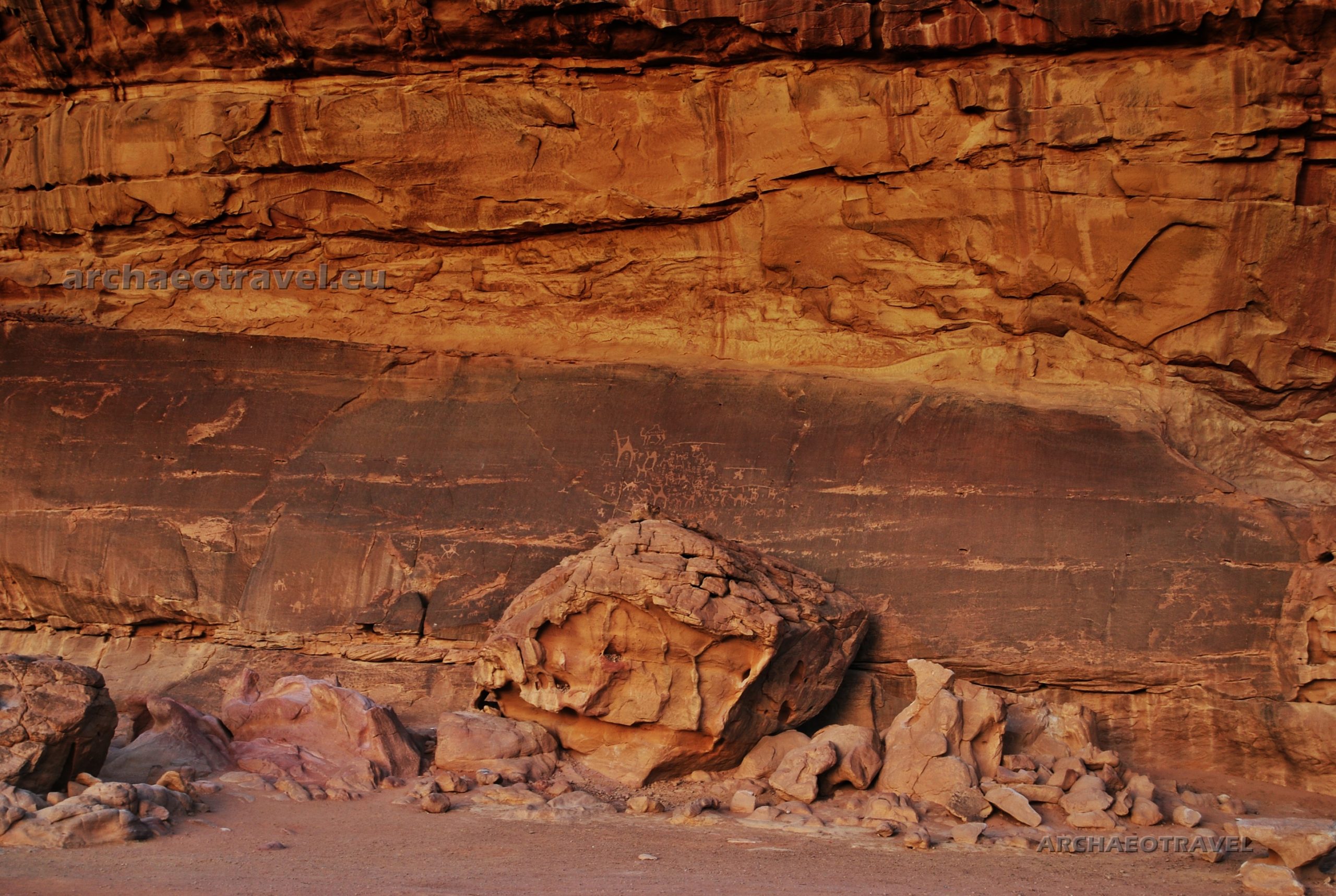
Maw of the underworld that holds the underground waters
I dived in to the abyss of the well and I found myself in a completely different world once again. Echoes of people’s voices heard above suddenly fell silent and I felt alone, as if on the threshold to the unknown, underwater realm, existing – as the Maya believed – parallel to the real one (Prager 2013:279).
It was ruled by dangerous deities, such as the rain Mayan god Chaak (Aztec’s Tlaloc), and dwelled by various mythical creatures being the gods’ helpers (Prager 2013:279; Brady 2013:299; Tuszyńska 2007:62-63; “Xibalba” 2020). Some of them personified significant forms of the landscape: mountains, caves and cenotes (Brady 2013:299). In Mayan inscriptions, scholars identify wide-open jaws of Centipede (Sak Baak Chapaata), symbolizing cenotes as the ‘maw of the underworld (or of the Earth Monster) that holds the underground waters’ (Ibid.:299; also see the drawing a: “Maw of the underworld from Pakal’s sarcophagous”. In:Schele and Mathews (1998). Drawing source: Ramos Ponciano M. E., Ball J. W. (2017). Not only cenotes, but also underwater lakes in caves, are the natural models of this mythical place, inhabited by both, animals, such as frogs, lizards, water snakes, scorpions, and more grotesque creatures, like gnomes, souls of the forest and short people, dwarfs (Prager 2013:279).
Divine dwarfs in cenotes
Dwarfs not only performed various administrative functions and entertained the ruler at pre-Columbian royal courts, but also played an important role in the mythology of the Maya, who believed in the classical and post-classical periods that the four dwarfs were tasked with raising the vault of heavens.
Cenote Ik Kil is one of main tourist attractions of Yucatan Peninsula. Photo by Matias Cruz (2014). Photo source: Free images at Pixabay.
The Olmecs also knew of the image of the four dwarfs supporting the sky, where dwarfs were equally pictured, like stone atlases, supporting the structure of the altar, possibly representing the vault of heavens (Prager 2013:278-279). The Maya even saw two dwarfs in the firmament, symbolizing undiscovered constellations (Ibid.:279). Midgets, as much as hunchbacks, cripples and albinos were viewed by the Maya and other pre-Colombian cultures as supernatural beings through their physical infirmities (Ibid.:278). They were all also regarded, like Maya rulers were, as messengers of the divine world and a means of contact with it (Ibid.:278). As such, the dwarfs are often depicted as companions of gods, including the sun and maize deities (Ibid.:279). This explains why in art, the Mayan kings considered divine, were also depicted in the company of midgets; the ruler performing religious rituals imitated the gods and became the center of the real world and the underworld (Ibid.:278).
Ruler attended by court dwarf. A photograph of a colorful ceramic vessel; origin unknown; late classical period, 600-900 AD; private collection (Kerr 1453). Court dwarfs performed many functions at the ruler’s court. In the depiction, one of them is kneeling in front of the ruler, holding a mirror, while another one below checks the quality of the food in the vessels and jugs or examines if it is not poisoned (Prager 2013:278). Photo source: Latin American Studies (2020) “Maya Dwarfs”. In: The Maya. Latin American Studies.
Mayans thus believed that dwarfs come from outside the real world and actually are divine and supernatural beings (Prager 2013:279). They dwell in the underworld or ‘place of fright’, Xibalbà, which is as much sacred as dangerous (Tuszyńska 2007:34,36; “Xibalba” 2020). In the Maya’s opinion, the boundaries and the portals to this world can be found in overgrown holes in the forest, dark caves, deep ravines, and also in shimmering water mirrors overgrown with dark green water lilies, or just in deep cenotes, like this one I was just swimming in (Tuszyńska 2007:36; Prager 2013:279). Such wells were perceived as symbolical corridors between the earthly land and underworld (Tuszyńska 2007:37).
More about dwarfs
The history of the Mayan dwarfs, however, does not end here; I have also read that among the Maya’s offerings found in the caves, there have been also found querns for producing corn flour, which was possibly related to the Mayan belief that the first world was inhabited by dwarfs, saiyam unicoob, who built the first stone cities (Tuszyńska 2007:26; Brady 2013:305). The first world was deprived of the Sun (Tuszyńska 2007:26). When it was finally created and shone for the first time, it turned the dwarfs into stone, and their images can now be seen in many ruins (Ibid.:26). The donors probably wanted to pay tribute to them by similar offerings (Brady 2013:305).
After the Maya, dwarfs took part in “a rite of passage in which [they] assist the soul of the [privileged] deceased into the domain of the dead, [the underworld], from which it would eventually be reborn in the royal lineage, [just as the maize god died in the underworld and resurrected. Similarly,] maize sprouts again in the cycle of nature’s renewal” Art (Institute Chicago 2020). This is possibly why dwarfs are often seen in art while accompanying the maize god (Prager 2013:279; Institute Chicago 2020).
Crunchy nachos and human bones
After one hour of swimming in the underworld, I woke up from a daydream, as if revitalized. I was sitting in one of the on-site restaurants. The waiter has just brought a basket full of crunchy nachos and a saucier of juicy guacamole. It was a pleasant feeling to join archaeology and mythology with a tourist attraction and delicious Mexican food.
‘Why did not you tell me?!’, my friend asked reproachfully, sitting at my table, and pulling a wicker basket with nachos towards her.
‘About what?’, I asked surprised.
‘That THEY pulled people down HERE in the water to sacrifice them!’, she explained. ‘But it is better I have found it out not earlier than I got into the water’, she added without waiting for my explanation.
The Samulá Cenote in Valladolid, Yucatán, Mexico. Photo by dronepicr (2015). CC BY 2.0. Photo source: “Cenote” (2020). In: Wikipedia. The Free Encyclopedia.
Indeed, the research of archaeologists confirmed the thesis that the Maya offerings were not only composed of products made of jade, shells, flint and ceramics, but there were also sacrifices of humans (Tuszyńska 2007:37; Brady 2013:305; Dzikowska 2013:201). Diego de Landa also mentions human offerings given by the pilgrims to the Cenote Sagrado in Chichén Itzá (Brady 2013:305). Since the arrival of the Conquistadors, stories have circulated about human sacrifice practiced by the Maya (Tuszyńska 2007:37). Chroniclers of that time mention that children and young women were thrown into the water (Tuszyńska 2007:37; Brady 2013:305). However, according to the researchers, the excavated human remains do not always indicate sacrifices (Tuszyńska 2007:37). In many cases it turned out that in most cases humans were thrown into the water after their death, and this concerned both men and women of a different age (Ibid.:37). It supports a hypothesis that the remains of ancestors and important personalities were thrown into the waters of the cenotes, because they symbolized the primeval ocean in the moment of the creation of the world (Ibid.:37). In this way, the dead were reborn to a new life (Ibid.:37).
Burials or human sacrifice?
There are many other hypotheses about human skeletons found in cenotes (Tuszyńska 2007:37). One of them states that they could be burial places (Ibid.:37). The best example of such a water cemetery is the Cenote Tankah (Quintana Roo), where the walls were marked by the Maya with glyphs of darkness and the planet Venus (Ibid.:37). Both glyphs are associated with night and death, but also with life and rebirth (Ibid.:37). Assuming that the cenotes were symbolic entrances to the world of the dead, Xibalbà, the hypothesis of natural burial chambers in cenotes is justified (Ibid.:37).
According to a related theory, human bodies were placed in cavities that were naturally hollowed in the walls of the well and emerged in periods of drought (Tuszyńska 2007:37; Dzikowska 2013:201). And droughts were actually the main reason for the human sacrifice to appease Chaak, the rain god (“Ik Kil” 2020). Such dry spells were the greatest in the ninth and tenth centuries AD., and when they finally passed away, the water flooded the bodies of the victims thus deposited (Dzikowska 2013:201).
In the Cenote Tankah, scattered bones belonging to one hundred and eighteen human skeletons were found (Tuszyńska 2007:37). Two hundred and fifty skeletons have been uncovered at Cenote Sagrado of Chichén Itzá (Dzikowska 2013:201). ItzáIk Kil cenote was equally sacred to the Mayans who used it for various offerings, including human sacrifice to their rain god, Chaak (“Ik Kil” 2020). Consequently, apart from numerous pieces of jewellery, archaeologists and speleologists have found human bones also in the deep waters of this cenote (Ibid.).
Cenote Chichi de los Lagos. Homun. Yukatan by Televisa Bicentenario. Source: Oleg Och (2011). In: Oleg Och Youtube Channel.
‘Next time, we are going to snorkel in the sea’, decided my friend, devouring the last nachos. ‘And I hope not to find any human bones’.
Touching history by accident
I smiled to myself. It is difficult not to touch the past in such places as Mexico, where the present is continuously being filtered through the ancient heritage, whose remnants are so tangible at each step taken by a modern visitor, even if they are quite unconscious of such significant ancient influences.
Featured image: Entrance to Dos Ojos Cenote, near Tulúm in Mexico. Photo by Dag Lindgren (2007). CC BY-SA 3.0. Image cropped. Photo source: “Sistema Dos Ojos“ (2020). In: Wikipedia. The Free Encyclopedia.
By Joanna Faculties of English Philology, History of Art and Archaeology. University of Silesia in Katowice, Poland; Cardinal Stefan Wyszyński University in Warsaw, Poland; University College Dublin, Ireland.
BIBLIOGRAPHY:
“Cenote” (2020). In: Wikipedia. The Free Encyclopedia. Available at <http://bit.ly/2L9bXVb>. [Accessed on 30th December, 2020].
“Ik Kil” (2020). In: Wikipedia. The Free Encyclopedia. Available at <http://bit.ly/3pyPobr>. [Accessed on 30th December, 2020].
“Sistema Dos Ojos“ (2020). In: Wikipedia. The Free Encyclopedia. Available at <http://bit.ly/354EZN7>. [Accessed on 2nd January, 2021].
“Xibalba” (2020). In: Wikipedia. The Free Encyclopedia. Available at <http://bit.ly/2JBW21v>. [Accessed on 2nd January, 2021].
Brady J. E. (2013). ”Odkrywanie ciemnych sekretów – archeolodzy w jaskiniach Majów.” Jawińska M. trans. In Majowie. Niezwykła cywilizacja. [Maya. Gottkonige im Regenwald]. Grube N., Eggenbrecht E., Seidl M. eds. Warszawa: Grupa Wydawnicza Foksal.
David (2020). “Cenote Ik Kil, Chichen Itza: Ultimate Guide (2020)”. In: The Whole World is a Playground. Available at <http://bit.ly/2WUdFfM>. [Accessed on 30th December, 2020].
Dzikowska E. (2013). Tam, gdzie byłam. Meksyk. Ameryka Środkowa. Karaiby. Wydawnictwo Bernardinum.
Free images at Pixabay. Available at <https://bit.ly/3fTQX0u>. [Accessed on 30th June, 2021].
Latin American Studies (2020). “Maya Dwarfs”. In: The Maya. Latin American Studies. Available at <http://bit.ly/3rKBQvn>. [Accessed on 1st January, 2021].
Oleg Och (2011). “Cenote Chichi de los Lagos. Homun. Yukatan by Televisa Bicentenario”. In: Oleg Och Youtube Channel. Available at <https://bit.ly/3rFAfXS>. [Accessed on 30th December, 2020].
Prager Ch. (2013). ”Nadworne karły – towarzysze władców i wysłannicy podziemnego świata.”Jawińska M. trans. In Majowie. Niezwykła cywilizacja. [Maya. Gottkonige im Regenwald]. Grube N., Eggenbrecht E., Seidl M. eds. Warszawa: Grupa Wydawnicza Foksal.
Ramos Ponciano M. E., Ball J. W. (2017). “Eccentric Caches of Buenavista del Cayo: Contextual Analysis and Cosmological Significance“. Thesis for: M.A. Advisor: Joseph W. Ball; Jennifer Taschek; Seth Mallios. SDSU Mopan-Macal Triangle Archaeological Project. In: ResearchGate. Available at <http://bit.ly/3o9Nde6>. [Accessed on 1st January, 2021].
Tuszyńska B. (2007). ”Mitologie świata: Majowie”. In: Rzeczpospolita. Kraków: Drukarnia Narodowa SA.
In the late afternoon, we found ourselves on the threshold of Wadi Rum. Known also as the Valley of the Moon (“Wadi Rum” 2020), this magic land is located in the southern part of Jordan, close to the border with Saudi Arabia, and about forty kilometres east of Aqaba (Chabińska-Ilchanka et al. 2015:265).
Today, Wadi Rum is a home to Jordan Bedouins, who are Arab semi-nomadic people inviting visitors to their fairy-tale kingdom. One of the most famous guests to Wadi Rum was undoubtedly T.E. Lawrence (1888–1935), also known as Lawrence from Arabia (Biography 2014-2015). He was a British military officer and archaeologist greatly involved in Middle Eastern affairs and in the Great Arab Revolt (Ibid.). In the years 1917-1918, Lawrence travelled through Wadi Rum several times describing his enchantment at the entrance into the Valley as follows (“Wadi Rum” 2020):
“The hills on the right grew taller and sharper, a fair counterpart of the other side which straightened itself to one massive rampart of redness. They drew together until only two miles divided them: and then, towering gradually till their parallel parapets must have been a thousand feet above us, ran forward in an avenue for miles. The crags were capped in nests of domes, less hotly red than then body of the hill; rather grey and shallow. They gave the finishing semblance of Byzantine architecture to this irresistible place: this processional way greater than imagination.”
Lawrence, T.E. 1935:351
Iram of the pillars
We climbed onto one of the three off-road cars and started our journey through sandy and rocky oranges of the desert. The sun was still hanging high but the night falls there in the nick of time. It automatically brings a sudden cold that replaces the daytime sun heat. In such conditions warm clothes are a must.
In its fascinating past, Wadi Rum must have been inhabited by many various cultures whose distinctive traces are still visible today (“Wadi Rum” 2020).
It is likely that it receives its name from Iram of the pillars, which is usually described as a lost city, region or tribe mentioned in the Quran (Ibid.). Cut into the sandstone and granite rock, it includes an area of approximately seventy-four thousand hectares of amazing landscape, distinguished by extraordinary natural and cultural value (Chabińska-Ilchanka et al. 2015:265; “Wadi Rum” 2020). The natural environment consists mainly of the typical though stunning desert landscape with a varied topography (Chabińska-Ilchanka et al. 2015:265). There are sandy plains, cliffs, gorges and even caves and rocky landslides (Ibid.:265). An interesting diversification of that landscape are natural rock formations in the form of arches, bridges and arcades (Ibid.:265).
Petroglyphs
Within this area, groups of pre-historic petroglyphs have been found at several sites (Chabińska-Ilchanka et al. 2015:265). The rock drawings most likely come from twelve thousand years ago and prove the existence of settlement in this desert area since prehistoric times (Ibid.:265). Due to cultural landscape and its natural values, in 2011 the protected area of Wadi Rum was entered on the UNESCO World Cultural and Natural Heritage List (Ibid.:265).
Among the rock carvings that were found in Wadi Rum, there are twenty-five thousand figurative representations and twenty thousand characteristic signs looking like inscriptions that could constitute the first attempts to create a writing (Chabińska-Ilchanka et al. 2015:265; Mohammad 2015). The former usually represent people and animals, whereas among the latter, there are North-Arabian scripts: Nabatean, Islamic (Kufic), Arabic and mostly the so-called Thamudic inscriptions (Chabińska-Ilchanka et al. 2015:265; Mohammad 2015; “Wadi Rum” 2020; “Thamudic” 2020).
The Thamud
The Thamud belonged to ancient Arabian tribes occupying the north-western Arabian peninsula between the late eighth century BC and the fourth century AD (“Thamud” 2020). “They are mentioned in contemporary Mesopotamian, Classical, and Arabian sources” (Ibid.). It does not mean, however, all the petroglyphs from Wadi Rum were made by that tribe (“Thamud” 2020; “Thamudic” 2020). Actually, the name Thamudic was invented by nineteenth-century scholars for major part of inscriptions covering a huge area from Syria to Yemen (“Thamudic” 2020). “[Such inscriptions belong to a large group of] Ancient North Arabian (ANA) alphabets which have not yet been properly studied” (Ibid.).
The Nabatean
Many petroglyphs from Wadi Rum, however, are ascribed to Nabateans, an ancient nomadic Arab people who emerged between the fourth and second century BC and held their independence till the annexation of their territory to the Roman Empire in 106 AD (“Nabataeans” 2020). Nabateans are also said to be creators of Petra and although they surely inhabited the site, there is much doubt regarding the original builders of the city. It is, however, another story …
In tranquil and shaded Ain Shalaaleh, on the south side of Wadi Rum, there is the head of a Nabatean rock-cut aqueduct, which is close to Rum village and the remains of the Nabatean temple (Mohammad, “Confusion (….)” 2015).
Lawrence wrote that “[on] the rock-bulge above were clear-cut Nabathaean inscriptions, and a sunk panel incised with a monogram or symbol. Around and about were Arab scratches, including tribe-marks, some of which were witnesses of forgotten migrations: but my attention was only for the splashing of water in a crevice under the shadow of the overhanging rock. I looked in to see the spout, a little thinner than my wrist, jetting out firmly from a fissure in the roof, and falling with that clean sound into a shallow, frothing pool, behind the step which served as an entrance. Thick ferns and grasses of the finest green made it a paradise just five feet square.” (Lawrence 1935, p.355).
Images for communication
“Petroglyphs are images created by removing part of a rock’s surface by incising, pecking, carving, and abrading with something like a stone chisel. Inscriptions are characters [created just] in the same way as petroglyphs. Most petroglyphs [in Wadi Rum] were made on cliff faces, [large] rocks, and boulders” (Mohammad 2015).
The content of the petroglyphs and other artifacts found in the area are a source of knowledge about the social change and lifestyle of prehistoric desert tribes in the Arabian Peninsula (Chabińska-Ilchanka et al. 2015:265). “The illustrations of people show human figures holding bows and arrows” (Mohammad 2015). By their side, there is a large number of drawings representing animals, such as camels, ibexes, and horses (Ibid.). “[Alongside] all these figures are [enigmatic] symbols like lines and circles. Experts [assume] that they are instructions and messages left by [prehistoric] people [to communicate]. Some of them [may be] about giving directions to find hidden springs, [whereas others] about updating each other on things like who visited the area last. Altogether, these engravings [are believed] to provide an insight into the development of human thought [as] a pattern of pastoral, agricultural, and urban human activity” (Ibid.).
Scorpions were already asleep
We got off the car and approached one of the multiplied rocks. Its reddish surface was carved with intriguing images.
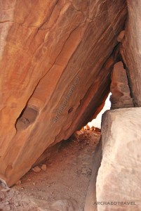
At first sight I could discern some animal figures, mostly camels. Yet some were rather difficult to guess. Whereas some camels were depicted in movement with funny forked tails, others were standing still and the one had an inscription inside its body. The biggest one with its long neck looked like a giraffe. Only its single visible hump indicated that it was a dromedary after all. There were also a few primitively drawn human figures with outspread arms and legs, who may stand for Neolithic members of a nomadic tribe. Those were quite similar to Neolithic human representations from northern Africa. Most intriguing, however, were strange symbols depicted around the recognized characters – one looked like a mountain peak – and inscriptions accompanying the whole scene. ‘I wish I could stay here longer and make drawings’, I thought while taking a thousand of pictures. Pushed by curiosity and in search of further images, I slipped under the rock ledge above the carvings. After a while I found there some traces of petroglyphs but mostly fragmented inscriptions. ‘You are a peeping type of a person’, said our Bedouin guide smiling. ‘It’s good that scorpions are already asleep’, he added.
It was pitch-dark when we finally reached back our camp. The electrical lamps illuminated a row of large tents waiting for tired visitors. We had just arrived to Jordan and Wadi Rum turned out to be our gate to its treasures.
By Joanna Faculty of History of Art and Archaeology Cardinal Stefan Wyszyński University in Warsaw, Poland UniversityCollege Dublin, Ireland
BIBLIOGRAPHY:
“Nabataeans” (2020) Wikipedia. The Free Encyclopedia. Available at <https://bit.ly/3nNAs8u>. [Accessed on 22nd November, 2020].
“Thamud” (2020) Wikipedia. The Free Encyclopedia. Available at <https://bit.ly/3lWe8cf>. [Accessed on 22nd November, 2020].
“Thamudic” (2020) Wikipedia. The Free Encyclopedia. Available at <https://bit.ly/3950pfL>. [Accessed on 22nd November, 2020].
“Wadi Rum” (2020) Wikipedia. The Free Encyclopedia. Available at <https://bit.ly/3kS4OoI>. [Accessed on 22nd November, 2020].
Biography (2014-2015) “T.E. Lawrence”. In: Biography.com. Available at <https://bit.ly/3kOf69e>. [Accessed on 22nd November, 2020].
Chabińska-Ilchanka, E., Dylewska K., Horecka K., Jaskulski M., Kastelik M. M., Łatka M., Ressel E., Willman A., Żywczak K. (2015) Niezwykłe miejsca świata. Warszawa: Wydawnictwo SBM Sp. zo.o.
Lawrence, T.E. (1935) Seven Pillars of Wisdom. Garden City: Doubleday, Doran & Company, Inc.
Mohammad, F. (2015) “Confusion about the Real Lawrence Spring Cleared”. In: Wadi Rum. Nomads. Available at <https://bit.ly/2J58ZA0>. [Accessed on 22nd November, 2020].
Mohammad, F. (2015) “The Petroglyphs and Inscriptions of Wadi Rum”. In: Wadi Rum. Nomads. Available at <https://bit.ly/36VBEjz>. [Accessed on 22nd November, 2020].
For a good while, I could not gather my thoughts as I stood in the vestibule of the Throne Room and looked deeper into its abyss. The name of this part of the so-called Palace of Knossos comes from the limestone throne found there, which has surprisingly survived in its entire form and which is still in the same location where Evans discovered it and where it was probably used in the past (Łogiadu-Platonos date unknown:60). Although it does not resemble the royal Egyptian thrones of the pharaohs or those of the ancient East, the archaeologist was convinced that he had come across a Cretan royal mansion where King Minos had once been enthroned (Gregor 1997:16).
Since then, however, various hypotheses have been made about the Throne Room of Knossos (Gregor 1997:16).
Kefalia Hill
Arthur Evans began excavations on the Kafala Hill – at the site of the the so-called palace at Knossos – on 23rd March, 1900 (Witcombe 1995; Archaeological Institute of America 2017). An early discovery, made on 30th March, was a great number of clay tablets inscribed in Linear B script in the Room of the Chariot Tables (Ibid.). The most significant discovery, however, turned out to be the Throne Room complex (Ibid.). During the following months, Evans’s group unearthed a series of mysterious rooms along the west side of what later was known as the Central Court (Ibid.).
Grandstand fresco from the palace of Knossos (reconstruction). Source: Pinterest (2020)..
Unexpected discovery
During this first season of excavation at Knossos, the area between the Throne Room and the Room of the Chariot Tables was uncovered (Witcombe 1995; Archaeological Institute of America 2017). It included the Room of the Tall Pithos and a small room with two open, and empty, cists or vats in the floor (Ibid.). At the time of their discovery, the cists were of a very little interest … (Ibid.).
Temple repositories
Three years later, in 1903, it was noticed that the pavement around the cists was sagging and upon investigation, two much larger stone-lined cists, or repositories, were discovered beneath the floor (Witcombe 1995; Archaeological Institute of America 2017). This area was called the Temple Repositories of the Snake Goddess Sanctuary at Knossos (Witcombe 1995; Castleden 2000:80-81; Archaeological Institute of America 2017). The Tripartite Shrine depicted in one of the Grandstand Fresco may have once been its façade (Witcombe 1995; Archaeological Institute of America 2017). Sir Arthur Evans found a large quantity of amazing objects there, probably deposited just after the huge earthquake, around 1700 BC. (Ibid.).
Excavation of the temple repositories, from Sir Arthur Evans, The Neolithic and Early and Middle Minoan Ages (London: Macmillan, 1921), p. 465 (Universitäts-Bibliothek Heidelberg).Source: German (2018).
“Duncan Mckenzie found, on top, a large quantity of vases […] tightly packed together. Then, about a metre down, he found seal impressions, large quantities of painted sea shells, imitation shells and flying fish, fruit and flowers made of faience, beads, faience chalices with sacred tree motifs, decorative inlays, objects made of bone and ivory, gold leaf, a finely polished but broken marble cross [and] two beautiful faience plaques of a goat with her kids and a cow with her calf” (Castleden 2000:81).
Ritually killed?
The most spectacular finds, however, were the broken pieces of at least three female faience statuettes (Witcombe 1995; Archaeological Institute of America 2017; German 2018). “Vast numbers of shells accompanied the terra-cotta figures, along with votive robes for the statues” (Johnson 1990:144). They all were actually represented opulently dressed with two of them with snakes (Witcombe 1995; Archaeological Institute of America 2017; German 2018). The third one lacks the upper part so it is difficult to say if she held the snakes as well but it is highly possible (Ibid.). “One of the [figures holding snakes] found in the East Repository had been [also] broken before it was sealed up in the vault; a matching fragment of it was found in the West Repository. These and other pieces of cult furniture may have been deliberately, ritually killed [by their depositors] by breaking before being sealed up in the large repositories as a re-foundation offering. After they were filled and closed, the repositories were replaced by two new and smaller [ones]” (Castleden 2000:81).
Objects from the temple repositories f Knossos, just after its discovery in 1903. Evans, A.J. (1921-35). The Palace of Minos – Volumes 1-4. Source: “Minoan Snake Goddess Figurine” (2020). In: Wikipedia. The Free Encyclopedia.
“The most significant thing about the temple treasure is that it hints at the sort of cult activities that may have been conducted in the surrounding chambers of the Snake Goddess Sanctuary” (Castleden 2000:81).
Snake Goddesses’ epiphany and her Votary
The larger statuette (left) stands some thirty-five centimetres high and possibly depicts a female idol, representing the Snake Goddess, her Epiphany or the Great Priestess performing religious rituals (Witcombe 1995; Archaeological Institute of America 2017). She is wearing a tall hat, an embroidered bodice and a skirt with a short apron (Witcombe 1995; Archaeological Institute of America 2017).
“Her omnipotence is expressed through a triple tiara topped […] by a snake’s head, [the] bodice, a laced corset exposing her full breasts, suggests her nourishing aspects. The skirt is bordered with the sacred net pattern and partially covered by a short double apron edged with the wave design. The figurine’s most striking features are her staring eyes, black and hypnotic. The eyebrows are sculpted in relief to enhance the mantic expression. Hair hair, cut short in front, falls down her back to her waist. Large ears, quite out of proportion, are a feature noted in other Cretan goddesses of the period” (Johnson 1990:142). Probably three snakes are swirling around her body (Witcombe 1995; Archaeological Institute of America 2017). One is draped around her neck so that it hangs well down her back with its bulk slithering along both of her arms (Ibid.). She holds the snake’s head in her right hand and the tail in her left (Ibid.). Two other snakes appear to slither down her body from the top of her headdress, gliding past her breasts to intertwine their heads just below her waist (Ibid.). All of them “twine [around the faience woman] as if offering life or death” (Johnson 1990:142).
The Snake Goddesses and her Votary from the palace of Knossos, c. 1600 B.C.E., faience, 34.2 cm and 29.5 cm high (Archaeological Museum of Heraklion, photo (modified): Jill_Ion, CC BY-NC-ND 2.0; modified). Source: German (2018).
The smaller figure (far right), which is about twenty centimetres tall, was found with the head and part of the left arm missing (now reconstructed) (Witcombe 1995; Castleden 2000:81-82; Archaeological Institute of America 2017). At the time of being found, she grasped a small snake in her surviving outstretched hand and presumably there had been another one in the right one (Johnson 1990:143; Witcombe 1995; Archaeological Institute of America 2017). The snake’ “size and distinctive markings identify [it] as [a] sacred [adder]” (Johnson 1990:143). Evans found a small fragment of what he took to be her headdress, a circular crown decorated with raised medallions (Witcombe 1995; Archaeological Institute of America 2017). There was a small rivet hole in the top that matched exactly with another fragment representing the small seated figure of a feline, perhaps a lioness, and the figure was restored on that basis (Ibid.). “The restoration of the Snake Goddess was done by the Danish artist Halvor Bagge together with Evans. Their contribution to the figurine was the creation of a matching arm and stripy snake, the head of the goddess, and the placement of the hat and cat […] on her head, [composed of] separate faience pieces found in the Temple Repositories […]” (German 2018).
The Snake Goddess prior to restoration by Evans, from Angelo Mosso, The Palaces of Crete and Their Builders (London: Unwin, 1907), p. 137 (University of Toronto Libraries). Source: German (2018).
“The nubile figure of the smaller goddess is robed in the same fashion as the more matronly figure. A tight-fitting jacket exposes her breasts. Her bell-shaped skirt hangs from the waist in seven flounces, and her apron is covered with the cross-hatched net pattern. Like the larger [figure, the smaller’s] skirt covers her feet, a mark of divinity” (Johnson 1990:143). Evans believed the larger figure to be the Goddess herself or a High Priestess as her epiphany, while the smaller was perhaps a lesser and younger priestess or a votary (Witcombe 1995; Castleden 2000:82; Archaeological Institute of America 2017).
Two Snake Goddesses from the palace of Knossos, c. 1600 B.C.E., faience, 34.2 cm and 29.5 cm high (Archaeological Museum of Heraklion, photo: Jill_Ion, CC BY-NC-ND 2.0; modified). Source: German (2018).
The figurines must have been created long before the time of the earthquake (Witcombe 1995; Archaeological Institute of America 2017). Nevertheless, they are usually dated back to the time of their destruction (Ibid.). “[Now] reconstructed and deservedly among the most famous and memorable relics of the Minoan culture, [they both show] how the Minoan Snake Goddess was visualized [and] her High Priestess ritually and ecstatically transformed into an epiphany of the goddess” (Castleden 2000:82-82).
The Palace of Knossos is not a palace
As Sir Arthur Evans excavated the magnificent ruins at Knossos, he grew more certain that this was a palace of King Minos and home of the legendary labyrinth (Lilley 2006). He even believed that he had found a royal throne (Ibid.). However, new revelations about Minoan religion and language are transforming a modern understanding of those people (Ibid.). Some archaeologists believe that these buildings are not a palace (Ibid.). Instead they see the Daedalus’ labyrinth or a temple [or both] to harness the chthonic and celestial powers of the divine (Castleden 2000:70-76; Lilley 2006; ).
The Throne Room
Rodney Castleden thinks that “[the] Throne Room has an oppressive, claustrophobic quality that is often missed in photographs” (Castleden 2000:77). I share his opinion. “Windowless and low-ceilinged, approached by way of a deep anteroom that itself is depressed four steps below the level of the Central Court, the room has an almost subterranean quality” (Ibid.:77). Such a character of the Room was also expressed by the colour of the floors and pillars (Ibid.:77). They were pained red (Ibid.:77). The colour itself was associated with sacrificial blood and by extension also with the underworld (Ibid.:77). “The red floor panel was apparently the centre of the religious rituals in the Throne Sanctuary and the manifestation of the deity on the throne itself was their focus” (Ibid.:77).
The throne was made of gypsum and, unlike flanking it benches, it was surely intended as a seat (Castleden 2000:77). Surprisingly enough, “it does not face the doorway, but looks across the width of the room towards the half-hidden sunken adyton (holy of holies), [which is also referred to as the lustral basin]” (Ibid.:77). Its design particularly indicates its chthonic character and purpose, and its setting visibly relates it to the throne itself (Ibid.:77). Some scholars even interpret it as the walled pit used for holding sacred snakes (Gregor 1997:17).
“The whole complex of chambers, sixteen in all, [with the adyton included], was evidently designed as a self-contained unit within the temple building” (Castleden 2000:78). It may have been dedicated to the Snake Goddess as her major attribute has been specifically linked to the powers coming from the underworld.
Priestess of the light and darkness
In 2001, the archaeologist, Dr Sandy McGillivray realized that each of the doorways in the Throne Room is aligned with the rising sun on key days in the calendar (Lilley 2006).
The Vase of Zakros. Museum of Heraklion, Crete. CC BY-SA 3.0.; 2012. Source:Source: “Zakros” (2020). In: Wikipedia. The Free Encyclopedia.
‘What we’re looking at here is a solar temple’, he claims (Lilley 2006). Accordingly, like the Egyptians, the Minoans may have worshiped the changing cycles of the Sun, the Moon and the stars (Ibid.). Light has always been born from darkness and “[the] adyta were certainly places to descend into […] dark and secret places for mystic rituals, places where the subterranean deities might be invoked, places for individual initiation” (Castleden 2000:78). In the darkness of the adyton, the whole ceremony of the Throne Room may have started with the throne as its focal point. “What we have here is essentially a theater of the senses’, says Dr McGillivray (Lilley 2006). “You can start off with complete blackness and then you can fling open these doors at that [very] moment of sunrise and experience [the] beginning of something new. And in the winter, the Sun comes through on the winter solstice and illuminates the throne” (Ibid.).
Peak Sanctuary re-creation
“The nature of the frescoes [of the Throne Room themselves] suggests an attempt was being made to re-create [there] the wild landscape of the mountain tops. The peculiar wavy shape of the throne […] is a representation of a mountain peak; a rhyton from the temple at Zakro shows a very similar form to indicate the summit of a mountain rising behind an elaborately designed peak sanctuary” (Castleden 2000:79).
The Vase of Zakros. Museum of Heraklion; detail showing the outlines of the throne imitating a mountain peak (between the wild goats’ heads), Crete. CC BY-SA 3.0.; 2012. Source:Source: “Zakros” (2020). In: Wikipedia. The Free Encyclopedia.
Accordingly, “[the] intention of the Throne Sanctuary […] was to honour the same deity or deities that were honoured in the peak sanctuaries by a symbolic re-creation of the peak setting” (Castleden 2000:79). This was mostly a domain of the Mountain Goddess, and the peak dominated by her presence was usually interpreted as a form of her throne (Żak-Bucholc 2005). The latter was also a symbolical representation of the goddess herself (Żak-Bucholc 2005; see Image of the Goddess: between Matriarchy and Patriarchy).
Who sat on the Throne?
“But which god or goddess was being worshiped or appeared to in the Throne Room is far more difficult to say” (Castleden 2000:79). Who then would have sat upon the throne? (History Channel 1980s). Was it used by a king to hold court or did snake princesses practice their rituals of sacrifice there? (Ibid.). Who may have worn the Isopata Signet Ring illustrating rituals led by women? (Ibid.). Was it the privilege of royal or priestly dignity? (Ibid.).
“It was on 13th April 1900 that Evans’ workmen started uncovering the north wall of the Throne Room with its palm tree fresco fragments and the throne itself” (Castleden 2000:43). The Throne Room with its seat, still perfectly intact, is the oldest ever found in Europe dating back to the fifteenth century BC. (circa 3500 years old) (“Throne Room” 2020; see Castleden 2000:31-32,43-44). “[It] seemed to provide Evans with the solid proof of kingship that would support his palace interpretation, but it also provided him with less welcome evidence of religious use” (Castleden 2000:77).
From one side, there is evidence suggesting the existence of a real King Minos; later on, archaeologists found an inscription in an ancient language that may even mention the King by name (Cassel, Conway 2009). ‘In the archives of Knossos there were stone tablets which have inscribed on the words which looked to be like the name of King Minos’, says the author, Tom Stone (Ibid.). Some scholars, however, claim that the word ‘Minos’ does not stand for the name of a particular king but refers to the common title of the monarchs of the Minoans (Castleden 2000:171-172; see Santarcangeli 1982). Also “the strength of the Greeks’ belief in King Minos suggests that there were kings in bronze age Crete” (Castleden 2000:171). These clues suggest the King may have actually lived but the most intriguing connection to the ruins in Knossos appears on another tablet found at the site (Cassel, Conway 2009). “On tablet Gg 702, the inscription [written in the Linear B] refers to an offering made to [the so called Mistress or Lady or Potnia of the Labyrinth]” (Castleden 2000:107; see: Cassel, Conway 2009). So there is in writing not only a direct reference to the Labyrinth, described by Greeks in the Myth of Minotaur, but also a unmistakable connection between the Palace of Knossos and the Labyrinth itself (Cassel, Conway 2009).
Ariadne at the threshold of the Labyrinth. Shot from the documentary Cassel C., Conway J. (2009) The Labyrinth of the Minotaur. Clash of the Gods, Season 1, Episode 4. Dreamaker Productions; KPI.
“[The word ‘Potnia’ [itself] was [long] in use in the classical period as an honorific title in addressing women of rank, such as queens, goddesses and mothers; it seems to have had the same flavour of archaic deference as the phrase ‘my lady’. [It] appears again and again as [the main female title referring to the Minoans’ goddess]. Hers, probably, was the double-axe symbol that [is found] at so many Minoan sanctuaries on Crete, but possibly the pillar and the snake were her symbols too. [Truly], the snake may particularly have made a natural symbol for the chtonic, Earth-mother aspect of Potnia” (Castleden 2000:107). Are then the faience female statuettes with snakes linked to the cult of Potnia, and so to the Lady of the Labyrinth?
Mistress of the Labyrinth
Some authors believe, there was a living epiphany of Potnia in Knossos, as much as it is illustrated by the faience figurines (Cassel, Conway 2009). Her identity is, however, an intriguing mystery (Ibid.). Experts believe it was a woman of great importance in the palace, a High Priestess or even the king’s daughter who held this title (Ibid.). In the myth, the King Minos’ daughter was Ariadne and she plays an important role in the myth (Ibid.). ‘We do not know who the Mistress of the Labyrinth was’, says Stone (Ibid.). ‘But it could have been Ariadne in as much as she was entitled to be the priestess of the temple because she was the first daughter of King Minos’ (Ibid.).
“Harriet Boyd, an American pioneer archaeologist […], was at Knossos when the Throne Room was opened up. She described in her diary how Evans straight away named the stone seat ‘the Throne of Ariadne’. The throne’s broad moulded seat, Evans explained, was more likely designed for a woman’s hips than a man’s” (Castleden 2000:43-44).
Sir Arthur Evans, 1911, in Knossos. Source: German (2020). In: Khan Academy.
For this reason it happened “he […] referred to the stone seat as ‘Ariadne’s throne’ and the sunken area opposite as ‘Ariadne’s bath’. […] But the association of the throne with Ariadne did not lead Evans anywhere, evocative though it was. [On the other side], Evans sometimes referred to the Throne Room as ‘King Minos’ Council Chamber’ to get round this problem. Even so, that initial inspiration witnessed by Miss Boyd, that the throne was Ariadne’s persisted” (Castleden 2000:44). As a matter of fact, “Evans gave different impressions about the throne on different occasions, [calling it either Ariadne’s or King Minos’ seat]. The accuracy of the name was perhaps unimportant to [him]. What seemed to have mattered most to [the archaeologist] was the names evoked the right response in the visitor, that he or she should feel the place to be a great palace and connected with glittering and exotic names from [the] Greek myth” (Ibid.:44-45).
Solar Virgin
According to the Greek myth, Ariadne is a Cretan princess, the daughter of King Minos and his wife Pazyfae, and the half-sister of the monstrous hybrid, Minotaur (Kowalski, Krzak 2003:24). Ariadne enters the mythical scene with the arrival of Theseus in Crete, who is intended together with his Athenian companions as a sacrificial offering to the Minotaur living in the Labyrinth (Ibid.:24). After falling in love with the hero, the girl reveals him the secret of how to leave the Labyrinth, and when he is saved she decides to abandon her home island by his side (Ibid.:24). One version of the myth tells of Ariadne’s breakup with Theseus; reportedly he abandons her on the island of Dia (now Naxos), where she eventually marries Dionysus (Ibid.:25-26). Thus, the meeting with the hero is only a short-lived episode in her life and is only a transition to the essential part of her divine destiny alongside Dionysus – the regenerating god par excellence (Ibid.:26). In this context, Ariadne was seen as a wild goddess, “associated with untamed landscape and consorting with wild beasts” (Castleden 2000:107), as much as it is illustrated by the found female figures.
Ariadne as the Lady of the Labyrinth. Shot from the documentary Cassel C., Conway J. (2009) The Labyrinth of the Minotaur. Clash of the Gods, Season 1, Episode 4. Dreamaker Productions; KPI.
In the Greek tradition, Ariadne was considered a solar virgin, a daughter of the sun and a spring maiden (Kowalski, Krzak 2003:25). Moreover, in Crete her name meant radiant and luminous (Ibid.:25). The Sun in its daily and annual journey illustrates the mystery of the resurrection, hence Ariadne was a symbol of rebirth (Ibid.:25). As such, she is the goddess of life, love and death (Ibid.:25). If she was a priestess in Knossos, she must have led the revival cult; it was finally believed that she disappeared annually and reappeared in the spring (Ibid.:25-26).
Ariadne’s guideline through the darkness
As Theseus goes deeper and farther, and with each step he comes closer to death at the bottom of the abyss, at the center of the maze, Ariadne is a ‘potential opportunity’ for him to see the light again (Kowalski, Krzak 2003:26).
Isopata Signet Ring from Knossos, showing some sort of ritual being performed by priestesses. Source: Tausch (2012). In: Wikidata.
The hero who reaches the end of death and kills the Minotaur would never have escaped from the dark Labyrinth if not for Ariadne’s help (Kowalski, Krzak 2003:26). The myth is therefore a story of rebirth, of leaving the Labyrinth in a physical and mystical, literal and figurative sense (Ibid.:26). On the threshold of the Labyrinth, in whose deepest recess lurks a mortal monster, stands Ariadne, the Lady of the Labyrinth (Ibid.:26). She offers the hero a ball of thread and holds its end in her hand as if she held the hero’s destiny (Ibid.:26). In this context, Ariadne personifies and combines two aspects: chtonic and solar, which are also closely intertwined in human life by death and rebirth (Ibid.:26). The Throne Room seems to illustrate this mystery, which is also well revealed by the Greek myth.
Ariadne on the Throne
Like chthonic powers, out of the underground depository of the Snake Goddess Sanctuary came the figures looking like Minoan deities or their priestesses (Lilley 2006). “[Snakes] characterize [their] domination of the underworld” (Johnson 1990:143). Such women apparently controlled religious life and there are scholars who believe that the gypsum throne at Knossos was occupied not by a king but by a priestess (Ibid.). ‘Whoever [sat] on that throne [was] basically being illuminated […] on the day when the Sun is reborn’, says Dr. McGillivray (Ibid.). Still he believes that it was rather a High Priestess who sat there to celebrate the rebirth of the Sun and re-forge the Minoan bond with nature (Ibid.). It is also likely that she was “mysteriously transformed by ritual into an epiphany of a deity (Castleden 2000:82).
Snake Goddess from the palace at Knossos, c. 1600 B.C.E., faience, 29.5 cm high (Archaeological Museum of Heraklion, photo: Zde. CC BY-SA 4.0). Source: German (2018); Joy of Museums Virtual Tours (2020).
The female figurines found at Knossos themselves suggest a strong cult of the snake deity in the Throne Room (Lilley 2006). Not only is the snake chthonic in its character but also did it appear as a symbol of the renewal coming with the rising Sun. As such it perfectly illustrates the opposite but co-substantiating one another powers of Ariadne. The presence of the snake imagery is also reinforcing the idea that the Knossos palace was actually a temple and that it was led by the Lady of the Labyrinth (Ibid.). Yet [its] size and evident […] seems to leave little room for a king. It is tempting to see King Minos as forever living in the shadow of the High Priestess of the Labyrinth, just as the worshipful Velchanos, Minoan male deity], always lived in the shadow of Potnia. The king may have been a puppet of the priestesses, dependent on them for the divine validation of his reign and perhaps even dependent on them for material sustenance; a share of a large tribute income of the Labyrinth may have been diverted discreetly into the king’s coffers” (Castleden 2000:172).
Women superior to men?
Apart from priestesses, who are believed to have stood at the forefront of the Minoan prosperous society, these were apparently Minoan women who enjoyed significant influence and independence (Mitchell 2011). The legal code found in Crete testifies that Minoan women had more marital rights than wives in other societies of that time (Ibid.). In the event of divorce, they could even order the return of the dowry (Ibid.). And only men were punished for adultery (Ibid.).
The Sacred Grove miniature fresco. Source: Antiquated Antiquarian (2015).
Such a high status of women and their religious leadership is also highlighted by the Minoan art. In the Grandstand or the Sacred Grove frescoes, there is a group of women “who are obviously the [significant] figures. [On the other side], there is still no sign of Evans’ king and no sign of any male officials” (Castleden 2000:116; see 54-55).
The presiding spirit of the Minoan Golden Age
The presiding spirit of Minoan Crete in its Golden Age was undoubtedly the Snake Goddess, the Minoan icon of the feminine power (Hughes 2004). Together with her diminutive companion, often described as a votary, the figurines are both beautifully attired but even their fine craftsmanship cannot disguise the fact that something elemental and very wild is hiding behind their elegant posture (Ibid.). The goddess’ fierce, wide-eyed stare is matched by her votary’s concentration; simultaneously, the gigantic snake grips her in a protective embrace from her slender waist right up to the tip of her headdress (Ibid.).
Hughes B. “The Snake Goddess”. In: Archer M, Kirby T. (2004) The Minoans. The Ancient Worlds: Episode 3 (fragment). Source: Higging (2018). In: Youtube.
The Minoan world was undoubtedly governed by such potent and vindictive powers as personified by the Snake Goddess (Hughes 2004). They could not be understood only placated (Ibid.). “For all the Goddess’ glamour and sexual power this is the deity who feeds off respect and fear and not love” (Ibid.). “Her fearsome expression is a reminder of the volcanic eruptions, tidal waves, and earthquakes that destroyed the temple-palaces on more than one occasion. The greatest eruption ever known is that of the volcano of nearby Thera, [today Santorini]. It blew up the island in a terrible holocaust […] that probably [began the destruction of] the Minoan civilization” (Johnson 1990:143; see: The World Ended When Gods Turned against the Minoans).
Here on Crete, although separated by millennia from the Minoans, I felt closer to the ancient mysterious forces, hidden in the hypnotic gaze of the Snake Goddess and Ariadne’s shining smile, indicating the exit from the Labyrinth’s abyss.
Featured image: Lesser figure of the Snake Goddess, priestess of a votary from the palace at Knossos (detail), c. 1700-1600 B.C.E., majolica, 29.5 cm high (Archaeological Museum of Heraklion, photo: Zde, CC BY-SA 4.0). Source: German (2018).
By Joanna Faculty of History of Art and Archaeology Cardinal Stefan Wyszyński University in Warsaw, Poland UniversityCollege Dublin, Ireland
BIBLIOGRAPHY:
Antiquated Antiquarian (2015) “The Minoans: Frescoes”. In: The Stream of Time. Available at <https://bit.ly/2XGi4mv>. [Accessed on 28th May, 2020].
Archaeological Institute of America (2017). Odyssey. Adventures in Archaeology. Available on 16 Jun, 2018. [Accessed at https://bit.ly/2GEVYXY].
Cassel C., Conway J.(2009) The Labyrinth of the Minotaur. Clash of the Gods, Season 1, Episode 4. Dreamaker Productions; KPI.
Castleden R. (2000) The Knossos Labyrinth. A New View of the Palace of Minos’ at Knossos. London; New York: Routledge.
German S. (2018) “The Snake Goddess of Ancient Minoa, an Enticing Mystery”. In: Brewminate. A Bold Blend of News and Ideas. Available at <https://bit.ly/2DwfysD>. [Accessed on 1st August, 2020].
German S. (2020) “Conservation vs. restoration: the Palace at Knossos (Crete)”. In: Khan Academy. Available at <https://bit.ly/3fzCMM9>. [Accessed on 1st August, 2020].
“Granstand Fresco” (2020). In: Pinterest. Available at <https://bit.ly/3k7sztz>. [Accessed on 1st August, 2020]
Gregor M. (1997) “Państwo Króla Minosa”. In: Sfinks. Tajemnice Historii, Huf H. C. Warszawa: Świat Książki.
Higging B. (2018) Hughes B. “The Snake Goddess”. In: Archer M, Kirby T. (2004) The Minoans. The Ancient Worlds: Episode 3 (fragment). Channel 4. Available at <https://bit.ly/33qzx6X>. [Accessed on 1st August, 2020].
History Channel (1980s) Crete. Death came from the Sea. Time Life’s Lost Civilizations. Available at <https://bit.ly/3d3mCKx>. [Accessed on 21st May, 2020].
Hughes B. In: Archer M, Kirby T. (2004) The Minoans. The Ancient Worlds: Episode 3. Channel 4.
Johnson B. (1990) Lady of the Beasts. Harper San Francisco.
Joy of Museums Virtual Tours (2020) “Minoan Snake Goddess” In: Joy of Museums Virtual Tours. Available at <https://bit.ly/39UloQG>. [Accessed on 1st August, 2020].
Kowalski K, Krzak Z. (2003) Tezeusz w labiryncie. Warszawa: ENETEIA.
Lilley, H. (2006) The Real Atlantis. A Quickfire Media Wales Production for BBC and Arte France.
Łogiadu-Platonos S. (date unknown) Knosos. Pałac Minosa. Ciwilizacja minojska. Ateny: I. Mathioulakis & Co.
Mitchell T. (2011) Atlantis: End of a World, Birth of a Legend. BBC Production.
Mrs Dud (2014) “Bronze Age Crete: the Minoans”. In: Dr Dud’s Dicta. Available at <https://bit.ly/3grD6Of>. [Accessed on 1st August, 2020].
“Minoan Snake Goddess Figurine” (2020). In: Wikipedia. The Free Encyclopedia. Available at <https://bit.ly/3fsfesl>. [Accessed on 1st August, 2020].
Santarcangeli P. (1982) Księga Labiryntu [Il libro dei Labirinti]. Bukowski I. trans. Warszawa: Wiedza Poweszechna.
Witcombe C. L. C. E. (1995) “Women in the Aegean. Minoan Snake Goddess.” In: Art History Resources. Available on 16 Jun, 2018. [Accessed at https://bit.ly/2t3vXwN].
Tausch O. (2012) “Isopata Signet Ring”. In: Wikidata. Available at <https://bit.ly/2XqhqKK>. [Accessed on 1st August, 2020].
“Throne Room” (2020). In: Wikipedia. The Free Encyclopedia. Available at <http://bit.ly/3hDtDED>. [Accessed on 1st August, 2020].
“Zakros” (2020). In: Wikipedia. The Free Encyclopedia. Available at <https://bit.ly/33lV8xr>. [Accessed on 1st August, 2020].
Żak-Bucholc J. (2005) “Formy obrazowania bóstw”. In: Racjonalista Available at <https://bit.ly/32pezFe>. [Accessed 17th July, 2020].
It was only before nine in the morning but the heat of July had been already rising. I felt drops of sweat running down my back and I quickly moved to the shadow, as the queue was moving towards the catamaran rocking on the sea waves. It was going to take me from Fethiye to the Greek Island of Rhodes. Actually, I was embarking together with six members of my family; I and my sister had joined our aunt and uncle, and three our cousins for relaxing holidays in the Aegean region of Turkey.
Just relaxing summer holidays
Initially, the idea was to spend two weeks just enjoying the sun and warm sea on southwestern Turquoise Coast. But it was not my idea. Although I really appreciate the both aspects of summer holidays, I relax most when I visit museums and above all explore archaeological sites. Especially in Turkey, I could hardly resist digging up its fascinating past. Of course, this time just metaphorically. Sometimes, I travelled on my own or occasionally with somebody else, when my family felt tired with staying on the beach. But nobody could keep up with my everyday trips around southwestern Turkey, especially when it came to endless wandering around ruins in the full sun. Maybe except my uncle, who is a university professor of Fine Arts, and my sister and the oldest cousin, who sometimes dared to see more than a swimming pool at the hotel. Yet more often than not, they did not even feel like trying. This time, however, we all decided to spend one day on the island of Greece. For some it was even a tempting opportunity to visit two different countries during one holiday.
The Greek island of Rhodes is lying on the southeast corner of the Aegean Sea and its capital, the City of Rhodes is just eighty-four kilometres away from the southwestern coast of Turkey, and the whole journey across the sea takes around one hour and a half. Moreover, everybody could decide to either stay there on the beach and relax or do some sightseeing around the city.
Welcoming island
Rhodes is the largest of the Dodecanese islands of Greece, situated just to the south of Anatolian western coastline on a crossroads between East and West (FM Records 2014; “Rhodes” 2020). The history of Rhodes, as in the case of other islands in the Mediterranean region, is like an art of mosaic; various cultures and myths have encrusted it over centuries. Rhodes still bears the hallmarks and visible influences of the vast plethora of very cultures that have inhabited it throughout its long history (FM Records 2014). As such, the island has played an important cultural and social role since the ancient times until nowadays (Ibid.). Largely because of its geographical and strategic position between the Aegean and Mediterranean seas and its accessibility to both Europe and the Middle East, the island was consistently fought over for the majority of its recorded history (FM Records 2014; History Time 2017).
Today, diversity is one of the characteristics of this Greek island, as there are relics from different periods of time in its every corner (FM Records 2014). Apart from ancient temples, the Christian faith is also very present on the island and marked by byzantine churches, usually dedicated to the Mother of Jesus Christ and different saints (Ibid.). Rhodes also marries ancient and medieval monuments with blue-water beaches, offered generously to the tourists (Ibid.). Modern and cosmopolitan, the island is at once the land of medieval knights and cradle of enchanting ancient myths (Ibid.). Its marvellous history combines with generous sunlight that justifies the Rhodes definition as the island devoted to the Sun god (Ibid.).
From the Neolithic to the fall of the Colossus of Rhodes
Rhodes was first inhabited by Stone Age Neolithic people, possibly just after the last Ice Age, which ended around 12 000 BC (History Time 2017). However, there is only scarce archaeological evidence about these peoples (Ibid.). The first culture who made a lasting impression on the island’s history were the Minoans who seemed to have colonized Rhodes in the course of the Bronze Age (Ibid.). After the eruption of Thera volcano, the Minoan civilization gradually collapsed and was subsequently replaced by Mycenaeans in the region, in the fifteenth century BC. (see The World Ended When Gods Turned against the Minoans) (Ibid.). The Mycenaean civilization was composed of the ancients, whose heroic deeds were recorded by later Greek authors, such as Homer in his Iliad and Odyssey (ninth century BC.) (Ibid.). Among the ranks of legendary Mycenaeans, there were such heroes as Achilles and Odysseus who fought the War against Trojans (Ibid.). “Homes mentions that Rhodes [also] participated in the [war] under the leadership of Tlepolemus” (“Rhodes” 2020).
Mycenaean heroes from the Trojan War: Menelaus, Paris, Diomedes, Odysseus, Nestor, Achilles, and Agamemnon. Photo source: Justin Lynch (2017) “The Iliad’s Literary Role”. In: The Iliad and the Islamic State.
Around the eighth century BC., the so-called Dorian Greeks came to the island (History Time 2017; “Rhodes” 2020). They were one of the four Greek tribes formed in the so-called Archaic period of Greece (“Rhodes” 2020). The Dorians “built the three important cities of [Rhodes]: Lindos, Ialyssos and Kameiros, which together with Kos, Cnidus and Halicarnassus on the mainland made up the so-called Dorian Hexapolis” (Ibid.). During the Classical Greek period, the Persians repeatedly invited the island but their ruling was always short (History Time 2017; “Rhodes” 2020). In the intervals of their brief conquests, “[in] 408 BC., the cities [of Rhodes] united to form one territory” (“Rhodes 2020), eventually founding the modern capital of Rhodes on the northern end of the island, which still exists today and is currently a UNESCO World Heritage Site (History Time 2017; “Rhodes” 2020). “Its regular plan was, according to Strabo, superintended by the Athenian architect Hippodamus [of Miletus]” (“Rhodes” 2020). In the Hellenistic period starting in the fourth century BC, Rhodes asserted its independence and rose steadily in prominence, quickly becoming a world center for learning and culture (History Time 2017; “Rhodes” 2020). During this time, through a combination of skillful diplomacy and by the use of its strong navy, Rhodes maintained to retain its autonomy for hundreds of years despite of threats from the side of contemporary leading empires (History Time 2017).
It was then, precisely in 280 BC., that the Colossus of Rhodes was constructed by the ancient Rhodians (Steedman 2004; (History Time 2017). It was meant to represent the Sun god Helios, the patron of the island (Steedman 2004). Although it was initially thought that the bronze statue was standing at the entrance to the harbour of Rhodes, it was most likely erected uphill, either on the site occupied today by the medieval castle or on the nearby hill with the Acropolis of Rhodes (Rice 1995:384; Steedman 2004). The Colossus was thirty-tree metres high, almost as much as the Statue of Liberty (forty-six meters), and it was categorized as one of the Seven Wonders of the Ancient World (Steedman 2004). The large statue was also the best example of the vast power and wealth of the city-state of Rhodes (Steedman 2004; History Time 2017). But once erected it was sadly lost in the earthquake, in 228 or 226 BC, and never rebuilt (Steedman 2004; Hisgett 2013; History Time 2017).
From the Romans back to the Greeks
In the second century BC., a new power arouse in the Mediterranean region that the Greek city-states could not withstand (History Time 2017).
After periods of short alliances, conflicts and political outmanoeuvre, the island of Rhodes was finally incorporated into the Roman Republic in 164 BC, effectively ending its lengthy period of independence (History Time 2017; “Rhodes” 2020). However, it still remained important and became a provincial capital of Rome, and subsequently of the Byzantine Empire, which carried on Rome’s legacy over the many centuries after the fall of the Western Roman Empire (Ibid.). During this period, Rhodes changed hands several times (History Time 2017). But the most important newcomers were the Arabs, after the rise of Islam in the 600s AD (Ibid.).
Aftermath, Rhodes inevitably became integral in the ensuing power struggle which raged between the Christianity and Islam for the next one thousand years, during the time of crusades (History Time 2017; “Rhodes” 2020). “In 1306–1310, the Byzantine era of the island’s history came to an end when the island was occupied by the Knights Hospitaller” (“Rhodes” 2020). They heavily fortified the island and converted it into an ideal of medieval chivalric values (History Time 2017). Much architecture visible today in the City of Rhodes was constructed during this period including huge castles and city walls spanning for more than four kilometres (Ibid.). By the sixteenth century, a new power had risen upon the Mediterranean; based in Asia Minor, the Ottoman Empire (1299-1923) grew from its humble roots to encompass much of the Middle East and southern Europe and subsequently set its gaze upon Rhodes (History Time 2017; “Rhodes” 2020). The Knight Hospitaller who numbered no more than 7500 men made a valiant horse stand at the Palace of the Grand Master but they could do little as the huge invasion force led by the sultan Suleiman the Magnificent landed on the island in 1522, with an army possibly numbering as many as 200 000 men equipped with the gigantic siege weapons and canons (History Time 2017). The Ottomans held onto the island for the next several centuries until the collapse of their Empire in the early twentieth century (History Time 2017; “Rhodes” 2020).
“In 1912, Italy seized Rhodes from the Ottomans during the Italo-Turkish War” (“Rhodes” 2020) and occupied the island till 1948 (Ibid.). During the World War II, Rhodes subsequently fell under the sway of fascist Italy and Nazi Germany but eventually it became the part of the independent Greece whose territorial ambitions were supported by Britain and the Allies (History Time 2017). Now as a part of Greece, the island remains one of the most interesting historic sites in the region (History Time 2017; “Rhodes” 2020; FM Records 2014).
Medieval City of Rhodes and the Knights Hospitaller
We were approaching to the island by a ferry; it was a unique occasion to see its towering fortifications from both the sea and the city sides. They “are shaped like a defensive crescent around the medieval town” (“Fortifications of Rhode” 2019), with their grey walls soaring above colourful boats and ships being anchored in the harbour. “Construction works on these fortifications were initiated in the late [seventh] century AD, [but mostly rebuilt] by additions and expansions that coincided with the start of the Crusades, [and particularly during the sovereign of the order of the Knights Hospitaller]” (Medieval Town 2019).
The whole massive structures were “bestowed upon the Medieval City of Rhodes” (Ibid.). I could observe “the typical outlook of a fortified medieval stronghold, with clearly identified modules like the Citadel, [also known as the Palace of the Grand Master], the Fort […] and the urban area” (Ibid.). The most characteristic monument of the City of Rhodes is the Medieval Town, that throbs with life and has a hospitable atmosphere (FM Records 2014). The Castle of the Crusader Knights is even today a notable huge edifice (FM Records 2014).
It was built in 1350 and is saved in a very good condition (Ibid.). Imposing towers with pill-boxes and solid gates protected the interior composed of one hundred and fifty-six rooms (Ibid.). The former hospital of the Knights of Rhodes was built in 1440 and is now the city’s archaeological museum (Ibid.). Art also flourished in Rhodes; above all, it has developed a rich tradition in pottery (Ibid.). In the village of Archangelos, people still use the old way to manufacture pottery objects (Ibid.). Clay of Rhodes has been one of the best in the world and hence even Hagia Sophia in Constantinople was made of Rhodes’ bricks during Rhodes’ Byzantine period (Ibid.).
Acropolis of Rhodes and the Apollo-Saint Michael Axis
After a tour around the Old Town, my family felt exhausted and gave up further sightseeing. They all sat around an ornamental, medieval fountain at Ippokratous (Hippokratous) Square, “which, along with a grand staircase from the south west section, is the only remaining evidence of the Castellania, an important building constructed by the Knights Hospitaller in the [fourteenth] century” (GPSmyCity 2020). Without paying much attention to the monument’s beauty, major part of the group refused to move for the next hour. Some wanted to eat, others drink or play with pigeons, and my aunt had spotted earlier beautiful shoes, so she definitely wanted to go shopping. None was of my interest so I decided to visit one of my must see sites on the island, namely the Acropolis of Rhodes.
Not only is it an archaeological site dating back to the Hellenistic Greece but it is also one of the successive points placed on the so-called Apollo-Saint Michael Axis, I had started to follow just after the lecture of the book, The Dance of the Dragon. An Odyssey into Earth Energies and Ancient Religion, by Paul Broadhurst, Hamish Miller, Vivienne Shanley, and Ba Russell (2000-2003) (see: Sacred Geography Enclosed in the Idea of the Apollo-Saint Michael Axis). Apart from the Acropolis of Rhodes, there are other three sites on the island identified by the authors as possibly linked to the cult of Apollo, namely Camirus (Kamiros), Feraklos and Lindos (Broadhurst, Miller, Shanley, Russel 2000-2003:8, 343-346). But although there is a Doric temple dedicated possibly to Apollo at Camirus (“Camirus” 2020), there is not much evidence of such dedications at the two other sites.
With a short visit at the Acropolis of Rhodes. Photo by Jebulon (2011). CC0. Photo source: Photo source: “Rhodes (city)”. In: Wikipedia. The Free Encyclopedia.
In Feraklos, there are the ruins of a medieval castle built in the Byzantine period and maintained till the Ottoman times (“Feraklos Castle” 2019). The same place was earlier occupied by an ancient Acropolis, which may have been partially dedicated to Apollo but it is not archaeologically supported (Ibid.). The ancient city of Lindos is in turn a beautiful Acropolis, surrounded by little houses of the white town, located on the southeastern coast of the island (FM Records 2014). Beaches stretch there just at the feet of ancient temples, where tired visitors may have a swim and enjoy the sun (Ibid.). The road to the Acropolis leads uphill and is usually travelled by donkeys, driven by tourists (Ibid.). Due to its location, the site views of the surrounding harbours and coastline (Ibid.). The major temple of Acropolis was built in the fourth century BC. but it was not, however, dedicated to Apollo but to Athena Lindia (FM Records 2014; “Lindos” 2020). Yet it was erected on the remains of a more ancient temple (“Lindos” 2020). Did it adore Apollo?
The island of gods
The Temple of Apollo atop the Acropolis of Rhodes; that was where I wanted to go (Lawrence 2005:Scroll XX). For a while, my uncle stood as if torn apart between his duties towards family and a tempting option of seeing the remains of the Greek temple. Eventually, he decided to join me. According to the map, the site lay within a walking distance, around half an hour on foot, so we promised to be back up to two hours. My aunt was not much enthusiastic about the idea of staying alone with two teenagers and two children, and so she looked a bit upset when we were leaving. Yet our passion for ancient monuments was stronger and finally won with our doubts.
Legends hovers around Rhodes and the island is very present in the ancient Greek mythology (Up Living 2020). They say that the first inhabitants of the island were the Telchines who apparently appeared there in the Bronze Age (Up Living 2020; “Rhodes” 2020). It was a mysterious tribe who tracked its origins back to Phrygia but they came to Rhodes from Crete or Cyprus (Ibid.). “Their name comes from the ancient Greek verb thelgo, meaning to attract or to charm and they were [believed] to be great sorcerers (Ibid.). According to one source, they were the sons of Thalassa (the Sea) and [that is] why they were very able mariners, a fact which is actually historically well documented. The Telchines were also great technicians, particularly at the treatment of metal, [and] mason artists, creating the first statues dedicated to the [gods]” (Up Living 2020).
The Telchines’ only sister, the nymph Alia, bore Poseidon’s six sons and her only daughter: Rhode, whose name means a rose (Up Living 2020; GreekMythology.com 1997-2020).
Fall of the Telchines
By gods’ actions and their own faults, the Telchines soon lost their power over the island and were buried by Poseidon, along with their beautiful island (Up Living 2020). Witnessing that, people of Rhodes flew from their drowning land (Ibid.). “Historically, this flight might be linked to the destruction of the Minoan civilization by the eruption of the volcano [of Thera]: people afraid of a great flood tend to forsake island settlements” (Ibid.). Some years after, twelve Olympus gods and their divine allies defeated the Titans and shared their lands between them (Ibid.). Zeus “promised Helios, [who was the Sun god, that he] would appoint him [a] ruler of the next land to emerge out of the sea. [At] that exact moment, [Rhodes] re-emerged on the sea’s surface in the form of the nymph Rhode (or Rose), who had been left there alone, beautiful and soaking wet. Helios fell instantly in love with her, dried her up from the water with his warm sunbeams and they lived together ever since. Rhode bore Helios seven sons and one daughter. Their oldest son, Kerkofos [had] then three sons of his own: Kaminos, Ialysos and Lindos, who divided Rhodes up into regions to rule over, giving them their names” (Ibid.). They were historically the three city-states established on the island by the tribe of Dorians (“Rhodes” 2020).
Some other version of the same myth says that these three boys were actually born by Rhode and so were Helios’ sons (FM Records 2014). Irrespective of the right version, the sea-nymph Rhode became a protector goddess of the island of Rhodes, while Helios was worshipped as its patron god (Up Living 2020). By these means, his dominance of the island was confirmed and people held him in great reverence, showing their dedication by a contraction of the famous Colossus of Rhodes (Ibid.). Additionally, “Rhodes is said to have been blessed with year round sunshine, as well as with gifts from two more very important [gods], as acknowledgement of Helios’ help during the fight with the Titans; Zeus sent golden rain upon Rhodes, providing its inhabitants with great wealth, while Athena blessed them with the gift of art and craft-making” (Ibid.), equal to the Telchines’ artistic abilities (Ibid.).
Apollo Helios
On the Acropolis of Rhodes, there lie the remains of the temples, of which most iconic are the reconstructed ruins of the Temple dedicated to Apollo Pythios (Rice 1995:384). The god’s title Pythios reminds he was the prophetic deity of the Delphic Oracle (“Apollo” 2020). Yet as one of the Olympian gods, Apollo had more than one power; he “has been recognized as [the patron] of archery, music and dance, healing and diseases, the Sun, […] light, [and] poetry” (Ibid.). Prof. Richard Martin says that according to Greek mythology, Apollo was also a civilizer, teacher and organizer; he brought roads to places where they had never existed before (Roos, Kim 2001). He was the one who healed but also could bring plague (Ibid.). Such a feature is typical of many Greek gods; if they could cause something, they could equally stop it (Ibid.). Apollo is also believed to have driven his chariot to faraway lands (Burns 2011). He flew along the straight line, stopping at some sites, where the ancient built aftermath sacral buildings dedicated to the god (Ibid.).
Apollo’s flight trajectory is described by some authors as the ley line or straight track, which overlaps in the north of Europe with the Saint Michael Axis (Broadhurst, Miller, Shanley, Russel 2000-2003; Burns 2011). The Archangel in turn is also associated with the Sun and for some scholars he is the Christian counterpart of Apollo (Broadhurst, Miller, Shanley, Russel 2000-2003). On the other side, driving the Sun chariot was more associated by the ancient Greeks with Helios than with Apollo (“Helios” 2020). Yet, even though ancient sources say that these were two separate gods, they have been usually combined as one single deity, known as Apollo Helios, especially during the fifth century BC. (“Apollo 2020). And as such, they were both referred to as Phoebus, which means shiny or bright (Ibid.).
Apart from Apollo Pythios or Helios, who by tradition owned the Island of Rhodes, two other Greek gods were also venerated on the Acropolis, in the temples dedicated to them by the ancients. Those were Athena and Zeus, who by mythology favoured the island by granting it generous gifts. Was it then the act of building the Acropolis of Rhodes inspired by the divine patronage of the island or by the genius loci of the place itself? Or maybe, as some enthusiasts claim, Apollo’s chariot landed on the hill, on its way north and along the ley line, giving the god’s worshipers a good reason of erecting there his temple?
Featured image: The Acropolis of Rhodes with the Temple of Apollo on Agios Stephanos (also called Monte Smith). The Temple of Pythian Apollo on top was a poros peripteral temple; restored is part of the north-eastern side with four columns and a part of the architrave. In the background there is visible a picturesque bay. Photo by roytmand (2017). Photo source: Free images at Pixabay.
By Joanna Faculties of English Philology, History of Art and Archaeology. University of Silesia in Katowice, Poland; Cardinal Stefan Wyszyński University in Warsaw, Poland; University College Dublin, Ireland.
BIBLIOGRAPHY:
“Acropolis of Rhodes” (2020). In: Wikipedia. The Free Encyclopedia. Available at <https://bit.ly/3g9dY1b>. [Accessed on 19th June, 2020].
“Apollo” (2020). Wikipedia, the Free Encyclopedia. Available at <https://bit.ly/2UZZzJAj>. [Accessed on 19th June, 2020].
“Camirus” (2020). Wikipedia, the Free Encyclopedia. Available at <https://bit.ly/3dff1Yn>. [Accessed on 19th June, 2020].
“Colossus of Rhodes”(2020). Wikipedia, the Free Encyclopedia. Available at <https://bit.ly/2QmdnOT>. [Accessed on 19th June, 2020].
“Feraklos Castle” (2019). Wikipedia, the Free Encyclopedia. Available at <https://bit.ly/2V19q1B>. [Accessed on 19th June, 2020].
“Fortifications of Rhodes” (2020). Wikipedia, the Free Encyclopedia. Available at <https://bit.ly/37J9YhB>. [Accessed on 19th June, 2020].
“Helios” (2020). Wikipedia, the Free Encyclopedia. Available at <https://bit.ly/3ehYBQp>. [Accessed on 19th June, 2020].
“Lindos” (2020). Wikipedia, the Free Encyclopedia. Available at <https://bit.ly/3fDXkDj>. [Accessed on 19th June, 2020].
“Rhodes” (2020). Wikipedia, the Free Encyclopedia. Available at <https://bit.ly/30UblJ7>. [Accessed on 19th June, 2020].
“Rhodes (city)” (2020) Wikipedia, the Free Encyclopedia. Available at <https://bit.ly/3tiovei>. [Accessed on 19th June, 2020].
Broadhurst P., Miller H., Shanley V., Russel B. (2000-2003). The Dance of the Dragon. An Odyssey into Earth Energies and Ancient Religion. Launceston: Mythos.
Burns, K. (2011) “Aliens and the Secret Code”. Ancient Aliens; Episode 13; Season 3. Prometheus Entertainment.
FM Records (2014). “Discover Greece – (Rhodes, Kos, Leros, Samos, Chios, Patmos)”. In: FM Records. Available at <https://bit.ly/2V0AgXz>. [Accessed on 19th June, 2020].
Free images at Pixabay. Available at <https://bit.ly/3fTQX0u >. [Accessed on 9th June, 2021].
GPSmyCity (2020). “Ippokratous Square, Rhodes (must see)”. In: GPSmyCity. Available at <https://bit.ly/3fEFtMB>. [Accessed on 19th June, 2020].
GreekMythology.com (1997-2020). “Rhode”. In: Greek Mythology.com. Available at <https://bit.ly/37LFtHO>. [Accessed on 19th June, 2020].
Hisgett T. (2013). “Ancient Rhodes by Frantisek Kupka”. In: Ancient History Encyclopedia. Available at <https://bit.ly/3hO0C9g>. [Accessed on 19th June, 2020].
History Time (2017). “Rhodes: A Short History”. In: History Time. Available at <https://bit.ly/2V0zKZM>. [Accessed on 19th June, 2020].
Lawrence C. (2005). The Roman Mysteries: Book 9: Colossus of Rhodes. Orion Children Books.
Lynch J. (2017). “The Iliad’s Literary Role”. In: The Iliad and the Islamic State. Available at <https://bit.ly/2YgcA3q>. [Accessed on 20th June, 2020].
Medieval Town (2019). “Byzantine Fortifications”. In: Medieval Town Map. Discover Every Secret Corner. Available at <https://bit.ly/3dg8dtu>. [Accessed on 19th June, 2020].
Raddato C. (2016). “Helios Relief, Troy”. In: Ancient History Encyclopedia. Available at <https://bit.ly/30YqXeD>. [Accessed on 19th June, 2020].
Rice E. E. (1995). “Grottoes on the Acropolis of Hellenistic Rhodes”. In: The Annual of the British School at Athens Vol. 90, Centenary Volume, pp. 383-404.
Roos B., Kim M. G. (2001). Gods & Goddesses. Filmroos Inc. for History Channel. Available at <https://bit.ly/2YiLby6>. [Accessed on 19th June, 2020].
Steedman S. (2004). Seven Wonders of Ancient Greece. The Colossus of Rhodes. Discovery Channel. Available at <https://bit.ly/319MMbp>. [Accessed on 19th June, 2020].
Up Living (2020). “Rhodes: Made of Myths. The mythology of Rhodes island in Greece”. In: Up Living Project. Available at <https://bit.ly/3hICIfc>. [Accessed on 19th June, 2020].
Over fifty years ago, “a team of archaeologists from UCD, [in Ireland], led by Professor Seamus Caulfield, first started to come to the remote north Mayo village of Belderrig, to uncover and study the ancient stone-walled field systems there. [The] link between UCD and Belderrig continues, with teams of student archaeologists [keep returning] to the village to progress the work [that was started by the] local man, Professor Caulfield” (McNulty 2008).
Our team of students reached Belderrig in the very late evening. It was a part of a residential fieldtrip to Mayo, organized by the School of Archaeology, between the 6th and 8th October, 2017. Our destination, Belderrig or rather “Béal Deirg […] is a Gaeltacht village and townland in County Mayo (“Belderrig” 2019), in the north-western Ireland. The journey started at our University in Dublin and took nearly five hours. Factually, “coming to Belderrig is travelling back 1000 million years and more. [As] a rural area located in a region rich in historical and archaeological heritage, […] it is a [gift] to the geologist, archaeologist and the botanist” (Mayo Ireland Ltd. 2020).
Having reached our destination, we were first directed to the local pub to warm up and have dinner. Oh yes, those hearty Irish foods with dark beer are so good, especially on rainy and windy days of autumn, like that one. When we finally finished, the night had already fallen down, and it was completely dark when we finally went to bed in one of the cottages accommodating students.
Rewarding experience
Next morning, I got up earlier and went out for a short walk. The smell of salt air was overwhelming. Outside, there was waiting “the largely undisturbed openness of the countryside and the closeness of the wild Atlantic that stands in contrast with small cosy [whitewashed] cottages with their fireplaces. […] Once in Belderrig you forget traffic, haste, stress, depression” (Mayo Ireland Ltd. 2020).
After our self-made and quick breakfast, Professor Caulfield guided us to the open fields of the area to examine the site trench with an excavated section of a bog and the lay-out of the ancient walls. It was creepy cold and windy out there. And foggy damp, which is actually typical of wetland, especially in autumn. Most of the area is covered in bogs, turf and wild grasses. The only way to excavate was cutting through the topsoil with a sort of sharp shovel, driven into the ground with enough force to cut through the entire layer. Our experienced teachers showed us how to do it and it was fun for all of us. Still the conditions of archaeological work in Ireland are quite hard: bog water is extremely cold and with the mixture of strong wind the weather gives you an unpleasant feeling of coldness in your body. Waterproof clothes and wellingtons do not mean bog-proof so one can get completely soaked to the skin. Nevertheless, the sites are so beautiful in Mayo, you can easily forget about your wet clothes and just enjoy the field trip.
Archaeological digging is a quite complicated process but it is also a rewarding experience. Also each time it is different as it depends on where you do particular research: in the bogs or in bone dry sand. One time you plunge in water, the other you catch sunburn. Every time, however, it’s very exciting to feel and touch the history. This is one of the reasons I love archaeology.
6,000-year-old site
“When the Celts arrived in Ireland, the island had been inhabited for over 7 000 years. These pre-Celts have left no written records: they were literary pre-historic. But they have left extensive archaeological evidence, of which Newgrange is the most celebrated example”
Laurence Flanagan (1999) Ancient Ireland: Life before the Celts.
In July, 2008, an archaeological team “recorded the findings they had uncovered over the weeks, before they prepared to back-fill the site trench. Close to them were the reminders of past digs but, even without excavating the trench, the existence of 6,000-year-old life in the area is clearly evident. […] Over the weeks, the soil which was removed from the site was brought to the nearby Belderrig Research and Study Centre where students painstakingly sifted through the dirt and looked for signs of hazelnut, charcoal, fish bones and other items which could be analysed and dated” (McNulty 2008).
A significant part of the archaeological survey in Belderrig is the study of the ancient stone-walled field systems. “The lack of good agricultural land in the […] region is one of the main reasons why the structures stayed relatively intact under the bog for [the millennia]. The discovery of the walls in Belderrig has allowed archaeologists the opportunity to understand how [they] were constructed and to map out where they appeared on the landscape” (McNulty 2008).
For years, the site has consequently become a subject of one of the most important archaeological “study of the hunter-gatherers and the early farmers who lived in the region [in around 4 000 BC]. The landscape at that time in Belderrig could not have been more different from what it is now, with the area then characterised by light and mixed woodland of pine and hazel. Bog was just being formed and, over time, much of the woodland was eventually cleared by the Neolithic people to make way for their fields” (McNulty 2008).
Archaeological evidence from the coast
We walked slowly along the rough seashore being followed by the sound of the “Atlantic crashing against the windswept landscape close to Belderrig pier” (McNulty 2008).
It is truly “a beautiful sprawling coastal area, scenically located adjacent to the […] Ocean between Ballycastle and Belmullet. [It] offers a magnificent scenery of sea and cliffs capes, and dramatic mountains. […] From [there we had] fine views as far as Porturlin and Portacloy to the north west, [with] the Stags of Broadhaven [rising] majestically in the distance. On a clear day one can see the Sligo coastline and the cliffs of Killybegs and Teelin, [in County Donegal].
The Belderrig Cliffs also contain some of the most spectacular coastal geology [and archaeology] in Ireland” (Mayo Ireland Ltd. 2020): “[the erosion of the sea’s edge reveals evidence of 6,000-year-old fish bones and pieces of quartz, which was the dominant stone used by the Stone Age farmers in making stone tools” (McNulty 2008).
Megalith on the way
Walking across the prehistoric mountainous landscape, we came across a megalithic structure, whose stone elements were protruding out from the ground.
In prehistoric architecture, a MEGALITH is a large, often undressed stone, that has been used in the construction of various types of Neolithic, Chalcolithic or Bronze Age monuments, during the period 4500-1000 BC.
This one found in the filed, however, was rather small in size. Accordingly, it was a lesser-type of megalithic graves, known as wedge tombs, commonly found in Ireland. Wedge tombs look like stone boxes of different size with a sloping roof slab (Byrne 2020). “They are somewhat similar in appearance to some portal dolmens. Like the other kinds of monuments, they would have originally been covered with a cairn of stones” (Ibid.).
Between Belderrig and Ballycastle, archaeologists discovered an extensive Neolithic field systems (Jackman 2018: site 68). Following the main Atlantic Way, we were travelling there on our last day of the field trip in County Mayo.
Before we reached the site, we stopped on the cliffs, and like from a viewing platform, we were looking for a while at the rolling bog land of Céide Fields (High Fields) (Fagan, Durrani 2016:281). They were impressive. “During the Neolithic period the climate would have been both drier and warmer than now” (Jackman 2018: site 68). Millennia ago, the Céide Fields were covered in forests of pine, birch, hazel and oak (Ibid.: site 68). Once they were felled by Neolithic farmers, the landscape was used for agriculture (Ibid.: site 68). However, “[over] millennia the climate has changed, and become both colder and wetter, allowing for the development of the blanket bog that has sealed and preserved much of this fascinating ancient landscape” (Ibid.: site 68). It is precisely Neolithic and dated back as far as to around 3 500 BC (Lavin 2011:111; Kelly 2016:119; “Céide Fields” 2020). “Radiocarbon dating for a hearth beside the remains of a house confirms [such a dating of the site, namely], that humans lived [there] a few centuries before [the third millennium BC]” (Lavin 2011:111).
One of the walkways running parallel to the Neolithic field wall at the Céide Fields. Source: Jackman (2018: site 68).
Today, the Céide Fields cover remote coastal area and “[consist] of megalithic burial monuments, dwelling houses and enclosures within an integrated system of stone walls, all of which are spread over 12 square kilometres. […] Many of its features are preserved intact beneath blanket peat that is over 4 metres deep in places. The significance of the site lies in the fact that it is the most extensive Stone Age monument [in Ireland with the oldest known field systems] in the world and the oldest enclosed landscape in Europe” (Kelly 2016:119; see “Céide Fields” 2020). The Céide Fields also provide an actual image of the Irish countryside from five millennia ago, so it is better to understand how the Neolithic agriculture worked (Lavin 2011:111).
Another megalithic tomb
Strong gusts of wind coming from the Atlantic Ocean kept pushing us forward across the Fields. Apart from the remains of the prehistoric past scattered all over, we met a few clusters of sheep looking at us curiously, as if judging our rights of being present in their territory.
There are wooden walkways over the fields to make visitors feel more comfortable while walking and to avoid getting wet. No need to say, we deliberately gave up such facilities to reach real treasures of the site, walking directly through the bog, beyond the tourist track.
One of the most significant landmarks of the Fields was the megalithic monument, known as Behy Court Tomb. It is situated just in the middle of the Céide Fields, still partially buried in the bog peat. As explained by our professors, it was initially described as a passage tomb as it features an entrance passageway leading to the cruciform gallery inside it, which is an important characteristic of this group of Neolithic tombs (Earth is Mysterious 2019-2020). Court tombs usually have neither an entrance passage or a cruciform gallery but an elongated rectangular burial chamber with the exedra or forecourt (Ibid.). As the latter element has been also found at Behy Tomb, it could be simply described as a hybrid variant of court and passage tombs. Still, it is usually defined as a court tomb in the professional literature on the subject.
Broken Fort
Before heading off back to Dublin, we were yet planning to visit the nearby site of Downpatrick Head, which is strongly associated with Saint Patrick and his mission of converting Ireland to Christianity.
Saint Patrick is actually believed to have carried his ministry in the north of Ireland, particularly in County Mayo. As some local folklore stories go, one of the pre-Christian gods or pagan priests, Crom Cruach resided on the headland (modern Downpatrick Head) and kept holy fires burning continuously (Makem 1997). “He dominated the whole area and [people] feared him. […] Saint Patrick was travelling in the area and approached the point of the headland. Crom Cruach rose up against him. The saint picked up a rock, carved a cross on it, lifted it with both hands above his head and roaring out a prayer, hurled the rock with great force into the [holy] fire. There was a mighty explosion and a blinding flash. When the smoke and confusion cleared, the point of the headland had split off and was sitting out in the water with Crom Cruach still on it. He was destined to remain there until he died, which [was not] too long afterwards. According to the story, he suffered horribly, being eaten to death by midges” (Ibid.).
Very similar stories about the beginning of Christianity in Ireland, especially saying of the holy fire being extinguished by Saint Patrick, also circulate in County Meath. Similarly, they also refer to Saint Patrick’s fight with ancient priests and pagan gods on the Hill of Slane.
The beautiful legend told in County Mayo additionally offers an explanation for the origins of the sea stack of Dún Briste (Gaelic for Broken Fort) (Makem 1997). It is a single large rock at Downpatrick, protruding out of the ocean at the height of forty-five meters. Once joined to the mainland, now being lashed by foaming ocean, it is one of the most scenic landmarks of County Mayo and Wild Atlantic Way.
“During the Second World War (or ‘the Emergency’, as it was known [there]), a lookout post was constructed [at Downpatrick] to keep watch for shipping or submarines that might stray into Ireland’s neutral waters and a large EIRE sign was created from white stones to warn aircraft away from crossing into Irish airspace” (Jackman 2018: site 70).
Private tour
Sitting over a cup of coffee inside the visitor centre at Céide Fields, I admitted to Professor Caulfield that I have been strongly interested in the studies on early Christianity in Ireland, once conducted by Françoise Henry (16 June 1902 – 10 February 1982), who was a scholar of early Irish art, archaeologist, and art historian at University College Dublin.
Henry was also a strong supporter of a thesis of Coptic influences on Pre-Romanesque art in Ireland. I knew Henry was studying early Christian symbols on prehistoric slab stones on the island of Inishkea North in County Mayo, where she kept returning between 1937 and 1950. Although the island was too far to get there, Professor Caulfield offered to guide me to another nearby site with cross-slabs, which was also on the way to our next scheduled destination. I enthusiastically agreed and drove to the site together with my guide, while the rest of the group was supposed to wait for us at Downpatrick.
Doonfeeny standing stone
Doonfeeny is a short five-minute drive from Céide Fields. We simply headed west on the road for a little over 2,5 kilometres and then turn right up a narrow road with grass growing in the middle of it (Jackman 2018: site 69). We followed this road for approximately 500 metres till we saw the tall stone pillar in the graveyard on one side and the ruins of a church on the other (Ibid.). We pulled in the car and started climbing up the hill to reach the slender trunk of stone soaring over the landscape.
Doonfeeny pillar in the graveyard. Source: Sacred Landscapes (2020).
“The area around Doonfeeny is an important early medieval landscape, with a number of ringforts and archaeological monuments” (Jackman 2018: site 69). Probably the most outstanding is our object of interest, the square-sectioned, leaning pillar “that stands proudly on a green hill overlooking the Atlantic” (Ibid.). The stone is also called a Menhir or Cloch Fada, which means ‘Long Stone’ (Sacred Landscapes 2020).
MENHIR, from the Breton words ‘men’ stone, and ‘hir’ is a long, a single upright stone, often of enormous size, which was deployed either on its own or in connection with a tomb site.
Megaliths. Encyclopedia of Stone Age Art (2020).
Although Doonfeeny stone is upright and fixed to the ground on its own, it does not look like a huge boulder as its shape is elongated and slender. “Folklore has it that this stone is on alignments with clefts in neighbouring hills and solar positions” (Ballycastle/Belderrig Development Co. 2020).
What was its original function?
“The Ordnance Survey letters (1838) describe the stone in the following manner: ‘A stone 18’ or 20’high and 9” thick, fixed in the ground and inkling to the East, on the N.W. side of which is cut the form of a cross about 2’ long, with a small cross 10” long and some ornamental incisions under it’” (Sacred Landscapes 2020).
The Doonfeeny stone “was likely to have first been erected in the Bronze Age, perhaps to mark a territorial boundary, or possibly to mark the area as sacred” (Jackman 2018: site 69). The pillar is also called the Ogham stone as it boasts signs of ogham inscriptions. Ogham writing, apparently called after Ogmios, the Celtic God of writing, was the original “Irish alphabet used on monuments from 300 A.D. to 700 A.D.” (Ballycastle/Belderrig Development Co. 2020) (see Pictish Symbol Stones: from Pagan Beast to the Cross). Unfortunately, the ogham inscription incised on the stone are today mostly time-worn and cannot be deciphered (Ballycastle/Belderrig Development Co. 2020).
“There once existed a tradition in parts of the west of Ireland that some of these standing stones were used as ‘Fertility [Objects]’ by women seeking to get pregnant, or alternatively, as a primitive form of contraception, and it is recounted that women were known to prostrate themselves before these stones all the while praying that ‘they might be delivered from the perils of childbirth’” (Sacred Landscapes 2020). “Although we may never know for certain the true intention of those who erected the stone, it still undeniably creates a powerful visual signpost in the landscape. it stands some [five metres] tall, making it [the second highest standing stone] in Ireland” (Jackman 2018: site 69; see Ballycastle/Belderrig Development Co. 2020).
As much as other prehistoric sites, Doonfeeny pillar “was appropriated in the early days of Christianity, and two crosses were carved into the stone, a single line Latin cross with forked ends and horizontal base placed over a double-line Maltese type cross with a curved ‘birds-head-design’ line [at its foot]” (Jackman 2018: site 69). Some interpret the symbol of ‘birds-head-design’ as the wheel and sun-burst that possibly would symbolise the Resurrection (Ballycastle/Belderrig Development Co. 2020). “The crosses may date to as early as the sixth century or seven century, or perhaps even earlier” (Jackman 2018: site 69).
Two forts and a killed swine
The site’s information boards says that the church ruins in Doonfeeny Churchyard date back to the seventh century (Sacred Landscapes 2020). Nevertheless, it was overbuilt on the site previously occupied by an ancient church, probably from the sixth century (Ibid.). The Ordnance Survey Letters (1838) and the board also inform that to the south of the church, there is a cemetery surrounded with a fosse in the form of a fort, which is Dún (Fort) giving its name to the parish: Dún Fhíne (Fine’s Fort) (Ibid.).
The layout of the Four Maols’ Fort. Source: Sacred Landscapes (2020).
After the information on the board, north of the parish church there is an earthen work, called ‘The Fairy Fort of Doonfeny’. In fact, these are the remains of Rath Ui Dubhda, standing for ‘O’ Dowd’s Fort (Sacred Landscapes 2020). As a local story goes, the Four Maols, known as the infamous murderers, built the original fort there, which they dedicated by killing a swine (Ibid.). This pagan act was apparently inspired by a pro-Christian tradition, where the animal was a substituted for human sacrifice (Ibid.). The board ads that the Four Maols’ grave can be seen in Ballina, a town in north County Mayo (Ibid.). The grave is well recognizable as it is marked by a dolmen (Ibid.).
Saint Patrick again
From the site we could see Dún Briste at Downpatrick Head (Jackman 2018: site 69).
“It is enticing to consider that the ‘real’ Patrick may have seen this tall stone with his own eyes. It is not a great distance to Foghill, believed to be Foclut, the area that he described in his writings where he was held as a slave as a young man. The stone would have certainly already been standing for thousands of years before [St] Patrick’s time, and may have still been a distinctive marker on the landscape. If a young Patrick did see the stone, did he know what it symbolised? Or was it just another unknowable symbol in the strange pagan land in which he found himself?” (Jackman 2018: site 69).
Legend-encrusted blow-holes
When we finally caught up with the rest of the group reaching atop the visitor centre at Downpatrick, we were rewarded with “a wonderful view of this ancient and sacred landscape stretching as it does off down by the majestic Céide cliffs and across the foam to historic Downpatrick Head with its awesome, legend-encrusted blow-holes and the mighty storied sea-pillar of Dún Briste” (Sacred Landscapes, “Downpatrick Head” 2020).
Of the growling blow-holes we had already come across in the area of Belderrig, which are called Poille Beaga – ‘Small Holes’, the one on the headland of Downpatrick, Poll na Seantuinne or Poll na Sean Toinne, meaning ‘the Hole of the Old Wave’ (Sacred Landscapes, “Downpatrick Head” 2020) “is by far the largest, most impressive and the one most associated with the history and folklore of the place” (Ibid.). Although they are all carved naturally by thousands of years of marine erosion, there are a few legends ascribing these chasms more supernatural origins (Ibid.).
Legendary Ireland
Such stories are ubiquitous in whole Ireland. They may have appeared when ancient people were looking for a reason of natural phenomena. Nevertheless, in many cases, they may directly refer to historical circumstances or characters who had fired the imagination (Harpur, Westwood 1997:6).
The seed of legend was definitely sown in this region of Ireland, whose ancient past continues to draw tourists, pilgrims and … archaeologists (Ibid.:6).
By Joanna Faculty of History of Art and Archaeology Cardinal Stefan Wyszyński University in Warsaw, Poland UniversityCollege Dublin, Ireland
BIBLIOGRAPHY:
“Belderrig” (2019). In Wikipedia. The Free Encyclopedia. Available at <https://bit.ly/361bvic>. [Accessed on 15th May, 2020].
“Céide Fields” (2020). Wikipedia. The Free Encyclopedia. Available at <https://bit.ly/366l6o6>. [Accessed on 16th May, 2020].
“Megaliths” (2019) In: Toppr. Available at <https://bit.ly/2X5Gg1C>. [Accessed on 17th May, 2020].
“Menhir” (2020) In: Megaliths. Encyclopedia of Stone Age Art. Available at <https://bit.ly/2WFCLQv>. [Accessed on 17th May, 2020].
Ballycastle/Belderrig Development Co. (2020) “Standing Stone”. In: Welcome to Ballycastle Co. Mayo. Available at <https://bit.ly/2T6eSiP>. [Accessed on 16th May, 2020].
Byrne M. (2020) “Irish Wedge Tombs”. In: The Sacred Island. Available at <https://bit.ly/2WCd7vS>. [Accessed on 16th May, 2020].
Earth is Mysterious (2019-2020) “Megaliths: Stone Age Architecture”. In: Earth is mysterious. Available at <https://bit.ly/3bEOB1t>. [Accessed on 17th May, 2020].
Fagan B. M., Durrani N. (2016) Archaeology: A Brief Introduction. London & New York: Routledge.
Flanagan L. (1999) Ancient Ireland: Life before the Celts. London: Palgrave Macmillan.
Harpur, J. Westwood, J. (1997) The Atlas of Legendary Places. New York: Marshal Editions.
Jackman N. (2018) Ireland’s Wild Atlantic Way: A Guide to its Historic Treasures. Cork: The Collins Press.
Kelly C. (2016) “Rural Heritage and Tourism in Ireland: A County Mayo Case Study”. In: Heritage and Tourism in Britain and Ireland. Hooper G. ed., pp. 113-126. Glasgow: Palgrave McMillan.
Lavin P. (2011) The Shaping of the Celtic World: And the Resurgence of the Celtic World. Bloomington: Universe Inc.
Lucie-Smith, E. (2003) The Thames & Hudson Dictionary of Art Terms. London: Thames & Hudson World of Art.
Makem T. (1997) “Céide Fields”. In: Tommy Makem’s Secret Ireland. Thomas Dunne Books.
Mayo Ireland Ltd. (2020) “Belderrig in Co. Mayo”. In: Mayo Ireland. Available at <https://bit.ly/3byWbdV>. [Accessed on 15th May, 2020].
McNulty A. (2008) “Back in Time in Belderrig”. In: Mayo News. Available at <https://bit.ly/361bvic>. [Accessed on 15th May, 2020].
Sacred Landscapes (2020) “Doonfeeny Standing Stone & Church”. In: Sacred Landscapes. Available at <https://bit.ly/2T8ORPF>. [Accessed on 16th May, 2020].
Sacred Landscapes (2020) “Downpatrick Head”. In: Sacred Landscapes. Available at <https://bit.ly/2Z9of4V>. [Accessed on 16th May, 2020].