Back in Time between Peatlands and Cliffs

Over fifty years ago, “a team of archaeologists from UCD, [in Ireland], led by Professor Seamus Caulfield, first started to come to the remote north Mayo village of Belderrig, to uncover and study the ancient stone-walled field systems there. [The] link between UCD and Belderrig continues, with teams of student archaeologists [keep returning] to the village to progress the work [that was started by the] local man, Professor Caulfield” (McNulty 2008).

Professor Seamus Caulfield at fieldwork in the wetlands of Belderrig. Copyright©Archaeotravel.

Again in Belderrig

Our team of students reached Belderrig in the very late evening. It was a part of a residential fieldtrip to Mayo, organized by the School of Archaeology, between the 6th and 8th October, 2017. Our destination, Belderrig or rather “Béal Deirg […] is a Gaeltacht village and townland in County Mayo (“Belderrig” 2019), in the north-western Ireland. The journey started at our University in Dublin and took nearly five hours. Factually, “coming to Belderrig is travelling back 1000 million years and more. [As] a rural area located in a region rich in historical and archaeological heritage, […] it is a [gift] to the geologist, archaeologist and the botanist” (Mayo Ireland Ltd. 2020).

Archaeologists and students at pet bogs in Belderrig. Copyright©Archaeotravel.

Having reached our destination, we were first directed to the local pub to warm up and have dinner. Oh yes, those hearty Irish foods with dark beer are so good, especially on rainy and windy days of autumn, like that one. When we finally finished, the night had already fallen down, and it was completely dark when we finally went to bed in one of the cottages accommodating students.

Rewarding experience

Next morning, I got up earlier and went out for a short walk. The smell of salt air was overwhelming. Outside, there was waiting “the largely undisturbed openness of the countryside and the closeness of the wild Atlantic that stands in contrast with small cosy [whitewashed] cottages with their fireplaces. […] Once in Belderrig you forget traffic, haste, stress, depression” (Mayo Ireland Ltd. 2020).

After our self-made and quick breakfast, Professor Caulfield guided us to the open fields of the area to examine the site trench with an excavated section of a bog and the lay-out of the ancient walls. It was creepy cold and windy out there. And foggy damp, which is actually typical of wetland, especially in autumn. Most of the area is covered in bogs, turf and wild grasses. The only way to excavate was cutting through the topsoil with a sort of sharp shovel, driven into the ground with enough force to cut through the entire layer. Our experienced teachers showed us how to do it and it was fun for all of us. Still the conditions of archaeological work in Ireland are quite hard: bog water is extremely cold and with the mixture of strong wind the weather gives you an unpleasant feeling of coldness in your body. Waterproof clothes and wellingtons do not mean bog-proof so one can get completely soaked to the skin. Nevertheless, the sites are so beautiful in Mayo, you can easily forget about your wet clothes and just enjoy the field trip.

The site trench with an excavated section of a bog in Belderrig. Copyright©Archaeotravel.

Archaeological digging is a quite complicated process but it is also a rewarding experience. Also each time it is different as it depends on where you do particular research: in the bogs or in bone dry sand. One time you plunge in water, the other you catch sunburn. Every time, however, it’s very exciting to feel and touch the history. This is one of the reasons I love archaeology.

6,000-year-old site

“When the Celts arrived in Ireland, the island had been inhabited for over 7 000 years. These pre-Celts have left no written records: they were literary pre-historic. But they have left extensive archaeological evidence, of which Newgrange is the most celebrated example”

Laurence Flanagan (1999) Ancient Ireland: Life before the Celts.
Wetlands in the are of Belderrig. Copyright©Archaeotravel.

In July, 2008, an archaeological team “recorded the findings they had uncovered over the weeks, before they prepared to back-fill the site trench. Close to them were the reminders of past digs but, even without excavating the trench, the existence of 6,000-year-old life in the area is clearly evident. […] Over the weeks, the soil which was removed from the site was brought to the nearby Belderrig Research and Study Centre where students painstakingly sifted through the dirt and looked for signs of hazelnut, charcoal, fish bones and other items which could be analysed and dated” (McNulty 2008).

Fieldwork in Belderrig…
Copyright©Archaeotravel.

A significant part of the archaeological survey in Belderrig is the study of the ancient stone-walled field systems. “The lack of good agricultural land in the […] region is one of the main reasons why the structures stayed relatively intact under the bog for [the millennia]. The discovery of the walls in Belderrig has allowed archaeologists the opportunity to understand how [they] were constructed and to map out where they appeared on the landscape” (McNulty 2008).

For years, the site has consequently become a subject of one of the most important archaeological “study of the hunter-gatherers and the early farmers who lived in the region [in around 4 000 BC]. The landscape at that time in Belderrig could not have been more different from what it is now, with the area then characterised by light and mixed woodland of pine and hazel. Bog was just being formed and, over time, much of the woodland was eventually cleared by the Neolithic people to make way for their fields” (McNulty 2008).

Archaeological evidence from the coast

We walked slowly along the rough seashore being followed by the sound of the “Atlantic crashing against the windswept landscape close to Belderrig pier” (McNulty 2008).

Open spaces between the bogs and the coastline in Co. Mayo. Copyright©Archaeotravel.

It is truly “a beautiful sprawling coastal area, scenically located adjacent to the […] Ocean between Ballycastle and Belmullet. [It] offers a magnificent scenery of sea and cliffs capes, and dramatic mountains. […] From [there we had] fine views as far as Porturlin and Portacloy to the north west, [with] the Stags of Broadhaven [rising] majestically in the distance. On a clear day one can see the Sligo coastline and the cliffs of Killybegs and Teelin, [in County Donegal].

The Belderrig coasts.Copyright©Archaeotravel.

The Belderrig Cliffs also contain some of the most spectacular coastal geology [and archaeology] in Ireland” (Mayo Ireland Ltd. 2020): “[the erosion of the sea’s edge reveals evidence of 6,000-year-old fish bones and pieces of quartz, which was the dominant stone used by the Stone Age farmers in making stone tools” (McNulty 2008).

Megalith on the way

Walking across the prehistoric mountainous landscape, we came across a megalithic structure, whose stone elements were protruding out from the ground.

The region between Ballycastle and Belmullet offering a magnificent scenery of sea and cliffs capes, and dramatic mountains. Copyright©Archaeotravel.

In prehistoric architecture, a MEGALITH is a large, often undressed stone, that has been used in the construction of various types of Neolithic, Chalcolithic or Bronze Age monuments, during the period 4500-1000 BC.

Toppr (2019); see Lucie-Smith (2003), p. 136.
Buried wedge tomb in the area of Belderrig. Copyright©Archaeotravel.

This one found in the filed, however, was rather small in size. Accordingly, it was a lesser-type of megalithic graves, known as wedge tombs, commonly found in Ireland. Wedge tombs look like stone boxes of different size with a sloping roof slab (Byrne 2020). “They are somewhat similar in appearance to some portal dolmens. Like the other kinds of monuments, they would have originally been covered with a cairn of stones” (Ibid.).

Cliffs of the Atlantic Way, Co. Mayo. Copyright©Archaeotravel.

Céide Fields

Between Belderrig and Ballycastle, archaeologists discovered an extensive Neolithic field systems (Jackman 2018: site 68). Following the main Atlantic Way, we were travelling there on our last day of the field trip in County Mayo.

A pine tree 4000 years old from Belderrig. Photo taken in the visitor centre. Copyright©Archaeotravel.

Before we reached the site, we stopped on the cliffs, and like from a viewing platform, we were looking for a while at the rolling bog land of Céide Fields (High Fields) (Fagan, Durrani 2016:281). They were impressive. “During the Neolithic period the climate would have been both drier and warmer than now” (Jackman 2018: site 68). Millennia ago, the Céide Fields were covered in forests of pine, birch, hazel and oak (Ibid.: site 68). Once they were felled by Neolithic farmers, the landscape was used for agriculture (Ibid.: site 68). However, “[over] millennia the climate has changed, and become both colder and wetter, allowing for the development of the blanket bog that has sealed and preserved much of this fascinating ancient landscape” (Ibid.: site 68). It is precisely Neolithic and dated back as far as to around 3 500 BC (Lavin 2011:111; Kelly 2016:119; “Céide Fields” 2020). “Radiocarbon dating for a hearth beside the remains of a house confirms [such a dating of the site, namely], that humans lived [there] a few centuries before [the third millennium BC]” (Lavin 2011:111).

One of the walkways running parallel to the Neolithic field wall at the Céide Fields. Source: Jackman (2018: site 68).

Today, the Céide Fields cover remote coastal area and “[consist] of megalithic burial monuments, dwelling houses and enclosures within an integrated system of stone walls, all of which are spread over 12 square kilometres. […] Many of its features are preserved intact beneath blanket peat that is over 4 metres deep in places. The significance of the site lies in the fact that it is the most extensive Stone Age monument [in Ireland with the oldest known field systems] in the world and the oldest enclosed landscape in Europe” (Kelly 2016:119; see “Céide Fields” 2020). The Céide Fields also provide an actual image of the Irish countryside from five millennia ago, so it is better to understand how the Neolithic agriculture worked (Lavin 2011:111).

Another megalithic tomb

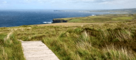
Strong gusts of wind coming from the Atlantic Ocean kept pushing us forward across the Fields. Apart from the remains of the prehistoric past scattered all over, we met a few clusters of sheep looking at us curiously, as if judging our rights of being present in their territory.

Behy Court Tomb in the middle of the Céide Fields. Copyright©Archaeotravel.

There are wooden walkways over the fields to make visitors feel more comfortable while walking and to avoid getting wet. No need to say, we deliberately gave up such facilities to reach real treasures of the site, walking directly through the bog, beyond the tourist track.

One of the most significant landmarks of the Fields was the megalithic monument, known as Behy Court Tomb. It is situated just in the middle of the Céide Fields, still partially buried in the bog peat. As explained by our professors, it was initially described as a passage tomb as it features an entrance passageway leading to the cruciform gallery inside it, which is an important characteristic of this group of Neolithic tombs (Earth is Mysterious 2019-2020).  Court tombs usually have neither an entrance passage or a cruciform gallery but an elongated rectangular burial chamber with the exedra or forecourt (Ibid.). As the latter element has been also found at Behy Tomb, it could be simply described as a hybrid variant of court and passage tombs. Still, it is usually defined as a court tomb in the professional literature on the subject.

Broken Fort

Before heading off back to Dublin, we were yet planning to visit the nearby site of Downpatrick Head, which is strongly associated with Saint Patrick and his mission of converting Ireland to Christianity.

The modern statue of Saint Patrick at the headland.
Copyright©Archaeotravel.

Saint Patrick is actually believed to have carried his ministry in the north of Ireland, particularly in County Mayo. As some local folklore stories go, one of the pre-Christian gods or pagan priests, Crom Cruach resided on the headland (modern Downpatrick Head) and kept holy fires burning continuously (Makem 1997). “He dominated the whole area and [people] feared him. […] Saint Patrick was travelling in the area and approached the point of the headland. Crom Cruach rose up against him. The saint picked up a rock, carved a cross on it, lifted it with both hands above his head and roaring out a prayer, hurled the rock with great force into the [holy] fire. There was a mighty explosion and a blinding flash. When the smoke and confusion cleared, the point of the headland had split off and was sitting out in the water with Crom Cruach still on it. He was destined to remain there until he died, which [was not] too long afterwards. According to the story, he suffered horribly, being eaten to death by midges” (Ibid.).

Very similar stories about the beginning of Christianity in Ireland, especially saying of the holy fire being extinguished by Saint Patrick, also circulate in County Meath. Similarly, they also refer to Saint Patrick’s fight with ancient priests and pagan gods on the Hill of Slane.

The beautiful legend told in County Mayo additionally offers an explanation for the origins of the sea stack of Dún Briste (Gaelic for Broken Fort) (Makem 1997). It is a single large rock at Downpatrick, protruding out of the ocean at the height of forty-five meters. Once joined to the mainland, now being lashed by foaming ocean, it is one of the most scenic landmarks of County Mayo and Wild Atlantic Way.

Spectacular cliffs at Downpatrick. Copyright©Archaeotravel.

“During the Second World War (or ‘the Emergency’, as it was known [there]), a lookout post was constructed [at Downpatrick] to keep watch for shipping or submarines that might stray into Ireland’s neutral waters and a large EIRE sign was created from white stones to warn aircraft away from crossing into Irish airspace” (Jackman 2018: site 70).

Private tour

Sitting over a cup of coffee inside the visitor centre at Céide Fields, I admitted to Professor Caulfield that I have been strongly interested in the studies on early Christianity in Ireland, once conducted by Françoise Henry (16 June 1902 – 10 February 1982), who was a scholar of early Irish art, archaeologist, and art historian at University College Dublin.

Doonfeeny standing stone with early
symbols of Christianity.
Copyright©Archaeotravel.

Henry was also a strong supporter of a thesis of Coptic influences on Pre-Romanesque art in Ireland. I knew Henry was studying early Christian symbols on prehistoric slab stones on the island of Inishkea North in County Mayo, where she kept returning between 1937 and 1950. Although the island was too far to get there, Professor Caulfield offered to guide me to another nearby site with cross-slabs, which was also on the way to our next scheduled destination. I enthusiastically agreed and drove to the site together with my guide, while the rest of the group was supposed to wait for us at Downpatrick.

Doonfeeny standing stone

Doonfeeny is a short five-minute drive from Céide Fields. We simply headed west on the road for a little over 2,5 kilometres and then turn right up a narrow road with grass growing in the middle of it (Jackman 2018: site 69). We followed this road for approximately 500 metres till we saw the tall stone pillar in the graveyard on one side and the ruins of a church on the other (Ibid.). We pulled in the car and started climbing up the hill to reach the slender trunk of stone soaring over the landscape.

Doonfeeny pillar in the graveyard. Source: Sacred Landscapes (2020).

“The area around Doonfeeny is an important early medieval landscape, with a number of ringforts and archaeological monuments” (Jackman 2018: site 69). Probably the most outstanding is our object of interest, the square-sectioned, leaning pillar “that stands proudly on a green hill overlooking the Atlantic” (Ibid.). The stone is also called a Menhir or Cloch Fada, which means ‘Long Stone’ (Sacred Landscapes 2020).

MENHIR, from the Breton words ‘men’ stone, and ‘hir’ is a long, a single upright stone, often of enormous size, which was deployed either on its own or in connection with a tomb site.

Megaliths. Encyclopedia of Stone Age Art (2020).

Although Doonfeeny stone is upright and fixed to the ground on its own, it does not look like a huge boulder as its shape is elongated and slender. “Folklore has it that this stone is on alignments with clefts in neighbouring hills and solar positions” (Ballycastle/Belderrig Development Co. 2020).

What was its original function?

“The Ordnance Survey letters (1838) describe the stone in the following manner: ‘A stone 18’ or 20’high and 9” thick, fixed in the ground and inkling to the East, on the N.W. side of which is cut the form of a cross about 2’ long, with a small cross 10” long and some ornamental incisions under it’” (Sacred Landscapes 2020).

Doonfeeny stone with the so-called Maltese cross, below the Latin cross. Copyright©Archaeotravel.

The Doonfeeny stone “was likely to have first been erected in the Bronze Age, perhaps to mark a territorial boundary, or possibly to mark the area as sacred” (Jackman 2018: site 69). The pillar is also called the Ogham stone as it boasts signs of ogham inscriptions. Ogham writing, apparently called after Ogmios, the Celtic God of writing, was the original “Irish alphabet used on monuments from 300 A.D. to 700 A.D.” (Ballycastle/Belderrig Development Co. 2020) (see Pictish Symbol Stones: from Pagan Beast to the Cross). Unfortunately, the ogham inscription incised on the stone are today mostly time-worn and cannot be deciphered (Ballycastle/Belderrig Development Co. 2020).

“There once existed a tradition in parts of the west of Ireland that some of these standing stones were used as ‘Fertility [Objects]’ by women seeking to get pregnant, or alternatively, as a primitive form of contraception, and it is recounted that women were known to prostrate themselves before these stones all the while praying that ‘they might be delivered from the perils of childbirth’” (Sacred Landscapes 2020). “Although we may never know for certain the true intention of those who erected the stone, it still undeniably creates a powerful visual signpost in the landscape. it stands some [five metres] tall, making it [the second highest standing stone] in Ireland” (Jackman 2018: site 69; see Ballycastle/Belderrig Development Co. 2020).

On the verge of Christianity

Doonfeeny cross with Latin cross (above) and Maltese or Greek cross (below).
Copyright©Archaeotravel.

As much as other prehistoric sites, Doonfeeny pillar “was appropriated in the early days of Christianity, and two crosses were carved into the stone, a single line Latin cross with forked ends and horizontal base placed over a double-line Maltese type cross with a curved ‘birds-head-design’ line [at its foot]” (Jackman 2018: site 69). Some interpret the symbol of ‘birds-head-design’ as the wheel and sun-burst that possibly would symbolise the Resurrection (Ballycastle/Belderrig Development Co. 2020). “The crosses may date to as early as the sixth century or seven century, or perhaps even earlier” (Jackman 2018: site 69).

Two forts and a killed swine

The site’s information boards says that the church ruins in Doonfeeny Churchyard date back to the seventh century (Sacred Landscapes 2020). Nevertheless, it was overbuilt on the site previously occupied by an ancient church, probably from the sixth century (Ibid.). The Ordnance Survey Letters (1838) and the board also inform that to the south of the church, there is a cemetery surrounded with a fosse in the form of a fort, which is Dún (Fort) giving its name to the parish: Dún Fhíne (Fine’s Fort) (Ibid.).

The layout of the Four Maols’ Fort. Source: Sacred Landscapes (2020).

After the information on the board, north of the parish church there is an earthen work, called ‘The Fairy Fort of Doonfeny’. In fact, these are the remains of Rath Ui Dubhda, standing for ‘O’ Dowd’s Fort (Sacred Landscapes 2020). As a local story goes, the Four Maols, known as the infamous murderers, built the original fort there, which they dedicated by killing a swine (Ibid.). This pagan act was apparently inspired by a pro-Christian tradition, where the animal was a substituted for human sacrifice (Ibid.). The board ads that the Four Maols’ grave can be seen in Ballina, a town in north County Mayo (Ibid.). The grave is well recognizable as it is marked by a dolmen (Ibid.).

Saint Patrick again

From the site  we could see Dún Briste at Downpatrick Head (Jackman 2018: site 69).

One of the so-called blow holes in the area of Belderrig. Copyright©Archaeotravel.

“It is enticing to consider that the ‘real’ Patrick may have seen this tall stone with his own eyes. It is not a great distance to Foghill, believed to be Foclut, the area that he described in his writings where he was held as a slave as a young man. The stone would have certainly already been standing for thousands of years before [St] Patrick’s time, and may have still been a distinctive marker on the landscape. If a young Patrick did see the stone, did he know what it symbolised? Or was it just another unknowable symbol in the strange pagan land in which he found himself?” (Jackman 2018: site 69).

Legend-encrusted blow-holes

When we finally caught up with the rest of the group reaching atop the visitor centre at Downpatrick, we were rewarded with “a wonderful view of this ancient and sacred landscape stretching as it does off down by the majestic Céide cliffs and across the foam to historic Downpatrick Head with its awesome, legend-encrusted blow-holes and the mighty storied sea-pillar of Dún Briste” (Sacred Landscapes, “Downpatrick Head” 2020).

Of the growling blow-holes we had already come across in the area of Belderrig, which are called Poille Beaga – ‘Small Holes’, the one on the headland of Downpatrick, Poll na Seantuinne or Poll na Sean Toinne, meaning ‘the Hole of the Old Wave’ (Sacred Landscapes, “Downpatrick Head” 2020) “is by far the largest, most impressive and the one most associated with the history and folklore of the place” (Ibid.). Although they are all carved naturally by thousands of years of marine erosion, there are a few legends ascribing these chasms more supernatural origins (Ibid.).

Legendary Ireland

Such stories are ubiquitous in whole Ireland. They may have appeared when ancient people were looking for a reason of natural phenomena. Nevertheless, in many cases, they may directly refer to historical circumstances or characters who had fired the imagination (Harpur, Westwood 1997:6).

Picturesque cliffs between Belderrig and Ballycastle. Copyright©Archaeotravel.

The seed of legend was definitely sown in this region of Ireland, whose ancient past continues to draw tourists, pilgrims and … archaeologists (Ibid.:6).

Featured image: Dun Briste at Downpatrick, Co. Mayo. Copyright©Archaeotravel.

By Joanna
Faculty of History of Art and Archaeology
Cardinal Stefan Wyszyński University in Warsaw, Poland
University College Dublin, Ireland

BIBLIOGRAPHY:

“Belderrig” (2019). In Wikipedia. The Free Encyclopedia. Available at <https://bit.ly/361bvic>. [Accessed on 15th May, 2020].

“Céide Fields” (2020). Wikipedia. The Free Encyclopedia. Available at <https://bit.ly/366l6o6>. [Accessed on 16th May, 2020].

“Megaliths” (2019) In: Toppr. Available at <https://bit.ly/2X5Gg1C>. [Accessed on 17th May, 2020].

“Menhir” (2020) In: Megaliths. Encyclopedia of Stone Age Art. Available at <https://bit.ly/2WFCLQv>. [Accessed on 17th May, 2020].

Ballycastle/Belderrig Development Co. (2020) “Standing Stone”. In: Welcome to Ballycastle Co. Mayo. Available at <https://bit.ly/2T6eSiP>. [Accessed on 16th May, 2020].

Byrne M. (2020) “Irish Wedge Tombs”. In: The Sacred Island. Available at <https://bit.ly/2WCd7vS>. [Accessed on 16th May, 2020].

Earth is Mysterious (2019-2020) “Megaliths: Stone Age Architecture”. In: Earth is mysterious. Available at <https://bit.ly/3bEOB1t>. [Accessed on 17th May, 2020].

Fagan B. M., Durrani N. (2016) Archaeology: A Brief Introduction. London & New York: Routledge.

Flanagan L. (1999) Ancient Ireland: Life before the Celts. London: Palgrave Macmillan.

Harpur, J. Westwood, J. (1997) The Atlas of Legendary Places. New York: Marshal Editions.

Jackman N. (2018) Ireland’s Wild Atlantic Way: A Guide to its Historic Treasures. Cork: The Collins Press.

Kelly C. (2016) “Rural Heritage and Tourism in Ireland: A County Mayo Case Study”. In: Heritage and Tourism in Britain and Ireland. Hooper G. ed., pp. 113-126. Glasgow: Palgrave McMillan.

Lavin P. (2011) The Shaping of the Celtic World: And the Resurgence of the Celtic World. Bloomington: Universe Inc.

Lucie-Smith, E. (2003) The Thames & Hudson Dictionary of Art Terms. London: Thames & Hudson World of Art.

Makem T. (1997) “Céide Fields”. In: Tommy Makem’s Secret Ireland. Thomas Dunne Books.

Mayo Ireland Ltd. (2020) “Belderrig in Co. Mayo”. In: Mayo Ireland. Available at <https://bit.ly/3byWbdV>. [Accessed on 15th May, 2020].

McNulty A. (2008) “Back in Time in Belderrig”. In: Mayo News. Available at <https://bit.ly/361bvic>. [Accessed on 15th May, 2020].

Sacred Landscapes (2020) “Doonfeeny Standing Stone & Church”. In: Sacred Landscapes. Available at <https://bit.ly/2T8ORPF>. [Accessed on 16th May, 2020].

Sacred Landscapes (2020) “Downpatrick Head”. In: Sacred Landscapes. Available at <https://bit.ly/2Z9of4V>. [Accessed on 16th May, 2020].

The Oldest Temple in the World and its Mystery

An ancient temple dated back to 10 000 BC. has been discovered in the Middle East (Conrad 2012). It was built when mankind was still in the Stone Age and before people discovered the so-called first signs of Neolithic human society: the pottery, writing, and the wheel (Ibid.). Consequently, its construction goes back long before the earliest great civilizations, like the Mesopotamians, the Egyptians, and the Minoans. Then who built it and why? (Ibid.).

Building archaeological recording underway in the southeast hollow (main excavation area) at Göbeklitepe (September 2018). The new permanent shelter provides visitors not only with unprecedented views of the excavated monumental buildings but also allows them to get close to the archaeologists working at the site. The membrane canopy was designed by kleyer.koblitz.letzel.freivogel Architekten (with structural engineering by EiSat GmbH), btw. (see Donna Sink (2020). In: Archinect News). Photo and caption source: German Archaeological Institute (DAI). In: Jens Notroff (2018) “Visitors back at the ruins again”. In: German Archaeological Institute (DAI) (2020). The Tepe Telegrams. News & Notes from the Göbekli Tepe Research Staff.

This is the story of Göbekli Tepe and its bewildering imagery.

From evolution to revolution

As it has been always taught, human species had evolved very slowly (Conrad 2012). For millennia, people had managed to survive by hunting and gathering their food till around 10 000 BC., when something extraordinary happened: their development strangely speeded up and in a comparatively short period of time people achieved the highlands of their development (Ibid.).

The location of Göbekli Tepe on the map, near the large nearby modern city of Şanlıurfa. Source : documentary shot from Kevin Burns (2017) “Return to Gobekli Tepe”. In: Ancient Aliens, Season 12, Episode 16. Prometheus Entertainment.

What was it that made humankind change so drastically? (Conrad 2012). After scholars, the turning point in human history was the Neolithic Revolution, namely having learnt how to farm and produce food instead of gathering or hunting (Ibid.). The theory is that farming allowed people to settle down, then develop religious systems and finally build temples to gods (Ibid.). Subsequently, simple settlements grew to cities and then into powerful civilisations, which developed around 3 000 BC (Ibid.). Without having to hunt or gather for every meal, people  had more time to evolve out of the Stone Age (Ibid.). According to the traditional thinking, such complex structures as Göbekli Tepe could hence be only planned and built by already well-established agricultural communities, according to the following scheme: the Neolithic farming and settlement encouraged religious practices, which in turn led to temples building and a successive development of cities (Ibid.). So much about the theory …

From the theory to archaeological evidence

With the appearance of Göbekli Tepe, the traditional thinking has been turned on its head (Conrad 2012). An American archaeologist, Dr Jeffrey I. Rose, an expert on early human history and stone age technology, admits that “what has been found in [the southern-east Anatolia is] incredible as it puts a whole new spin on human cultural evolution” (Ibid.). As shown by archaeological finds, the builders of the site were not farmers at all but they were still hunter-gatherers (Ibid.). This is why the site is so controversial, and for this reason it upends the conventional view of the growth of civilisation (Ibid.).

Hunter-gatherers. Photo cropped. Source: Archaeology Newsroom (2020) .In: Archaeology & Art.

According to well-established stereotypes, hunter-gatherers are usually seen as a kind of mumbling primitives. Slavishly devoted to their survival and basic instincts, devoid of higher skills, feelings or religion, these people were able to produce artistic, architectural and sacral masterpiece unknown in the academic world before the discovery of Göbekli Tepe. Dr Rose (Conrad 2012) admits his own surprise, saying: “It’s like discovering that a three-year-old child built the Empire State Building out of toy bricks” (Ibid.). The same opinion is shared by Hassan Karabulut, associate curator of the Urfa Museum: “They had barely emerged from the most basic way of life” (Scham 2008:23) he says,’ amazed that nomadic peoples were able to organize such a large labour force (Ibid.:23).  

Never-ending studies

The site was first mentioned in 1963, in a survey carried out by Istanbul University and the University of Chicago (Benedict 1980). American archaeologist, Peter Benedict identified lithics collected from the surface of the site as belonging to the Aceramic Neolithic (Schmidt 2011:917) but misidentified the upper parts of the ‘T’-shaped pillars for grave markers, postulating that the prehistoric phase was overlain by a Byzantine cemetery (Batuman 2011; Andrews 2016).

The upper part of the ‘T’ – shaped pillar protruding out of the ground. Source : documentary shot from Kevin Burns (2017) “Return to Gobekli Tepe”. In: Ancient Aliens, Season 12, Episode 16. Prometheus Entertainment.

“The hill had long been under agricultural cultivation, and generations of local inhabitants had frequently moved rocks and placed them in clearance piles, which may have disturbed the upper layers of the site” (“Göbekli Tepe” 2020). With time, attempts had been made to cut up some of the pillars, likely by farmers who thought they were ordinary large boulders (Curry 2008; see “Göbekli Tepe” 2020).

Sites with similar ‘T’-shaped pillars from the Pre-Pottery Neolithic (PPN). Photo by Arekrishna (2017). CC BY-SA 4.0. Source: “Göbekli Tepe” (2020). In: Wikipedia. The Free Encyclopedia.

Although archaeological research at Göbekli Tepe has been carried out since the early 1960s, only in 1994 the site emerged as the world’s first temple with an amazing discovery of  mysterious statues (Conrad 2012).

In 1994, on a nearby hill, a Kurdish shepherd had noticed a strange outline of a stone sticking out of the ground (Burns 2010). He turned out to be more interested in the find than his countrymen who discerned the protruding boulders before him, and began digging around the stone (Ibid.). Soon he discovered below a six-meter shaft (Ibid.). It had a regular structure and there was a relief showing an unknown animal (Ibid.) (see:). Thorough examinations confirmed that the stone was processed by a talented stonemason who used sophisticated tools (Ibid.). When the scholars found out about the accidental discovery, they were sure that the Shepherd had discovered one of the most important structures in the history of archaeology (Ibid.). In the same year, regular excavations began.

The team of archaeologists led by Professor Klaus Schmidt of the German Archaeological Institute started their regular work at Göbekli Tepe in 1995, in collaboration with the Şanlıurfa Museum, and soon unearthed the first of the huge ‘T’-shaped pillars (Curry 2008; Noren 2020; see “Göbekli Tepe” 2020). Schmidt writes that “as soon as [he] got there and saw the stones, [he] knew that if [he] didn’t walk away immediately [he] would be [tere] for the rest of [his] life” (Knox 2009), which eventually happened. Having found stone structures at Göbekli Tepe similar to those unearthed before at Nevalı Çori (Turkey), Schmidt recognized the possibility that the monuments are prehistoric and culturally related to other archaeological sites in the region (“Göbekli Tepe” 2020; see Noren 2020).

Photo (2016) of Klaus Schmidt (11 December 1953 – 20 July 2014); a German archaeologist who led the regular excavations at Göbekli Tepe from 1995 to 2014. Photo source: Oliver Dietrich (2016) “Göbekli Tepe – The first 20 Years of Research”. In: German Archaeological Institute (DAI) (2020). The Tepe Telegrams. News & Notes from the Göbekli Tepe Research Staff.

Since then, there have been multitude of various studies carried out at the archaeological site of Göbekli Tepe, which became extremely famous for its unique megalithic constructions. As such, it has attracted an international attention of scholars and researchers keen to discover its well-hidden secrets, especially by means of research on the iconography of the Neolithic in the Southeastern Anatolia. Yet before Göbekli Tepe was uncovered, scholars from around the world had become very attracted to the Neolithic period of the region, especially with broad excavations started at the site of Çatalhöyük in 1960s.

Hill of the Navel

The site of Göbekli Tepe is situated on top of a hill that is the highest point of the Urfa Plain in Turkey, with the Taurus Mountains to the north and east, and the Harrain Plain to the south. Turkey itself is an ancient land that bridges Europe and Asia (Conrad 2012). It is also a part of the Fertile Crescent – a swathe of the Middle East and Africa that includes modern Egypt, Israel, Syria and Iraq (Ibid.). In this green belt humans are believed to have first settled and the world’s earliest civilizations to have arisen around 3 000 BC.

Area of the Fertile Crescent, circa 7500 BCE, with main sites. Göbekli Tepe is one of the important sites of the Pre-Pottery Neolithic period. The area of Mesopotamia proper at this time was not yet settled by humans. Photo by GFDL (2019). CC BY-SA 3.0. Source: “Göbekli Tepe” (2020). Wikipedia. The Free Encyclopedia.

In Turkish, the name Göbekli Tepe means ‘hill of the navel’ and to the anthropologists, such as Sandra Scham (2008:27), this is “the metaphor of a human birth to describe the creation of the world.” After her interpretation, the name of the site seems significant itself as by its name it refers to such sacred ‘navels’ as Cusco in Peru, Easter Island and Delphi in Greece (Ibid.:27). Local people believe the hill to be sacred as well (Conrad 2012).

Four stone circles

Ground penetrating radar has allowed to estimate the size of Göbekli Tepe to 300 by 300 metres (Conrad 2012). Professor Schmid and his team have so far excavated four huge stone circles, labelled as A, B, C, and D (Conrad 2012; Busacca 2017). They measure roughly from 10 to 30 metres in diameter (Ibid.). Each one is surrounded by a high stone wall, broken by intervals by large ‘T’-shaped pillars (Ibid.). In the middle of each, there are two massive monoliths up to five and a half metres tall (Ibid.). These enclosures are not analogous to any other existing archaeological structures in the world (Ibid.).

Göbekli Tepe. The main excavation area in the southeastern area of the mound in an aerial photograph by Erhan Kucuk and a schematic map with pillar numbering. Courtesy of the German Archaeological Institute, DAI. Source: Gesualdo Busacca (2017:317). “Places of Encounter: Relational Ontologies, Animal Depiction and Ritual Performance at Göbekli Tepe”. In: Cambridge Archaeological Journal, v. 27, issue 2, pp. 313-330.

Professor Schmid knew that the site has covered many more enclosures than just the unearthed four (Conrad 2012). The map generated from the ground penetrating radar survey reveals that there are at least other sixteen circular structures still buried beneath the hill, and some of them are situated much deeper than the uncovered four (Ibid.). These are hence the oldest enclosures of all, dated back to as far as 13 000 BC, which is the end of the last Ice Age (Ibid.).

Although only a small part of  Göbekli Tepe has been unearthed, it can be concluded that it was built in two successive stages (Busacca 2017:316). The first structures excavated there were erected as early as 10 000 B.C., that is to say in the early Pre-Pottery Neolithic A (Ibid.:316). Whereas the later remains are dated back to the later Pre-Pottery Neolithic B, and strangely they are much less sophisticated than the earliest structures which contain most of ‘T’ shaped pillars covered in zoomorphic sculpture (Ibid.:316). The earliest enclosures were built on the bedrock into slots only about ten centimetres deep (Conrad 2012). The builders set two central monoliths up to five and a half metres tall and carved from a single piece of stone, weighing up to fourteen and a half of tons (Ibid.).

Enclosure D of Göbekli Tepe. Photo by Nico Becker, DAI. Photo source: German Archaeological Institute (DAI) (2020). “The Site” In: The Tepe Telegrams. News & Notes from the Göbekli Tepe Research Staff.

Around the two monoliths, the masons then built a wall of stones and mortar, nearly two metres tall (Ibid.). Set into the wall, there are smaller ‘T’ – shaped pillars between three and five metres high and weighing up to ten tons (Ibid.). Now disintegrated, there is the portal stone and apparently it was an entrance to the enclosure (Ibid.). Once incorporated vertically into the wall, it was carved from a single piece of stone, like pillars, and weighs several tons (Ibid.). Carving these huge sown blocks would have required considerable skills and some knowledge of geology as well (Ibid.).

More advanced technically than later constructions …?

Göbekli Tepe is a much more elaborated structure than Stonehenge, even if it apparently predates the British megaliths by about 6 500 years (Scham 2008:23; Conrad 2012). To build a place like this, Stone Age people would have required a pretty sophisticated level of organization, especially a well-coordinated workforce of stonemasons, diggers, quarry-men, and hundreds of people to drag the stones up and set them in place (Conrad 2012). Together with his colleagues, Klaus Schmidt estimates “that at least 500 people were required to hew the ten to fifty ton stone pillars from local queries, move then from as far as a quarter-mile [over four hundred metres] away, and erect them” (Scham 2008:26). Moreover, according to the theory of the Neolithic Revolution, people had not yet domesticated packed animals at that time to make them assist and so speed up the construction of the stone circles (Conrad 2012). So how did they manage to build something so monumental before they even discovered how to make a clay pot? (Ibid.).

Göbekli Tepe. Main excavation area with monumental Pre-Pottery Neolithic (PPN) A enclosures. Photo by Nico Becker, DAI. Photo and caption source: German Archaeological Institute (DAI) (2020). “The Site” In: The Tepe Telegrams. News & Notes from the Göbekli Tepe Research Staff.

In the quarry from where the stone was acquired, there is apparently one unfinished monolith of seven metres long (Conrad 2012). It is believed that by using granite picks, the Stone Age masons roughly carved it out as it is still in the bedrock (Ibid.). To remove it, they were likely to use primitive levers and a fulcrum (the point against which a lever is placed, on which it turns or is supported) They may have positioned the fulcrum at the front, and then the levers went over it. By these means, the masons were prying the boulder up (Ibid.). A crack on the stone, which is visible today, would suggest the monolith was broken while being lifted up (Ibid.). Having separated the blocks of stone from the bedrock, the builders may have transported them up to the hill by the method described as “rowing on land”; one can imagine people, instead of sitting inside the boat, standing outside it, and pushing down on the leaver and then pulling back on it and so the boulder would be moved forward (Ibid.). Around fifty people would be possibly needed to complete the task (Ibid.). Has this method been ever tried out with a real fourteen-ton (or heavier) block of stone? Is the number of fifty men able to crowd at once around the boulder, which is 15 metres long?

What was the site used for?

The site does not have its counterpart elsewhere, which makes it the oldest man-made construction yet discovered in the world (Conrad 2012). As such it constitutes highly significant monument to be studied (Ibid.). Schmid claims that “the site could not definitely have served for a daily life” (Ibid.). He has worked on other prehistoric sites in Turkey and he says that the structures of Göbekli Tepe do not resemble any kind of clustered dwellings that Stone Age people built (Ibid.). The temple sits on the hill with no direct access to water so people had to carry their food and drink up there, which means they could not stay at the site very long (Ibid.). They had to live elsewhere, possibly on the place of the modern city of Şanlıurfa (ancient Edessa), around fifteen kilometres away (Ibid.).

Göbekli Tepe site during excaviations. Photo by Klaus-Peter Simon (2012). CC BY-SA 3.0. Source: “Göbekli Tepe” (2020). In: Wikipedia. The Free Encyclopedia.

Most archaeologists believe that if the monumental sculpted pillars of Göbekli Tepe show the representations of gods, it is likely to consider the site as some kind of a sanctuary (Ibid.). If so, it would have been the oldest temple in the world (Conrad 2012).

Shrinking temple

Despite various studies, Göbekli Tepe’s function and the meaning behind its imagery still remain unknown (Conrad 2012). The mystery deepens by the fact that after the huge effort to build this extraordinary structure, the people who used it, then subsequently buried it (Ibid.).

The downfall of the oldest temple in the world is as mysterious as the religion it once served (Conrad 2012). For over a thousand years, the temple had occupied the central place in the cultural life of the region (Ibid.). People from hundreds kilometres away may have gathered there and used it as a ritual space (Ibid.). However, as the importance of agriculture grew in time, the temple’s role must have diminished (Ibid.). Thousands years after the large circular spaces with the massive monoliths were built, they were filled in and covered over (Ibid.). Instead, smaller structures were built on top of it (Ibid.). Consequently, it looks like Göbekli Tepe was being downsized: the enclosures had got smaller, the pillars progressively shorter and their number in the surrounding wall had dwindled until there were none (Ibid.). Finally, Göbekli Tepe disappeared in around 8 000 BC, buried beneath man-made hill (Ibid.).

Following the star

Each built circle of stones had been used for several hundred years and then filled in to be replaced by another one (Burns 2017). In total, the builders of Göbekli Tepe constructed twenty such circles – temples, which were different in size (Ibid.). Schmid claims that “it was a part of the program to erect such a circle to use it for some time but later to backfill it completely” (Conrad 2012). Hence the modern appearance of the site, which looks like a mount (Ibid.). It was because eventually all these mounds with covered temples became one big hill (Ibid.).

Cygnus constellation with the brightest star Deneb. Photo by Star Walk (2017).“A Gorgeous Quarter Moon meets Saturn, and the Swan’s Wings bear its Best Features!”. In: Medium.

An author, Andrew Collins, proposes an alternative, yet controversial, theory, according to which the builders constructed the successive temples for astronomical purposes (Burns 2017). Namely, the reason of the multiple rebuilding of the site would be to follow a particular celestial body (Ibid.).

Göbekli Tepe. Photo by Zhengan (2012). CC BY-SA 4.0. Source: “Göbekli Tepe” (2020). In: Wikipedia. The Free Encyclopedia.

Archaeoastronomy survey has shown that 11 500 years ago, the twin central pillars of the most impressive of so far unearthed circles, the Enclosure D, faced the Denab in the sky, which is the brightest star in the constellation of Cygnus (Burns 2017). When the alignments of other twin pillars of Göbekli Tepe were studied in reference to the same star, it turned out that the Stone Age builders apparently kept following the Denab by building successive enclosures as the star slowly moved along the local horizon (Ibid.). Hence the twin pillars within successive enclosures were deliberately aligned according to the star that the people of Göbekli Tepe were observing (Ibid.). As in the process of Precession, the position of stars change overtime in the sky, the builders also had to re-align their temple periodically, each several hundred years (Ibid.).

The downfall of the temple

Some scholars, including archaeologists and geologists, put forward a controversial thesis explaining why Göbekli Tepe eventually ceased to exist. Namely, the Stone Age site is believed to have been destroyed by the Great Flood, recorded not only by the Bible but also dozens of other ancient sources coming from different corners of the world (Burns 2014-2015). Robert Schoch, PhD. (Burns 2014-2015) believes that there is enough evidence supporting the thesis that a great disaster had taken place at the end of the period that marked the end of the Ice Age; as a result, the great pillars of Göbekli Tepe were overthrown and the damage to the temple must have been large and extensive. Attempts surely were made to rebuild it, but people eventually gave up and buried the whole place (Ibid.). Perhaps they wanted to return there one day or leave it for posterity (Ibid.). Or else the temple was naturally covered with earth yet during the Flood, the waters of which had carried huge amounts of soil and organic materials into and over the temple complex.

After Dr. Rose, the reason why the site ultimately disappeared may be possibly explained by the appearance of a sanctuary within the now flooded archaeological site of Nevalı Çori, which was situated around thirty kilometres away from Göbekli Tepe (Conrad 2012). It was a Stone-Age village with a small temple from around 8 000 BC. (Ibid.). A small square enclosure had similar architectural elements as Göbekli Tepe: thirteen stone pillars in its walls and two faceless monoliths in its centre, with arms and hands carved on (Ibid.). In this context, it is a smaller and localized version of the Stone Age cathedral at Göbekli Tepe, looking more like a village church (Ibid.). Dr. Rose says that sacred spaces showing up at that time coincided with the downfall of the Göbekli Tepe so local communities had started to build their own sacred spaces, when the central temple stared losing its importance (Ibid.).

Restoration of a typical interior of Catal Höyük dwelling. The Museum of Anatolian Civilizations, Ankara, Turkey. Copyright©Archaeotravel.

Another explanation of the abandonment of the site is that the descendants of Göbekli Tepe builders were no longer hunter-gatherers (Conrad 2012). They were farmers and they did not follow the religion of their ancestors per se but rather the ideas it represented (Ibid.). Their traces can be found at the archaeological site of Çatalhöyük (Turkey) – which is said to be one of the oldest cities, developed between 8 000 and 7 000 BC. (Ibid.). In a restored house of Çatalhöyük, there are the bull heads sticking out of the wall as much as zoomorphic representations carved on the pillars of Göbekli Tepe (Ibid.). Bulls must have meant large, scary and killing beasts for the society of Çatalhöyük (Ibid.). Bringing that animal power and violence inside the house was probably an attempt to tam it and to domesticate (Ibid.). It could be also a celebration of the animal’s strength or the hunt and prowess of the individuals (Ibid.). On the other side, the respect the Stone Age people had for wild and powerful beasts also hid their desire to conquer them (Ibid.). Accordingly, it seems that spiritual and physical story of Göbekli Tepe was spread far and wide (Ibid.).

Whatever the meaning of its symbolism was, the visible links to its imagery can be found at later sites throughout the region (Ibid.), which signifies it was truly important.

Many myths and legends claim that sophisticated cultures already existed at the very beginning of human civilization (Burns 2010). Robert Schoch, PhD. claims that there are various signs from all over the world that advanced societies had developed much earlier than previously thought (Ibid.). The discovery of Göbekli Tepe is hence completely contradictory to the current view of the slow evolution of civilization (Ibid.). Interestingly, since the archaeological digs started on site, neither a single tool for stone processing nor human remains have been found (Burns 2010; 2017). The former lack contradicts the sophisticated carving created on site, whereas the latter excludes Professor Schmid’s theory of Göbekli Tepe as a burial complex (Burns 2017). It was not either a domestic settlement (Ibid.). An archaeologist, Paul Bahn, PhD., claims that when something in archaeology is incomprehensible, given finds are usually assigned ritual significance but these are pure speculations (Ibid.). Taking into account such facts, will the discovery of Göbekli Tepe radically change the world view of the beginning of human civilization? (Ibid.) Is the find of Göbekli Tepe the missing evidence that mankind’s strangest myths about lost civilizations can be based on facts? (Ibid.)

Featured image: “Göbekli Tepe, Şanlıurfa”. Photo by Teomancimit (2011). CC BY-SA 3.0. (Image cropped). Source: “Göbekli Tepe” (2020). Wikipedia. The Free Encyclopedia.

By Joanna
Faculties of English Philology, History of Art and Archaeology.
University of Silesia in Katowice, Poland;
Cardinal Stefan Wyszyński University in Warsaw, Poland;
University College Dublin, Ireland.

BIBLIOGRAPHY:

“Göbekli Tepe” (2020). In: Wikipedia. The Free Encyclopedia. Available at <https://bit.ly/2Loo1id>. [Accessed on 11th May, 2020].

Andrews E. (2016). “World’s Oldest Monument to Receive a Multi-Million Dollar Investment”. In: HISTORY.com. Available at <https://bit.ly/3bn8xWD>. [Accessed on 11th May, 2020].

Batuman E. (2011). “Turkey’s Ancient Sanctuary.” In: The New Yorker. Available at <https://bit.ly/3dCx9vI>. [Accessed on 11th May, 2020].

Benedict P. (1980). “Survey Work in Southeastern Anatolia”. In: Çambel H, Braidwood, R. J.  ed. Prehistoric Research in Southeastern Anatolia I. Edebiyat Fakültesi Basimevi, Istanbul, pp. 151–191.

Burns K. (2017). “Return to Gobekli Tepe”. In: Ancient Aliens, Season 12, Episode 16. Prometheus Entertainment.

Burns K. (2014-2015). “The Great Flood”. In: Ancient Aliens, Season 9, Episode 8. Prometheus Entertainment.

Burns K. (2010). “Unexplained Structures”. In: Ancient Aliens, Season 2, Episode 8. Prometheus Entertainment.

Busacca G. (2017). “Places of Encounter: Relational Ontologies, Animal Depiction and Ritual Performance at Göbekli Tepe”. In: Cambridge Archaeological Journal, v. 27, issue 2, pp. 313-330.

Conrad T. (2012) Cradle of the Gods. Atlantic Productions LTD. for National Geographic Channels. Available at <https://bit.ly/3blMwas>. [Accessed on 11th May, 2020].

Curry A. (2008). “Göbekli Tepe: The World’s First Temple?”. In: Smithsonian Institution. Available at <https://bit.ly/3dAM21E>. [Accessed on 11th May, 2020].

Dietrich O. (2016) “Göbekli Tepe – The first 20 Years of Research”. In: German Archaeological Institute (DAI) (2020) The Tepe Telegrams. News & Notes from the Göbekli Tepe Research Staff. Available at <https://bit.ly/2WKxRAr>. [Accessed on 11th May, 2020].

Documentary shots: Burns K. (2017) “Return to Gobekli Tepe”. In: Ancient Aliens, Season 12, Episode 16. Prometheus Entertainment.

German Archaeological Institute (DAI) (2020). “The Site” In: The Tepe Telegrams. News & Notes from the Göbekli Tepe Research Staff. Available at <https://bit.ly/2SZBily>. [Accessed on 13th May, 2020].

Knox T. (2009). “Do these mysterious stones mark the site of the Garden of Eden?”. In: Mail Online. Available at <http://dailym.ai/2xXjLmR>. [Accessed on 12th May, 2020].

Notroff J. (2018). “Visitors back at the ruins again”. In: German Archaeological Institute (DAI) (2020). The Tepe Telegrams. News & Notes from the Göbekli Tepe Research Staff. Available at <https://bit.ly/3miNaem>. [Accessed on 13th May, 2020].

Photo: “Hunter-gatherers” by Archaeology Newsroom (2020).  In: Archaeology & Art. Available at <https://bit.ly/3cs4qda>. [Accessed on 13th May, 2020].

Photo “Cygnus constellation” by Star Walk (2017) “A Gorgeous Quarter Moon meets Saturn, and the Swan’s Wings bear its Best Features!”. In: Medium. Available at <https://bit.ly/2WuI7h7>. [Accessed on 14th May, 2020].

Sink D. (2020). Comment on the article. In: Walter A. (2020). “Predating all known ancient civilizations, Göbekli Tepe may be world’s first architecture”. In: Archinect News. Available at <https://bit.ly/2Wb4ZSc>. [Accessed on 13th December, 2020].

Scham S. (2008). The World’s First Temple. Archaeology, v. 61, no. 6, New York: Archaeological Institute of America, pp. 22-27.

Schmidt, K. (2011) “Göbekli Tepe: A Neolithic Site in Southwestern Anatolia”. In: Steadman S. R., McMahon G. eds. The Oxford Handbook of Ancient Anatolia. Oxford: Oxford University Press.

‘The Way of Rama’ Between India and Sri Lanka

In May 2012, a NASA satellite passed over shallow waters of the Indian Ocean (Woolford-Gibbon, Durkin 2017). It sent back images of a chain of largely submerged objects running between Sri Lanka and India (Ibid.). The NASA image analyst, Marc D’Antonio, describes it as “a string of pearls between two islands” (Ibid.). Similarly, the archaeologist, Chelsea Rose compares it to “a rocky jetty but pretty bigger” (Ibid.). On closer analysis of the satellite image investigators calculate the line of rocks is over thirty kilometres long (Ibid.). What makes the image especially intriguing is that the displayed rocks are located in the area of sea, mentioned in an ancient Indian Sanskrit epic, which also refers to a mythical bridge (Ibid.).

The location of Adam’s Bridge between India and Sri Lanka on Google’s Map. Photo source: Dr. Rita Louise (2013). “Rama’s Bridge: Where Modern Science And Ancient Myths Collide”. In: Ancient Origins.

The Way of Rama

The Indian Sanskrit epic is known as Ramayana. It literally means the ‘Way of Rama’ and constitutes one of the great epics of India, of which the other is known as Mahabharata (Van Nooted 2000:xiii). Both epics had originated from folk tales and belong to the so-called Smriti scriptures (The Editors of Encyclopaedia Britannica 2020). Such writings encompass Hindu stories originally passed down by oral tradition (Ibid.). Ramayana is generally believed to have been written by the sage-poet Valmiki, between the fifth century BC and first century AD (Basu 2016).

According to the Sanskrit, Valmiki tells the story of Ramayana to Rama’s sons, the twins Lava and Kush (Ibid.). Nevertheless, the Ramayana date is not certain as much as the authorship of the epic (Van Nooted 2000:xv). The poet, Valmiki, himself is a half-legendary character (Ibid.:xv). Therefore, although Ramayana is very important of the Hindu tradition, it is usually said to have nothing to do with an exact historical chronology (Ibid.). As it speaks of the events recorded orally for centuries, the story itself may be much older that the written version (Ibid.:xv). However, to make their assumptions safe, scholars usually say “that Valmiki (if he really was the composer) drew upon a number of popular Rama folk tales for his epic, which he wove together into a great frame story, together with numerous exotic and fabulous incidents” (Ibid.:xv).

Valmiki training Lava Kusha (sons of Rama & Sita) in the art of archery. Author: Tej Kumar Book Depo. Public domain. Photo source: Wikimedia Commons (2018).

Chronological discrepancies

As a matter of fact, there are a few alternative chronologies concerning the events described by Ramayana, as much as it occurs in other archaeological areas, such as the Egyptology, where there is a difference of around one hundred years between the so called ‘high’ (the older) and ‘low’ (the younger) chronologies of the ancient Egypt. In case of the time frames for Ramayana, however, such a gap is incomparably larger.

According to the Hindu tradition, the events described by Ramayana took place during the Treta Yuga, which is the second of the four Yugas and the so-called Silver Age (Jagadisa Ayyar 1996:3). All of the periods are cosmic cycles as the starting point of each of them was formed by the conjunction of planets (Ibid.:3). Additionally, each successive age is shorter than the previous one (Ibid.:3). Some Hindu sources say that the Treta Yuga had lasted for 1 296 000 years (Ibid.:3). When did it start? According to such calculations, it was a period of time that began from over two millions years BC and ended around eight hundred thousand BC (!!!) (Jagadisa Ayyar 1996:3; Louise 2013), which sounds absurd (Louise 2013). This is probably why some scholars have re-calculated the time to make it “more” plausible. After their assumptions, the same epoch started in 5 500 BC and ended in 4 250 BC (Mittal 2006:xxiv). Such a time frame would be possible providing that twenty years is an average reign of each of sixty-three kings who were historically recorded (Ibid.:xxiv). Whereas according to the Hindu tradition, the average age of man in the Treta Yuga was three hundred years (Jagadisa Ayyar 1996:3), which is actually similar to the age ascribed to great biblical patriarchs in Genesis.

Statue of Rama in Kangra district of Himachal Pradesh, India (published in 2012). Photo by Ashish3724 (2012). CC BY-SA 3.0. Source: Wikipedia Commons (2020).

There have also been other surveys carried out in order to prove the historicity of Ramayana. By using modern scientific tools, such as archaeoastronomy, some Hindu researches have studied if any exact dates in the western calendar can be attributed to Rama’s lifetime (Hari, Hema Hari 2015). Ramayana, as much as Mahabharata, are regarded as traditional historical and religious texts of India and as such they are believed to contain real astronomical information also supported by observations recorded by the Hindu chronicles (Ibid.). Subsequently, the researches applied the ancient knowledge of configurations of celestial bodies to calculate the time when Rama’s birth may have happened (Ibid.). As a result, they have obtained the precise date of 10th January, 5 114 BC and then, using the same key, they have received further dates of successive events appearing in Ramayana, among which the construction of Ram Setu falls between the 14th and 20th September, 5076 BC (Ibid.). Accordingly, the research results are closer to the so called ‘low’ chronology of Treta Yunga, and consequently of Ramayana, if we can apply such a definition also to the ancient times of India and Sri Lanka.

Is the story a historical record or a myth?

The theory that the events of Ramayana should be dated back to thousands or even millions years ago is considered highly unscientific to western researches. But while it is not acceptable for real historical events, after the same scholars, it fits well in the sphere of myths, which is believed to have been actually presented in the epic. For many mainstream historians who have analysed the text, such a theory is supported by the fact that Ramayana tells a story filled with fairy like characters and describes unrealistic events typical of fiction: divine beings fly on aircrafts between masses of lands, giants, hybrids and demons walk the earth, ape-men construct an engineering feat, and all that is observed by powerful gods who decide about the course of earthly events. In this case, however, what means fiction for western scholars is a religious truth for the Hindus.

Ravana’s sister Suparnakha attempts to seduce Rama. He refuses and spurns her.
Internet Archive Book Images (2015) Image from page 534 of “Indian myth and legend” by Mackencie, D. (1913). Public domain. Uploaded in 2015. Photo source: “Rama” (2020) Wikipedia. The Free Encyclopedia.

Rama of Ayodhya is the protagonist of the story (Van Nooted 2000:xiii). He is born as a prince but he is forced to abdicate his claim to the throne in favour of his half-brother (Ibid.:xiii). As a result, “Rama himself withdraws into the forest for thirteen years accompanied by his faithful wife Sita and a his devoted half-brother, Lakshmana” (Ibid.:xiii-xiv).

The action of the story is rising when they all get into conflict with “the legions of the dark, the Rakshasas or demons” (Ibid.:xiv). The struggle culminates when two brothers, Rama and Lakshmana, humiliate Shurpanakha who is the demon king’s sister. As a result, her powerful brother, ten-headed Ravana takes revenge for his sister’s disgrace by abducting Sita (Ibid.:xiv). The demon takes Rama’s wife on board of his aircraft, vimana, and they fly together to Ravana’s kingdom on the island Lanka, today associated with Sri Lanka” (Ibid.:xiv). The demon’s capital, in turn, is usually localized at the famous Rock of Sigiriya, which is rising just in the middle of the island (see In the Realm of Demon Ravana).

Movie Still From The Film Raavan (2010), directed by Mani Ratnam; starring: Abhishek Bachchan, Aishwarya Rai. In the photo:  Abhishek Bachchan. Photo Source: “Raavan” (2016). In: Bollywood Hungama. Bollywood Entertainment at its Best.

In search for Sita, Rama and Lakshmana ally with the Vanara – an army of ape men and bears under the generalship of the mighty ape-man Hanuman (Van Nooted 2000:xiv; Louise 2013). Finally, they discover the place where Sita is kept captive (Van Nooted 2000:xiv). To reach the island, Rama is advised by the sea god to construct a bridge between the mainland to Lanka and move his army of ape-men on the enemy’s territory (Van Nooted 2000:xiv; Louise 2013). Once the bridge is ready, they all cross it from India to Lanka and a great battle between Rama’s army and Ravana’s demons ensues (Van Nooted 2000:xiv). Eventually, the good wins and at the moment of victory, Rama discovers his divine origins (Ibid.:xiv-xv): “[he] is an incarnation of the great god Vishnu who has come on earth to save mankind from oppression by demonic forces” (Ibid.:xiv-xv). Having killed Ravana, Rama wins Sita back and they come back to India by air using Ravana’s vimana (Ibid.:xv).

Ravana’s Celestial Chariot carrying Rama and Sita back to India, ca. 1650. Among the earliest Ramayana paintings of the manuscript, Panjab Hills. Uploaded by Yann (2015). Public domain. Photo source: Wikimedia Commons (2020).

After coming back to Ayodhya, Rama is crowned king (Ibid.:xv). Yet the story does not end well. Rama suspects his wife of having been unfaithful to him during her stay on Lanka and he banishes her back to the forest (Ibid.:xv). There, Sita gives the birth to Rama’s twins (Ibid.:xv). At this point, Valmiki appears in the narrative (Ibid.:xv). He takes care of Rama’s sons and teaches them the story of Rama’s great exploits, which is actually the Ramayana itself (Ibid.:xv).

Floating stones of Ram Setu

The causeway or bridge between India and Lanka described by the Ramayana is usually referred to as Ram setu (Rama’s Bridge) but it is also known as Nala’s bridge, as it is the name of the ape-man engineer who has designed the whole construction (Hari, Hema Hari 2015; Sri Lanka Tourism Head Office 2017).

The text of Ramayana gives the records of the building project in detail including all the techniques used (Hari, Hema Hari 2015). The bridge has been built over a natural sea ridge (Ibid.). First the Vanara used various wood to construct a pile foundation, and then on top of it larger stones were piled on, rising up to the flat finished level (Ibid.).

The Vanara Army is constructing the Bridge. The name ‘Rama’ is written down on the stones to make them float. Photo source: Soma Tiwari (2018). “Here’s the Real Story of Ram Setu Bridge”. In: Scientific Mystery.

As the epic says, there were special stones employed; namely, they could float on the water surface after the name Rama was written on them (Das 2017; Tiwari 2018). Actually floating stones can be still found on the coast of Rameshwaram, where the bridge starts in India (Ibid.). Some scientists claim it is pumice, which is the volcanic rock that can initially float on the water due to its smaller density (Ibid.). The theory of pumice stones, however, has been strongly contested (Ibid.). First of all, there is no volcano in the areas of Rameswaram, nor any evidence of its existence there in the past (Tiwari 2018). So how did pumice stones appear there, if they are volcanic rocks? (Ibid.). Moreover, an analysis of the stones “has revealed that floating stones in Rameswaram are not lightweight as pumice stones” (Ibid.). Hindu scholars claim that although rocks found near the bridge are similar to corals or pumice in appearance, at closer examination it is found that they are not (Das 2017).

After all, the concept of floating stones found in Rameshwaram and potentially used in Ramayana has not been explained yet (Das 2017; Tiwari 2018). For scholars who try to resolve that matter, the problem occurs together with the following question: could the ancient builders of the bridge know the technology to make stones float on water? (Das 2017:27).

Natural or planned construction?

The bridge was built in a proper linear alignment, which is visible even today in aerial images (Hari, Hema Hari 2015). So it was not just random throwing of stones here or there or a usually irregular natural formation (Ibid.). “’It is the context which tells the story,’ said [the marine archaeologist, Alok] Tripathi, who became the first head of the Archaeological Survey of India’s underwater archaeology wing in 2001. ‘In nature, stones would lie haphazardly,’ he said. ‘If you find them aligned or you find layers of stone and sand, from the manner of their arrangement you know there has been human intervention’” (Roy Chowdhury 2017).

Scientific and literary data linkage

The measurements of the causeway, namely 35 kilometres long and 3,5 kilometres wide, are also analogous to the measurements of the bridge given by the epic, which is 100 leagues in length and 10 in width (Hari, Hema Hari 2015). This gives the ratio of 1 (width) : 10 (length) (Ibid.). As Ramayana goes, the whole project lasted for just five days (Ibid.).

Aerial image of Rama’s Bridge. Source: Tiwari (2018) and Sri Lanka Tourism Head Office (2017). Photo source: Soma Tiwari (2018). “Here’s the Real Story of Ram Setu Bridge”. In: Scientific Mystery and Sri Lanka Tourism Head Office (2017) “Adam’s Bridge – The Mythical Bridge Over the Ocean” In: Sri Lanka. Wonder of Asia.

“On the first day, fourteen yojans of bridge was constructed by the monkeys speedily, thrilled with delight as they were, resembling elephants. In the same manner, on the second day twenty yojans of bridge was constructed speedily by the monkeys of terrific bodies and of mighty strength. Thus, on the third day twenty-one yojans of the bridge was constructed in the ocean speedily by the monkeys with their colossal bodies. On the fourth day, a further of twenty-two yojans was constructed by the dashing monkeys with a great speed. In that manner, on the fifth day, the monkeys working quickly constructed twenty-three yojans of the bridge up to the other seashore.”


The translated version of the excerpt taken from Ramayana, describing the construction of Ram Setu. In: Tiwari (2018).

What could an archaeologist uncover?

Since the bridge was built, the layers of sand have accumulated over the structure making sandbars and shoals (Hari, Hema Hari 2015). Some scholars, like Alok Tripathi, believe that archaeological examination of the site would uncover the successive layers of the ancient bridge, at the bottom of which, there should be the solidified wood, which would have become carbonaceous material over thousands of years (Hari, Hema Hari 2015; Roy Chowdhury 2017). Consequently, Tripathi has submitted research proposal to investigate the structure (Roy Chowdhury 2017). He argues that the “belief that Rama’s army built that bridge is well-established. [The Vanara may have] filled the gaps between the islets with stones and logs [and] archaeological investigation may reveal material evidence, if any” (Ibid.).

The marine archaeologist, Alok Tripathi, working at the sunken legendary city of Dwarka, India, in 2007. Photo by Alok Tripathi. Photo source: Roy Chowdhury S.  (2017) “‘I am 100% sure we will find archaeological remains’: Researcher who aims to study Ram Setu to Lanka”. In: Scroll.in.

Historical records of fiction

According to historical records, such a land connection between India and Sri Lanka, as described by Ramayana, really existed and it was first mentioned in the ninth century AD in The Book of Roads and Kingdoms by the Persian geographer Ibn Khordadbeh, who refers to it as Set Bandhhai, which means Bridge of the Sea (Sri Lanka Tourism Head Office 2017). By all accounts, the causeway interconnected Rameswaram Island, off the south-eastern coast of Tamil Nadu (Palk Strait), in India, and Mannar Island (Gulf of Mannar), off the north-western coast of Sri Lanka (Ibid.) and “was reportedly passable on foot up to the fifteenth century until storms deepened the channel. The Rameshwaram temple records suggest that Rama’s Bridge was completely above sea level until it was destroyed in a cyclone in […] 1480” (Ibid.).

Ptolemy’s Map of Ceylon and Ram Setu reaching to India. Claudius Ptolemaeus (fl. AD 127-145, Alexandria). Photo by Wilfriedbluhm.de. Map source Admin (2013) “Most Ramy, budowla z prehistorii łącząca Indie z Cejlonem”. In: Inne Medium.pl.

Nevertheless, the structure was still marked on the nineteenth century’s maps. In 1804, a British cartographer describes the same structure as Adam’s bridge “in reference to an Abrahamic myth, in which Adam used the bridge to reach a mountain, which the British identified with Adam’s Peak, where he stood repentant on one foot for one thousand years, leaving a large hollow mark resembling a footprint” (Ibid.). Yet, according to the Hindu tradition, the footprint has been actually left by the god Shiva.

Aerial photos

The Rama’ bridge was brought again into attention by aerial images sent by NASA in 2012. The stones in the satellite image are sitting on something that the oceanographers call a shoal or sandbar (Woolford-Gibbon, Durkin 2017). Accordingly, geological evidence suggests that the ‘bridge’ was “made with chain of limestone shoals surrounded by a shallow sea of one to ten meters depth” (Sri Lanka Tourism Head Office 2017). Some geologists, as Dr Erin Argyilan, admit that “the structure occurs in an area where there is shallow waters and sand could accumulate between two land masses [over the time]” (Woolford-Gibbon, Durkin 2017). As a result, a long and narrow strip of land was composed (Ibid.).

Natural or manmade

There is no doubt such a structure exists but the key matter is now answering the question whether the construction is natural or manmade. Provided evidence could either reject or at least partially confirm the events described by Ramayana.  

Adam’s Bridge Between India and Sri Lanka Before 1480, when it may have been yet passable. Map found via reddit from Brilliant Maps (2015).

In the past, some scholars claimed it to “[have been] formed by a process of accretion and rising of the land, while the other surmised that it had been [shaped] by the breaking away of Sri Lanka from the Indian mainland” (Sri Lanka Tourism Head Office 2017). However, the fact that the remains of the structure are situated in the place indicated by the epic is itself quite intriguing. In case it is a natural formation, as some researchers believe, it would mean that the author of Ramayana or earlier oral folks must have based a description of the “fictional” Ram Setu on the appearance of the actual causeway joining India with Sri Lanka. On the other side, there is evidence supporting the claim that this strip of land is the same one described in Hindu literature (Louise 2013).

NASA and geology

Although Ram Setu was once believed to be a natural deposition of sand, silt and small pebbles, the NASA images definitely show it looks more like a broken bridge under the ocean’s surface than a creation of nature (Louise 2013; Woolford-Gibbon, Durkin 2017). Dr. Badrinarayanan, the former director of the Geological Survey of India thoroughly studied the causeway and went to conclusions in favour of the theory saying it is an artificial construction (Sri Lanka Tourism Head Office 2017). Also other interdisciplinary scholars, including archaeologists and geologists, claim that “although the sandbar may be natural, what is sitting above it is not” (Woolford-Gibbon, Durkin 2017). Marc D’Antonio, the NASA Image Analyst agrees that it is not just a simple sandbar (Ibid.). He says: “there are larger objects within it that have not been eroded away” (Ibid.). Dr Alan Lester, the geologist identifies “these objects as stones that have been brought from afar and set on top of the sandbar island chain” (Ibid.). Dr Badrinarayanan justifies the same by the presence of coral reef above loose sands layer for the entire stretch of the causeway (Sri Lanka Tourism Head Office 2017). As he explains “corals normally form above rocks and not over sand layers” (Ibid.).

Aerial image of Rama’s Bridge. CC-by-sa PlaneMad/Wikimedia. Photo source: Roy Chowdhury S.  (2017) “‘I am 100% sure we will find archaeological remains’: Researcher who aims to study Ram Setu to Lanka”. In: Scroll.in.

Traditional research methods also supported the NASA results by a deeper analysis of the causeway layers . A team of Indian archaeologists and geologists had embarked on the underwater expedition to physically explore the mysterious structure (Woolford-Gibbon, Durkin 2017). “Dr Badrinarayanan and his team drilled [ten] bore holes along the alignment of [Ram Setu]. What [they] discovered was startling. About [six] meters below the surface they found a consistent layer of calcareous sand stone, corals and boulder like materials” (Sri Lanka Tourism Head Office 2017).  Next, some four to five meters further down, the team discovered layers of loose sand, and then again hard rock formations below the sand (Ibid.). But how the stones got above the sand layer is a mystery (Woolford-Gibbon, Durkin 2017).

Today some sections are still only between 1 and 10 meters (3 and 30 feet deep) as can be seen in this photo from NASA’s Landsat 7 satellite. Photo and caption from Brilliant Maps (2015).

According to further analysis of the boulders, the team of divers claims “they were not composed of a typical marine formation [but] they were identified as having come from either side of the causeway” (Sri Lanka Tourism Head Office 2017). Dr Badrinarayanan’s team also indicates that stone boulders may have been quarried from either shore to be finally placed upon the sandy bottom and form the causeway (Ibid.). Could they be the so-called floating stones found in the coastal area of Rameshwaram?

Time for dating

Providing the above scientific results, it is strongly indicated that the structure in the satellite image is not natural but created artificially. And when a team of geologists dates the stones the mystery deepens … (Woolford-Gibbon, Durkin 2017).

In 2003, “a team from the Centre for Remote Sensing (CRS) of Bharathidasan University, […] led by Professor S.M. Ramasamy […] claimed that the “Rama’s bridge could only be 3,500 years old, [which is hardly 1 500 BC and] as the carbon dating of the beaches roughly matches the dates of Ramayana, its link to the epic needs to be explored” (Sri Lanka Tourism Head Office 2017). Professor S.M. Ramasamy did not mention, however that the carbon dating in 2013 had been conducted ultimately on corals grown on the causeway itself and so it represents only the age of the corals, not the stones (Ibid.). Meantime, the rocks underneath the corals have been dated back to thousands of years earlier (Ibid.).

Video Material. Source: Woolford-Gibbon, J., Durkin, M. (2017) “Ramasetu” (fragment) In: What on Earth. WAG TV for Science Channel (SCI) Youtube Channel.

The archaeologist, Chelsea Rose also notices that “the rocks on top of the sand actually predate the sand so there’s more to the story” (Woolford-Gibbon, Durkin 2017). Accordingly, scientific analysis of the stones reveals they are around seven thousands years old but are sitting on top of sand that is only four thousand years old (Ibid.).

Further dating

Such dating has been also supported by another method, which is apparently against the theory of the floating stones.

Today the causeway is around two metres below the present day sea-level, which can be explained by the fact that such floating stones as pumice would have eventually sunk (Hari, Hema Hari 2015; Das 2017:26). Whereas the alternative theory says that the boulders were supported by the wooded scaffolding and when the bridge was completed they must have been at least one metre above the water level (Hari, Hema Hari 2015). In this case, the sea must have risen around three metres since the construction of the bridge took place (Ibid.). As oceanography reports say, in the course of seven thousand years, three metres rise of the sea level has occurred in the ocean due to climatic changes, such as global warming (Ibid.). Consequently, using such a dating tool, the bridge can be dated again to around 5 000 BC (Ibid.).

In spite of significant differences in dating the events of Ramayana, It can be definitely concluded that the causeway itself must be an artificial construction. Moreover, due to the overwhelming evidence, it can be convincingly dated back to around 5 000 BC, unless there is another strong evidence against such dating. At this point, it is not risky to suggest that the material remains of the bridge between India and Sri Lanka are equivalent to the structure described in Ramayana, and by these means, the bridge itself can become a basis for the chronology of the epic.

If the bridge exists, who built it?

What about Ramayana’s characters? Did they really exist? On the Indian subcontinent, such ancient texts as Ramayana or Mahabharata are taken literally so there is a strong conviction they tell the truth. And although such protagonists as Rama or Ravana are historical for Hindus, most western scholars reject the epic as a historical record and treat it as a legend or even a fairy tale.

General of the Vanara Army, Hanuman. Photo source: Wikiwand (2020).

According to the sacred texts of the Ramayana, the bridge was built by the Vanara, the demigod ape-men (Louise 2013). Dr Rita Louise (2013) suggests that it may be a real story if we assume the ‘high’ time frames for the Treta Yuga are correct. If so, by introducing the Vanara ape-men, Ramayana may actually refer to the representatives of Homo erectus (upright man) who appeared in Eurasia by around 2 million years ago (Louise 2013).

Nevertheless, researchers are more likely to believe these were humans who constructed the bridge themselves, without any supernatural powers. Marc D’Antonio suggests that although it must have been a gargantuan task, “ancient people transported stones in to cover areas to make them higher and so make it more passable to keep the bridge” (Woolford-Gibbon, Durkin 2017). If the ancient text of Ramayana refers to a time of 5 000 BC, at this point in mankind history, building such a long bridge would have been a superhuman achievement (Ibid.). Still Dr Patrick Hunt, the archaeologist, claims that humans surely were capable to build the Ram Setu, as much as they were able to design and erect such megastructure as the Pyramids of Giza (Ibid.).

Ravana abducting Sita. Chitra Ramayana by Ramachandra Madhwa Mahishi, Illustrated by Balasaheb Pandit Pant Pratinidhi, (1916). Public domain. Photo source: “Vanara” (2020) In: Wikipedia. The Free Encyclopedia.

Also in India and Sri Lanka there are incredible ancient structures including mysterious religious monuments (Ibid.). “For this reason” says Hunt’, “we should never underestimate people of the past. If archaeological investigation actually finds that these chains of islands was indeed man made, it really could change our understanding of ancient people’s times and technologies” (Ibid.). Likewise, Marc D’Antonio admits that “the people who designed and built the bridge must have actually been very clever engineers and they certainly would have found a way to maintain this connection using stones and bring them in to actually make some type of a bridge between Sri Lanka and India” (Ibid.).

Other questions without an answer

There are, however, other questions one should answer. Generally, if scholars agree that men were skilled enough to build such megastructures as Ram Setu thousands of years ago, it must be also admitted that even in their times they were highly advanced in terms of technology and engineering. Meantime, archaeological finds in Egypt expose a number of primitive tools, which are claimed to have been used in the third millennium BC by the builders of the Giza Pyramids.

Tools, which were apparently used by the builders of the Egyptian pyramids. Documentary shot from Grimault, Pooyard (2012) The Revelation of the Pyramids.

‘If they built pyramids with such tools’ one would say. ‘They had been able to build the bridge across the ocean as well’.

Yet, according to the theory of evolution, human technology should have been even less developed at the time of Ram Setu, which is believed to be an earlier construction than the Egyptian pyramids, not to mention the megalithic constructions of Göbekli Tepe, which are dated back even to 10 000 BC. In this case, how is it possible to explain that after all contemporary people were able to make it? Could it be sure that it was possible to construct the bridge only by means of primitive tools, said to be available at that stage of technological development? (Grimault, Pooyard 2012)

A ceremonial textile hanging with the depiction of the Combat of Rama and Ravana; late 18th century, India, Coromandel Coast. The Metropolitan Museum, New York, USA. Photo source: The Metropolitan Museum (2020) “The Combat of Rama and Ravana, late 18th century, India, Coromandel Coast; Asian Art (36,427)”. In: The MET150.

One would say ‘yes’ as the tangible proof exists (Grimault, Pooyard 2012). So all the ancient constructions were made by simple means because they are there, and they were built at the time when men only used simple means so the fact that such constructions exist proves that it was possible to do it with simple means (Ibid.). But are such dead-end conclusions correct? After the engineer, Robert Bauval, the given ‘context [of the ancient architecture simply] does not fit the evidence’ (Burns 2010).

Endless debate

Although the science has approved that the causeway between India and Sri Lanka is artificial, there are still fierce debates on the matter of the bridge’s connections with Ramayana’s legendary events (Tiwari 2018). People in India strongly believe in the supreme powers that have helped in the construction of the causeway, yet it is hard, especially for western scholars, to acknowledge the explanation of the bridge’s appearance through a mythological perspective (Ibid.). However, irrespective of the means used for its construction, Rama’s Bridge should be undoubtedly considered as an engineering masterpiece (Das 2017:27).

Featured image: Aerial image of Rama Setu. Akshatha Vinayak (2018). “10 Mysterious Things About Ram Setu”. In: Native Planet. Explore your World.

By Joanna
Faculties of English Philology, History of Art and Archaeology.
University of Silesia in Katowice, Poland;
Cardinal Stefan Wyszyński University in Warsaw, Poland;
University College Dublin, Ireland.

BIBLIOGRAPHY:

“Ravana abducting Sita”. Chitra Ramayana by Ramachandra Madhwa Mahishi, Illustrated by Balasaheb Pandit Pant Pratinidhi, (1916). In: “Vanara” (2020). In: Wikipedia. The Free Encyclopedia. Available at <https://bit.ly/3ff6YwM>. [Accessed 2nd May, 2020].

“The Celestial Chariot” (2020) In: Wikimedia Commons. Available at <https://bit.ly/3aUfcHy>. [Accessed 2nd May, 2020].

Aerial image of Rama Setu in: Vinayak, A. (2018) “10 Mysterious Things About Ram Setu”. In: Native Planet. Explore your World. Available at <https://bit.ly/3ddbNoN>. [Accessed 2nd May, 2020].

Valmiki training Lava Kusha (sons of Rama & Sita) in the art of archery. Tej Kumar Book Depo. In: Wikimedia Commons (2018). Available at <http://bit.ly/3r61p9Y>. [Accessed 2nd May, 2020].

Basu, A. (2016) “Ramayana Definition”. In: Ancient History. Available at <https://bit.ly/3aQRxHN>. [Accessed 30th April, 2020].

Burns, K. (2010) “The Evidence”. In: Ancient Aliens, Season 1, Episode 1. USA: Prometheus Entertainment.

Das V. M., Dr (2017) “Adam’s Bridge Formation (Floating of Stones) By Virtue of Prayer Done By Lord Ram Rather than Any Miracle Claimed By Hindu Believers . it Was Lawlessness That Triggered By Unconditioned Thought Expression By First order Of Universe (AGE By Quantum Entanglement)”. In: IOSR Journal of Research & Method in Education (IOSR-JRME), Vol. 7, Issue 6 Ver. VII, pp. 25-56.

Documentary shot from Grimault, J., Pooyard P. (2012) The Revelation of the Pyramids. Ekwanim Production &Wild Bunch.

General of the Vanara Army, Hanuman. Source: Wikiwand (2020). Available at <https://bit.ly/2Sugoe9>. [Accessed 2nd May, 2020].

Grimault, J., Pooyard P. (2012) The Revelation of the Pyramids. Ekwanim Production &Wild Bunch.

Hari D. K., Hema Hari D.K. (2015) “Rama Setu – An Engineering Marvel of 5076 BCE”. In: Bharath Gyan. Available at <https://bit.ly/2Ykn8yV>. [Accessed 30th April, 2020].

Image: Movie Still From The Film Raavan (2010)directed by Mani Ratnam; starring: Abhishek Bachchan, Aishwarya Rai. In the photo Abhishek Bachchan. Photo Source: “Raavan” (2016). In: Bollywood Hungama. Bollywood Entertainment at its Best. Available at <http://bit.ly/3q509CJ>. [Accessed 9th January, 2021].

Internet Archive Book Images (2015) Image from page 534 of “Indian myth and legend” by Mackencie D. (1913). In: “Rama” (2020). In: Wikipedia. The Free Encyclopedia. Available at <https://bit.ly/2SJmCqX>. [Accessed 2nd May, 2020].

Jagadisa Ayyar, P. V. (1996) South Indian Shrines: Illustrated. New Delphi-Madras: Asian Educational Services

Louise R., Dr (2013) “Rama’s Bridge: Where Modern Science And Ancient Myths Collide”. In: Ancient Origins. Available at <https://bit.ly/3aSVfRj>. [Accessed 27th April, 2020].

Map found via reddit (published in 2015) “Adam’s Bridge Between India and Sri Lanka Before 1480”. In: Brilliant Maps. Available at <https://bit.ly/3c0j3US>. [Accessed 2nd May, 2020].

Mittal, J.P. (2006) History Of Ancient India (a New Version) : From 7300 BC To 4250 BC. Vol. 1. New Delphi: Atlantic Publishers & Distributors.

NASA’s Landsat 7 satellite (published in 2015) “Adam’s Bridge Between India and Sri Lanka Before 1480”. In: Brilliant Maps. Available at <https://bit.ly/3c0j3US>. [Accessed 2nd May, 2020].

Ptolomey’s Map. In: Admin (2013) “Most Ramy, budowla z prehistorii łącząca Indie z Cejlonem”. In: Inne Medium. Available at <https://bit.ly/2VWM7Wo>. [Accessed 27th April, 2020].

Roy Chowdhury S.  (2017) “‘I am 100% sure we will find archaeological remains’: Researcher who aims to study Ram Setu to Lanka”. In: Scroll.in. Available at <https://bit.ly/2yYFjzG>. [Accessed 1st May, 2020].

Sri Lanka Tourism Head Office (2017) “Adam’s Bridge – The Mythical Bridge Over the Ocean” In: Sri Lanka. Wonder of Asia. Available at <https://bit.ly/2W545G3>. [Accessed 27th April, 2020].

Statue of Rama in Kangra district of Himachal Pradesh, India. Photo by Ashish3724 (2012). CC BY-SA 3.0. (2012). In: Wikipedia Commons. Available at <http://bit.ly/2KCsUHE>. [Accessed 2nd May, 2020].

The Editors of Encyclopaedia Britannica (2020) “Shruti”. In: Encyclopedia Britannica. Available at <https://bit.ly/2yWaSdy>. [Accessed 30th April, 2020].

The Metropolitan Museum (2020) “The Combat of Rama and Ravana, late 18th century, India, Coromandel Coast; Asian Art (36,427)”. In: The MET150. Available at <https://bit.ly/2SrbxKK>. [Accessed 2nd May, 2020].

Tiwari, S. (2018) “Here’s the Real Story of Ram Setu Bridge”. In: Scientific Mystery. Available at <https://bit.ly/2SqhBmR>. [Accessed 1st May, 2020].

Van Nooted, B. A. (2000) “Introduction” In: Buck, W. (2000) Ramayana. Delphi: Motilal Banarsidass Publishers.

Video Material: Woolford-Gibbon, J., Durkin, M. (2017) “Ramasetu” (fragment) In: What on Earth. WAG TV for Science Channel (SCI), on Youtube Channel. Available at <https://bit.ly/2VTAAIJ>. [Accessed 30th April, 2020].

Woolford-Gibbon, J., Durkin, M. (2017) “Ramasetu” In: What on Earth. WAG TV for Science Channel (SCI). Available at <https://bit.ly/2SeFYUx>. [Accessed 27th April, 2020].

Pictish Symbol Stones: from Pagan Beast to the Cross

Stone relics of monumental sculpture are characteristic of Ireland, Scotland, northern England and other smaller islands scattered around the British Isles (“Pictish Stones” 2015; Allen, John, Romilly 1887). Scottish stelae, also called Pictish symbol stones, are categorized in terms of their development periods (Ibid.). About three hundred and fifty examples of similar Pictish stones have survived to our times, mainly on the eastern side of Scotland (“Pictish Stones” 2015). They had been covered with various symbols or designs by being incised or carved in relief (Ibid.).

Stelae appeared between the fifth and ninth centuries, since the heyday of the Pictish kingdom in northeastern Scotland, till the times, when the Celtic Picts were undergoing a progressive process of Christianization (“Pictish Stones” 2015; Allen, John, Romilly 1887). Although stelae variations of the early Christian period belong to a wider Insular tradition of monumental stones such as High Crosses, typical of the Hiberno-Scottish monumental sculpture, pagan examples of such stelae are unique only to Scotland (Ibid.). The purpose and meaning of the earliest stones are only slightly understood (Ibid.). They may have been territorial markers, personal memorials with symbols for individual names or clans, or funeral stones associated with certain burials (Ibid.).

“Many stones have now been taken into museums to preserve them, but there are a number which still stand outside” (Historic Scotland 2020).

Inscribed Pillars and Symbol Stone Slabs

Scotland has a heritage of standing stones which mark the landscape all over the country (Short 2016). There are, among all, standing stones of considerable antiquity, such as menhirs, large pillar stones and boulders (“Pictish Stones” 2015; Allen, John, Romilly 1887). Some are with ogham inscriptions, which originated in Ireland (in the fourth century AD or earlier) and later were spread to other areas of the British Isles, including Scotland (Connelly 2015:ii, 5). The Ogham script was a form of lettering based on the phonetics of the Irish language (Short “Part 2” 2016). Pictish and Welsh variations of the twenty-letter Ogham alphabet were evolved as the script spread from Ireland (Ibid.).

The so-called Pictish symbol stones or stelae are unique to Scotland and appear in the north and east of the country (“Pictish Stones” 2015; Allen, John, Romilly 1887). The Picts apparently shared their ancient myths and mysteries by means of symbols they incised or carved on the earliest examples (Short 2016). The remains of the Bronze Age stone circles, such as that at Broomend of Crichie, and others in the area, show that settled communities had lived in this area long before the Picts arrived during the Iron Age (Ibid.). The latter were first noticed by the Romans in 297 AD (Parrott-Sheffer 2020). Generally, it is thought that Stone and Bronze Age circles were memorials to the dead (Short 2016). The Bronze Age stone circle at Broomend of Crichie was originally composed of six stones, two of which are still in place (Ibid.). One of the currently standing stones is quite different from the others around (Ibid.). Although it is dated back to the Bronze Age and may have come from a recumbent stone circle to the north of the site, it is covered with two carvings belonging already to the fifth or sixth century Pictish symbols (Ibid.). There is a beast or an elephant like animal in the upper part of the stone and the crescent and V-rod below (Ibid.).

Accordingly, the Picts reused far older menhirs and stone boulders as a display of their own symbology, apparently carved for a specific purpose (Forbes 2012). Additionally, “some scholars suggest their ancient creators may also have painted the stones, bringing out in vivid colours their carved salmon, ravens, wolves, boars and even a battle scene” (McKenzie 2017). Experts from Historic Environment Scotland (HES) claim that the Pictish artists would have used minerals and plants to add paint their carvings (Ibid.). “But sculptures found so far have stood outside for more than 1,000 years so any pigment is likely to have been ‘scrubbed away’ by long exposure to the effects of the sun, rain and wind” (Ibid.). Pigments have yet survived on Pictish metalwork and contemporary stonework from Northumbria and Mercia (Ibid.). Colour is also a strong feature of Hiberno-Irish Christian manuscripts such as the Book of Durrow and the Book of Kells (Ibid.).

Alongside another Pictish fish-like symbol, there is the crescent with the V-rod. Sculptor’s cave near Lossiemouth on the Moray Firth. Photo posted by thelonius©. Photo source: Julian Cope (2009). “Sculptors Cave. Rock Shelter”. In: The Modern Antiquarian.

Pictish symbols were mainly carved on standing stones although a small number appeared on jewellery and some of the earliest were carved on cave walls in Fife and at the Sculptor’s cave near Lossiemouth on the Moray Firth (Short 2016). The latter is decorated with one of the key Pictish symbols, namely the crescent with the V-rod (Ibid.). The stela belongs to the Class I of the Pictish stelae, according to the classic study of the Pictish symbol stones by J. Romilly Allen and Joseph Anderson, entitled Early Christian Monuments of Scotland (Ibid.). In 1903, the authors for the very first time properly arranged a large group of various Pictish stone slabs by dividing them into three subsequent classes.

Class I of the Pictish stelae

The earliest category, falling in the so-called Class I, are the oldest irregular stone slabs (“Pictish Stones” 2015; Allen, John, Romilly 1887). Their surface is natural and undressed so it was not smoothed or shaped in any way (Short 2016). The sculptor has created a simple outline of the symbol using a punch and a hammer (Ibid.). A chisel was also used to make a deeper and wider line, which was then smoothed out probably by rubbing with a stone tool. This style of carving is referred to as incised carving (Ibid.).

Some of the Pictish symbols known from the Class I and II of standing stones. Drawings source: The Highland Council Archaeology Unit (2017). The Highland Pictish Trail. PDF, p.3.

Stelae of the Class I appeared in the sixth to the nineth century, which have no counterparts in terms of form or decoration in art in other island areas (“Pictish Stones” 2015). Considering the time of their appearance, they correspond to the earliest period of the monumental Scottish sculpture (Ibid.). At that time, Pictish stelae do not yet have decorations in the form of a Christian cross symbol, but pictograms referring mainly to the mysterious Celtic pagan symbolism (“Pictish Stones” 2015; Allen, John, Romilly 1887). They are simply incised into the rough stone surface (Ibid.). The predominance of the shapes of a horseshoe, inverted letter “L”, single or double discs integrated into the sign of inverted letter “Z” (the so-called Z-rod), which is accompanied by even more enigmatic symbols resembling a mirror, or a key and a comb, as well as a crescent shape with two straight lines crossing it, in the shape of the letter “V” (the so-called V-rod) (Ibid.). Those letters’ lines usually end with floral symbols, similar to open flowers and buds. Such a spectrum of abstract signs has not yet been identified (Ibid.).

Pictish symbol stone (Class I) at Saint Fergus’ Old Church in Dyce, Aberdeenshire. Photo source: Kimberly Borchardt (2020). In: “Pictish symbol stone at Dyce, St Fergus Church.” In: Historic Scotland. Pinterest.

There are also naturalistic figures  found in the repertoire of the Class I stones (“Pictish Stones” 2015; Allen, John, Romilly 1887; Short 2016). Among others, there are usually incised zoomorphic images of both realistic and mythical animals (Ibid.). There are some legendary beats, wolves, deer (or horses), birds or the sign of fish, which is believed to be a pagan symbol of the salmon of wisdom, known from Celtic myths (Ibid.). All the symbols certainly refer to old pagan traditions and perhaps, at that time, some aspects of the symbolic dimension of the Christian religion may have been already introduced in the Scottish system of beliefs (“Pictish Stones” 2015; Allen, John, Romilly 1887; Short 2016). However, there is no evidence of such an interruption in art of the Class I (Ibid.).

In the ruins of Saint Fergus’ Old Church in Dyce, Aberdeenshire, there are two Pictish stelae that have been re-erected inside it (Short 2016). One of them, is also a perfect example of the Class I (Ibid.). Both symbols incised in the stone: the Pictish beast in the upper part and the double disc with the Z-rod appear simple and uncomplicated (Ibid.). Still they both show a remarkable degree of artistry and skill (Ibid.).

Class II of the Pictish stelae

Stones of the Class II are more or less rectangular in shape (“Pictish Stones” 2015; Allen, John, Romilly 1887). They are usually referred to as cross slabs as they feature visible Christian symbols, especially crosses, on one or both sides of stelae, which are always accompanied by the Pagan geometrical and abstract motifs, known already from the Class I (Ibid.). Although the Christian Latin cross predominates, such stelae also display hagiographical and biblical stories (Ibid.). They are equivalent to the so-called early Irish high crosses and stone slabs with Christian imagery.

Class II symbols stones were carved in the eighth and nineth centuries although there was a period overlap between Class I and Class II (“Pictish Stones” 2015; Allen, John, Romilly 1887; Short 2016). Both classes represent the Pictish art in its prime (Short 2016). 

Aberlemno II Kirkyard Stone (Class II),
Angus. Photo by Anne Burgess (2006). CC BY-SA 2.0. Photo source: “Aberlemno Sculptured Stones” (2019) Wikipedia. The Free Encyclopedia.

In contrast to the incised representations of the Class I, the Class II is characterized by carvings in relief (Short 2016). Accordingly, objects were carved proud of the background surface, which has been chipped away all around it (Ibid.). All the depictions in relief, with the Christian cross in the center, are additionally filled in with various designs and are characterized by more detailed and intricate iconography than it is present in the Class I (“Pictish Stones” 2015; Allen, John, Romilly 1887). Among them, there are variations of geometric decorations, including Greek meanders, stylized floral-zoomorphic motifs, spirals, plaits and scrolls similar to the illuminated version of designs adorning the Hiberno-Scottish manuscripts and the metallurgy objects of religious significance (Ibid.).

The second Pictish stela at Saint Fergus’ Old Church in Dyce belongs to the Class II (Short 2016). Although the cross occupies here the central position, there are also four pagan symbols, known mainly from the Class I: the crescent with the V-rod, the double disc with the Z-rod, the mirror case and a triple disc (Ibid.). Another example of the Class II is found in Aberlemno, Angus (Ibid.). It is the so-called Aberlemno II Kirkyard Stone with a wonderful and impressive relief of the Christian Latin cross on the front. The sculptor has created a high relief design with beautiful scroll-work and an imagery of mythical and real animals around it (Ibid.).

Class III of the Pictish stelae

Class III is now completely free of the mysterious idiomatic Pictish pagan symbols, which are so numerous in the Class I and II (“Pictish Stones” 2015; Allen, John, Romilly 1887; Short 2016).

The Camus Cross (Class III), East face (the tenth century), Carnoustie, Angus. The Standing stone in the form of the Latin cross with exclusively Christian scenes. Photo by Catfish Jim and the soapdish at English Wikipedia (2008). CC BY-SA 3.0. Photo source: “Camus Cross” (2020). In: Wikipedia. The Free Encyclopedia.

The stones can be cross-slabs, recumbent grave markers, free-standing crosses, such as fully developed High Crosses in Ireland, and composite stone shrines (“Pictish Stones” 2015; Allen, John, Romilly 1887). Signs adorning the stones are easier to be interpreted because they are entirely set in the Christian context (Ibid.). In addition to images of Christian symbols, the Class III also contains figural representations of people and animals, occurring in the real and mythical worlds (“Pictish Stones” 2015; Allen, John, Romilly 1887; Short 2016). Pictish stelae of the Class III developed dynamically between the eighth and ninth centuries (Ibid.). Such examples also appeared in the tenth century (Ibid.). The later Pictish sculpture approaches English and later European iconographic traditions (“Pictish Stones” 2015; Allen, John, Romilly 1887).

The Class III examples have got a wider range of figures and ornamentation carved in relief but, as underlined above, they have no pre-Christian Pictish symbols carved (“Pictish Stones” 2015; Allen, John, Romilly 1887; Short 2016). They stared to appear in Scotland at the time, when Pictland was under intense pressure and ultimately conquered and colonized by the Gaels of Dalriata (Short 2016). 

Pagan Pictish symbols (Class I and II)

The Class I and II of the symbol stones contain symbols from a recognizable set of standard ideograms, that is to say a graphic symbol that represents an idea or concept, many of which are unique to Pictish art (“Pictish Stones” 2015; Allen, John, Romilly 1887). One of the most striking characteristics of those two classes is the fact that Pictish symbols are almost always arranged in pairs or sets of pairs (Ibid.). The symbols cover a wide range of geometric shapes and patterns (Ibid.).

Some of the Pictish symbols of the Class I and II standing stones. Drawing posted by aimee leah (2020). “Pictish Stones”. In: Pinterest.

As it is mentioned above, Pictish sculptors were also fascinated by the zoomorphic figures and they depicted both, naturalistic animals and mythical creatures. Among them, there are representations of animals such as the snake, adder, salmon, wolf, stag, eagle, as well as the so-called mythical Pictish beast (“Pictish Stones” 2015; Allen, John, Romilly 1887; Short 2016). Anthropomorphic characters were also part of the Pictish sculptor’s repertoire, they do not appear very often though. The exact number of Pictish symbols is uncertain as there is some debate as to what actually constitutes such a symbol (Short 2016). Generally, there are between forty and fifty symbols depending exactly on how they are defined (Ibid.).

Kintore Pictish Stone by Aberdeenshire Council Archaeology Service on Sketchfab.

Crescent with the V-rod and double disc with the Z-rod

Crescent is one of the key Pictish symbols, usually found in a combination with an overlaid V-rod (“Pictish Stones” 2015; Allen, John, Romilly 1887; Short 2016). As such it usually appears in the proximity of other symbols, particularly with the double disc and the Z-rod (Ibid.). Double disc, in turn, can be seen alone or, more typically, overlaid with the Z-rod (Ibid.). As a matter of fact, the Crescent and the V-rod symbol appears most often of all (Short 2016; Cowie 2019).

Key Pictish symbols known from the Class I and II of standing stones. Drawings source: The Highland Council Archaeology Unit (2017). The Highland Pictish Trail. PDF, p.3.
This Class I Pictish symbol stone has the double disc symbol above a snake-with-Z-rod. Photo and caption posted by June Young Shin (2020). “The Newton Stone I”. In: Pinterest.

Second in their frequency of occurrence on Pictish stelae are the double disc and the Z-rod symbols (Short 2016; Cowie 2019). Some researchers think that the double disc and the Z-rod symbol depicts a lightning strike between two thunder clouds (Ibid.). If there is any underlying meaning of the symbols, it remains unclear (Ibid.). It has also been suggested that it is a bird’s eye view of two adjacent round barrows used for some Pictish burials (Ibid.). Some other scholars believe that it is a symbol for the deceased Pictish king (Ibid.). In this sense, the double disc and Z-rod would have represented a broken spear signifying death (Ibid.). Accordingly, the crescent and V-rod would have been a symbol for a lesser royal and would have signified a broken arrow meaning death (Ibid.). As Z-rod sometimes appears in a combination with a serpent, such a symbol may be understood as the notion for a king’s magician or wizard (Ibid.).

Beast of the Picts

Broomend of Crichie Stone Circle: ‘Pictish beast’ (sometimes called an ‘elephant’) above, and a crescent and V-rod below. Photo by Anne Burgess (2017). CC BY-SA 2.0. Photo source: “Broomend of Crichie stone” (2020). In: Wikipedia. The Free Encyclopedia (2019).

The Pictish beast, which is the third most common of all the Pictish symbols (Shorts 2016; Cowie 2019), has been linked both to a seahorse, a dolphin and even to an elephant-like creature (Short 2016). However, art historians specialized in Pictish iconography do not think that it is an attempt to represent a real animal (Ibid.).  In their opinion, it is an imagery of a mythical creature that encompasses the elements of land and water, possibly in the form of a sea-monster (Ibid.).

One of the most frequent Pictish symbols, known as the Pictish Beast. Original drawing from 19th century work by John Romilly Allen´s “Early Christian Monuments”. Drawing uploaded by Struthious Bandersnatch (2013). CC BY-SA 1.0. Source: “Pictish Beast” (2013). In : Wikimedia Commons.

Mirror and the comb

Two symbols, which almost always appear together are referred to as the mirror and the comb. Such a pair is usually found near the three previously described symbols (“Pictish Stones” 2015; Allen, John, Romilly 1887; Short 2016).

The mirror and the comb symbols are both represented, for example, on the Maiden Stone also known as the Drumdurno Stone, near Bennachie in Aberdeenshire (Short 2016). It is a cross slab with carvings in relief and therefore it belongs to the Class II of Pictish symbol stones (Ibid.). Here, the paired symbol is situated at the lowest part of the stone (Ibid.). Above, there is the so-called Pictish Beast and, at the top, some zoomorphic figures appear (Ibid.). On the other side, the stela represents the Latin Cross (Ibid.).

The Maiden Stone also known as the Drumdurno Stone, near Bennachie in Aberdeenshire. Drawing source: “Maiden Stone” (2020) In: Wikiwand.

The mirror and comb are not regarded as one of the main Pictish symbols but they are thought as a subsidiary symbol signifying the female gender (Short 2016). As such they may have represented a woman who has raised the stone in memory of a deceased husband or a woman who was herself memorialized or remembered by the stone (Ibid.).

Cross slab at Hilton of Cadboll on the Moray Firth with the Hunt scene and the paired symbol of the Mirror and the comb. Photo cropped. Photo source: Joan Pearson (2020). Photo source: Farrar, S. Pearson, J. (2020) “Hunt scene, Hilton of Cadboll Pictish Stone”. In: Pinterest.

On the cross slab at Hilton of Cadboll on the Moray Firth, there is a wonderful depiction of a horse, a woman is riding side saddle (Short 2016). The adjacent mirror and comb seems to confirm the gender connection (Ibid.). Such theories on the mirror and comb reflect the idea of many early scholars that the Picts were the matrilineal society (Ibid.; see Jackson 1984). On the other side, however, the symbols are also represented by the side of other anthropo-zoomorphic figures with no analogies to any female aspect (Short 2016). In this context, the theory of the Picts’ matrilineal society has been challenged (Ibid.). Nowadays, many art historians reject the idea that the Picts traced their descent through the female line (Ibid.). Some recent thinking interprets the mirror and comb symbols not as a statement of gender but as a simple declaration of who is buried beneath or who was memorialized by means of a given stone slab (Ibid.). Yet the true meaning of the symbols remain uncertain (Ibid.).

Triple disc

The symbol is constructed from a larger central circle or disc flanked by two smaller circles/discs on either side. It is sometimes shown with a “bar” bisecting all three circles or with concentric circles inside the largest disc (“Pictish Stones” 2015; Allen, John, Romilly 1887). Notably, it is represented near the crescent with the V-rod. However, there are also other symbols accompanying the Triple Disc symbol (Ibid.).

Glamis Manse Pictish Stone (Class II), Angus. Drawing from Simon Andrew Stirling (2015). The Grail: Relic of an Ancient Religion. UK: Moon Books. (Page unknown).

The Triple Disc is sometimes referred to as cauldron seen from above, which is explained by its shape and practical or religious function it may have for the Celts (“Mithraic Symbols Decoded – Triple Disc” 2020; see Lost Myth of the Gundestrup Cauldron – Wild Hunt, Sacrifice and Rebirth). Such an analogy of the Triple Disc symbol to a cauldron may be noticed on Glamis Manse Pictish Stone (Class II), Angus, where it is depicted below the left arm of the centrally positioned cross (Stirling 2015). The three-dimensional depth of the container is suggested by two pairs of human legs sticking out of it (Ibid.). The Triple Disc is visible on the opposite side of the cross staff, diagonally to the cauldron on the left, and it is interpreted as a two-handled cauldron seen from a different perspective (Ibid.). In this context, the Triple Disc “has also been termed crater, [libation] vase and water container” (“Mithraic Symbols Decoded – Triple Disc” 2020). On the other side, the cross bar joining the three circles suggests a means of carrying (Ibid.).

“Complementing other key [symbols] on the Pictish Stones, the Triple Disc may represent the Zodiac with Cancer and Capricorn Constellations (the gates from and to Heaven) 180° apart. They coincide with the summer and winter solstices” (“Mithraic Symbols Decoded – Triple Disc” 2020). In this context, the symbols may have been connected to early astronomical calculations (Short “Part 2” 2016).

Endless debate

The sculptured symbol stones have for very long time been the main focus of popular interest in the Picts and so they have become a source of almost endless discussion and controversy (Short 2016). What was their meaning and purpose? What do they actually mean? What message is being conveyed by the symbols? What are they actually for? Is it close to uncovering the symbol code? (Ibid.) For centuries, similar questions have baffled experts and amateurs alike (Ibid.).

One of the key problems in interpreting the Pictish stelae of the Class I and II, is the lack of contemporary documents, which would explain their meaning or purpose, or which would even refer to them by giving them any iconographical background (Short 2016). The arguments over the Pictish symbols are a timely reminder that while the symbols themselves are carved in stone, their real meaning and purpose are certainly not (Ibid.). Yet it can be assumed that Pictish Symbols tend to complement one another and collectively conceal but also reveal some truths (“Mithraic Symbols Decoded – Triple Disc” 2020).

Iron tools

The so-called iron tools on the Dunfallandy Stone (Class II). Photo source: Historic Scotland (2020) “Investigating the Dunfallandy Stone”. Information for Teachers”. In: Historic Scotland Education (PDF), p.5.

For many scholars, the Pictish symbols are purely abstract or mythical (Short 2016). As such, they remain resolutely enigmatic (Ibid.). However, a few of them seem rooted in a real world (Ibid.). For example, there are the so-called tools represented on the Dunfallandy Stone (Class II), which is situated atop a mound south of Pitlochry (Ibid.). Among the representations of tools, scholars recognize hammer, tongs and anvil for beating metal (Historic Scotland 2020). All of them are depicted at the bottom of the stone, below the horse (Ibid.). Possibly the stone itself was connected in some way with a blacksmith or someone who worked with iron (Short 2016; Historic Scotland 2020). Nevertheless, the number of real objects represented on the symbol stones is rather limited. 

Burial memorials with mythological or religious meanings

The Pictish symbols are present exclusively on the stelae of the Class I and II (“Pictish Stones” 2015; Allen, John, Romilly 1887; Short 2016). They have been interpreted in a number of different ways and on a number of different levels (Short 2016). Initially, it was suggested that the symbol stones were memorial stones to deceased members of the Pictish elite and so the symbols carved on them were representations of their belongings or badges of office (Ibid.). The symbols were suggested to have been worn as tattoos by the office holder during their lifetime (Ibid.). After their death, the tattooed symbols were subsequently carved on a standing stone as a memorial to the deceased (Ibid.).

The mysterious imagery of the Class I stelae could also express the Pictish intricate system of beliefs, like in the case of the Triple Disk, its symbolic association with a cauldron and a religious meaning of the cauldron itself  (“Pictish Stones” 2015; Allen, John, Romilly 1887; Stirling 2015). Nevertheless, the Celtic pagan religion, as much as its symbols, are of unknown meaning and any attempts of their identification or interpretation are based only on speculations. Simultaneously, like in the case of Irish High Crosses, on the Class II stones various Christian depictions are accompanied by the Pictish ones. In such a combined context, the former may be for scholars key to the translation of the pagan symbols and a way of better understanding of the Pictish religion and mythology.

Territory markers

Some scholars believe that symbol stones represented marriages between the two members of different Pictish lineages, which were part of the Picts’ ruling elite (Short 2016; see Jackson 1984). This theory also seems to explain why most symbols appear in pairs and why a small number of symbols were disproportionately represented on the stelae (Ibid.). In this view, symbol stones were probably erected and carved as territory markers (Ibid.).  

Craw Stane stela (Class I), situated on top of a hill near Rhynie. Photo source: Dmitriy Smyatkin (2020). “Picture Craw Stane Pictish Symbol Stone – Scotland”. In: Pinterest.

The gateway to one of the Pictish fifth or sixth century high-status residences was marked by the Craw Stane stela, situated on top of a hill near Rhynie (Short 2016). The stone belongs to the Class I and shows fish (possibly a salmon) and the Pictish Beast, incised on the south-facing side (Ibid.). According to the theory given above, both symbols may stand for the two Pictish royals having occupied the residence (Ibid.).

On the other hand, another stela, Tillytarmont Stone, was discovered on the spot, where two rivers meet (Short 2016). Some of rivers and streams became boundaries between Scottish medieval parishes and possibly they even reflect ancient territorial divisions established yet in the times of Picts (Ibid.).

Pictish hieroglyphs

Could there be a Pictish Rosetta Stone, which would unlock the symbol code of the Picts, like the Rosetta Stone helped to decipher the Egyptian hieroglyphs? (Short 2016).

Another theory emerging among modern researchers suggests that the symbols were not any badges of office, nor did they represent alliances between different lineages (Short 2016; see Jackson 1984). In fact, they may stand for the characteristics of language or pictographic system of writing (Short 2016). Simply speaking, they should be read as Pictish royal names (Ibid.). Therefore, the most frequently occurring names in the lists of Pictish kings may equate to the most frequently carved Pictish symbols (Ibid.). It can actually be examined by comparing the context of stelae, which include both, the symbols and accompanying them inscriptions, which are mostly in the mentioned above Ogham script (Short 2016; Short “Part 2” 2016). About two hundred and fifty symbol stones feature such inscriptions alongside the symbols, like on Brandsbutt Stone in Inverurie.

Apart from the Ogham script, there is also an enigmatic writing found on one of the Newton Stones, Aberdeenshire. The ancient monolith is inscribed with an engraved message written in a mysterious language (Cowie 2018). It is accompanied by the Ogham inscription visible on the same stone and also by two Pictish symbols incised on the other Newton Stone standing nearby (Ibid.). Initially claimed to be of oriental origins, (Ibid.) the writing “has never been accurately identified and it has become known in academic circles as the ‘unknown script’ [or just a modern forgery]” (Ibid.).

Generally, the results of comparative studies between the symbols and the accompanying them inscriptions are not conclusive and therefore they are often contested (Short “Part 2” 2016).

Astronomical code

Quite a radical theory proposed by Iain W. G. Forbes (2012) is that the Pictish “symbols are actually astrological in nature and relate to specific astronomical events in the night sky.” Such a suggestion has already appeared above, in an interpretation of the Triple Disc and its relation to the Zodiac (“Mithraic Symbols Decoded – Triple Disc” 2020).

In the context of particular monuments, the paired symbols (Forbes 2012), such as the double disc with the Z-rod, “might be a graphic representation of a specific auspicious alignment of the Sun, Moon, or planets, and effectively proclaiming a divine blessing on whatever endeavour or event was marked by the stone” (Ibid.). After the engineer, Dr. Martin Sweatman, one of the most repetitive Pictish symbols in different combinations may be the notions of celestial objects or important astronomical events (Cowie 2019). Accordingly, the Crescent may represent the Moon, while the Double Disk – the summer and winter solstice (Cowie 2019). Simultaneously, the Pictish Beast would stand for Gemini, which is the summer solstice constellation (Ibid.), as on June 20th, the sun moves out of the constellation Taurus the Bull and into the constellation Gemini the Twins. Furthermore, Dr. Sweatman claims that the Pictish Beast would be an analogous symbol to the ibex-like creature from Pillar 43 at Göbekli Tepe, in Turkey, which is also believed to represent Gemini (Ibid.).

It is also possible that potentially sacred Pictish symbols were created by ancient Celtic druids and so they would be a link to a wider system of Celtic beliefs and tradition (Forbes 2012). In this view, the Pictish astrological code could not have been made in isolation (Ibid.), “but rather represents the vast vestiges of a form of astrology once widespread across Eurasia” (Ibid.).

Perplexing study

After millennium, Pictish symbol stones still have a power to fascinate and engage people in an endless attempt of their deciphering (Short 2016). So far there has been no agreement or a credible theory regarding their meaning or purpose (Forbes 2012). Nonetheless, most scholars agree that they all must convey some significant messages (Ibid.). If so, the Pictish symbols could be key to general understanding of the Celtic society and culture (Ibid.). For now, the symbols raise more questions than answers, remaining one of numerous ancient mysteries that historians and archaeologists need to face (Ibid.).

Are there any other convincing ideas and explanations what the symbols’ message of the Pictish stone slabs could be?

Featured image: Historic Scotland (2020) “Dyce Symbol Stones”. In: National Record of the Historic Environment Scotland.

BIBLIOGRAPHY:

“Mithraic Symbols Decoded – Triple Disc” (2020) PDF, p. 75. Available at  <https://bit.ly/2VxAlCT>. [Accessed on 24th April, 2020].

“Pictish Stones” (2015) Wikipedia. The Free Encyclopedia. Available at <https://bit.ly/2wUW8L9>. [Accessed on 21st April, 2020].

Allen, J.R, Anderson, J. (1903) “Archaeological photograph of 1903”. In: “Brandsbutt Stone” 2019. In: Wikipedia. The Free Encyclopedia. Available at  <https://bit.ly/2KxVO8A>. [Accessed on 24th April, 2020].

Allen, J. R, Anderson, J. (1903) Early Christian Monuments of Scotland. Balgavies, Angus: Pinkfoot Press.

Connelly, C. J. (2015) “A Partial Reading of the Stones: a Comparative Analysis of Irish and Scottish Ogham Pillar Stones”. In: University of Wisconsin Milwaukee UWM Digital Commons. Available at <https://bit.ly/2yyNC4S>. [Accessed on 21st April, 2020].

Cowie, A. (2018) “Deciphering The Newton Stone’s Mysterious ‘Unknown Script’.”In Ancient Origins. Available at <https://bit.ly/3eQbOjZ>. [Accessed on 25th April, 2020].

Cowie, A. (2019) “Scottish Prof Links Mysterious Pictish Symbols and Distant Gobekli Tepe Signs”. In: Ancient Origins. Available at  <https://bit.ly/2KzZGpm>. [Accessed on 25th April, 2020].

Drawing: “Maiden Stone” (2020) In: Wikiwand. Available at <https://bit.ly/2ytAkXF>. [Accessed on 25th April, 2020].

Drawing: “Mirror and Comb”. In: Forbes, I. W.G. (2010) “The Pictish Mirror and the Comb symbols in Sky Divination”. In: The Last of the Druids. Available at <https://bit.ly/3cIViAu>. [Accessed on 21st April, 2020].

Drawing: “Pictish Beast” (2013). In : Wikimedia Commons. Available at <https://bit.ly/2zpzR97>. [Accessed on 24th April, 2020].

Drawing: Leah, A. (2020) “Pictish Stones”. In: Pinterest. Available at <https://bit.ly/2KzfgBL>. [Accessed on 24th April, 2020].

Drawings: The Highland Council Archaeology Unit (2017) The Highland Pictish Trail. PDF. [Accessed on 21st April, 2020].

Farrar, S. Pearson, J. (2020) “Hunt scene, Hilton of Cadboll Pictish Stone”. In: Pinterest. Available at <https://bit.ly/2KvishG>. [Accessed on 25th April, 2020].

Forbes, I. W. G. (2012) The Last of the Druids: The Mystery of the Pictish Symbol Stones. Gloucestershire: Amberley Publishing.

Historic Scotland (2020) “Investigating the Dunfallandy Stone. Information for Teachers”. In: Historic Scotland Education (PDF). [Accessed on 21st April, 2020].

Jackson, A. (1984) The Symbol Stones of Scotland. Stromness, Orkney: The Orkney Press.

June Young Shin (2020) “The Newton Stone I”. In: Pinterest. Available at <https://bit.ly/3eW8Z15>. [Accessed on 25th April, 2020].

Kintore Pictish Stone by Aberdeenshire Council Archaeology Service on Sketchfab. Available at <https://skfb.ly/LyMF>. [Accessed on 25th April, 2020].

McKenzie, S. (2017) “Scotland’s carved Pictish stones re-imagined in colour”. In: BBC News. Available at  <https://bbc.in/2YgCOUb>. [Accessed on 25th April, 2020].

Parrott-Sheffer, C. (2020) “Pict People”. In: Encyclopedia Britannica. Available at <https://bit.ly/2x13bCe>. [Accessed on 21st April, 2020].

Photo: “Camus Cross” (2020). In: Wikipedia. The Free Encyclopedia. Available at  <https://bit.ly/352Ulk1>. [Accessed on 25th April, 2020].

Photo: “Broomend of Crichie Stone” (2019) Wikipedia. The Free Encyclopedia. Available at <https://bit.ly/3cEMHPs>. [Accessed on 21st April, 2020].

Photo: “Hilton of Cadboll Stone” (2020) Wikipedia. The Free Encyclopedia. Available at <https://bit.ly/3am1e0I>. [Accessed on 21st April, 2020].

Photo: Borchardt, K. (2020) “Pictish symbol stone at Dyce, St Fergus Church.” In: Historic Scotland. Pinterest. Available at <https://bit.ly/3ey6S34>. [Accessed on 21st April, 2020].

Photo: Cope, J. (2009) “Sculptors Cave. Rock Shelter”. In: The Modern Antiquarian. Available at <https://bit.ly/34QSui7>. [Accessed on 21st April, 2020].

Photo: Historic Scotland (2020) “Dyce Symbol Stones”. In: National Record of the Historic Environment Scotland. Available at <https://bit.ly/2Vylvfq>. [Accessed on 24th April, 2020].

Photo: Seaboardgàidhlig (2015) Tillytarmont Stone. Available at <https://bit.ly/2VO2694>. [Accessed on 21st April, 2020].

Photo: Smyatkin, D. (2020) “Picture Craw Stane Pictish Symbol Stone – Scotland”. In: Pinterest. Available at <https://bit.ly/2VHOLPE>. [Accessed on 21st April, 2020].

Photos: “Aberlemno Sculptured Stones” (2019) Wikipedia. The Free Encyclopedia. Available at <https://bit.ly/3bDvdmt>. [Accessed on 21st April, 2020].

Short, A. (2016) “Picts: Part 1- Symbols and Signs.” In: Short, A., Scott, N. (2016) Dip in Video. Available at <https://bit.ly/2wVfWhu>. [Accessed on 21st April, 2020].

Short, A. (2016) “Picts: Part 2- Symbols and Statements.” In: Short, A., Scott, N. (2016) Dip in Video. Available at <https://bit.ly/3ayWjtp>. [Accessed on 24th April, 2020].

Stirling, S. A. (2015) The Grail: Relic of an Ancient Religion. UK: Moon Books.

The Holy Land Translated into a Mosaic of the Church

It was the end of January when my group was travelling north from Petra through the King’s Highway, in Jordan. It was the very moment when the Egyptian revolution of 2011 had started and we learnt about it a few days earlier, while crossing the Israelite-Jordan border (see Mount Sinai Trekking). But we did not stop our study trip and continued to discover Jordan’s archaeological treasure till the time we had to come back to Sinai, in Egypt.

Travelling around Jordan. Copyright©Archaeotravel.

Madaba in Jordan

After having stopped at one of large Crusader castles – the Kerak, we headed off to Madaba, the city situated  half an hour south of the capital. “It is a relatively small [urban area] that is nowadays home to around 60,000 people” (Esparza 2017). Throughout history, the site has been populated by “the Moabites, the Nabateans, the Romans, the Byzantine, the Rashidun and the Umayyad” (Ibid.). It “is now home to the biggest Christian community in all of Jordan, proportionally speaking: both Catholics and Greek Orthodox make up around [ten percent] of the total population of Madaba (Ibid.) and their origins reach the times of Jesus Christ (Mack 2018). “Archaeologists affirm Madaba has been inhabited since the Middle Bronze Age” (Esparza 2017). The Bible itself mentions Madaba twice (Numbers 21:30; Joshua 13:9) (Ibid.). “The city then stood in the very borders of the Moabite empire [but] during Roman (and consequently, Byzantine) rule, it belonged to the broader Arabian Province, founded by Trajan to substitute the Nabatean Kingdom. It was during those centuries, from the [second to the seventh], when the Christian community of the city established itself” (Ibid.).

The nineteenth century Greek Orthodox Church, dedicated to Saint George. Copyright©Archaeotravel.

What did the Middle East and, precisely, the Holy Land look like in the early days of Christianity (till around 614 AD)? Today,  those days are brought to life by a legendary, ancient mosaic forming a map on the floor of Saint George’s Church in Madaba, in Jordan (Stakelbeck 2018).

Early Christian mosaic map within a modern church

MOSAIC a design made by cementing small pieces (tesserae) of hard, coloured substances (e.g. marble, glass, ceramic or semi-prcious stones) to a base.

(Lucie-Smith 2003:141)
Dr. Merav Mack showing the patches of the mosaic under the carpet; in the shot from the documentary: “The Legendary Madaba Map: World’s Oldest Map of the Holy Land” Source: Mack, M. (2018) “The Legendary Madaba Map: World’s Oldest Map of the Holy Land”. In: Stakelbeck, E. (2018) The Watchman with Erick Stakelbeck.

Dr. Merav Mack (2018), a research associate from German Protestant Institute of Archaeology in Amman, calls the mosaic one of the oldest maps in history of the Holy Land. “Originally, the map measured 21×7 meters, and was made with more than two million ‘tesserae’ (mosaic stones)” (Esparza 2017). Nowadays, its patches cover of the floor space in the apse of the active and rather modest nineteenth century Greek Orthodox church, yet adorned with some of the most beautiful icons in the region (Esparza 2017; Mack 2018; Raezer 2020). The modern church was built on the site of the sixth century Byzantine temple (Rogoff 2013; Mack 2018). There, the mosaic map was originally designed on the floor of the apse. While a service is going on in the church, carpets are rolled down all over to protect the remains of the mosaic, and when the service is over, the carpets are rolled up again for visitors coming inside the church to expose the mosaic map (Mack 2018).

Intriguing characteristics

“Interestingly, the map is not oriented northwards, like modern maps are” (Esparza 2017) but to the East, towards the altar of the church (Esparza 2017; Mack 2018). In its center, there is an elliptical layout of the Holy City – Jerusalem (Sani 2014; Mack 2018). And although the map also features other famous and significant cities of the region, such as Jericho, Ascalon and Gaza (Mack 2018), it especially constitutes a unique guide to the Old City of Jerusalem, represented with all its major characteristics (Rogoff 2013). And irrespective of some minor errors in its layout (Sani 2014; see Donner 1992-1995), the Madaba map remains one of the most important and revealing representation of the sixth century Christian Middle East (Esparza 2017). It is features more than one hundred and fifty cities, towns, and villages (Ibid.), “including some exceptionally intriguing symbols that, according to some archaeologists, represent pilgrimage places” (Ibid.).

One of the boats floating on the Dead Sea. Copyright©Archaeotravel.

At the top of the map, there is a representation of the Dead Sea with the blue horizontal stripes symbolising waves, on which two boats are floating (Mack 2018). Inside them, there are sitting human figures (Ibid.). They are now defaced, which is apparently the result of the Muslim rule in the area (Ibid.). In the sixth century, when the map was created, the whole depicted land was under the Eastern Christianized Roman Empire: there were monasteries scattered densely around, especially in the desert, housing around five thousands monks (Rogoff 2013; Mack 2018).

The River Jordan with two fishes facing each other. Copyright©Archaeotravel.

The map also shows the part of land where the mosaic is preserved today, which is in the hills, on the eastern side of the River Jordan (Mack 2018). The latter is shown as a ribbon of water with depictions of fishes (Ibid.). Actually, in one section, there are “two fishes facing each other. One of them seems to be swimming back from the Dead Sea, while the other swims towards it, in the Jordan River. But it is well known that fish cannot survive in the Dead Sea […] Therefore, most historians and archaeologists interpret this to symbolize a meeting point for Christians” (Ibid.), for one of their early symbols was fish. Additionally, the River Jordan is important as the site of Jesus’ Baptism (Mack 2018). The city of Madaba, itself should be located somewhere in the hills, at the point where the map is unfortunately cut off and ruined (Ibid.). Generally, “much of the map’s tiles have been chipped away or been destroyed but a large contiguous piece of the map still exists illustrating both locations and names ranging from geographic features to cities” (Liza B 2020).

Η ΑΓΙΑ ΠΟΛΙϹ ΊΈΡΟΥϹΑ[ΛΗΜ] (Greek: The Holy City of Jerusalem)

The Holy City of Jerusalem in the sixth century. Copyright©Archaeotravel.

Generally, “the mosaic covers lands from Egypt to Lebanon, including sites such as Bethlehem and Gethsemane, but [as it is underlined above], the gem of the mosaic is the detailed representation of the city of Jerusalem” (Liza B 2020). The picture of Jerusalem is additionally highly ideological (Mack 2018). The city “was considered the navel of the earth, [as the place] of God’s salvation history” (Sani 2014), and so physically and metaphorically situated at the very heart of the contemporary Christian world (Mack 2018). And although it was depicted “completely out of proportion to the scale of the map, [it was] entirely in proportion to its historical and spiritual significance. [Accordingly], the detail of the Holy City is remarkable, down to the level of identifiable structures” (Rogoff 2013). Jerusalem of the sixth century “was an expansion of the Aelia Capitolina, as it was rebuilt and renamed by pagan Rome 400 years earlier” (Ibid.).

From a general layout to details

The Madaba map reflects Jerusalem’s contemporary landmarks: the Holy City is surrounded around by thick walls, protected by nineteen towers (Sani 2014; see Donner 1992-1995). “The map assumes an oblique perspective, as if the viewer were standing atop a very high mountain and looking eastward (north is on the left)” (Raezer 2020). Actually, “a viewer in Jordan would look westward for a view of Jerusalem (north is on the right). The eastward vantage suggests that the artist was likely creating the mosaic based on a map prototype that was designed in the West, likely in Constantinople” (Ibid.). According to the perspective applied in the Madaba map, “the western part of the city-wall is shown from outside, the eastern part from inside” (Sani 2014; see Donner 1992-1995).  

Starting from left, that is to say, the north part of the city, there is the largest gate of Jerusalem consistent with Damascus Gate (1), and called Saint Stephen’s Gate in the sixth century (Rogoff 2013; Sani 2014; see Donner 1992-1995). The gate is flanked by two towers and leads to an oval square with the tall column topped probably with the statue of the emperor Hadrian (Ibid.; see Donner 1992-1995). The Arabic name of the gate, Bab el-Amud, which means the Gate of the Column, indicates that it existed yet after the Arabs’ invasion in the seventh century (Rogoff 2013). From the east, the city is opened by the so-called Gate of the Sheep Pool (2) (today’s Saint Stephen’s Gate) (Sani 2014; see Donner 1992-1995). To the south of it, there is the Gate Beautiful (3), aka Golden Gate, leading to the temple area, and farther, there is Dung Gate (4), seen from a different perspective than the previous three (Ibid.; see Donner 1992-1995).

Jerusalem on the Madaba Map. Photo by Unknown author (2005). Public domain. Photo source: “Madaba Map” (2020). In: Wikipedia. The Free Encyclopedia.

In the south of the city, there is Sion Gate (5), from which the main street goes across the city to Damascus Gate (1) (Ibid.; see Donner 1992-1995). In the west, there is Jaffa Gate (6), called Gate of the Tower in the sixth century, which is depicted here from the front. (Ibid.; see Donner 1992-1995).

From north to south

The Cardo Maximus (the main street in Ancient Roman cities) is running across the city, from north to south, that is to say, from Damascus Gate (1) to Sion Gate (5) (Mack 2018; Liza B 2020). It is lined with a row of columns on each side and covered with a roof (Ibid.). “Its western colonnade is interrupted by the staircase of the Anastasis-Church (7), known as the Church of Holy Sepulchre [whereas] the eastern one ends in front of the Nea Theotokos-Church (12)” (Sani 2014; see Donner 1992-1995). Apparently, the mosaicist’s aim was to point out to the fact that the Cardo leads from both sides to the middle of the city, which is actually marked by the Church of the Holy Sepulchre (Mack 2018). In reality, the Church has never been centrally placed in the city (Ibid.). However, by placing it in the center of the map, the very idea of Christianity was expressed, namely the picture of heavenly Jerusalem with the holiest sites of Christian faith, where Jesus was crucified, buried, and where he finally resurrected (Ibid.). Authors of the mosaic also represented the Church’s details, such as four steps leading to its three gates, and at its top – the golden dome, which is hovering above the tomb of Christ (Ibid.; also see the illustration: “Jerusalem with its landmarks in Madaba Map”. In: David, Jennifer Raezer (2020). “Madaba Map: Mosaic of Jerusalem” In: Approach Guides).

Jerusalem with the main street (Cardo Maximus) across the city; from northern Damascus Gate to the southern Sion Gate. Copyright©Archaeotravel.

The surprising fact is that “the street network of Byzantine Jerusalem remains essentially unchanged today, even in the modern Jewish quarter in the southern part of the Old City” (Sani 2014; see Donner 1992-1995). Apart from the Cardo, there are four other streets depicted: the “second street begins on the east side of the oval square under an arch and runs to the south until the Dung Gate (4). It is colonnaded as well, but only the eastern colonnade is visible. […] The third street, starting from [the Gate of the Sheep Pool (St. Stephen’s Gate)] (2), is the beginning of the Christian ‘Via Dolorosa.’ [The] fourth street without columns — the Decumanus of Roman-Byzantine Jerusalem – starts from Jaffa Gate (6) and runs to the east. It seems to end at the main street (Cardo Maximus). The fifth street, finally, branches off the Decumanus to the south: this is, probably, the Armenian Street” (Ibid.; see Donner 1992-1995).

Single buildings and constructions

Apart from centrally positioned Church of Holy Sepulchre, other main churches of Byzantine Jerusalem are also represented by the mosaicist (Sani 2014; see Donner 1992-1995). Baptistery of the Church of the Anastasis (8) “stands west of a light-brown trapezoidal space, probably the market-place(Forum) of Roman-Byzantine Jerusalem” (Ibid.; see Donner 1992-1995). However, “its identification with the baptistery of the Holy Sepulchre [remains] uncertain. [Then, there is the] Church of the Sheep Pool (Probatica) (10), built in the first half of the [fifth] century over [the site] where Jesus healed a paralyzed man, [but it] was destroyed by the Persians in 614” (Ibid.; see Donner 1992-1995).

Jerusalem shown “upside down” with the golden dome of the Church of the Holy Sepulchre (visible above it). Copyright©Archaeotravel.

Another church is the already mentioned “New Church of the Mother of God (Nea Theotokos) (12), built by the emperor Justinian and consecrated on November 20, 542, [which is] a fact important for dating the Madaba [map. Next, there are the] Basilica on Mount Sion (14), one of the most important churches in Jerusalem, second only to that of the Holy Sepulchre, [and] Diaconicon of the Basilica on Mount Sion (15), attached to the basilica in the south, for a time used as the Martyrium of St. Stephen. [Finally, there are also depicted the] Church of the House of Caiphas (16), [then the] Church of St. Sophia (17) [possibly standing] on the ruins of Pilate’s Praetorium, [and], the Church of St. Cosmas and St. Damianus (18)” (Ibid.; see Donner 1992-1995).

Old photograph from the “American Colony Photo Department”. Title: Madaba map mosaic, Jordan Abstract/medium: G. Eric and Edith Matson Photograph Collection Physical description: 1 negative. Photo by Matson Collection Library of Congress Catalog. Created: between 1898 and 1946. Public domain. Photo source: “Madaba Map” (2020). In: Wikipedia. The Free Encyclopedia.

There are also two other buildings identifiable in the Madaba map (Sani 2014; see Donner 1992-1995). In the eastern part of the map, there is “Temple Esplanade (22), indicated by a black line of cubes only [and the] Citadel (al-Qalca) (19), [situated in the west] on the right side of the Jaffa Gate (6). The Citadel of Jerusalem had been improved by Herod the Great. The Herodian Citadel was protected by three strong towers. […] Two of them are represented on the Madaba map, the bigger one identical with what is still called the ‘Tower of David” (Ibid.; see Donner 1992-1995).

Madaba map’s dating

Preserved patches of the precious mosaic on the floor of the apse. Copyright©Archaeotravel.

The mosaic map was uncovered in Madaba in the nineteenth century, precisely in 1897 (Donner 1992-1995:13; Esparza 2017). It is dated back to the second half of the sixth century, which is also ascribed to its general style and special contents (Ibid.:13). By all accounts, the map tiles may have been composed into the floor mosaic probably during the reign of the Byzantine emperor, Justinian (527-565), and before 614, when Palestine was devastated by the Islamic Persians (Ibid.:14). Some observations on the map are also very useful in its dating (Ibid.:14). As mentioned above, in the depiction of Jerusalem, there is already the New Basilica of the Mother of God (Nea-Theotokos), which was consecrated in 542 (Ibid.:14). It is hence clear that the map itself was made later (Ibid.:14). Moreover, there are four churches on the map, which had been first mentioned in circa 570, namely the churches of Galgala, of the Egyptian Martyrs near Ascalon, of Saint Victor near Gaza, and the church of Zacharias (Ibid.:14).

Maps of the Mediterranean

Today, the map is one of the most significant archaeological “sources for the character and topography of Byzantine Palestine both west and east of the Jordan River and the Dead Sea, as well as of Lower Egypt” (Donner 1992-1995:13). Consequently, it is the oldest known geographic map of Palestine in existence, except for “a small section of the so-called Peutinger Plates” (Donner 1992-1995:13). The latter comes from the fourth century A.D. and constitutes a road map of the Roman Empire, now preserved in Vienna, in Austria, as a medieval parchment copy of a possible Roman original record (Ibid.:13).

One side of the Jordan River. The Madaba map gives astonishingly many details. Copyright©Archaeotravel.

Such mosaic pavements as the Madaba map were widely common in the Christian Byzantine Empire, especially in the Mediterranean region and among them, there are also analogous mosaic representations of cities or even villages, for example the sixth century mosaics from Antioch or Jerash (Donner 1992-1995:13). However, the way in which they are represented substantially differs from the map depicted in the mosaic of Madaba (Ibid.:13). Mostly, the former give a more pictorial view of cities mainly depicted from the front (Ibid.:13). This manner of representation is also observed on the Madaba map but to a smaller degree (Ibid.:13). Yet more significant elements of the map under study, such as large cities, are usually depicted from above, which is a manner typical of a modern cartography (Ibid.:13). Additionally, all illustrated landmarks are accompanied by the Greek inscriptions for a better understanding of the picture. The writings are in different style (Ibid.:18): “black on a bright background, white on a dark background, red for texts of special importance. Some belong to cities or villages, others recall Biblical events or quote Biblical texts” (Ibid.:18).

Inferior and superior purposes of the Madaba map

The Holy Land seen in a bird’s eye view for the very first time. Copyright©Archaeotravel.

Even if the sixth century examples are similar in style to the Madaba map, contemporary exact parallels depicted in a bird’s eye view are not known (Donner 1992-1995:13). As far as the Madaba map’ contents are concerned, it could have been made for different purposes (Ibid.:14). One of them, although interior, “was surely the intention to offer  information for Christian pilgrims” (Ibid.:30). Herbert Donner (1992-1995:14) claims that the Madaba map itself “looks like a cartographic illustration of two pilgrims’ reports from the sixth century: the first one written by the archdeacon Theodosius, […] the other one by an anonymous pilgrim from Piacenza, [the so-called Anonymous of Piacenza]. We may add the so-called Breviarius de Hierosolyma (Short Description of Jerusalem), […] containing only a description of the Holy City. Naturally, not everything that these reports describe can be found on the Madaba map” (Ibid.:14). Apart from being just a guide for contemporary pilgrims, one of the superior purposes of the map was “the realisation of the exceptional idea, totally unknown before the [sixth] century, to illustrate God’s salvation history in a map. On the mosaic map both Testaments […] are represented and the holy sites are [fully] displayed to the spectator’s eyes. Further purposes can be considered, for example, a clear liturgical [and symbolical] function” (Ibid.:30).

An original illustration of God’s salvation history in a map. Copyright©Archaeotravel.

Nonetheless, it can be concluded that the Madaba map was not just a metaphorical collections of Biblical illustrations with inscriptions but a real geographical and topographical map of the Holy Land (Ibid.:18). Accordingly, “it is not only the oldest but also the most exact map” (Ibid.:18) of the region before the appearance of modern cartography in the nineteenth century (Ibid.:18).

Madaba in the past and today

Madaba deliberately surrendered to the Muslims in 614. Consequently, the city was not destroyed and so the temple of Madaba, which was also dedicated to Saint George, may have been still used as an active church (Donner 1992-1995:14). Unfortunately, the eighth century brought an earthquake [and the fire] destroyed the temple. The city had subsequently been abandoned until the nineteenth century (Esparza 2017). “In the year 1884, when the new church of [Saint] George was being built in the place in which the old basilica stood, the mosaic was [uncovered], and incorporated in the new building across from the church’s magnificent iconostasis” (Ibid.). And even if it was made for the purposes of the early Christian Church, it is still valued in the eyes of modern pilgrims coming to the Holy Land, and visiting Madaba itself.

Christians made ten percent of the total population of Madaba and their origins reach the times of Jesus Christ. Copyright©Archaeotravel.

Having left Saint George’s church, we also studied another sixth century mosaic work, namely the so-called Hippolytus Hall mosaic in Madaba’s Archaeological Park. This time, however, the intricate floor mosaic was not designed for the church but for a Byzantine private villa, and represents not a Christian story, but an ancient myth. Such a melange is in abundance in Jordan and everywhere in the Middle East, where various aspects of different cultures, traditions and religions have collided or intertwined for centuries.


Featured image: Madaba Mosaics in the early Byzantine church of Saint George in Madaba, Jordan. Copyright©Archaeotravel.


By Joanna
Faculties of English Philology, History of Art and Archaeology;
University of Silesia in Katowice, Poland;
Cardinal Stefan Wyszyński University in Warsaw, Poland;
University College Dublin, Ireland.

BIBLIOGRAPHY:

“Madaba Map” (2020). In: Wikipedia. The Free Encyclopedia. Available at <https://bit.ly/3bi5x0h>. [Accessed 16th April, 2020].

Donner, H. (1992-1995) The Mosaic Map of Madaba: An Introductory Guide. Palestina Aniqua 7. The Netherlands, Kampen: Kok Pharos Publishing House.

Esparza, D. (2017) “The ‘Madaba Map’ is the oldest surviving original cartographic description of the Holy Land.” In: Aleteia. Available at <https://bit.ly/2XGi9sj>. [Accessed 16th April, 2020].

Liza B (2020) ”Madaba Mosaic Map” In: Atlas Obscura. Available at <https://bit.ly/2V6c4U8>. [Accessed 14th April, 2020].

Lucie-Smith, E. (2003) The Thames & Hudson Dictionary of Art Terms. London: Thames & Hudson World of Art.

Mack, M. (2018) “The Legendary Madaba Map: World’s Oldest Map of the Holy Land”. In: Stakelbeck, E. (2018) The Watchman with Erick Stakelbeck. Available at <https://bit.ly/2RBuCcO>. [Accessed 14th April, 2020].

Raezer D., J. (2020) “Madaba Map: Mosaic of Jerusalem” In: Approach Guides. Available at <https://bit.ly/3a469XF>. [Accessed 16th April, 2020].

Rogoff, M. (2013) “A Mosaic of Jerusalem on the Ancient Madaba Map” In: Haaretz. Available at <https://bit.ly/3a7gRJs>. [Accessed 14th April, 2020].

Sani, E. (2014) “Madaba Map: The Holy City of Jerusalem” In: Flickr. Available at <https://bit.ly/2ydxrKr>. [Accessed 15th April, 2020].

Stakelbeck, E. (2018) “The Legendary Madaba Map: World’s Oldest Map of the Holy Land” In: The Watchman. Available at <https://bit.ly/2RBuCcO>. [Accessed 14th April, 2020].


Joanna Pyrgies