That night was simply full of magic and mysticism. When we reached our starting point to head off the Mount Sinai, the world had already laid down in darkness, yet disfigured with a thousand spots of light coming from clusters of bonfires and torches. Black silhouettes of Bedouins and camels were standing out sharply against their orange flames, casting their elongated shadows on the rocky ground, like the finest dancing lacework. Above us, the navy-blue dome of the sky was spread out, sprinkled with shiny stars.
Awe Inspiring Feeling
I felt at once happy, excited … and cold. It was January. By the Red Sea, about three hours away, the weather was much warmer, letting me swim and sunbath all day long, but here the temperature was far lower, and suddenly I felt a freezing blast of air all over my body. I trembled from cold and quickly started to follow an example of my friend putting on herself subsequent layers of a pullover, waterproof jacket, scarf, winter hat and gloves.It’s difficult to imagine I was wearing my bikini yet in the afternoon …
Egypt or Saudi Arabia
Covered from head to toe, we were ready to take a night time hike up the legendary mountain of Sinai. With its peak reaching up to the height of 2285 meters, the mountain is placed on the Sinai Peninsula, close to the famous monastery of Saint Catherine, situated just at its foot. According to the biblical tradition, Mount Sinai was once climbed up by Moses, where he was given Ten Commandments by God, as the set of laws and teaching instructions to mankind. For this reason, the track leading up the mountain is usually called The Path of Moses and as such it has drawn pilgrims for over a thousand years. Some scholars disagree with a common belief that the Old Testament event took its place in here. Actually, the tradition of placing the biblical meeting of Moses with God on the Sinai in Egypt was started in the fourth century, by Constantine and his mother, Saint Helen. Furthermore, the same scholars argue that according to the Bible, a “real” Mount Sinai is located in the ancient land of Midian, and it is nowhere else but in Saudi Arabia.
Yet it is difficult to gather enough evidence to definitely prove the theory and convince all who still doubt it, but as long as there are questions waiting to be answered, the quest for the truth will hopefully go on.
Before going on a spiritual journey
It was about 1 or 2 AM when we headed off our torch lit trail of pilgrimage with an intention to catch sunrise from its summit. It was going to take us about three to four hours to get there. However, the time taken usually depends on people’s ability and physical condition. We need also take into account regular stops to rest and warm up, preferably at small stalls along the way with hot water and blankets. It’s also useful to have a bottle of mineral water with you and a bar of chocolate (just in case you need to charge up your batteries) in your backpack.
I admit I was not so well prepared at that time as I would do, planning my trekking anew, but for those who would like to climb up there, if it’s possible in the future (I mean here the political situation in Egypt), it is good to know such essentials. Additionally, you should definitely take good trekking shoes and warm clothes if you climb up in winter.
Fourth Wise Man
At the beginning, the rocky track was wide enough to walk more comfortably. Some people mounted camels led by Bedouins, others decided to go on foot. We chose the latter way of transport … and we survived! Moreover, anytime you feel tired walking, you can also hire one of these useful desert animals to carry you up.
Under starry sky, among muffled sounds of mixed languages and the clamor of grumbling camels walking between us, I felt as if I was back in time, going to welcome the newly born Christ.
South Korean Sweets on the Egyptian Desert
Halfway, the path was getting narrower, with rocky stairs up and down and partially icy. Many a time it was difficult to use camels, and with heavy heart, people had to go down to walk on their own. Standing right in the middle of an Egyptian desert I saw that red granite mountains were covered in white caps of snow, shining beautifully against the rock.
Finally, just one hour before the expected sunrise, we got to the last stop to be fully ready to take our final climb to the summit. I was chilled to the bone. My friend as well, and as she was much more tired than me, she refused to go any further before she took some rest. I quickly agreed to do so. We entered one of numerous tents put up for pilgrims, just at the foot of the summit. A warm stream of air hit me from the inside. Only a loud gurgle of boiling water and a Bedouin’s voice recommending a variety of refreshments could be heard over the hubbub of the crowded people, talking, laughing, eating and drinking. And all of them squeezed together on wooden benches were trying to win as much of a heavy blanket so they could to cover their frozen legs under.
‘There is enough space for you to sit down with us!, said eastern-looking man smiling so widely his eyes turned into two horizontal lines.
‘Thank you a lot’, I replied.
‘Welcome, welcome!’, he uttered, still smiling.
We sat together one by one and I reached for a piece of the desirable blanket.
‘Oh, I’m sorry. I forgot you don’t like it much’, I apologized my friend. I kept yet in mind she refused to use it several times on the way as they did not look clean enough to her … and they smelled strongly with camels.
‘It doesn’t matter’, she said hiding her legs under the smelly blanket. ‘Well … I’m going to stink, but at least I would feel warmer … and I’ll take a shower first when we finally get back to the hotel!’
I smiled to her. I really like her gentle irony and sarcastic sense of humour. She is so honest in it. I’m sure that if it was somebody else sitting by my side, such remarks would make me crazy but Gosia behaves in such a sweet way I’ve just got addicted to her. Since our first journey together to the Middle East, we have already travelled many times, and I hope we will keep travelling together in the future.
‘Some soup?’, asked me the same smiling man moving a vaporous bowl full of noodles toward my nose.
‘Oh no!’, Gosia strongly refused. ‘It’s too risky. I don’t trust them. They may not have boiled the water enough. I’m not going to stay in the middle of nowhere suffering from an Egyptian diarrhea.’
Of course she said it in Polish and luckily the eastern-looking man did not understand a word. Instead he made a big gulp of his noodle soup not caring much if the water had been prepared appropriately.
‘No, thank you. We are fine’, I replied. ‘Where do you come from?’, I asked after a while.
‘From South Korea. I’m here together with my friends to see the sunrise’, he replied waving to a group of smiling young people from the opposite bench. ‘And you?’
‘We are from Poland, and we are here just for the same reason as you are, I suppose …
My new friend smiled and nodded to my guessing.
Suddenly I realized all people came here from far away, climbed up and were waiting for a miracle of sunrise, whereas they could admire just the same miracle at their houses scattered around the world. Their passion for travelling is an answer itself.
‘Are you single?’, the man asked out of the blue.
‘Well …’, I felt disconcert. ‘… Why are you asking?’.
‘If you are single, my friend is single too’, he said to me and then added something in Korean, surely to his single friend. The latter approached me with a piece of Korean sweet and encouraged me to try it: ‘It will give you power to reach the summit’, he promised while I was unwrapping up something that looked like orange jelly. I tried it carefully. It tasted like jelly.
‘Do you want some?’, I asked my Gosia.
‘No, thank you. I don’t feel like having a Korean diarrhea either …’, she said outright. ‘Enjoy!’
Sunrise
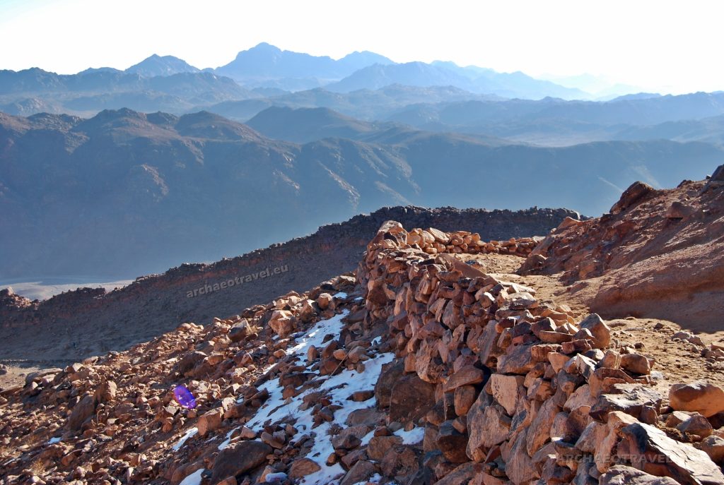
The very last length of the track turned out to be the most challenging of all. The stairs carved out along the path were filled with sharp stones covered in ice, and the slope itself was dangerously steep. Our Egyptian guide was doing his best trying to help us to move forward even if he kept sliding down the rocky steps. When eventually we reached the summit I forgot I was tired, frozen and out of my breath. The view itself was breathtaking …
The sunrise had just started. When the very first rays reached the rusty rocks of the summit, the Sinai Mount shone up reflecting the sunlight. Beneath, the curtains of darkness opened and blazing red landscape appeared to people gathered together at the top. Some were sitting side by side covered in blankets; others were standing up like enchanted columns of rock. Flashes of cameras brightened time after time. While the sun was rising higher and higher, the Sinai mountains uncovered their rugged outlines to the coming day, casting their dark shadows against a rocky desert.
It does not matter if Moses had ever been here. In such moments like that, you can definitely meet God and talk to Him …
Saint Catherine and Her Monastery
And then there left just trekking down. It was much funnier as it was already taken in the warm, Egyptian sun. In front of our eyes desert colours were dancing happily; even usually unmoved camels were pleased with the daylight and surely with the fact they could throw heavy loads away from their backs.
At the end of the way down, we came to the high walls of Saint Catherine Monastery. Built in the sixth century, the monastery is one of the oldest working Ortodox Christian monasteries in the world. It is very famous for its unique collection of Byzantine pre-iconoclastic panel icons that miraculously survived the hard time of religious turmoil on the lands of Byzantium. By the same tradition which leads Moses’ track to the Sinai Peninsula, the Burning Bush from the Bible grows just in here, within the walls of the monastery. According to the narrative, Moses heard the Voice of God who had taken the form of the burning bush not consumed by the flames. At that time Moses was ordered to lead the Israelites out of Egypt to the Promised Land.
Before we stared visiting that religious pearl in the desert, we opened our lunch boxes and enjoyed the silence of monastic atmosphere.
Unexpectedly, Gosia interrupted it thinking aloud: “I feel sorry for Moses” she said seriously “Poor man … he must have been exhausted just walking up and down…”
Egyptian Uprising
Few days before our trekking to the Sinai Mount, at the end of January, 2011, we landed on the airport in Sharm el-Sheikh. On the coach to the hotel I noticed numerous armed soldiers spread out all over the way. Suddenly our coach was ordered to stop by a military. From the perpendicular road a long black limousine went across in front of our coach. Then I found out that inside there was Sajjid Mubarak, the former president of Egypt who was coming back from an emergency summit meeting organized in the face of the situation in Tunisia. A week later while we were crossing Israelite-Jordan border in Eilat, we learned about the Egyptian Revolution that had forcefully burst out in Cairo.
By Joanna Faculties of English Philology, History of Art and Archaeology. University of Silesia in Katowice, Poland; Ecole France Langue, Paris; Cardinal Stefan Wyszyński University in Warsaw, Poland; University College Dublin, Ireland.
BIBLIOGRAPHY:
“The Real Mount Sinai in Saudi Arabia”. In: Revealing God’s Treasure. In: Providence’s Youtube Channel. Accessed on 29th Jun. 2018. Available at <https://bit.ly/3wPg8Jh>.
Amer (2018) “Catching Sunrise at Mount Sinai, Egypt – Breathtaking to say the least”. In: “Mount Sinai Trekking”. In: Where it all begins. Accessed on 29th June, 2018, link unknown.
Vetratoria.com (2018). “The Holy Monastery of the God-trodden Mount Sinai, Saint Catherine’s Monastery”. In: The Holy Monastery of the Mount Sinai. Accessed on 29th June, 2018. Available at <https://bit.ly/3d8zMYQ>.
“Saint Catherine’s Monastery” (2015). In: Wkipedia. The Free Encyclopedia. Accessed on 29th June, 2018. Available at <https://bit.ly/2QeBPle>.
“It is difficult to give an idea of the impression made on the voyager […] by the sight of a ravishing oasis, forming a dazzling band of green, above which rise the crenellated towers, massive bastions, richly crowned with ornamental architecture and fortress walls. If one has a chance to penetrate such a charming place at sunset, it is a veritable fairyland reminiscent of [an oriental] décor. It is a different world opening before us, a curious and strange, made of truly original traditions that make us forget the colourlessness of modern life”.
Wagner Minca 2016:174
On the way southwards
Our journey to the world of refreshing pools and paradise gardens started in Agadir, a famous holiday resort on Morocco’s Atlantic coast, usually fulfilled with the hordes of tourists taking advantage of the sun and endless sandy beaches. We did not stay there long. The following day, we were already on the way to the southern Morocco, driven through the plain of Sous, luxuriantly overgrown with citrus trees and filled with their delicate orange fragrance. The landscape was awash with charming argan trees bending under the weight of mountain goats climbing into their branches. Such a view gracefully builds the picturesque Moroccan landscape. Inspired by traditional Berber methods of production, the argan oil is itself regarded as the gold of Morocco and an essential elixir of youth and beauty.
In the afternoon we reached the fortified city of Tarudant, which had belonged to one of the richest and most powerful cities in all of southern Morocco till the seventeenth century. Apart from majestic, long defensive walls with impressive bastions and gates, my attention was caught by simple but elegant traditional Berber flat roofs made of wood and typically applied in the earthen Moroccan architecture. After leaving Tarudant behind, we followed a scenic route along the Drâa River with its green oases, charming villages and lush palm groves. With each kilometre southwards, red silhouettes of kasbahs were appearing more often on the hills, inviting us to enter their fairyland. Following them like signposts, we continued further along the edge of the Sahara desert and in the foothills of the Atlas Mountains.
Travellers to Kasbah
Throughout Morocco, from the track of kasbahs to the country’s imperial cities, one’s senses seem heightened. They “are teased awake and gently assaulted by the tinkle of water from a fountain, by the heady pungent air of the attarine (spice street) in the souk (bazaar), by the spiced tartness of cracked olives, by the vivid hues of saffron, lapis, amethyst and jade, and by the smooth velvet feel of a long-simmered tagine sauce as it first caresses the tongue” (Crocker 2005:vii)
“Even today, travellers to Kasbah […], who chance upon a sheltered courtyard and pause in the cool shade of a fragrant jasmine or bay tree […] might catch a fleeting glimpse of the sensual delights borne by the Moors [centuries ago]” (Crocker 2005:vii).
The Moors stood initially for the Berbers from Maghreb – the North African countries of Morocco, Tunisia and Algeria (Crocker 2005:vii). Maghreb means the land where the sun sets, as “for the seventh century Arab conquerors, this part of the Mediterranean lay far to the west of their own Damascus, Baghdad and Cairo” (Ibid.:vii).
Berbers
Nowadays, Morocco is a modern Islamic state which is ruled by Arab kings but they rule over the country with a culture and history as diverse as its landscape (Casely-Hayford 2010-2012). Morocco has got its coasts facing the Atlantic and the Mediterranean Sea (Ibid.). Snow-covered peaks of mountains of Atlas range are towering from one side of the country, whereas the bone-dry fringes of the Sahara Desert spreads out from the other (Ibid.). Dominant languages spoken in the country are Arabic, French and Spanish in the north but nearly half the population still speak Berber, the language of the indigenous inhabitants of these lands (Ibid.).
The Berbers’ origins are shrouded in mystery (2006:ix). It is deepened by the fact that members of some tribes have got green or blue eyes and red or blond hair (Medina, Juilleret 2016; New World Encyclopedia 2020). Generally, it is said they are mostly “the remnants of the original inhabitants of North Africa, presently living in Morocco, Algeria, Tunisia and Libya” (Woronof 2006:ix). Still they also live in Mauritania, Mali, Burkina Faso, with smaller minorities in Niger (Ibid.:ix). The word Berber has originated from the Greek barbaroi (Ilahiane 2006:xxx) which described people “who spoke neither Latin nor Greek or to refer to non-Phoenicians within the Carthaginian state. Ancient Greek writers also used ‘Libyan’ as another name to refer to the inhabitants of North Africa while also speaking of other Berbers as the Numidians [– the ‘Nomands’], a name that reflected that most of them practised pastoral nomadism” (Ibid.:xxx). But although the Berbers are usually thought as nomads, the majority are farmers (New World Encyclopedia 2020).
The Berbers describe themselves in their own language as Imazighen (singular Amazigh) (Ilahiane 2006:xxx), which means ‘free men’ (“Berbers” 2020). This is, in turn, perfectly reflected by their flag, where the Yaz (ⵣ) symbol, looking like a man with raised hands, stands for the Berbers motto : ‘Free Man, Free Woman. Free People’ (Ibid.). The symbol is red, which signifies life (Ibid.). Moreover, each colour of the flag “corresponds to an aspect of the territory inhabited by Berbers in North Africa: blue represents the Mediterranean Sea and the Atlantic Ocean” (Ibid.), green stands for nature and yellow for the sands of the Sahara Desert (Ibid.)
Oum (2013) “Taragalte” (Soul Of Morocco) Official Video.
Turning point in history
Whereas, a thousand of years ago, the present lands of Morocco belonged to the Berbers, today, these are the inner parts of the Atlas Mountains and the southern fringes of the desert that remain as predominantly Berber homelands (Chijioke Njoku 2006; Casely-Hayford 2010-2012).
Since ancient times, the Berbers were not unified by a nation-state (Casely-Hayford 2010-2012). Instead, on either side of the Atlas Mountains, there existed small independent Berber clans of farmers, traders and nomads (Ibid.). Although these people had been converted into Islam, they maintained their traditional Berber customs and they did not always follow the new religion to the letter of the law (Ibid.)
In 1050, the situation had drastically changed (Casely-Hayford 2010-2012). This happened because of one Berber man who studied the Quran and became a charismatic, fiery preacher (Ibid.). Idealistic and uncompromising, he had a clear mission to change his fellow Berbers into proper Muslims, schooled in the strict fundamentals of their religion (Ibid.). His travels to Islamic centres of learning had left him a student of a strict legalistic interpretation of the Quran (Ibid.). As such, he has gone down into history (Ibid.). His name was Abdullah Ibn Yasin, the North African religious chief of the Moslem Almoravid movement (Your Dictionary 2010). He ran his converting mission in the Western Sahara, where he pulled together an alliance of tribes and he appointed himself a spiritual leader (Casely-Hayford 2010-2012).
Consequently, from the Sahara Desert, a small group of Nomads came to transform the northwest corner of Africa into a vast empire that stretched from the Sahara to Spain (Ibid.). What started with one man’s mission grew into a kingdom which lasted for centuries (Ibid.). Its rulers generated tremendous wealth, created great architecture and promoted sophisticated ideas in an ordered society (Ibid.).
From Sijilmasa to Awdaghust
In 1054, Abdullah Ibn Yasin became a leader of an army of thousands of nomads who headed for Sijilmasa, one of the most important medieval cities in Africa and a major trading post at the northern edge of the Sahara Desert (Casely-Hayford 2010-2012). Since then, the war described as jihad had started (Ibid.). For Ibn Yasin it was a holy war to uphold a true understanding of Islam but it was also aimed at his fellow Muslim Berbers (Ibid.).
Sijilmasa ruins. Source: Wikipedia. The Free Encyclopedia (2020).
All that is left now of the city of Sijilmasa are but spectacular mud ruins (Casely-Hayford 2010-2012). The city was once built in the middle of one of the largest oasis in Africa and was inhabited by over fifty thousands of people (Ibid.). Date palms and irrigated fields at the site hide clues to a much bigger and more significant past than it is visible today (Ibid.). The taking of the city would be the first major foundation stone of the Moslem Almoravid Kingdom (Ibid.). Dr Eric Ross, an expert in Islamic studies, has been involved in the recent archaeological studies of the site (Ibid.). He says that in the eleventh century, Morocco was not looking towards Europe or the Atlantic but across the Sahara, which was wide open to trade, stretching all the way from West Africa to South Asia (Ibid.). So the city of Sijilmasa itself became a prosperous trading hub of cloth, manuscripts, horses but especially gold coming there from present areas of Mali and Senegal (Ibid.).
Once Ibn Yasin had the city under his control, the Almoravids secured the source of the city’s gold trade (Ibid.). Therefore, they went south to the opposite side of the Sahara and seized the trading town of Awdaghust (today Mauritania) by controlling the supply of gold across the desert (Ibid.). By doing so, they had a virtual monopoly on one of the most lucrative of trades and they could carry on their jihad beyond the Sahara Desert (Ibid.).
We were just approaching the ancient Sijilmasa. Passing by the towns of Tazzarine and Al-Nif, known for fossils mined by the local population, we were lowly moving along one of the most picturesque routes of southern Morocco, in the direction of Erfoud and through Ar-Rajsani, with the most famous souk in the region. In this town, routes begin leading through the Sahara. Along the way, the green swath of palm groves snaked up among fortified villages and Berber granaries, integrated into the landscape of green oases and mountains.
Gate to Sahara Desert
Can you remember the last time you saw a spectacular sunset over the desert?
It was in the small Saharan oasis Merzouga, where Erg Chebbi begins. It is the most popular part of the Sahara Desert in Morocco, with its impressive dunes of pristine sand rising to the height of two hundred and fifty metres and stretching for thirty kilometres around. We rode camels for hours through the gentle golden-orange waves of the desert, climbed up and slid the dunes, enjoying like children golden snowfalls of sand.
With the afternoon coming, dark silhouettes of our caravan, cast against the dunes, were stretching like a ribbon along the way. As we progressed, the colours of the desert kept changing with time from glistening golden-yellow to extremely intense brick-orange with some reddish contours hovering on the horizon. Finally, the camels sat down and we could climbed down our mounts. The sun had slowly started to set sleepily sliding its last lights over the sand. It seemed as if the waning ball was stripping all the desert off colours, leaving us behind among faded and cold hills of sand, in utter silence of the night.
Life-giving katara system
Apart from gold, essential for the successful mission of the Almoravids was also water (Casely-Hayford 2010-2012) and the Berbers “had the knowhow to find and move the scarce resource of water under the arid Sahara desert through katara – a part of the ancient irrigation system made up of a complex network of underground tunnels for funnelling water” (Toa Correspondent 2017). By its means, water could be provided where it was needed across the arid and dry landscape. The whole system is now visible by mounds stretching out across the landscape and it shows the Berbers’ ability to understand their land and work with it (Casely-Hayford 2010-2012).
The system looks on the surface like rows of mole hills but underground it reveals the Berbers engineering knowledge. When we stepped down to the man-made tube-like tunnels, we found ourselves in a parallel world of subterranean caverns and narrow passages, simply lit by the light from the “mole” chimneys opening to the sky. Such was an ancient experience and mastery of the Berbers that they use their katara underground complexes even today.
Across the Atlas Mountains
Finally, with a powerful army, Ibn Yasin had a potential to create an Islamic Berber nation (Casely-Hayford 2010-2012). Yet, before the Almoravids set the foundations for their imperial cities, such as Marrakech, they had to first cross the Atlas Mountains (Ibid.). It was because the Atlas range, rising to over four thousand metres above sea level, has formed a natural border between the desert in the south and more fertile and populous lands in the north, which the army was planning to conquer (Ibid.).
Having traversed the Sahara Desert, we also headed off to the mountains. We took our journey through the Tinghir oasis enclosed by a palm grove, and stopped at the Todra Gorge. Nestled in a surrounding of brick-coloured waves of mountains, the village of Tinghir looks like a mosaic of blue, pink and grey tesserae, scattered between the green swath of palm trees and arid peaks.
“Here, both the Todra and Dadès Rivers have carved out cliff-sided canyons [of several hundred meters long, stretching] through the mountains” (Jackson 2020). The Todra Gorge itself is quite narrow, with its walls rising to around three hundred metres. The river has shrunk so far, allowing “only the imagination to picture the powerful natural forces that once carved this region” (Ibid.). Enchanted by its irresistible magnitude, we spent a while to examine the gorge, and then returned in the area of Tinerhir to enjoy our next Moroccan meal full of colours and spices while “[relishing] this oasis town situated in the heart of an overwhelming fantastic region, [densely covered in] olive, pomegranate, [and] date palms” (Salloum 2020).
Leaving behind one of the most charming landscapes of the southern Morocco, we drove along the Dadès River Valley to the town of El Kelaa de Mgouna. This region is famous for growing the extremely aromatic Rosa Damascena, also known as the Rose of Castile (Brooke 2020). Its exceptional scent hovers in the air of local valleys and is responsible for a “fragrant resurgence of [roses] in perfumes” (Ibid.). Millenia ago, the pre-Saharan valley of the Dadès carried one of the main trade routes through the mountains, which made it attractive also to thieves. Today it overlaps with the so-called Road of a Thousand Kasbahs, “fairy-tale forts, built by magical hands” (Salloum 2020).
Road of a Thousand Kasbahs
By Tinerhir and El Kelaa de Mgouna, we had entered the kingdom of kasbahs and their famous route. The outlines of adobe towers were “to be spotted at every corner […], while speeding 4x4s [moved] between different locations and the next thé à la menthe and couscous aux légumes” (Minca, Wagner 2016:165). Along our way, the fortified castles kept “peeking out of palm groves and edging the roads that cut through the valley” (Rough Guides 2020). They literally dot the landscape of the region (Minca, Wagner 2016:165).
The so-called “kasbah effect” (Ibid.:165) most notably dominates the areas of the great river valleys, namely the already visited Drâa and the Dadès, which encompasses the Route of a Thousand Kasbahs, we were just driving along (Rough Guides 2020). The land of kasbahs consequently covers a vast southern region of Morocco, from the city of Tarudant in the west till “possibly Erfoud at the most extreme eastern tip of this [route]” (Minca, Wagner 2016:165), and includes such cities as Skoura, El Kelaa de Mgouna, Tinerhir, and Boulmane du Dades (Ibid.:165). The itinerary following their monumental castles “hypothetically starts in Ouarzazate, but that is anticipated by the [Ksour] Ait ben Haddou to continue for more than [three hundred kilometres] along the edge of the desert, [till] Merzouga” (Ibid.:165).
Tales of kasbahs
Kasbahs are first of all the significant Heritage of Earthen Architecture in Morocco (Marcus, Smith 2016). There are thousands of fortified earthen complexes and villages, known as kasbahs and ksour, found in southern Morocco (Ibid.). Nowadays, “the Berbers have, with some modifications, retained the fortress-like forms of architecture, [which was in the past] typically constructed to withstand enemy assault” (Chijioke Njoku 2006:66). Like in the painting from an oriental fairy-tale, “the Kasbah is an image of a mud castle in a desert-like landscape, the image exotic and typical of an orientalist idea of the people living at the edge of the Sahara. […] In this sense, the Kasbah is often represented as the ultimate castle in the desert, a fortress perfectly complementing the soft colours tainting the arid landscape” (Minca, Wagner 2016:165).
Kasbahs were “built, in the absence of other available materials, out of [straw] and the mud-clay pisé of the riverbanks. […] They are often monumental in design and fabulously decorated, with bold geometric patterns incised into exterior walls and slanted towers. Seasonal rains wash off some of the mud, so the buildings require constant upkeep – once a kasbah has been left unmaintained, it declines very fast, with twenty years enough to produce a ruinous state if the walls are not renewed” (Rough Guides 2020; see Barriault 2013:35).
Native Berber architecture
The definition of kasbah has got a very wide meaning, “from a fortress isolated in the country to a city neighbourhood, where the members of the administration and the army lived” (Mimó 2020).
However, in southern Morocco, the word kasbah is usually applied to an earthen square structure featuring four towers at the corners (Ibid.) and usually owned by powerful families of viziers (provincial or local governors) or qaids (local judges) (Chijioke Njoku 2006:66). So originally, in the Berber country, the kasbah was a fortified medieval castle, sometimes with the interconnected parts enclosing a village (Chijioke Njoku 2006:66) and “harbouring [its inhabitants] within its bewildering passageways” (Barriault 2013:35). Such functions of the Berbers medieval castles were used especially “[in the era of the Islamic invasions of North Africa and Spain, [when] a fortified section of the kasbah […] was where royal residents sought protection in time of danger” (Chijioke Njoku 2006:66).
Kasbah as an architectural construction is originally “Berber and in this language it is called Tighremt. The word kasbah is recent and linked to the arrival of Arab citizens to areas where there were such monuments” (Mimó 2020). There is yet another definition to describe the Berber architecture, linked to the notion of kasbahs. This is ksar or Ighrem in Berber (Rough Guides 2020). In the Sahara and pre-Sahara valleys of the Atlas Mountains, the Berber population lived within the ksar “which generally refers to fortified and walled villages” (Chijioke Njoku 2006:66; see Mimó 2020). In such a sense, the ksar could include one or a few kasbahs within its walls (Mimó 2020). On the other side, according to other sources, ksar may also stand for “a fortified section of the [kasbah]” Chijioke Njoku 2006:66). However, a ksar (plural, ksour) is usually translated as a walled town with monumental, decorated gates and protected by watchtowers (Mimó 2020). It includes private houses, the mosque and a communal square (Ibid.). Ksour are said to be even more ancient than kasbahs (Ibid.). The oldest kasbahs preserved to our times are dated back to the seventeenth century, however, they may have appeared even millennia ago (Ibid.). There are also some ksour and kasbahs built in the nineteenth century by formerly nomadic tribes (Ibid.).
At the time of the Almoravid expansion, medieval kasbahs were fortified houses, owned and used by Berber wealthy families and merchants (Casely-Hayford 2010-2012). They served “as both residential [but fortified] houses and storerooms” (Chijioke Njoku 2006:66), used to house goods of trade, such as gold and silks, which came across the desert (Casely-Hayford 2010-2012). They had to be fortified because it was a dangerous territory (Ibid.). As such, kasbahs “were built [upon] hills with meandering paths and secret passageways for defence. Enemies were sure to lose their way, defeated by the residents, whose peace the invaders wanted to disturb” (Barriault 2013:35). On the whole, they are magnificent buildings but their fortifications give a sense of what it was like in those days (Casely-Hayford 2010-2012).
Doors to the glorious past
“French academic engagements with kasbahs re-emerged in the decades following the World War I, as waves of rebellion across the Protectorate rescinded and the southern regions became more passable by civilians (Minca, Wagner 2016:171).
Moreover, “the magnificent castles described by nineteenth century travellers [could be already reached by cars]” (Ibid.:171). It also brought “a new wave of researchers on the region – whose focus was the specificity of Berber social organisation and architecture in the timelessness of these untouched and authentic territories. All this investigation was framed as documenting ‘Berber’ life” (Ibid.:172), as opposed to the Arabic culture of the contemporary Imperial Morocco (Ibid.:172). Accordingly, anthropologists describe such architectural structures as kasbahs as non-Arabic (Ibid.:172) and find their roots “delving into ancient global histories like Roman, Greek and the nomadic Sahara. Though they edge towards anthropology, these interpretations are less reflections of use by the inhabitants of kasbahs, and more archaeologies of living monuments, rendering kasbahs into authentic artifacts, even while they are serving as actual living spaces for their residents” (Ibid.:172).
Today, “the adobe ramparts, pathways and doorways [still] retain that majestic mirage [of the Berbers’ glorious past], though very independent homeowners and squatters now inhabit the endless apartments locked within fortified walls” (Barriault 2013:35). For centuries, visitors to Morocco have been “driven by the appeal of these mythical building style. [This is why] they have become an important form of tourist accommodation” (Minca, Wagner 2016:165), sometimes the result of the imaginative conversion of former abandoned or semi-abandoned original structures, which once were real houses (Ibid.:165).
Most prominent of all
Finally, we reached the altitude of 1160 metres above sea level, and the city of Quarzazate or Ouarzazate. It is the capital of southern Morocco, and because of its location, it gives an amazing view of the Atlas range on the horizon. Historically it was the intersection of trans-Saharan trade routes, where the multitude of fortified architecture had escorted us since we left the Sahara Desert and started approaching the mountains.
The most famous of all kasbahs preserved in Morocco is the Kasbah of Taourirt (Marcus, Smith 2016: Salloum 2020). It is located in the city of Ouarzazate and is “considered to be the mother of all kasbahs” (Salloum 2020). The earliest parts of the mud castle date back to the seventeenth century but most of the complex was constructed in the late nineteenth century by Si Hammadi el Glaoui, the ruler of Taourirt and of the powerful Glaoui family, who controlled the southern part of the country (Marcus, Smith 2016; Salloum 2020; see Barriault 2013:35). Si Hammadi expanded the Kasbah from a small group of buildings into a large defensive palace (Marcus, Smith 2016). It included stables, servants’ quarters, workshops, a market, wells and baths, and residences for his wives and children (Ibid.).
Accordingly, the structure encompasses a series of crenelated towers, rising out of a mass of closely packed houses and lavishly ornamented walls with geometric motifs (Salloum 2020). The latter are made with the decorative brickwork technique of hazarbaf, literally meaning ‘thousand weavings’ (Dictionary University 2020). In architecture it is a surface decoration where the exterior wall of the building is geometrically patterned in relief with bricks that create a play of light and shadow (Ibid.). Among the relieved ‘thousand waves’, there are wrought iron bay windows and other intricate traditional architectonic ornamentation, like alfiz, which all adorn the exterior (Marcus, Smith 2016).
The family’s private apartments are particularly richly decorated (Marcus, Smith 2016). Inside the Kasbah, the whitewashed are painted halfway up, whereas the lower parts of the rooms are usually covered in colourful zelligetiles, with the predominance of blue (Barriault 2013:36). Above the windows positioned at the ground level, there are either belts of tiles or stucco friezes running around the room with similar medallions between them. They all are filled with rhythmic linear patterns of arabesque, koranic verses or girth lines decorating the tiles. Ceilings of the private apartments are abundantly carved in cedar wood, subsequently pained in vibrant colours, whereas lesser rooms or passageways are covered with the traditional Berber wooden roofs with visible beams and geometric decorations filling the space between them. We had already observed the very same technique in the wooden roofs of Tarudant and other Berber cities on the way.
All the architectural elements and decorations applied in the Kasbah of Taourirt repeat themselves more or less in other earthly Berber structures, depending on the level of their usage and preservation. It is also worth to note that kasbah elements subsequently influenced and enriched the architecture of the Berber imperial cities, such as Marrakech. It is even believed that an outstanding square-shaped tower of Moroccan minaret (in other Islamic countries, it is usually round), took its origins from the Berber architecture of the kasbah tower. On the other side, the ingenious “Moroccan architecture has been [also] heavily impacted by the Islamic traditions and later European influences. [Modes] of religious worship and rituals, regional histories, and local material, [all that] have combined to give Moroccan architecture a diverse but unique expression” (Chijioke Njoku 2006:65).
Rehabilitation of kasbahs
Unfortunately, kasbahs important and fragile architecture is threatened by abandonment and is being lost (Marcus, Smith 2016). Although the Kasbah of Taourirt was designated a Moroccan national landmark in 1954, it has suffered a gradual deterioration over the years and was mostly abandoned until the 1990s (Ibid.). Currently, it is under the protection of CERKAS, a public institution under the authority of the Ministry of Culture, which aim is to preserve the architectural heritage found in the Atlas Regions and the pre-Saharan Valleys of Morocco (Ibid.). In 2011, the Getty Conservation Institute and CERKAS partnered to develop a methodology for preserving the Kasbah and other sites featuring the earthen architecture in southern Morocco (Ibid.).
Structures in the Kasbah are now being stabilized and restored using traditional earthen construction and conservation techniques (Ibid.). Local materials from Ouarzazate region are being used and skilled craftsmen are training labours in traditional building crafts and techniques (Ibid.). Wall painting conservators are also working inside the richly decorated Caid Residence to preserve and protect important wall paintings (Ibid.). Generally, the rehabilitation of Kasbah Taourirt can serve as a model for conservation of similar earthen sites in the region (Ibid.).
Mud-red fortress
Towering from the edge of the river valley, the Ksar Ait Bin Haddou contains some kasbahs and the most beautiful in all Morocco fortified ochre-coloured Berber village.
The whole complex looks like a massive red bulk of the flat mountain, encrusted with squared houses and sticking towers. Sitting atop a gorge, the fortress is accessible only by donkeys or on foot (Barriault 2013:36). To reach its entrance, we crossed the modern bridge suspended over the nearly dry bed of the Imarene River, which separates the ksar from the neighbourhood town buildings (Ibid.:36). For a moment “we stood in awe, just before beginning the trek upward. There, on low ground, we beheld a huge arched entrance, the same [terracotta-colour] of the imposing kasbah that rose behind it” (Ibid.:36).
Many ksour, like this one, must have existed in Maghreb in the Middle Ages (Ibid.:36). They were cities “unto themselves – slave and villager quarters at the base, the ruling family ensconced in the fort at the top” (Ibid.:36-37). Like in the case of the Kasbah of Taourirt, the family owning the Ksar Ait Bin Haddou was the same “notorious Glaoui clan – a ruling French partisan family during the early twentieth century who completed the fortress” (Ibid.:37). We kept climbing the steep and narrow switchbacks of the ksar, leading past red adobe dwellings to its highest pyramidal-like stepped, mut-rutted terraces (Barriault 2013:37). As we were traversing our footpath, we encountered either goats or donkeys ramming the passageway or the natives selling their goods to passing tourists: colourful paintings, fabrics, herbs and spices (Ibid.:37). Some also offered the tastes of the Moroccan cuisine – a hot smoking tagine, hidden under a conical terracotta cooking pot and surrounded by sweet-smelling with rusted meat and spices (Ibid.:37).
“The higher we climbed, the fewer the inhabitants, the wider the view of the mountainous terrain that crested above the surrounding valley. The brown, barren earth unfolded before us like a forsaken moonscape. Certainly, approaching visitors, hostile or friendly, would be spotted from this height long before they actually arrived. The views of the sweeping mountains that rimmed the bleak plains more than compensated for our efforts to reach the pinnacle that afforded such sights” (Ibid.:37). We were standing there, “elevated above the impoverished lives below us” (Ibid.:37), and listening to the blows of wind sliding down the ridges of mountains. It was high time to go down. Still nobody moved as if enchanted by thousand tales of kasbahs.
Time to cross the mountains
Mysterious Maghreb culture can be compared to its indigenous shelter – the Berber kasbah (Barriault 2013:35). It is at once exotic, inaccessible, misleading but irresistible (Ibid.:35). It appealingly intoxicates our senses with a mystical and elusive essence of the damascene rose petals, drizzled on top of exotic dishes with spicy and herbal flavours; it wraps our skin with the melting velvet of argan oil and dresses it with delicate laces of henna tattoos. At once, it stimulates, clears the mind and brings relaxation.
With each rhythmic strike of a tambourine and magical sounds of Moroccan strings, we stepped back further in fabulous times. The Moroccan journey had led us far to the corners of this semi-abandoned but vibrant spectacle of the past.
“Marrakesh, [and other imperial cities], teeming with seductive life and sunshine, [were always] ahead” (Barriault 2013:37) but we were still lingering between the desert and the mountains, embraced by the arms of red mud-bricked walls.
By Joanna Faculties of English Philology, History of Art and Archaeology. University of Silesia in Katowice, Poland; Ecole France Langue, Paris; Cardinal Stefan Wyszyński University in Warsaw, Poland; University College Dublin, Ireland.
BIBLIOGRAPHY:
“Berber Flag” (2020). In: Wikipedia. The Free Encyclopedia. Available at <https://bit.ly/2xODfKs>. [Accessed 8th May, 2020].
“Sijilmasa” (2020). In: Wikipedia. The Free Encyclopedia. Available at <https://bit.ly/2YMVAm5>. [Accessed 9th May, 2020].
Barriault, A. B. (2013) Moroccan Musings. USA: Xlibris Corporation.
Brooke J. (2020) “The Scent of Rose And Its Fragrant Resurgence In Perfumes.” In: Flower Power Daily.com Available at <https://bit.ly/2YIZRqC>. [Accessed 8th May, 2020].
Casely-Hayford, G. (2010-1012) Lost Kingdoms of Africa Series 2, Episode 4: “The Berber Kingdom of Morocco”. Howitt S., Lilley I., Bates M. IWC Media for BBC.
Chijioke Njoku R. (2006) Culture and Customs of Morocco. Connecticut, London: Greenwood Press.
Crocker, P. (2005) Tastes of the Kasbah. Canada: Riversong Studios
Dictionary University (2020) “Meaning Hazar Baf”. In: Dictionary University. Available at <https://bit.ly/3fySJ66>. [Accessed 8th May, 2020].
Ilahiane H. (2006) Historical Dictionary of the Berbers (Imazighen).Historical Dictionaries of Peoples and Cultures, No. 5. Maryland – Toronto – Oxford: The Scarecrow Press.
Jackson, N. (2020) “Todra Gorge.” In: Atlas Obscura. Available at <https://bit.ly/3bhsUo2>. [Accessed 8th May, 2020].
Marcus, B., Smith, A. (2016) “Kasbah Taourirt: Conserving Earthen Heritage in Morocco”. In The Getty Conservation Institute. Available at <https://bit.ly/3fvNvIv>. [Accessed 8th May, 2020].
Medina F, Juilleret J. (2016) “What evidence of Nordic origin of the Blond Berbers in North Africa?” In: Researchgate. Available at <https://bit.ly/3bk6JNL>. [Accessed 8th May, 2020].
Mimó, R. (2020) “The Route of Thousand Kasbahs”. In: Hotel Tomboctou. Available at <https://bit.ly/3fvqt4l>. [Accessed 8th May, 2020].
Minca C., Wagner L. (2016) Moroccan Dreams: Oriental Myth, Colonial Legacy. London – New York: I. B. Tauris.
New World Encyclopedia writers and editors (2020) “Berber.” New World Encyclopedia. Available at <https://bit.ly/3bcLkpP>. [Accessed 8th May, 2020].
Oum (2013) “Taragalte” (Soul Of Morocco) Official Video. Available at <https://bit.ly/3dwsGe4>. [Accessed 9th May, 2020].
Rough Guides (2020) “Ksour and kasbahs”. In: Rough Guides. Available at <https://bit.ly/3beiS71>. [Accessed 8th May, 2020].
Salloum H. (2020) “From Erfoud to Ouarzazate – It’s Kasbahs Everywhere”. In: Arab America. Available at <https://bit.ly/35MPzHM>. [Accessed 8th May, 2020].
Toa (Correspondent) (2017) “A Stroll through Morocco”. In: TOA. Spotlight Country. Available at <https://bit.ly/2SMEYHr>. [Accessed 8th May, 2020].
Woronof J. (2006) “Editor’s Foreword” In: Ilahiane H. (2006) Historical Dictionary of the Berbers (Imazighen).Historical Dictionaries of Peoples and Cultures, No. 5. Maryland – Toronto – Oxford: The Scarecrow Press.
Your Dictionary (2010) “Abdullah ibn Yasin Facts”. In: Encyclopedia of World Biography. The Gale Group. Available at <https://bit.ly/2yDZaEy>. [Accessed 8th May, 2020].
The matter of pottery and its invention was one of numerous subjects dedicated to Southeast and East Asian Archaeology, which I studied during one of my chosen modules at the university. Although for many scholars the subject of pottery does not seem to tell a compelling story, it turned out to give me a highly interesting insight into general research and the question about the time of pottery’s invention, as according to universal knowledge, its appearance is conventionally associated with the Neolithic, which is, in turn, joined with the high-speed revolution in the development of human kind. Nevertheless, such an idea mostly concerns the area of the Middle East. In Far East Asia countries, such as Japan or China, the subject of pottery should be regarded differently.
Development of pottery has been generally linked to the Neolithic period and primarily associated with the Old Europe and Middle East, with its earliest introduction believed to have occurred in west Asia (Ganj Darreh in western Iran) (circa 7300 BC.) (Rudgley 2000:28; Kobayashi 2004:5, Fig.1.2). In such a context, pottery, together with a craft of weaving, polished stone tools, a sedentary lifestyle (permanent settlements), religion, monuments, and domesticated plants or animals, is still used to describe Neolithic cultures around the world, conventionally appearing around 10000-8000 BC. (Solovyeva 2017:157; The Editors of Encyclopaedia Britannica 2021). Nevertheless, as it is supported by archaeological finds, an invention of pottery had already taken place much earlier, surely in the Palaeolithic, and further eastwards, more precisely in north-east Asia, including the Amur River basin in Eastern Russia (eastern Siberia), China (Jiangxi, a southeast Chinese province) and Japan (Rudgley 2000:28-29; Kobayashi 2004:5, Fig.1.2; Norman 2004-2021).
Yet before 1960, it was believed that the earliest Japanese pottery came back from around 2500 BC. (Omoto, Takeishi, Nishida, Fukui 2016:534). But when the so-called Jōmon pottery from the site of Natsushima (Yokosuka, Kanagawa Prefecture) was radiocarbon dated back to around 7000 BC., it turned out to be a real watershed in the archaeology of prehistory (Rudgley 2000:28). Other contemporary excavations at Fukui Cave in Nagasaki Prefecture not only revealed shreds of pottery, which were around 3000 years older than those from Natsushima (Serizawa 1976:2; Kobayashi 2004:9), but also proved “a direct continuity from [the microlithic culture of] the late Japanese Palaeolithic, [showing] a strong communality with the mainland […], to the [times of the] pottery-using [Jōmon]” (Kobayashi 2004:9,12,14). Further archaeological finds of undecorated pottery fragments in a charcoal residue at the Odai-Yamamoto Site (Sotogahama Town, Aomori Prefecture), pushed the beginnings of Japanese pottery even earlier in time to around 13000 BC. (Jomon Japan 2017). Still the oldest examples of undecorated, simple pottery vessels of the Jōmon culture are said to have been first produced around the same time, at the site of Shinonouchi in Nagano (Cartwright 2017) and at the sites in southern Kyūshū (Kakoinohara in Kagoshima Prefecture) (Kobayashi 2004:15-17,19). At the time of the mentioned excavations, the fact of the earliest pottery finds in Japan simultaneously questioned a common idea about a cultural predominance of ancient China over Japan in terms of innovations (Rudgley 2000:28-29). And although continuous excavations proved that pottery fragments also appeared in eastern Siberia around the same time as the Japanese evidence of earthenware vessels, and even earlier (c. 18 000 BC.) in southern China, pottery of the Jōmon culture in Japan is treated as an archaeological phenomenon and often referred to as the earliest pottery in the world (Norman 2004-2021; Rudgley 2000:29; Kobayashi 2004:5, Fig.1.2,19; cf. Kenrick 1995), though it should be rather called the earliest pottery tradition due to its continuous development over thousands of years (Lewis 23rd September, 2021).
The Jōmon period, which covers a vast expanse of time of approximately thirteenth thousands years (Palmer 2007:49), can roughly fall within the Neolithic time range in Europe or in the Middle East, and so it is usually described as “Japan’s Neolithic period” (MET 2022; see: Solovyeva 2017:157; Kobayashi 2004:5, Fig.1.2; Bleed 1976:107). Still, it is important to mention that at its earliest stages, it overlaps with European and Middle Eastern Palaeolithic and Mesolithic periods (Kobayashi 2004:5, Fig.1.2). Bleed (1976:107) simultaneously claims that describing the entire Jōmon period as Neolithic is actually “unfortunate” and incorrect. Accordingly, if the agricultural revolution constitutes one of the significant aspects recognising the period of Neolithic, the Japanese Neolithic should only refer to the period with the end of the Jōmon culture, between 900 BC. and 300 AD., when the Yayoi culture introduced the agriculture and started to cultivate white rice (Lewis 23rd September, 2021; Kobayashi 2004:133; cf. Barton 2012).
The Jōmon culture is the earliest one that we can identify in Japan. Yet it is little known about it because it was unfamiliar with the writing (Burns 2017). For this reason, the main source of knowledge about it are archaeological finds, such as pottery (Ibid.). Conventional time frames given for the Jōmon culture usually differ, depending on a given source (Cf: Solovyeva 2017:157; Kobayashi 2004:5, Fig.1.2). The chronology shown below is provided by scholars, such as Tatsuo Kobayashi (2004:5, Fig.1.2) and ChungHae Amana Oh (2011:35), and has been established basing on estimated radiocarbon dates from the last decade of the twentieth century (Amana Oh 2011:35). Accordingly, the Jōmon culture spans between 13600 BC. to 900 BC. and is traditionally divided into the subsequent periods: Incipient (13600-9200 BC.), Initial (9200-5300 BC.), Early (5300-3500), Middle (3500-2500), Late (2500-1200 BC.), and Final (1200-900BC.), when the Jōmon style wares and statues were gradually replaced by Yayoi pottery (ChungHae 2011:35, Kobayashi 2004:5, Fig.1.2).
The Jōmon culture came into existence with the end of the Last Glacial Period, and when it was in a gradual process of development, the Global Warming with significant climate change had already begun (Kobayashi 2004:1; Jomon Japan 2017). Consequently, sea levels rose in the contemporary world, causing in the region the inflow of the warm Tsushima Current into the Sea of Japan, and furthermore the growth of abundant forests of beech, chestnut, walnut and acorn in the Japanese archipelago (Kobayashi 2004:19). With time, “the ocean moved further inland, bringing with it [additional wealth] of fish and shellfish” (Jomon Japan 2017). Such favourable climate changes allowed contemporary groups of humans to use and “[manipulate] the resources available to them in the natural environment” (Kobayashi 2004:3). Jōmon groups initially led a nomadic and then a semi-sedentary life (MET 2022; Jomon Japan 2017); at that time, they built their villages composed of “pit dwellings arranged around central open spaces” (MET 2022), mostly along the ocean coast or along rivers and lakes, and obtained their food by gathering and fishing, collecting shellfish and hunting (Jomon Japan 2017). There was no need to move further, as they could dispose a large quantity of natural resources in one place, being usually stored in deep house pits (Kobayashi 2004:21). Kobayashi (2004:21) speculates that Jōmon peoples could have lined their storage pits with clay, as in the case of the West Asian Natufian culture, and so the Jōmon pottery could have originated from Japanese peoples’ observations that protruding fragments of the clay-lining hardened by the heat from nearby ovens (Ibid.:21). Or, there was a case when a piece of clay from the house wall (e.g. Ganji Darehor) or one dropped from the clay lining of a basket (e.g. North American southwest), was accidentally burnt and fire-hardened (Ibid.:21). Consequently, the Jōmon culture could have started processing clay wider to finally use it as a substance for containers (Ibid.:21). Although these are only some of speculations about actual foundations of pottery in Japan (Ibid.:21), they may constitute “a clue to the origins of pottery making in this region” (Ibid.:21).
Gradual increase in temperatures in Japan resulted in further remarkable inventions (Kobayashi 2004:7), such as “adoption of revolutionary new technologies and tools” (Ibid.:7). Typical of the Jōmon culture was an innovative way of cooking by means of pottery, which allowed them with time to initiate a typically sedentary lifestyle (Jomon Japan 2017). Accordingly, greater settlements were established, together with constant residential centres, sometimes featuring graveyards (e.g. Kakinoshima Site, Hakodate City, Hokkaido), and later also impressive monuments in the form of stone circles (e.g. Oyu Stone Circle, Kazuno City, Akita Prefecture or Kiusu Earthwork Burial Circles, Chitose City, Hokkaido) (Ibid.).
According to the archaeological evidence, It is said that groups of people who produced the earliest pottery mainly inhabited the main Japanese island of Honshu, though the centre of the mature Jōmon culture was more likely established in southern Hokkaido and northern Tohoku (northern end of Honshu) (e.g. Irie Takasago Shell Midden, Toyako, Town, Hokkaido or Futasumori Shell Midden, Shichinohe Town, Aomori Prefecture) (Jomon Japan 2017). Such a hypothesis is also supported by the fact that, despite that Honshu and Hokkaido areas had been divided by the Tsugaru Strait, different Jōmon peoples from these areas produced pottery of comparable shapes and by using analogous designs (Ibid.).
The Jōmon pottery was produced by hand, by employing turntables but without the use of a proper wheel, which had been unknown in Japan till the Yayoi phase of development (Kobayashi 2004:77; MET 2022). “The clay was mixed with a variety of adhesive materials, including mica, lead, fibres, and crushed shells, [and when] completely dry, [the pottery] was fired in an outdoor bonfire at a temperature of no more than about 900°C” (MET 2022). Kobayashi (2004:21) compares the earliest Japanese pottery manufacture to a contemporary process of baking a cake of crushed nuts and water. The Jōmon pottery is characterised by a cord pattern and hence the name of the culture – ‘Jōmon’, which stands for a ‘cord design’ (MET 2022). Apart from pottery vessels, also typical of the Jōmon culture were intriguing “[clay] figurines […] and other ritual [objects], demonstrating a rich spirituality” (Jomon Japan 2017). Most recognisable of all are definitely the so-called Dogu. Some researchers believe such pottery clay figures actually represent divine ancestors of the ancient Japanese (Burns 2017).
Shintō, the traditional native religion of Japan based on Japanese mythology, can be translated as the way of gods, literally kami-no-michi, where kami means gods (Shintō 2022). Hence, Japanese people believe in kami celestial beings who are still to reside in modern Japan (Burns 2017). According to an ancient Japanese tradition, there are millions of Kami; each has its own personal characteristics and can inhabit different entities, such as people and animals, or even objects (Ibid.). They come down to earth from Takama-ga-hara (High Plain of Heaven), and inhabit Jinja, which are in the Japanese Shintō religion places of worship devoted to various kami (Ibid.). Kami, in turn, are usually thought to be represented as the Dogu figurines (Ibid.). Around 15,000 Dogu representations in the form of various human-like creatures have been found throughout Japan (Ibid.). Also, according to alternative researchers, Dogu are surely to represent the mythological Kami that visited the earth in ancient times; they have goggle-like eyes and their bodies are covered with rivets, which may indicate an outfit or a type of an armour.
“While the many excavations of Jōmon sites have added to our knowledge of specific artifacts, they have not helped to resolve certain fundamental questions concerning the people of the protoliterate era, such as their ethnic classification and the [actual origins] of their language [and of phenomenal pottery vessels and clay figurines they unceasingly produced]” (MET 2022).
Edwina Palmer (2007:49) suggests that while discussing Jōmon Japanese culture, one should use plural Jōmon peoples as the term should be understood as various groups of “the population spanning at least thirteen millennia across the whole of the present Japanese archipelago”(Ibid.:49). The author also believes “that there is sufficient evidence to suggest that some [Jōmon groups] spoke an Austronesian language or languages” (Ibid.:49). Such assumptions have resulted from a long-term debate on the origins of the Jōmon culture in Japan (Cf. Palmer 2007). Scholars, like Charles Loring Brace et al. (1990) and Peter Bellwood (1997) supported an ‘Out of Taiwan’ hypothesis, postulating that Jōmon culture might have been established by migrations from Taiwan (Palmer 2007:47-49). Simultaneously, it is claimed that in the Jōmon period, some groups travelled by sea from Sundaland (modern-day Southeast Asia) due to a postglacial flooding and eventually settled down on the islands of present-day Japan (Ibid.:47). Even though these two theories seem contradictory, Palmer (2007:47) assumes that “an ‘Out of Sunda’ scenario of migration to Japan in the [Jōmon] period is not necessarily entirely incompatible with an ‘Out of Taiwan’ theory” (Ibid.:47). And so she concludes that there must have been numerous migrations in Japan during a long-time Jōmon period, according to “[a] common-sense approach […] that humans were never traveling in only one direction at any time […]” (Ibid.:48). Such an approach “may, [at the same time], accommodate many aspects of the various theories proposed” (Ibid.:48). Similarly, it is underlined by Ryan W. Schmidt and Noriko Seguchi (2014:43), who claim that the Jōmon culture was rather like an ethnic mosaic composed of various Palaeolithic peoples migrating to the islands of Japan, and so “in this respect, the biological identity of the Jōmon is heterogeneous, and it may be indicative of diverse peoples who belonged to a common culture, known as the [Jōmon]” (Ibid.:43). That, in turn, agrees with the claim that “the [Jōmon] revolution, [creating pottery], did not arise from [an isolated] microlithic culture in the archipelago, nor was it the result of just a single wave of influence from the continent, but rather a [consequence] of several phases of intervention and interaction” (Kobayashi 2004:14). Consequently, there were hypotheses the pottery could have originated in the continental East Asia, invented independently by different groups of people, and then brought with numerous waves of migrations to contemporary Japan and consequently adopted by its inhabitants (Ibid.:19).
The Jōmon pottery is generally distinguished by its characteristics (Cartwright 2017) “that [clearly identify its makers] and [set] them apart from all other [later] Japanese [or contemporary Asian] cultures” (Bleed 1976:107), including the first cases of pottery in Western Asia (Kobayashi 2004:20). A suggested similarity of the Jōmon pottery to examples found in eastern Siberia, China, the Korean peninsula or Taiwan has been challenged, adding to that the pottery in Japan is generally dated earlier than in most parts of contemporary East Asia (except for China and Siberia), where its invention was possibly a result of analogous technologies (Palmer 2007:48; Kobayashi 2004:19; Rudgley 2000:28-29; Norman 2004-2021). Only later, like in the Early Jōmon period, “[similarities] between pottery produced in Kyūshū and contemporary Korea suggest that regular commerce existed between the Japanese islands and the Korean peninsula, [together with the Mainland Southeast Asia]” (MET 2022). It is also theorised that the earliest pottery may have been invented independently in various locations in East Asia, with eastern Siberia, China and the Japanese archipelago in the lead (Kobayashi 2004:20). Moreover, by studying the origins of pottery in Neolithic Middle East, it can be analogically assumed that the Jōmon pottery could also have had a few different foundations (Chosuke in Kobayashi 2004:20).
On the other side, the question of the earliest pottery finds ascribed to the Jōmon culture between the Incipient and Initial periods appears much more complex in terms of its different but subsequential decorative styles (Bleed 1976:108), such as “linear relief, fingernail impression, and simple cord marking” (Ibid.:108). Such pottery remains were usually unearthed further from the said mature Jōmon centre (Jomon Japan 2017), namely, in the area from southern Tohoku to Kyūshū (Bleed 1976:108), which is the region considered “the forefront of the [Jōmon] revolution” (Kobayashi 2004:17). Additionally, it is evident that such early examples of pottery were made by peoples with divergent tools, technologies and skills (Bleed 1976:109). “In sum, […] all the evidence available indicates that during [the Incipient period in Japan, the Jōmon culture] continued to be [highly] complex […], characterized by regionally diverse and distinctive technologies. This kind of complexity and regional diversity is also apparent during the succeeding cultural horizon, [when throughout] central Honshu, fingernail-impressed pottery was [subsequently] replaced by ceramics finished with simple exterior cord marking” (Ibid.:109). Generally, foremost features of the Jōmon pottery and its technological homogeneity are more widely observed only with its later stages (Cf. Bleed 1976), yet, “the population of Jōmon Japan [remained] by no means [anthropologically] homogeneous” (Palmer 2007:49).
In conclusion, the invention and continuity of the Jōmon pottery mostly resulted from the plentiful environment of the Japanese archipelago, together with its effective adaptation and development by independent groups of contemporary humans (Shinpei in: Kobayashi 2004:19; Bleed 1976:113). Kobayashi (2004:20) compares the invention of Jōmon pottery to the so-called ‘springboard principle’, where a technological knowledge of manufacturing earthenware vessels met the actual human needs for such a product (Cf. Kohler in: Kobayashi 2004:20). Yet, apart from being regarded as a product of a technological development, playing mostly a functional role as a container and a cooking vessel, the early Japanese pottery should be equally seen as the beginning of the Jōmon cultural revolution, and so could be interpreted wider, by means of social, economic, religious and artistic ways of expression (Kobayashi 2004:12,22).
Featured image: Reconstruction of the Sannai-Maruyama Site in the Aomori Prefecture. The site shares cultural similarities with settlements of Northeast Asia and the Korean Peninsula, as well as with later Japanese culture, pointing to continuity between ancient and modern Japanese culture. Photo by 663highland (2014). CC BY 2.5. In: ‘Jōmon period’, in Wikipedia. The Free Encyclopedia (2022).
By Joanna Faculties of English Philology, History of Art and Archaeology. University of Silesia in Katowice, Poland; Cardinal Stefan Wyszyński University in Warsaw, Poland; University College Dublin, Ireland.
BIBLIOGRAPHY:
Barton L. (2012). “First Farmers: The Origins of Agricultural Societies by P. S. Bellwood, and: The Peopling of East Asia: Putting Together Archaeology, Linguistics and Genetics ed. by L. Sagart, R. Blench, and A. Sanchez-Mazas, and: The Origins of Pottery and Agriculture ed. by Y. Yasuda (review)”. In: Asian Perspectives, Volume 51, Number 2, Fall 2012, pp. 321-333. The University of Hawaiʻi Press.
Bleed P. (1976). “Origins of the Jōmon Technical Tradition”. In: Asian Perspectives , Vol. 19, No. 1, Japanese Prehistory. University of Hawai’i Press, pp. 107- 115.
Burns, K. (2017). “A Spaceship Made of Stone”, in Ancient Aliens, Season 12, Episode 14. Los Angeles: Prometheus Entertainment.
Cartwright M. (2017). “Jomon Pottery”. In: World History Encyclopedia. Available at <https://bit.ly/3lzAhOU>. [Accessed 18th September, 2021].
ChungHae Oh A. (2011). Cosmogonical Worldview in Jomon Pottery: Comparative Structural Analysis of the Pottery Decorations from the Katsusaka Culture in the Chubu Highlands, Japan (ca. 3,300-2,900 BCE). Nagoya: Sankeisha Co. p. 35.
‘Dogū’ (2022), in: Wikipedia. The Free Encyclopedia. Available at <https://bit.ly/3DhmSVS>. [Accessed 11th September, 2022].
‘Jinja’ (2021), in: Wikipedia. The Free Encyclopedia. Available at <https://bit.ly/3d2yCB0>. [Accessed 11th September, 2022].
‘Jōmon period’, in Wikipedia. The Free Encyclopedia (2022). Available at <https://bit.ly/3d3wOrE>. [Accessed 11th September, 2022].
Jomon Japan (2017). “Jomon Archaeological Sites in Hokkaido and Northern Tohoku”. In: Jomon Japan (Jomon Prehistoric Sites in Northern Japan) Youtube Channel. Available at <https://bit.ly/39lCGXM>. [Accessed 18th September, 2021].
Kenrick D. M. (1995). Jomon of Japan: The World’s Oldest Pottery. London, UK: Kegan Paul International.
Kobayashi T. (2004). Jomon Reflections. Forager life and culture in the prehistoric Japanese archipelago. Kaner S., Nakamura O. eds. Oxford, UK: Oxbow Books.
Lewis H. (23rd September, 2021). “Week 3: Defining the Neolithic: Early pottery, Jomon; East Asian centres of domestication”. In: ARCH30810-Southeast & Asian Archaeology. School of Archaeology. University College Dublin.
MET: Department of Asian Art (2022). “Jōmon Culture (ca. 10,500–ca. 300 B.C.).” In: Heilbrunn Timeline of Art History. New York: The Metropolitan Museum of Art, 2000. Available at <https://bit.ly/3hN0tEB>. [Accessed 18th September, 2021].
Munsterberg H. (1970). “Jomon Pottery”. In: The Arts of Japan. An Illustrated History. Clarendon: Charles Tuttle Publishing.
Norman J. M. (2004-2021). “The Oldest Known Pottery”. In: HistoryofInformation.com. Exploring the History of Information and Media through Timelines. Available at <https://bit.ly/3EMh84Y>. [Accessed 24th September, 2021].
Omoto K., Takeishi K., Nishida S., Fukui J. (published online in 2016). “Calibrated 14C Ages of Jomon Sites, NE Japan, and their Significance”. In: Volume 52 , Issue 2: 20th Int. Radiocarbon Conference Proceedings, 2010, pp. 534 – 548. The Arizona Board of Regents on behalf of the University of Arizona Proceedings of the 20th International Radiocarbon Conference, edited by Jull A. J. T. ed. Cambridge University Press. Available at <https://bit.ly/3hIZpkP>. [Accessed 19th September, 2021].
Palmer E. (2007). “Out of Sunda? Provenance of the Jōmon Japanese”. In: Japan Review, No. 19. International Research Centre for Japanese Studies, National Institute for the Humanities, pp. 47-75.
Rudgley R. (2000). The Lost Civilizations of the Stone Age. New York: A Touchstone Book Published by Simon & Schuster pp. 28-29.
Schmidt R. W., Seguchi N. (2014). Jomon Culture and the peopling of the Japanese archipelago: advancements in the fields of morphometrics and ancient DNA. Japanese Journal of Archaeology 2, (JJA). pp. 34–59.
Serizawa C. (1976). “The Stone Age of Japan”. In: Asian Perspectives, XIX (I), pp. 1-14.
Shintō (2022) in: Wikipedia. The Free Encyclopedia. Available at <https://bit.ly/3BrvlUf>. [Accessed 11th September, 2022].
Solovyeva E. (2017). “Clay Anthropomorphous images of the Jomon Period, Japan”. In: Schwarzberg H. and Becker V. Bodies of Clay : On Prehistoric Humanised Pottery. Oxbow Books, Limited, pp. 157-164.
The Editors of Encyclopaedia Britannica (2021). “Neolithic: anthropology”. In: Encyclopaedia Britannica. Available at <https://www.britannica.com/event/Neolithic>. [Accessed 27th September, 2021].
Archeologia wyspy Jawy wraz z wizytą na Bali. Organizator turystyki, który jest ospowiedzialny za przygotowanie wyjazdu to biuro Ex Oriente Lux – profesjonalny organizator tematycznych wycieczek do Azji.
Wyprawa indywidualna dla 6 – 10/15 osób (w zależności od zainteresowania). Okres wyjazdu: 19 lipca – 1 sierpnia (14 dni na miejscu) – wylot następuje w dniu 18 lipca, a powrót do Polski bedzie 2 sierpnia.
CENA PONIŻEJ
W ramach moich szerokich zainteresowań i studiów leży niewątpliwie archeologia i mitologia Azji Południowo-Wschodniej, szczególnie wydarzenia opiewane przez eposy Ramajany i Mahabharaty, ale także język architektury hinduistycznej i buddyjskiej.
Tym razem zapraszam na wycieczkę w świat bogów i demonów oraz ich architektonicznych siedzib, przez wieki uznawanych przez ludzi za sacrum a przez archeologów i historyków za zagadkę. A to wszystko w transcendencji baśniowych krajobrazów.
DZIEŃ 1: JAKARTA (18.07.23; lot z Warszawy w tym wypadku odbędzie się 17 lipca)
Witamy w Indonezji! Po wylądowaniu w DŻAKARCIE (zachodnia część wyspy Jawa) czekają Was procedury imigracyjne oraz odbiór bagaży. W hali przylotów będzie czekał na Was przewodnik oraz prywatny, klimatyzowany pojazd, którym wyruszamy w 3-4 godzinną drogę na południe, kierując się tym samym w stronę naszego hotelu. Droga wiedzie nas przez chłodny BOGOR, „miasto deszczu”, za sprawą najwyższego poziomu opadów w Indonezji (pada tu ponad 320 dni w roku!), nad którym majestatycznie góruje WULKAN SALAK. Następnie trasa prowadzi przez plantacje herbaty i rejon PARKU NARODOWEGO GUNUNG GEDE PANGRANGO o powierzchni 150 km2, skupionego na dwóch WULKANACH – GEDE i PANGRANGO. Nie trudno zgadnąć, że to właśnie im Park zawdzięcza swoją nazwę. Widowiskową trasę urozmaicimy przerwą na posiłek, relaks w gorących źródłach oraz wizytą u stóp okolicznych wodospadów w okolicy Bogor (w zależności od czasu). Kolację zjemy w rejonie południowego podnóża wulkanu Gede, w przyjemnie chłodnym mieście SUKABUMI (ok. 100 km od Dżakarty), a noc spędzimy w niedużym, 3* hotelu SANTIKA HOTEL SUKABUMI z odkrytym basemen (Superior Room, 25 m2). To świetna baza wypadowa oraz znakomite miejsce, aby zregenerować się po długim dniu aklimatyzacyjnym.
*Free photo source
DZIEŃ 2: BANDUNG (19.07.23)
Po wczesnym śniadaniu czas na wykwaterowanie. Wyruszamy w 2-godzinną trasę do kompleksu megalitycznego GUNUNG PADANG (tłum. “Góra Światła” lub wymiennie “Góra Oświecenia”), którego odkrycie spowodowało sporo zamieszania w powszechnie znanej historii. Tarasy i dziedzińce kompleksu zbudowane są ze skalnych bloków i głazów o wadze 250-600 kg. Nie to jednak stanowi o niezwykłości tego miejsca. Otóż klejone starożytnym cementem ruiny zlokalizowane są na… wzgórzu stworzonym ludzkimi rękami! Archeolodzy dowodzą, że pod spodem kopca o kształcie piramidy czai się najstarsza konstrukcja wybudowana być może nawet 22 000 lat temu przez nieznaną cywilizację sprzed epoki lodowcowej! Oznacza to, że wyprzedziła ona pierwszą znaną cywilizację Mezopotamii o blisko 15 000 lat, a Göbeklitepe o 10 000 lat … Zapraszamy na spacer, który ukaże podobieństwo Gunung Padang do peruwiańskiego Machu Picchu, a także unaoczni rozległość terenu, który jest kilkakrotnie większy od świątyni Borobudur. Porozmawiamy również o kontrowersjach wokół Góry Światła – jak choćby o ofercie kupna praw do tego terenu wartej 1 miliard dolarów amerykańskich. Mówi się, że rząd Indonezji odrzucił tę propozycję licząc, że plotki o złocie ukrytym w piramidzie nie są jedynie plotkami. Gdy emocje nieco opadną, skierujemy się na lokalny lunch oraz w kierunku aktywnego WULKANU TANGKUBAN PERAHU (tłum. “Odwrócona Łódź”, ze względu na kształt góry), skąd rozpościera się oszałamiający widok na region BANDUNG. Następnie wizyta w kalderze wulkanu z wyjątkową panoramą krateru oraz (jeśli czas pozwoli) wizyta w kolejnych gorących źródłach w CIATER, aby odpocząć w ciepłej, siarkowej wodzie lub wizyta na lokalnym targowisku w miejscowości CIWDEY. Kolacja i nocleg w pobliżu KRATEROWEGO JEZIORA KAWAH PUTIH – CIWIDEY VALLEY RESORT & HOT SPRING WATERPARK, BANDUNG (Superior Room, 25 m2).
Przed nami kolejne wczesne śniadanie, wykwaterowanie i wyjazd. Drogę umilą nam aromatyczne truskawki, „popisowy numer” tutejszych rolników. Na celowniku mamy KAWAH PUTIH (tłum. “Biały Krater”) ze swym emblematycznym jeziorem o wulkanicznym rodowodzie. Naszym zdaniem jego kolor bliższy jest turkusowi i może zmieniać się w zależności od zawartości siarki. W słoneczne dni kolor jeziora jest surowy i jasny, a w pochmurne cały krater może być spowity mgłą, co zapewnia równie niesamowite doznania. Niezależnie od palety barw hipnotyzujący widok uśpionego krateru jest jednym z najbardziej niezapomnianych przeżyć z Jawy. Posileni lunchem wyruszamy w stronę centralnej Jawy, do PEKALONGAN. 6-7 godzinną trasę pokonujemy klimatyzowanym pojazdem, rekompensując sobie w ten sposób brak połączenia lotniczego na trasie Bandung – Jogjakarta. Do Pekalongan docieramy wieczorem, w samą porę na pożywną kolację i nocleg w hotelu 3* SANTIKA PEKALONGAN (Superior Room, 22 m2), na skraju Morza Jawajskiego.
DZIEŃ 4: YOGYAKARTA (21.07.23)
Po śniadaniu wykwaterowanie i wyjazd z Pekalongan. Upewniamy się, że mamy pod ręką kurtkę przeciwdeszczową, ciepłą bluzę i czapkę, dzięki którym nagłe zmiany warunków atmosferycznych na wysokości 2 300 m n.p.m. nie będą bolesne. Kierowca zabiera nas w malownicze okolice płaskowyżu DIENG (tłum. “Siedziba Boga”), w którym zakochują się wszyscy miłośnicy przyrody. Droga urozmaicona meczetami, wioskami, tarasami ryżowymi na stromych zboczach, plantacjami owoców i warzyw zajmie nam ok. 2-3 godzin. Na dnie kaldery zobaczymy jedne z najstarszych indonezyjskich świątyń, które zostały odkryte przez archeologów w wyniku osuszania gigantycznego jeziora. To nie tylko najstarsze zabytki kultury jawajskiej, ale przede wszystkim jedno z najpiękniejszych miejsc w Indonezji! Mistycyzmu dodają mu aktywne wulkany, na których w VII w. zbudowano świetnie prosperujący, górski kompleks świątynny, o który dbali hinduscy kapłani i pustelnicy. Spędzimy czas nad JEZIOREM TELAGA WARNA, którego kolor wody zmienia się w zależności od czasu, pogody i perspektywy. Wspólnie polować będziemy na moment, w którym woda przybierze fenomenalną, szmaragdową barwę, bowiem o kolorach decyduje załamanie światła osadów siarki, które zalegają na dnie kolejnego, spektakularnego jeziora. Po przerwie na lokalny lunch wyruszamy do YOGYAKARTY (Jogjakarty) (4-5 godzin drogi) – kulturowego centrum wyspy. Zakwaterowanie w GALLERY PRAWIROTAMAN YOGYAKARTA (Deluxe Room, 35 m2), kolacja i odpoczynek.
*Free photo source
DZIEŃ 5: BOROBUDUR & BALLET SHOW (22.07.23)
Po śniadaniu dzień, na który wszyscy czekaliśmy z nutką ekscytacji. Przygotowujemy niewielkie plecaki, wodę oraz nakrycie głowy i wyruszamy na spotkanie z historią starożytnej Jawy. Główną atrakcją dnia są obiekty wpisane na listę światowego dziedzictwa UNESCO, czyli BOROBUDUR – największa na świecie świątynia buddyjska oraz pobliski PRAMBANAN – imponujący kompleks świątyń hinduistycznych, które swoją wspaniałością mogą konkurować nawet z Angkor Wat. Sąsiedztwo obydwu świątyń będzie przyczynkiem do rozmowy o harmonii i tolerancji. Opowieść rozpoczniemy od zaznajomienia się z nazwą „candi”, którą w języku indonezyjskim określa się świątynie hinduskie i buddyjskie. Candi Borobudur to świątynia z przełomu VIII/ IX wieku. W jej piramidalnej konstrukcji odzwierciedlona jest buddyjska wizja świata. Przez niektórych określany jako mistyczny – krajobraz kilkudziesięciu posągów Buddy, zamkniętych w stupach i ułożonych na planie mandali, którego tłem jest porośnięta dżunglą równina Kedu z wystającym na horyzoncie stożkiem wulkanu Merapi. Prambanan to hinduistyczny kompleks z IX w. Pierwotnie liczył 232 obiekty architektoniczne ułożone na planie trzech wielkich czworokątów, które zostały poważnie uszkodzone przez trzęsienie ziemi za sprawą wybuchu Merapi. Świątynie z Prambanan zniknęły wówczas na tysiąc lat, przysypane pyłem wulkanicznym. Porośnięte lasami czekały cierpliwie, bowiem dla bogów czas przecież nie istnieje. Mieszkańcy Jawy nie odważyli się ruszyć kamieni przez stulecia, bo wierzyli, że wszystkiego pilnują demony. Obejrzymy zatem największy i najbardziej znany kompleks hinduistyczny leżący poza granicami Indii. Posłuchamy o kulcie 3 bogów – Śiwie (Bóg Niszczyciel), Wisznu (Bóg Utrzymujący Świat) i Brahmie (Bóg Stworzyciel), analizując detale ozdobnych reliefów inspirowanych scenami z Ramajany – największego hinduistycznego eposu. Kolejnym przystankiem na tym samym obszarze będzie piękna, choć mało znana, królewska świątynia – CANDI SEWU (tłum. “Świątynia Tysiąca”), druga co do wielkości świątynia wyznawców Buddy na Jawie (tuż po Borobudur). Mówi się, że dawniej otoczona była ponad tysiącem mniejszych stup, stąd wzięła się jej nazwa, jednak archeolodzy doliczyli się 249 pomniejszych świątyń. Zajrzymy jeszcze do buddyjskiej świątyni CANDI PLAOSAN z IX stulecia, składającej się z dwóch bliźniaczych kompleksów. Legenda mówi, że tłem powstania Plaosanu było wielkie uczucie pomiędzy hinduskim księciem i buddyjską księżniczką, których do końca życia nie rozdzieliła religia. Wejścia do świątyni strzegą 4 potężne postacie, przypominające uzbrojone ogry – to wojowniczy dvarapala, czyli strażnicy drzwi lub bramy, dość powszechny element architektoniczny w kulturze hinduskiej i buddyjskiej. W zależności od wielkości i zamożności świątyni strażników ustawiano pojedynczo, w parach lub w większych grupach. Mniejsze budowle mogły mieć tylko jednego dvarapala. Po lunchu czas na ostatnią świątynię na naszej dzisiejszej trasie. Niewielka w porównaniu z Borobudur, buddyjska CANDI MENDUT, szczyci się trzema 3-metrowymi posągami. Wewnątrz ruin z chłodnego mroku wyłonią się trzy monumentalne rzeźby przedstawiające mistyczne ciała Buddy – sami wówczas zobaczycie, że Cewi Mendut jest niesłusznie omijana przez odwiedzających, ponieważ tutejsze rzeźby są arcydziełami na światową skalę. Wieczorem zapraszamy na kolację z set menu (18:30) oraz na wyjątkowy spektakl, który odbędzie się w amfiteatrze pod gołym niebem (w okresie pory suchej, czyli maj – październik; obowiązują 3 klasy biletowe; 19:30 – 20:30). Na naszych oczach odegrany bedzie taneczny dramat RAMAJANA BALLET – czyli interpretacja sanskryckiego eposu „Dzieje Ramy” o indyjskich korzeniach. Godzinne przedstawienie to znakomite połączenie choreografii, muzyki i zachwycających kostiumów blisko 200 tancerzy. Tancerze i aktorzy wystąpią dla nas na tle oświetlonej świątyni Prambanan. By mieć pewność, że nie poczujecie się zagubieni, przed rozpoczęciem spektaklu nakreślimy jego fabułę, a także podpowiemy na co zwrócić szczególną uwagę. Druga noc w GALLERY PRAWIROTAMAN YOGYAKARTA (Deluxe Room, 35 m2) i czas na regenerację po aktywnym dniu.
DAY 6: ŚWIĄTYNIA RATU BOKO & CANDI CETO (23.07.23)
Po śniadaniu wykwaterowanie i przejazd do ruin RATU BOKO, których funkcja do dziś pozostaje zagadką. Niektórzy eksperci sądzą, że miejsce miało character religijny, inni zaś upatrują w nim ufortyfikowany pałac królewski z wyraźną pozostałością murów obronnych. Dzięki położeniu na zboczu wzgórza rozpościera się stąd piękna panorama Prambanan i WULKANU MERAPI – tło, które aż się prosi, by uwiecznić je na zdjęciach. Wyruszamy na zachód wyspy, w kierunku CANDI CETO. Po drodze postój na lokalny lunch, następnie około 3 godz. drogi z okazją do degustacji tutejszych owoców egzotycznych. Uprzedzamy, że droga do jawajsko-hinduskiej świątyni Candi Ceto jest wymagająca – złośliwi mówią, że tylko dla ludzi o mocnych nerwach, bo pnie się stromo w górę wzdłuż wysokich klifów. Pora przyodziać się w coś cieplejszego, bo Candi Ceto wzniesiono na zboczu STRATOWULKANU GUNUNG LAWU, na wysokości blisko 1 500 m n.p.m. Świątynia do złudzenia przypomina obiekty, które znać możemy z Bali. Dysponuje kilkoma tarasami, z których najwyższe są niedostępne dla odwiedzających, bowiem Candi Ceto wciąż pozostaje aktywnym miejscem kultu religijnego. Warto pamiętać, że Gunung Lawu stanowi także umowną granicę pomiędzy Centralną a Wschodnią Jawą, którą przekroczymy już jutro. Nocleg w SUKUH COTTAGE NEAR CANDI SUKUH (Standard Room, 16 m2).
*Free photo source
DAY 7: ŚWIĄTYNIA CANDI SUKUH & MT. BROMO (24.07.23)
Stałym zwyczajem tuż po śniadaniu wykwaterujemy się, będąc gotowi do drogi w stronę pobliskiej, hinduistycznej świątyni CANDI SUKUH, określanej mianem „erotycznej świątyni”. Ukryta w lesie, pozwoli nam odbyć krótki trekking nim dotrzemy do piramidy z grubo ciosanego kamienia, która przywodzi na myśl budowle Majów z terenów dzisiejszego Meksyku i Ameryki Centralnej. Przed nami trzypoziomowa architektura z XV w. ulokowana na zachodnim zboczu góry Gunung Lawu. Zagadkowa, odizolowana świątynia słynie ze swych płaskorzeźb, na których większość postaci jest naga od pasa w dół. Genitalia są przedstawione na kilku posągach, co jest dość rzadkie wśród klasycznych zabytków jawajskich. Niektórzy tłumaczą to historią powstania świątyni. Była ona bowiem wybudowana w czasie, gdy na Jawie toczyły się walki o władzę między muzułmanami, którzy zajmowali północ wyspy, a hindusami, którzy przeważali na południu. Miecze i penisy miałyby symbolizować hinduistyczne zwycięstwo z powodu większej męskości. „Erotyczna świątynia” będzie głównym tematem rozmów podczas lunchu, natomiast tuż po nim wyruszamy w długą drogę do aktywnego WULKANU BROMO – jednego z najsłynniejszych wulkanów w całej Indonezji. Zajmie nam to ok. 7-8 godz., które urozmaicimy historiami o starożytnej i dzisiejszej Jawie. Zmieniający się krajobraz umili nam najdłuższy z transferów na naszej trasie. Dzisiejsza noc będzie krótka, ze względu na wczesną pobudkę i obserwowanie wschodu słońca nad Bromo, dlatego po kolacji zachęcamy do porządnej regeneracji. Zakwaterowanie i kolacja w CEMARA INDAH HOTEL NEAR MT. BROMO (Standard Room, 18 m2), możliwie najbliżej punktu startu jutrzejszej eskapady.
DAY 8: WSCHÓD SŁOŃCA NAD WULKANEM BROMO (25.07.23)
Przygotowani na chłód i wiatr, wyruszamy już o 3:00 – 3:30. Mrok nocy przecinają wiązki światła naszych samochodów terenowych. Kierujemy się do PARKU NARODOWEGO BROMO TENGGER SEMERU, a dokładniej w stronę zbocza Mt. Penanjakan, do najpopularniejszego punktu widokowego. Czeka nas krótki, acz intensywny spacer z latarkami lub czołówkami z parkingu do najwyżej położonego punktu widokowego “King Kong Hill” (ok. 15 min) lub „Seruni Platform” (mniej popularnego). Warto być jednak przygotowanym na nieprzyjemne warunki atmosferyczne, przede wszytskim chłód. Już za moment niebo zacznie płynnie zmieniać kolory, szykując dla nas jeden z popisowych spektakli Matki Natury. Z ciemności wyłonią się kolejno trzej kompani – WULKAN BATOK (2 470 m n.p.m.), BROMO (2 329 m n.p.m.), SEMERU – najwyższy szczyt Jawy (3 676 m n. p. m.) oraz kilka mniej popularnych wulkanów i kalder znajdujących się na terenie parku. Z każdą minutą ich zbocza będą mienić się coraz cieplejszymi barwami. Uroku temu pocztówkowemu krajobrazowi dodaje położenie Bromo. Wulkan znajduje się wewnątrz masywnej kaldery Tengger (krater wulkaniczny o średnicy około 10 km), otoczonej morzem jasnego piasku wulkanicznego. Nim oddalimy się w stronę hotelu i śniadania, przejedziemy w pobliżu krawędzi Bromo, a chętni będą mogli przespacerować się po wulkanicznym pyle i wykorzystać poranne światło do fantastycznych ujęć. Uwaga: najlepszą przejrzystość powietrza i szansę na podziwianie panoramy Parku Narodowego niesie ze sobą okres od kwietnia do października. Wracamy do hotelu, aby sprawnie zjeść śniadanie, spakować bagaże i wyruszyć na lotnisko w Surabaya (ok. 4 godz.), skąd odlecimy do Denpasar (Bali). Po drodze przerwa na lunch lub posiłek na lotnisku (w zależności od zapasu czasu). Pożegnanie z polskojęzycznym, jawajskim przewodnikiem i check-in na przelot na Bali – wyspę, o której mawia się, że zagęszczenie świątyń to 4 budowle na 1 kilometr kwadratowy! Lądujemy na BALI, odbieramy bagaże i witamy się z kolejnym polskojęzycznym przewodnikiem. Kierujemy się wspólnie do komfortowego, kameralnego hotelu SOL BENOA BY MELIA 4* (Sol Room, 50 m2) z dostępem do dość szerokiej plaży ze złotym piaskiem. Trasa do hotelu zajmie nam ok. kilkunastu minut dzięki niedawno wybudowanej, płatnej drodze ekspresowej. Kolacja we własnym zakresie – w hotelu, w jednej z pobliskich restauracji lub w punktach ze street-foodem do których z łatwością można dotrzeć pieszo wybierając się na spacer poza kompleks hotelowy. Uwaga: w przypadku zmian w programie lub jeśli wyda się to Wam zasadne, na Wasze wyraźne życzenie możemy wykupić pakiet all-inclusive 24/7. Pakietu nie możemy rezerwować na wybrane dni, może obowiązywać wyłącznie przez cały czas trwania zakwaterowania.
*Free photo source
DAY 9: BALI HIGHLIGHTS (26.07.23)
Wczesne śniadanie oraz spotkanie z przewodnikiem, który porwie Was w drogę na północny zachód Bali oraz na kolację i zakupy w UBUD. Przed nami kolejny, intensywny dzień. Na początek ok. 2 godz. trasy wiodącej przez wioski i zielone tarasy ryżowe. Prawie na pewno napotykamy przynajmniej kilka procesji religijnych (pogrzeb, ślub lub cykliczne lokalne ceremonie) – szybko przekonacie się wówczas, że Bali jest jak jeden wielki plener fotograficzny! Odwiedzimy PURA BESAKIH na zboczu świętej GÓRYAGUNG, zwaną „Matką Wszystkich Świątyń”. Ze względu na to, że jest to najważniejsza świątynia, celebrowane są tutaj liczne święta – około 70 w ciągu 210 dni balijskiego kalendarza. Znajdziemy się na wysokości ok. 1000 m n.p.m., aby zwiedzić cześć z zespołu 23 świątyń i mniejszych sanktuariów. Najważniejszym miejscem jest PURA PENATARAN AGUNLEMPUYANG, do której można się dostać po pokonaniu wysokich schodów i przejściu przez “candi bentar” (rozszczepioną bramę). Przyjrzymy się ołtarzom dedykowanym hinduistycznej trójcy – Trimurti. Ołtarze udekorowane są na różne kolory odpowiadające konkretnemu bóstwu. Biały to kolor Sziwy, czerwony Brahmy, a czarny Wisznu. Następnie pora na górzysty region KINTAMANI z emblematycznym, masywnym wulkanem i KRATEREM BATUR, jeziorem o tej samej nazwie i okolicznymi dolinami. Jeśli pożywny lunch i aromatyczna kawa z tutejszej plantacji, to koniecznie z widokiem na wulkan! Zatrzymamy się w malowniczej wiosce na krawędzi krateru na szereg balijskich specjałów i kolejną porcję zdjęć. Po ok. 1 godz. przejździe znajdziemy się w pobliżu Ubud, a dokładniej mówiąc w GUNUNG KAWI – kompleksie grobowców i świątyń rodem z XI wieku. To jedno z najbardziej fascynujących stanowisk archeologicznych na Bali. Otoczone polami ryżowymi, częściowo pochłonięte przez dżunglę, sprawia wrażenie opuszczonego i niedostępnego miejsca. Gunung Kawi obejmuje grupę 9 królewskich nagrobków, wykutych w skalistych klifach po obu stronach wąwozu świętej rzeki Pakerisan (która dalej niespiesznie płynie do świętych źródeł wody w pobliskiej świątyni TIRTA EMPUL, jednej z najsłynniejszych i nie bez kozery najładniejszych miejsc na wyspie). Zobaczymy je pod warunkiem pokonania 370 schodów, które doprowadzą nas do zacisznego miejsca pośród skał. Tu bije ogromna energia niosąca ze sobą harmonię. Przed wejściem na teren kompleksu mija się szpalery sklepików z całym swym dobrodziejstwem – wygospodarujemy nieco czasu na zakupy, na które pojawi się także szansa w Ubud. Pół godziny później jesteśmy już w leśnym parku „Monkey Forest Sanctuary”, na spacerze w towarzystwie zuchwałych makaków. Pilnując okularów i plecaków niespiesznie maszerujemy do XIV- wiecznej świątyni DALEM AGUNG PADANGTEGAL, wzniesionej ku czci bogini śmierci, Durgi. W międzyczasie pojawią się kolejne okazje do zakupu rękodzieła (m. in. wiklinowych torebek, łapaczy snów, kadzideł, ubrań i dodatków) w sklepikach z mydłem i powidłem oraz na pchlim targu w Ubud. Czas wolny warto przeznaczyć na samodzielną kolację w wybranej przez siebie (lub rekomendowanej przez nas) restauracji, następnie wspólny spacer przez Ubud w stronę naszego pojazdu. Po zmroku wracamy do hotelu SOL BENOA BY MELIA 4* (Sol Room, 50 m2).
DAY 10: CZAS WOLNY (27.07.23)
Dzień, który zawsze niesie ze sobą wiele frajdy – czas wolny, który można spędzić we własnym stylu. Awanturnikom i niespokojnym duchom pomożemy zorganizować dodatkową, indywidualną wyprawę np. całodzienną eskapadę na słynną wyspę NUSA PENIDA z okazją do snorklowania i plażowania; CEREMONIĘ OCZYSZCZENIA w wybranej, balijskiej świątyni; wyprawę w okolicę UBUD, by przespacerować się przez tarasy ryżowe i spędzić dzień w Jungle Beach Barze; masaż i zakupy w modnych dzielnicach Bali. Lunch i kolacja we własnym zakresie. Kolejna noc w hotelu SOL BENOA BY MELIA 4* (Sol Room, 50 m2).
*Free photo source
DAY 11: PODRÓŻ NA FLORES & LABUAN BAJO (28.07.23)
Kolejna zmiana adresu. Dzień rozpoczynamy śniadaniem w hotelu, wykwaterowaniem i przejazdem na lotnisko w Denpasar. Stąd o 10:20 wyruszamy w rejs liniami Batik Air do LABUAN BAJO na wyspie FLORES (czas przelotu ok. 1 godz.; możliwe są późniejsze połączenia, aby wykorzystać czas na Bali), meldując się na miejscu już o 11:30. W trakcie całej podróży towarzyszy polskojęzyczny przewodnik. Przejazd na lunch z zimnym piwem oraz check-in w hotelu w Labuan Bajo. Czas wolny na basenie, na plaży lub w mieście. Samodzielna kolacja w restauracji hotelowej lub poza miejscem zakwaterowania. Zakwaterowanie w PURI SARI BEACH HOTEL 3* z bezpośrednim dostępem do plaży.
DAY 12: KOMODO NATIONAL PARK – CZĘŚĆ 1 (DLA CHETNYCH – DODATKOWO PLATNE) (29.07.23)
Po śniadaniu wyruszamy na prywatną eksplorację PARKU NARODOWEGO KOMODO – jednego z najbardziej oryginalnych, a przez to najciekawszych parków we wschodniej Azji, nie na darmo wpisanym do „7 Nowych Cudów Natury”. Zobaczymy wszystkie miejsca, które przyciągają turystów z całego świata niczym magnes, pamiętając przy tym, że na PN Komodo składa się aż 30 wysp! Przygotowujemy ręczniki, stroje kąpielowe i kremy z filtrem, łapiemy wiatr w żagle i cumujemy przy KELOR ISLAND, aby jeszcze przed słońcem w zenicie wdrapać się na tutejszy punkt widokowy dla wspaniałej, niemal katalogowej panoramy – na horyzoncie okoliczne wyspy, wszelkiej maści łodzie i turkusowa woda. Na dole czeka na nas poczęstunek oraz czas na pierwsze snorklowanie. Uwaga: podłoże jest kruche I kamieniste, dlatego podczas wspinaczki przydadzą się zakryte, dobrze trzymające buty sportowe z bieżnikiem. Nim zrobi się okrutnie gorąco, a my poczujemy się jak w terrarium, cumujemy przy słynnej RINCA ISLAND, jednego z dwóch adresów waranów z Komodo. Wyruszamy w trwający blisko godzinę trekking po sawannie w towarzystwie lokalnych rangerów, aby na własne oczy spotkać endemiczne, 3-metrowe smoki z Komodo ze skórą niczym zbroja. Jak to z naturą bywa, możemy napotkać ich kilka lub wcale, ospałe lub aktywne. Na wyspie Rinca żyje ich ok. 1050 sztuk na 198 km2 (na Komodo ok. 1 700 sztuk na 390 km2; źródło: BBC 2020, dane na 2018 r., brak aktualnych danych na temat populacji w podziale na wyspy). Szlaki trekkingowe mają różne poziomy trudności i długość. Czas na schłodzenie się w orzeźwiającej, krystalicznie czystej wodzie, następnie lunch z przekąskami z grilla oraz zimne piwo na łodzi. Na kolację i nocleg wracamy do hotelu PURI SARI BEACH HOTEL 3* z bezpośrednim dostępem do plaży. Samodzielna kolacja w restauracji hotelowej lub poza miejscem zakwaterowania.
DAY 13: KOMODO NATIONAL PARK – CZĘŚĆ 2 (DLA CHETNYCH – DODATKOWO PŁATNE) (30.07.23)
Przed nami kolejny dzień na terenie PN Komodo, dlatego wypływamy skoro świt. Po najpiękniejszą panoramę regionu wyruszamy na PADAR ISLAND, przytulnie umiejscowioną pomiędzy Rinca a Komodo. Jest tu naprawdę bajecznie, a tej panoramy po prostu nie wypada przegapić. Wspinaczka zajmie nam ok. 20-40 minut, na szczyt wiedzie całkiem komfortowa, betonowa trasa ze stopniami i kamieniami. Nie ma roślin czy wzniesień rzucających cień, więc zawsze maszeruje się tu w pełnym słońcu. Po drodze pojawia się wiele punktów widokowych na których możemy poprzestać, ale te najbardziej spektakularne są na samym szczycie. Cumujemy przy niewielkiej wyspie KOMODO, gdzie na dość rozległym, leśnym terytorium (390 km2) żyje blisko 1700 waranów. To nasza drugie podejście na wypadek gdyby wizyta na Rinca skończyła niepowodzeniem, a Wami targały mieszane uczucia. Rezerwujemy czas na lunch, zdjęcia i snorklowanie na rafie przy PINK BEACH, której kolor nadają małe cząsteczki czerwonego koralowca. Przed zachodem słońca kierujemy się na wyspę Kalong, by pokazała nam kolejny cud Parku – zrywające się do lotu „latające lisy”, które o zmierzchu wyruszają na sąsiednie wyspy w poszukiwaniu jedzenia. Olbrzymia kolonia niegroźnych dla człowieka nietoperzy na tle wielobarwnego nieba wygląda jak wielka migracja ptaków. Na kolację i nocleg wracamy do hotelu PURI SARI BEACH HOTEL 3* z bezpośrednim dostępem do plaży. Samodzielna kolacja w restauracji hotelowej lub poza miejscem zakwaterowania.
Brama niebo przy świątynii balijskiej PURA PENATARAN AGUN LEMPUYANG z widokiem na wulkan o zmierzchu
*Free photo source
DAY 14: POWRÓT NA BALI (31.07.23)
Śniadanie w hotelu, wykwaterowanie i wyjazd w kierunku lotniska Labuan Bajo. W towarzystwie polskojęzycznego przewodnika lecimy do DENPASAR, na Bali (wylot rejsem linii Batik Air; czas przelotu: ok. 1 godz.), skąd kierujemy się na pożegnalny lunch. Wybraliśmy dla Państwa miejsce, które robi wrażenie tak na gościach, jak na nas samych. Beach bar z pięknym designem, smacznym jedzeniem, kolorową mieszanką gości – La Brisa Beach Restaurant Canggu w rejonie SEMINYAK, słynącego z dobrych restauracji, modnych barów i klubów. Dla chętnych czas na zakupy oraz 60-minutowy masaż ciała w PRANA SPA, który rozluźni Was przed podróżą. Transfer na lotnisko uzależniamy od ostatecznej godziny Waszego wylotu.
POŻEGNANIE Z GRUPĄ I PODZIĘKOWANIE ZA WSPÓŁPRACĘ
Wycieczka oparta na scenariuszu Archaeotravel.eu organizowana przez Biuro Podróży: Ex Oriente Lux dla 10 osób.
Wycena w grupie 10 osób wygląda następująco:
– 3750 USD za 1 osobę z uwzględnieniem Parku Komodo – 2650 USD za 1 osobę bez uwzględnienia Parku Komodo
Obecnie na wyspie Rinca nie można korzystać ze szlaków trekkingowych, ale jest szansa zobaczyć warany w niedalekiej odległości od domku strażników. Tak czy inaczej okazja do oglądania waranów będzie miała miejsce jeszcze na wyspie Komodo, bo Państwa wizyta w Parku planowana jest na 2 dni.
Like two months before Christmas, 2018, a group of three archaeology students started to conduct a thorough archaeological survey of Ballyedmonduff wedge tomb in Co. Dublin, in order to gain a better understanding of the site. I was one of them. Although we were not allowed to do proper archaeological digs, we documented instead the archaeological remains in detail, including research of the folklore surrounding the so-called ‘Giant’s Graves’ as the wedge tomb of Ballyedmonduff is usually called (McGuire et al. 2019:3). Before the date of submitting the project, in February, 2019, we visited the site a number of times. “The tomb itself is marked on the Park’s map, as the ‘Giant’s Grave’ [and] is situated on land owned by Glencullen Adventure Park (GAP), a privately-run facility mainly engaged in the provision of mountain biking trails. Some of these trails run close to the tomb” (Ibid.:4), which frequently made our work in the field more difficult, when groups of people, like children of a school trip started climbing up the tomb stones and jumping between our tools and measuring tapes. The weather was not on our side either. Although it was not often raining (or snowing), it was really freezing, especially in the shadow of the forest, and adding that we were spending long hours of working in the filed, mostly staying in the same position, while taking precise measurements, making a drawing or reading levels calculations. So a nearby coffee shop often saved our lives. On the other side, I remember this project as one of the most interesting assignments at the university and the reason why I have actually chosen archaeology as my profession. Comparing it to the work I do for living, sitting for hours in a noisy office and listening to complaining clients, wading through the mud and patiently observing stones definitely win. And when no one appeared on the trail at that time, there was such an eerie silence, soaring in the darkness of the surrounding trees, that it seemed it would disturb the sleep of the buried giant who would finally wake up to leave his lair of stones.
Wedge tombs are the most numerous and distinctive type of megalithic passage tombs. They are found all over Ireland but mainly in the west and the south-west (Ruggles, 2005:435; O’Sullivan and Downey, 2010:36-39). Mystery surrounds these great stone monuments which stand remarkably in lonely places and fit into wild Irish landscapes (Evans, 1938:7). Wedge tomb constructions mainly took place between 2500 – 1800 BC. (O’Sullivan and Downey, 2010:36-39), placing them chronologically towards the end of a rich tradition of Neolithic tomb construction in Ireland (Ruggles, 2005:435) and constructions petered out circa 1900-1600 BC. (O’Sullivan and Downey, 2010:36-39). Over five hundred examples of wedge tombs are currently known in the Republic of Ireland (Ruggles, 2005:435), but many more have been destroyed over the intervening centuries (O’Sullivan and Downey, 2010:36-39). A map of the distribution of wedge tombs in the Republic of Ireland is shown in Figure 10, based on GIS data with the latest information from the NMS (National Monuments Service Website).
The Ballyedmonduff tomb forms part of a small group of wedge tombs in the Dublin region (see Figure 11) which include Ilmashogue Wedge Tomb located half way up Three Rock Mountain near Kilmashogue Recreation Area car park – (SMR DU025- 00701); Killakee Wedge Tomb in Massey’s Estate Forest Park – (SMR DU025-022); Laughanstown Wedge Tomb in Cabinteely – (SMR DU026-024); and Shankill Wedge Tomb (SMR – DU026-059).
In terms of their chamber size, wedge tombs can be divided into two separate categories: single wedge-shaped, box like constructions, and long and low wedge-shaped galleries (O’Sullivan and Downey, 2010:36-39). The former is typical of north-west Clare, while the latter occur particularly in the north, although examples happen elsewhere (Ibid.:36-39). Ballyedmonduff appears to be large, complex and well-built in the context of the class as a whole and as a gallery grave belongs to the second category of wedge tombs. Whilst wedge tombs vary widely in size (Ruggles, 2005:435), they have defining characteristics – a trapezoidal central chamber, with its sides formed by two lines of large, upright stones (orthostates), getting wider and higher toward the entrance end, from east to west, and forming a wedge shape (Ó’Ríordáin and de Valéra, 1952:61-81), hence their name. An antechamber is separated from the main chamber (the burial area) by a jamb or sill. Such tombs were often covered with cairns, which could be round, oval or heel-shaped, often with kerb stones around to support the whole construction (Ibid.:61-81).
The other characteristic that confirms the wedge tomb as a significant category of monument, is the strong consistency in their orientation, with their doorway generally facing west (Ruggles, 2005:435; An Salisbury et al. 2007:226-227, 231-232; Ó’Ríordáin, De Valera 1952:61-81). Nearly all known examples face the western arc of the horizon, with a large group facing south-west (Ruggles, 2005:435; An Salisbury et al. 2007:226-227, 231-232; Ó’Ríordáin, De Valera 1952:61-81). It is unusual to have such a clear preference for westerly orientation among a group of Neolithic tombs (Ruggles, 2005:435; An Salisbury et al. 2007:226-227, 231-232; Ó’Ríordáin, De Valera 1952:61-81). Their pattern of alignment fits the sun descending or setting model (Ruggles, 2005:435; An Salisbury et al. 2007:226-227, 231-232; Ó’Ríordáin, De Valera 1952:61-81). In other words, Ruggles (2005:435) notes that each wedge tomb was oriented upon a position where the sun was seen either to set, or to be descending in the sky on a significant day – perhaps the day on which construction was begun.
Wedge tomb concentrations appear to be denser around mountains than in the lowlands (Salisbury and Keeler, 2007:226-227, 231-232). Throughout Ireland, wedge tombs can be found at elevations. They are on the summits or slopes of drumlins, hills or foothills, with a smaller number on the sides of higher mountains (including Ballyedmonduff). Unlike in the case of portal or court tombs, it seems that builders preferred hilly locations, though not to the exclusion of other landscape settings – one exception is that no wedge tombs are found on mountain peaks (Salisbury and Keeler, 2007:226-227, 231-232; Ó’Ríordáin, De Valera 1952:61-81). They do not often appear to have been in close proximity to the coastline, as in the case of Altar Wedge Tomb in Co. Cork. Still they show a pattern of concentration closer to rivers or lakes (Salisbury and Keeler, 2007:226-227, 231-232; Ó’Ríordáin, De Valera 1952:61-81). Salisbury and Keeler (2007:226-227, 231-232) note that it seems likely that water represented no more than an exploitable resource to the wedge tomb builders, with no ritual or cosmological significance. The suitability of an area for settlement and farming, together with the availability copper (e.g. in Cork-Kerry area), influenced the locations of wedge tombs (O’Sullivan and Downey, 2010:36-39).
The lore of the giant’s tombs
Prehistory in Ireland begins around 8000 – 7000 BC (Powell, 2012:11-16). The most prominent remains of this early prehistoric period are the megalithic tombs in general, the majority of which were constructed in 4000 – 2000 BC. (Ibid.:11-16). Depending on their particular shape and category, some of them have been referred to as Giant’s Tombs or Graves, others were called Druid’s Altars, mainly to describe portal tombs (dolmens) (Ibid.:11-16). During the first part of the 19th century, before the completion of archaeological research on Irish megaliths, such tombs were widely noted in literature (Ibid.:11-16). A great number of these legendary sites reappear on the OS maps in 1902, 1904-05, 1907 and 1913-14 under names such as Cromlechs, Druid’s Altars, Giant’s Beds, Giant’s Griddles, Giant’s Gravesor Dermot and Grania’s Bed (Cody, 2002). According to Survey of Megalithic Tombs of Ireland, Vol. 1-6, some of the tombs had been destroyed, others were not accepted after inspection as proven megalithic tombs, and the reasons for their rejections are noted in each case (De Valéra and Ó Nuallain, 1961-1989; De Valera, Ó Nuallain 1982).
Many megalithic structures are so huge that numerous legends say they were built by a race of giants for different purposes (Powell 2012:11-16). Some of them were believed to have held dead giants, which would account for their enormous size, and hence the name Giant’s Tomb seemed appropriate (Ibid.:11-16), although not all megalithic tombs have been known under that name. According to OS maps from the first part of the 20th century, and our GIS survey, the greatest number of Giant’s Graves is present in County Sligo (73), which looks like a huge megalithic cemetery. In Ireland, the term Giant’s Grave usually refers to wedge tombs (46), court tombs (54), portal tombs (9) and unclassified tombs (21). The same records indicate there is no passage tombs known as Giant Graves (see Figure 12) (Powell 2012:11-16; De Valéra and Ó Nuallain, 1961-1989).
The term Giant’s Grave is probably the most widely used as far afield as Ireland, Sardinia and Denmark (Evans 1938:7). It can be readily understood how giants were invoked to explain these monstrous architectural achievements (Ibid.:7). Legends of giants, who undertake extraordinary feats are very common in Irish mythology (Powell 2012:11-16). These legendary tales were usually used by the 18th century Victorian Antiquarians and earlier writers (Ibid.:11-16). Already in ancient times, these so-called romantic concepts abounded about the origins and the builders of great megalithic structures, not only in Ireland but worldwide (Powell 2012:11-16). The term Giant’s tomb was already recorded at the beginning of 2nd century AD. by Plutarch, a Greek biographer and essayist (Plutarch, 2nd century AD.). Plutarch describes that when the Roman general Sertorius (123-72 BC) took over the city of Tingis (Tangier, Morocco), he broke open the tomb of Antaeus, the giant venerated by Phoenicians (Ibid.). To his surprise, he found a body sixty cubits long (about 27 metres) (Quayle and Albertino, 2017), “and after performing a sacrifice filled up the tomb again, and joined in magnifying its traditions and honours” (Plutarch, op. cit.) (see On the Southern Side of the Strait of Gibraltar).
Most of the megalithic monuments, from the Greek, megas, ‘great’, and lithos ‘stone’, are today assigned to major classes and each are named after an important distinguishing feature (Powell 2012:11-16). Among them, there are the so-called tombs, temples, fortifications, citadels, towers, alignments, and hedges (Quayle, Alberino). Megalithic architecture was also described by the ancient Greeks as cyclopean after the race of giants with only one eye, who were believed to have been great craftsmen and builders (Ibid.). For the ancient, Cyclops were the offspring of gods, and they attributed them with megalithic structures throughout the Mediterranean, such as the walls of Mycenae (Ibid.). The term cyclopean masonry is nowadays used by archaeologists to describe an engineering technique that incorporates large stones without the use of mortar (Ibid.). The style ranges roughhewn stone structures as displayed, for example, in nuraghe towers all over Sardinia, or in structures of north-western and south Europe, Africa, Near East, and southern Asia, to incomprehensibly precise edifices devised with immense polygons of blocks (Italy, Greece, Malta, Egypt, Lebanon, Sri Lanka, Peru etc.) (Ibid.). The knowledge of cyclopean masonry vanished but all over the world, anywhere megaliths are present, legends of giants abound (Ibid.).
In relation to megalithic sepulchre architecture there are four major categories, such as passage tombs, court tombs, portal tombs and wedge tombs, with other minor categories (Powell 2012:11-16). The so-called giant’s tombs or graves are scattered all over Ireland: the Giant Leap (wedge tomb) in Co. Cavan’s Burren Forest Park, Giant’s Grave on the Laois and Offaly border in Killinaparson, Moytirra East Court Tomb in Co. Sligo, and Giant’s Load (dolmen) at Proleek, Co. Louth, to name just a few. Some of them tell a story of giants buried there, others, such as the megalithic tomb in Killinaparson are believed to be the resting place of ancient warriors or heroes (Slieve Bloom Association, 2019). In Proleek, the dolmen is said to have been erected by the Scottish giant named Parrah Boug McShagean, whose body was buried nearby (Dempsey, 2008). Co. Cavan’s Burren Forest Park, also has a giant story associated with its name (Goldbaum 2010-2019). According to Harold Johnson (1998), from the nearby town of Blacklion, the giant, attempting to impress a lady, failed in his final attempt to jump the nearby chasm, which is, of course, called the Giant’s Leap (Goldbaum 2010-2019). After the giant’s fell down and broke his back, he was buried in what’s called now the Giant’s Grave (Ibid.)There are two giant’s tombs near Dublin, one of which is a portal tomb located in Brennanstown, the other is the subject matter of the project and is known as Ballyedmonduff Wedge Tomb. Although the latter is also referred to as a Giant’s Grave, there is no known local folklore of a giant or giants linked to this site.
The Giant’s Grave of Ballyedmonduff is located on the lower south-eastern slopes of the Two Rock Mountain, close to the stream (Ó’Ríordáin and De Valéra, 1952:61-68). Nowadays there is a dense pine forest, but in the past, there may have been splendid views of Dublin Bay and Wicklow mountains from the site (Ibid.: 61-68). The grave’s structure consists of a gallery aligned approximately west-east (Ibid.:61-68). Today partially destroyed and disarranged, the gallery is divided by two septal stones into three parts of different size: ante-chamber, separated burial chamber, and a smaller niche or chamber closed with the back stone (Ibid.:61-68). The eastern side of the tomb (which was once covered by a cairn) is delimited by horse-shoe shaped kerbs with a row of orthostats forming a straight façade at the western end, onto which the entrance to the tomb opened (Ibid.:61-68). During excavations in 1940s there were some finds recorded at the site: about 150 pieces of pottery, twenty-seven pieces of flint, a perforated polished hammer, and a few fragments of cremated bone of human origin (Ibid.61-68).
Wedge tombs are said to have primarily served as collective burials for social groups (Evans, 1938:7) and territorial markers (Salisbury and Keeler, 2007:226, 231-232). Yet, some giant’s graves yield no osseous remains (Frazer, 1895:64). Some scholars even suggest such constructions as wedge tombs did not originally serve as sepulchre at all but they were re-used as tombs by later generations or cultures (Brennan, 1994). According to Walsh (1995) wedge tombs were not simply burial structures or territorial markers. They seem to have served a variety of functions ranging from the practical to the symbolic (Walsh 1995). Studies in archaeoastronomy carried out by scientists such as Lomsdalen (2014) and Brennan (1994) show that megalithic architecture holds a strong relationship to the sky. Accordingly, some theorists, for example Kaulins (2003), claim Ballyedmonduff used to be a geodetic astronomical planisphere (i.e. a star chart formed by the position of the stones), and the largest megalith on the site marks the constellation of Andromeda, while other stones are related to other major stellar constellations of the sky. He believes that all of the stones were intentionally placed there to serve a particular purpose and were not placed there by chance (Ibid.). Each was selected for their particular position out of the many stones available (Ibid.). Kaulins (1995) also notes that megaliths made of quartz, granite or particular colour deserve special attention.
As there is no straight answer on the purpose of giant’s graves in Ireland, it is valuable to look closer at other megaliths bearing the same name outside Ireland and compare them, especially the tombs built in Sardinia – an island famous for its legendary gigantic inhabitants. All over this island, there are massive stone sepulchres commonly called the tombs of giants. Similarly, in Ireland, most of the megalithic stones once incorporated into ancient monuments were partially dismantled long ago by residents of local villages, however, they are still impressive (Quayle and Alberino, 2017). Sardinian licenced archaeological guide Maria Paola Loi, confirms there are legends in Sardinia saying that the tombs themselves were not designed to house the bodies of giants (Loi, 2017). The giant’s body was inhumated first underneath and the monument was built on top once the body was buried (Ibid.).
Loi (2017) explains that an aperture inside the tombs was used by young men during the so-called rite of passage ceremony to stay in contact with the soul of ancestors, known as heroes or giants. Boys would crawl into the narrow opening of the entrance stele and sit down in the tomb gallery on particular celestial events, when it was believed that the giants’ powers were released (Ibid.). She notes that each boy would individually spend a few days and nights there, meditating alone and absorbing the energy of the mighty one buried beneath (Ibid.). Likewise, O’Sullivan and Downey (2010:36-39) explain that in Ireland “megalithic tombs were symbolic expressions of ideological beliefs, ritual authority and access to the supernatural”. They also note that the wedge tomb was at the centre of a community of individuals who shared the same beliefs and values (Ibid.:36-39). The ancestors may have been regarded as spirits whose function was to communicate with higher spirits to further the prosperity of the whole community (Loi, 2017).
Francesco Cubeddu (2011). Aerial view of the Giant’s grave of Sa Domu ‘e S’Orcu in Sardinia. CC BY-SA 4.0. In “Giants’ grave”. In Wikipedia. The Free Encyclopedia.
There are two kinds of giant’s tombs in Sardinia (Loi, 2017). The major group consists of the so-called horned cairns, namely long wedged-shaped galleries of upright stones, divided or segmented by stone pillars, sometimes with low transverse slabs between them, dividing them into oblong compartments (Evans, 1938:10-12). Unlike Ballyedmonduff Wedge Tomb, they do not feature a distinct chamber at the end, as the gallery is thought to have been an actual burial place (Ibid.10-12). If preserved, the gallery is roofed by corbels and covered with cap stones (Ibid.:10-12), some weighing up to 20 tons (Quayle and Alberino, 2017). Although cap stones were once present at Ballyedmonduff, as shown in the Ordnance Survey sketches, they are missing now at the site. A very significant feature of the tombs in Sardinia is the entrance (Evans, 1938:10-12; Quayle and Alberino, 2017). Namely, it is emphasized and set off by a curving line of orthostates, forming an imposing semi-circular façade embracing a forecourt (Evans, 1938:10-12; Quayle and Alberino, 2017).
The term hornedcairns come from the resemblance which the layout of the forecourt bears to the horns of a bull (Evans, 1938:10-12). This type of forecourt does not occur in the typical form of Irish wedge tombs. Although monuments with this type of forecourt are found especially in the south-west of Scotland and the south of France, and seem to derive from Sardinia, Northern Ireland is the region of their richest development, and they are mostly clustered around Carlingford Lough in Ulster, such as Browndod tomb in Co. Antrim (Ibid.:10-12).
Although passage tombs in Ireland are not remembered as giants’ tombs, an Irish legend has it that the passage tombs of Loughcrew were created when a giant witch, walking across the land, dropped her cargo of huge stones from her apron (Ireland’s Ancient East 2018; see Sliabh na Callighe (Mountains of the Witch). Actually, very similar story is known on Gozo Island in Malta, where the giantess Sansuna is said to have built the temple Ggantija – the Place of Giants, carrying huge stones upon one of her shoulders or in an apron four kilometres to their current resting place (Newman 2016). On her way, likewise the Loughcrew witch, she dropped some of the stones (Ibid.). One of them is called Sansuna’s Dolmen and it is located exactly one kilometre south-east of the Ggantija temple (Ibid.) (see Sleeping Beauty of the Underworld).
Situated in the Golden Heights, south of Damascus, there is another giant’s tomb, however, of an outstanding shape (Hamilton-Brown 1990s; “Rujm el-Hiri” 2022). It is called Rujm el-Hiri or Gilgal Refaim (from Hebrew, Giant’s Circle of Stones) and it is an ancient megalithic construction consisting of an estimated four thousand tons of loose rocks of huge and various sizes, which makes it another cyclopean construction (Hamilton-Brown 1990s; “Rujm el-Hiri” 2022). The stones form concentric circles, with a tumulus at its centre (Hamilton-Brown 1990s; “Rujm el-Hiri” 2022). It is dated to around 3000–2700 BCE BC. (“Rujm el-Hiri” 2022). Like the other giant’s tombs, Rujm el-Hiri is also strongly associated with the race of giants, yet in this case it is not only a folk story but the biblical narrative that supports that (Hamilton-Brown 1990s). An Israeli archaeologist, Daniel Herman, claims that the tomb must have been dedicated to someone really powerful as its construction should have taken an enormous amount of time and effort (Ibid.). When Israelites came to this area, the tomb had already been there and they documented the identification of the site by saying that this region had been ruled by Og, the king of the Basham (Ibid.). The Bible mentions that king in Deuteronomy 3:11: “For only Og king of Bashan remained of the remnant of giants […]” (Ibid.)
Hebrew Wikipedia (2007). Gilgal Refā’īm is an ancient megalithic monument in the Golan Heights (Early Bronze Age II, 3000–2700 BC.). CC BY-SA 3.0. Photo modified. In “Rujm el-Hiri” (2022). Wikipedia. The Free Encyclopedia.
I do not know if the giant buried in Ballyedmonduff Wedge Tomb was one of those mentioned in the Bible. Maybe … However, the world’s ancient tradition of giants is extremely rich, especially in the British Isles and in Ireland. Similar folk stories, some extremely attractive, and especially the connection of the race of giants with megalithic constructions, are now taken with a pinch of salt, especially among archaeologists. Today, mostly tourists are likely to listen to such tales, who, usually indulged amid the sounds of Irish music, are sipping beer in pubs. Yet, the stories of giants and their beds resound with a deep note of melancholy, especially for those who are longing for the unknown past. Actually, despite further archaeological research to reveal the truth about prehistoric megalithic structures, such as the Ballyedmunduff Wedge Tomb, their secrets continue to persist and stimulate the human imagination.
Article based on research conducted on site of Ballyedmonduff Wedge Tomb by Maurice McGuire, Joanna Pyrgies, Susan Ryan (2017). Survey of Ballyedmonduff Wedge Tomb (‘Giant’s Grave’). University College Dublin.
By Joanna Faculties of English Philology, History of Art and Archaeology. University of Silesia in Katowice, Poland; Cardinal Stefan Wyszyński University in Warsaw, Poland; University College Dublin, Ireland.
BIBLIOGRAPHY:
“Rujm el-Hiri” (2022). Wikipedia. The Free Encyclopedia. Available at <https://bit.ly/3Ek0p9a>. [Accessed on 17th April, 2022].
Brennan, M. (1994) The Stones of Time. Calendars, Sundials, and Stone Chambers of Ancient Ireland. Inner Traditions International: Rochester, Vermont.
Cody, E. (2002) ‘Survey of Megalithic Tombs of Ireland’. Vol. 6. Dublin: Stationery Service.
Cubeddu, F. (2011). “Aerial view of the Giant’s grave of Sa Domu ‘e S’Orcu in Sardinia”. CC BY-SA 4.0., in “Giants’ grave”, in Wikipedia. The Free Encyclopedia. [Accessed 17th April, 2022]. Available from: https://bit.ly/3vlqLDT.
Dempsey, J. (2008) ‘Proleek portal tomb’, Megalithic Ireland. [Online]. [Accessed 22nd January 2019]. Available from: https://bit.ly/2HsmKI2.
De Valéra, R. and Ó Nuallain, S. (1961-1989) ‘Survey of Megalithic Tombs of Ireland’, Vol. 1-5. Dublin: Stationery Service.
De Valera, R., Ó Nuallain, S. (1982). Survey of the megalithic tombs of Ireland, vol. IV: Cork, Kerry, Limerick and Tipperary. Stationery Office, Dublin.
De Valéra, R. and Ó Nuallain, S. (1961-1989) ‘Survey of Megalithic Tombs of Ireland’, Vol. 1-5. Dublin: Stationery Service.
Evans, E. E. (1938) ‘Giant’s Graves’, Ulster Journal of Archaeology, Third Series, Vol. 1.
Frazer, W. (1895) ‘On cup-markings on megalithic monuments due to echinus lividus’, The Journal of the Royal Society of Antiquaries of Ireland, Fifth Series, Vol. 5, No. 1, pp. 64-71, published by Royal Society of Antiquaries of Ireland.
Goldbaum, H. (2010-2019) Burren Forest Giant’s Grave. Burren Forest Park, Co. Cavan. [Online]. [Accessed 22 January 2019]. Available from: https://bit.ly/2HssBNl.
Hamilton-Brown, A. (1990s). Giants. TLC: The Learning Channel, MM Discovery Communications Inc.
Ireland’s Ancient East (2018). “Loughcrew Cairns”. In: Ireland’s Ancient East. Available at <https://bit.ly/2PeJ9en>. [Accessed on 2nd Dec., 2018].
Johnson, H. (1998) ‘The Giant’s Grave’, Personal interview. [Online]. [Accessed 29 January 2019]. Available from: https://voicesfromthedawn.com/burren-giants-grave/
Kaulins, A. (2003) “Stars, stones and scholars: the decipherment of the megaliths“. Stanford University: Trafford Publishing.
Loi, M.P. (2017) ‘True Legends: Holocaust of giants’. USA: GenSix Productions. [Online]. [Accessed 13 January 2019]. Available from https://bit.ly/2tfeQI4
Lomsdalen, T. (2014) Sky and Purpose in Prehistoric Malta: Sun, Moon, and Stars at the Temples of Mnajdra. Sophia Centre Master Monographs, University of Wales Trinity Saint David: Wales.
McGuire, M. Pyrgies, J. Ryan, S. (2017). Survey of Ballyedmonduff Wedge Tomb (‘Giant’s Grave’). University College Dublin.
National Monuments Service (NMS) Website. [Online] [Accessed 22 January 2019]. Available from: http://www.archaeology.ie
Newman, H. (2016) “Sansuna Dolmen: Alignment of the Giants in Ancient Gozo & Malta”. In: Megalithomania. Available at <https://bit.ly/2QbVhhT>. [Accessed on 2nd Dec., 2018].
Ó Ríordáin, S. and de Valéra, R. (1952). ‘Excavation of a megalithic tomb at Ballyedmonduff, Co. Dublin’, Proceedings of the Royal Irish Academy. Section C: Archaeology, Celtic Studies, History, Linguistics, Literature. Royal Irish Academy, 55, pp. 61–81.
O’Sullivan, M. and Downey, L. (2010) ‘Know your monuments – wedge tombs’, Archaeology Ireland, Volume 24, No. 4, Winter 2010, pp. 36-39.
Plutarch, ‘The life of Sertorius’. “Parallel Lives, 9:3”. The Loeb Classical Library Edition, Vol. VIII (1919). [Online]. [Accessed 13 January 2019]. Available from:https://bit.ly/2QMoHz5
Powell, P. I. (2012) ‘Of druid’s altars and giant’s graves- the megalithic tombs of Ireland. Ireland: CreateSpace Independent Publishing.
Quayle, S. and Alberino, T. (2017) ‘True legends: Holocaust of giants’. USA: GenSix Productions. [Online]. [Accessed 13 January 2019]. Available from https://bit.ly/2tfeQI4
Ruggles, C. L. N. (2005) ‘Ancient astronomy: an encyclopaedia of cosmologies and myth’. Santa Barbara: ABC Clio.
Salisbury, R. B. and Keeler, D., (eds.) (2007) “Space – Archaeology’s Final Frontier? An Intercontinental Approach”. Newcastle Cambridge Scholars Publishing.
Slieve Bloom Association (2019). “The giant’s grave”. [Online]. [Accessed 22 January 2019]. Available from: https://bit.ly/2Mqq6do.
Walsh, P. (1995) ‘Structure and deposition in Irish wedge tombs: an open and shut case’. In: Waddell, J. and Shee Twohig, J. (eds), Ireland in the Bronze Age. Proceedings of the Dublin Conference, April 1995, pp. 113-27. Stationery Office: Dublin.