A technique of vaulting includes building a structure made either of wood, natural or artificial stone, brick or concrete, glass or metal, with a curvilinear cross-section, used to cover a specific space of a building. The vaulting technique was already widely used in ancient Rome but greatly developed in medieval architecture of Gothic cathedrals in Europe. The principle of structural vaults is to induce internal compressive stresses that maintain the entire vault, the loads of which are transferred to the supports. The stone vaults are made of wedge-shaped voussoirs. In such a structural technique, the weight and spreading force of the vaulting are taken over by such supports, as walls and pillars.
Among the structural vaults, there are a variety of their types: barrel or tunnel vault, groined and ribbed vaults, cambered and domical vaults, cloistered, cove and trough vaults, along with ornamental vaulting, according to a layout of the ribs, divining it into sections, including star-vaulting, net-vaulting, fan-vaulting, cell-vaulting, and flying ribs.
Featured image: Rib vault of church Sint-Niklaaskerk in Ghent, Belgium. Photo by PetrusSilesius (2005). CC BY-SA 2.0 de. Photo and caption source: “Vault (architecture)” (2021). In: Wikipedia. The Free Encyclopedia.
BIBLIOGRAPHY:
“Vault (architecture)” (2021). In: Wikipedia. The Free Encyclopedia. Available at <https://bit.ly/3vZiFjg>. [Accessed 7th June, 2021].
Koch W. (2009) Style w architekturze. Arcydzieła budownictwa europejskiego od antyku po czasy współczesne. [Baustilkunde], pp. 478-480, 499. Baraniewski W., Kunkel R., Omilanowska M., Sito J., Zięba A., Żak K. trans. Warszawa: Świat Książki.
PWN (2007). Słownik terminologiczny sztuk pięknych, p. 380. Kubalska-Sulkiewicz K., Bielska-Łach M., Manteuffel-Szarota A. eds. Wydanie piąte. Warszawa: Wydawnictwo Naukowe PWN.
It is generally unknown that the symbol of a pyramid is inscribed into an ancient face of Sri Lanka. Firstly, it appears as a graphical logo of the Sri Lankan governmental organization CCF (Central Cultural Fund of Sri Lanka), depicted inside two protecting it hands (see: Kovalov 3rd June, 2013). As such it stands for a gesture of shielding cultural heritage of Sri Lanka, including its ancient sites of Anuradhapura, Polonnaruwa and Kandy, situated at each of the three angles of the pyramid, with Sigiriya and Dambulla inside it (Ibid.; see: In the Realm of Demon Ravana). The very same sign but engraved in granite reappears at the ancient and megalithic site of Mihintale (Ibid.). This is why some researchers claim that it is not a modern symbol but a cultural remnant of an ancient civilisation, which once lived on the island (Ibid.). A clue supporting such a theory lies in an alignment of the Rock of Sigiriya and other natural monolithic rocks nearby, namely, Pidurangala, Mihintale and Yapahuwa (Ibid.). But if a symbol of a pyramid is so common in the context of Sri Lanka’s ancient past, why the island is not known of such built constructions?
On top of Sigirîya’s Lion Rock. Photo by V. Epiney (2016). CC BY-SA 2.0. Photo and caption source: “Sigiriya” (2021). In: Wikipedia. The Free Encyclopedia.
When I first arrived in Sri Lanka, I did not expect I would see any pyramids at all but, as it usually happens, one first is driven by some fixed ideas about a place they are heading off to. At least, in my case, I always need to reverify all the gathered information on site, before I can move to any conclusions. The same actually happened in Sri Lanka.
The site of ‘Palace’ without a palace
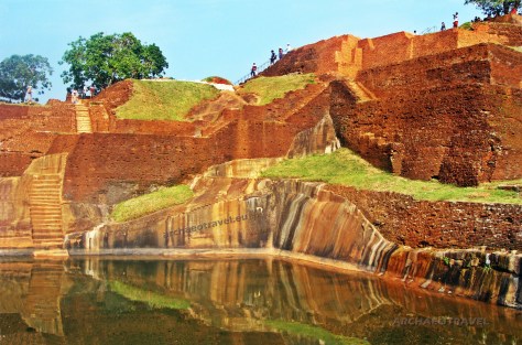
When I reached the flattened top of the one hundred and eighty metres high monolith of Sigiriya, I was supposed to see the remnants of a palace, which according to an official history was built on the rock on behalf of a fugitive King Kashyapa (Kassapa), at the very end of the fifth century AD. (473 – 495 AD.) (see: Kovalov 11th March, 2013; Mohan 2019). Instead, I saw there much more than I expected but the ruins of any palace; most striking of all were red-ramped ledges of bricks, towering from the upper corner of the top level over multiple terraces, marble and granite flights of stairs and a huge pool, filled with water intensively reflecting the sunlight (see: Kovalov 11th March, 2013; 14th March, 2013; Mohan 2019).
Despite my all efforts, however, I was unable to find there any single construction that I could interpret as a part of a palace (see: Kovalov 11th March, 2013; 14th March, 2013; Mohan 2019). Moreover, as much as I had observed examples of ancient south-eastern architecture elsewhere, contemporary secular constructions, even those belonging to kings and his entourage, all were usually made entirely or partially of wood and so they were likely to perish much earlier than any other structures made of stone or brick (see: Royal Terraces without a Palace of the Kings). The latter group was of a greater importance as such buildings were commonly dedicated to gods.
For example, a later royal palace of Sri Lanka, in Polonnaruwa, which was built in the twelfth century AD., features mostly the remains of bricked columns and vertical thick walls with holes, served for holding now perished wooden beams, having supported once higher level floors (Wulff Hauglann 2020; see: ). Similar characteristics are absent in the construction of Sigiriya, which successive ramps were entirely built of bricks, with some visible elements carved in stone.
Moreover, providing that the King Kashyapa’s life was at risk, he would not possibly have invested in a luxurious royal residence, engaging as much as cost as workload to erect a magnificent structure of bricks and stone on top of the rock, providing that it was supposed to be completed over hardly eighteen years.
Telling differences between a palace and a pyramid
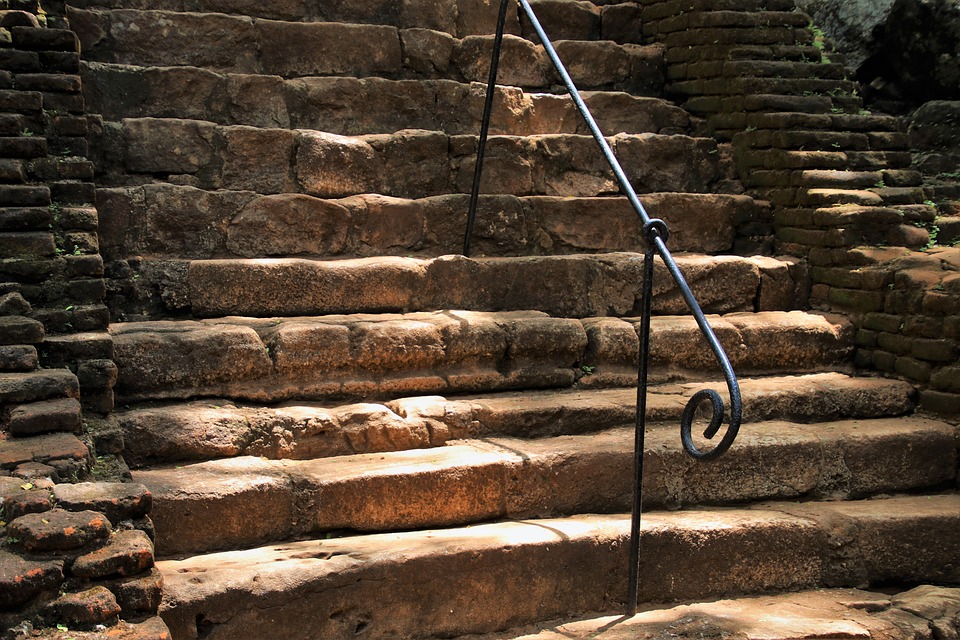
The ramped construction on top of the rock have got four sides and is built of red bricks with the use of the lime mortar between the bricks to bind them together (Mohan 2019). Its steps and ramps slope down from the north-western part of the top level of the rock southwards. Standing at the side of the granite pool, I observed red walls of the construction, successively climbing higher up, one after the other, similarly to stepped pyramids I had once seen in Mexico. As if against all of my guesses, having reached the flat platform on top of the ramped structure of brick, I eventually found a plate there, clearly reading “Palace” (see: Kovalov 11th March, 2013; 14th March, 2013; Mohan 2019). As a matter of fact, such plates are installed on all four sides of the ‘palace’ area, confirming that these are four sides of the palace; for example, one says: “West Palace”, and another, “South Palace”, standing for the western and southern parts of the area, respectively (Mohan 2019). The one even reads: “Palace Reception Hall” (Ibid.). And in general, archaeologists and historians claim the ruins as remnants of a palace but many alternative researchers, like Praveen Moha (2019) and Volodymyr Kovalov (2013), openly regard such a statement as misleading information as it is not based on any reliable source, especially when the so-called ‘palace’ is thoroughly examined on site.
A breathtaking view from the rock of Sigiriya with the bricked ramps of the pyramidal construction on top of it. Photo by Bodensee/Schweiz (2017). In: “pasja1000”. Photo source: Free images at Pixabay.
Firstly, its dimensions are ridiculously small; the size of the top pyramid platform is 17 metres in length and 11 meters in width, which means the ‘palace’ only had 187 square metres (Kovalov 11th March, 2013; 14th March, 2013; see Mohan 2019). Today, the whole structure would be barely sufficient for a medium-sized house, and it is simple to conclude that the space thought to be once a palace is simply not sufficient to be a residence of a king (Mohan 2019; see: Kovalov 11th March, 2013; 14th March, 2013). Comparing such measurements to the mentioned Royal Palace of Polonnaruwa, which are 31 metres by 13 metres (403 square metres), it is visible that the difference in size between these two edifices is striking (Wulff Hauglann 2020). Obviously, it may be explained by the fact the Palace in Polonnaruwa is a later building and it was not limited by space of the flattened surface on top of the Sigiriya Rock. However, a king and his entourage would have needed such a space for living, providing that there was enough room for arranging luxurious gardens, pools and pained walls with frescoes …
Taking into consideration that it was meant to be just a ‘miniature residence’ for a king, where is then a space for the king’s family and servants’ living quarters, for a harem, storage facilities or cooking areas? (Mohan 2019; Kovalov 14th March, 2013). Where was accommodation of the king’s entourage, such as his soldiers, guards, ministers or priests? (Mohan 2019). Adding to that, the summit of a huge rock completely does not fit any residential purposes; it is striking that despite the limited area for a palace itself, the area was also partially dedicated to other constructions, such as a huge granite pool and terraces and a garden stone bench, as if the King had rather been more interested in reclining than having a comfortable residence (Mohan 2019; Kovalov 11th March, 2013; 14th March, 2013). And even though some think that Kashyapa built a palace on the very summit of the rock to protect himself against his enemies, such a theory does not make any sense when one examines a historical fact of the King eventually having descended the rock to fight against his enemies on the ground (see: In the Realm of Demon Ravana).
Furthermore, providing that the builders of Sigiriya also created an elaborate line of defence systems, which was stretching for kilometres on the way leading to the very top, so preventing uninvited guests from reaching the structure, there was no need to build all such systems, using water and boulders, to only protect a cramped palace on top (Mohan 2019). Basing on the above, it can be assumed that the structure on the rock was built for a completely different purpose from the one usually suggested (Mohan 2019; Kovalov 11th March, 2013; 14th March, 2013).
‘Palace’ turns into a pyramid
If one rejects the official version, however, then the bricked construction on top of the Sigiriya rock simply changes from a palace into a ramped pyramidal structure. It is also worth mentioning that the pyramid on top of Sigiriya would not be the only one existing on the island (see: Mohan 2019).
Looking at the four sides of the ‘palace’ with its corners and edges at angle, it must be agreed that it could not have been a rectangular construction, like in the case of a typical stronghold, but more likely a stepped-pyramidal structure; whereas the walls of most regular buildings would be erected at 90 degrees to the ground, in the case of the structure of Sigiriya, there is a broad base and consecutive levels or steps getting smaller at slope angle from all the four sides towards the top, which is flat as today the pyramid is possibly missing the upper part (Mohan 2019). Nevertheless, the entire structure still consists of several plain levels and there are numerous flights of stairs to climb it (Ibid.). Staircases are mostly situated on the pyramid’s sides but some also appear running up in the middle of the platforms.
Secret of Sigiriya Staircases
What is quite surprising is that the staircases differ in their colour from the rest of the construction. This is because they are not made of red bricks, like the walls of the pyramid, but of white marble, adding that the staircases further down and surrounding the pool are entirely carved out of huge blocks of granite (Kovalov 11th March, 2013; 14th March, 2013). The two kind of stairs were originally installed there in ancient times and the stairs made of marble also appear among various constructions on the ground level (Kovalov 11th March, 2013; 14th March, 2013). Those from the top and the bottom levels are of the same size, shape and condition (Kovalov 11th March, 2013). The latter element furthermore brings other questions.
Namely, the state of the marble stairs is actually not good at all as their surface seems highly corroded (Ibid.). After Volodymyr Kovalov (11th March, 2013), this feature is highly surprising as there could not have been any damages caused to the marble by frosts in Sri Lanka. Moreover, assuming the official dating of the site to the fifth century AD., the condition of the marble stairs in Sigiriya is much worse than those from the same time but carved and installed in ancient Greece (Ibid.). I would even say that the marble stairs of the Athenian Acropolis are less worn out than those in Sigiriya, even though they are supposedly five hundred years older! So to say, the slabs of white marble used in Sigiriya must be more ancient than one thousand and five hundred years old (Ibid.). Such an assumption consequently questions the real age of the constructions of Sigiriya rock (Kovalov 11th March, 2013; 14th March, 2013).
Crawling snake on the flat top of the pyramid
Observing the top of Sigiriya from the flat top of the pyramid, one can get an impression that the successive steps of the pyramid together with the flights of stairs create a cascade flowing from the upper-left corner down, towards the pool. Unfortunately, the major portion of the pyramid was destroyed for unknown reasons so it is not possible to find out how it once really looked like (Mohan 2019). Praveen Mohan (2019) assumes the structure is today deprived of its final peak and it ends with a remaining flat top level surrounded by a ground alignment of the bricks. The latter seem especially interesting. Namely, the bricks incorporated there are not arranged in a straight line, as is usually seen in constructions around, but they are laid with curves, resembling more a snake’s body than a fence wall (Ibid.).
Was it a recreational garden?
Although, it is difficult to surely determine a purpose of all the baffling constructions that once existed in Sigiriya, one thing is sure; it was a very unique structure and all its parts had been built on site for some specific reasons (Mohan 2019). Apart from the said palace ruins, which are dominant on top of the rock, the other mentioned above constructions are believed to have been once a part of a recreational garden as they seem similar to those visible at the foot of the rock (Mohan 2019; Kovalov 11th March, 2013; 14th March, 2013).
Apart from successive levels of terraces, similar to those on the ground level of the complex, the large granite pool filled with water and multiple granite staircases around it, there is also the so-called ‘throne’, equally carved out of granite block (Kovalov 14th March, 2013). Such ‘thrones’ can also be encountered on the way from the ground level up to the rock peak (Kovalov 11th March, 2013; 14th March, 2013). All of them show a similar shape and the same high-quality of processing the granite stone (Kovalov 14th March, 2013). Nevertheless, they were not likely to serve as ‘thrones’ as there has never been enough space in front of it to bow in front of any king (Ibid.). After Volodymyr Kovalov (14th March, 2013), such structures rather resemble garden benches to sit down on and relax among walled terraces. Not to mention the fact they were perfectly carved out of one of the hardest stones present on earth.
Questioning the age of the site
The age of constructions encrusting Sigiriya is uniquely determined by the Culavamsa Chronicles, which covers the period from the fourth century AD. to 1815 (“Cūḷavaṃsa” 2021; see: Kovalov 11th March). The records cannot be, however, entirely reliable as they were written and compiled by various authors at different times (“Cūḷavaṃsa” 2021; see: Kovalov 11th March). Apart from that source, there is no other evidence of dating the buildings of Sigiriya (Kovalov 11th March). Furthermore, constructing such a highly advanced building wonder over a short period of several years by means of slaves who would have used contemporary tools seem quite unrealistic as much as applying hi-tech machines in ancient times may seem fabulous to others (Kovalov 14th March, 2013).
After alternative hypothesis, put forward by such a researcher as Volodymyr Kovalov (2013), the structures of Sigiriya could have been built in different phases, which followed one another in different times. Undeniably, the whole complex truly looks like a mosaics composed of various elements in terms of used materials and applied technology. Hence differences in textures and colours between various parts of multiple constructions around the monolith. According to such a hypothesis, Sigiriya’s buildings may be divided into different layers, corresponding to their age (Kovalov 14th March, 2013). Surprisingly enough, the elements that are unquestionably a result of a highly advanced technology apparently belong to the most ancient layer; they are all entirely carved out of granite blocks, like the pool surrounded by leading to nowhere granite staircases, polygonal megalithic stones and the so-called ‘throne’ (Ibid.). Such remnants are a part of a different story that may have happened thousands of years ago, possibly at the times when gods and demons, like Ravana, owned the island (Ibid.). This is why some visitors to the site, including myself, may have had an impression that such elements simply do not match or have been misplaced among the others. Other structures at Sigiriya are perceived as more recent (Ibid.). These are marble paths and flights of stairs, successively overbuilt in time with additional elements of bricks, which were erected either in order to create or just restore an already existing pyramidal structure from the past (Ibid.).
Finally, maybe some centuries later, the King Kashyapa committed a crime and was forced to move with his followers from the traditional Sinhalese capital of Anuradhapura to the more secured location (“Kashyapa I of Anuradhapura” 2021). Consequently, the king used the existing complex of Sigiriya as his refuge (see: Kovalov 14th March, 2013). Possibly he was even pushed to enter the forbidden and holy land of the lost gods and their heritage, in order to save his life. In such a way, all the constructions having been possibly built and overbuilt at Sigiriya for ages were eventually ascribed to the fugitive King, and so the previous Ravana’s court became his home for the following eighteen years.
Engineer’s thoughts over Sigiriya
For a while I discussed with an engineer from Poland I had met on top of the ‘pyramid’. He admitted to me he had got simply amazed with all the structures at Sigiriya, and especially he was curious about the way all the granite elements were processed on site without using any machinery. Crouching by the granite pool, he also showed me how the shaped blocks of granite and tool marks on them seem to harmoniously play with the natural structure and surface of the stone (see: Kovalov 11th March, 2013). ‘An application of such a technology is visible on site everywhere you go’, the engineer said.
‘But it is unknown to myself even though I’ve got much experience in processing stone for years … Actually, I have already seen it also on other sites around the island and elsewhere in the world’, he added. ‘ … These stone structures are just screaming with an advanced technology. The case is that nobody cares these days … Well, people are on holidays …’, he sighed.
Finally, he stood up and looked at the red ramps of the pyramidal structure growing above the flattened top level of the rock.
‘What about archaeologists …? What do they think about it all’, he asked, shifting his attention to myself.
I just smiled to him. There was nothing to add. Multiple questions stayed unanswered.
Featured image:The naturally made monolith of Sigiriya became home to mysterious ruins of stone and bricks, encrusting the rock and its surroundings. Photo by Anastasia (2016). In: “MadebyNastia”. Photo source: Free images at Pixabay.
By Joanna Faculties of English Philology, History of Art and Archaeology. University of Silesia in Katowice, Poland; Cardinal Stefan Wyszyński University in Warsaw, Poland; University College Dublin, Ireland.
BIBLIOGRAPHY:
“Cūḷavaṃsa” (2021). In: Wikipedia. The Free Encyclopedia. Available at <https://bit.ly/2U0XNdI>. [Accessed on 7th August, 2021].
“Kashyapa I of Anuradhapura” (2021). In: Wikipedia. The Free Encyclopedia. Available at <https://bit.ly/37MD4gQ>. [Accessed on 14th August, 2021].
“Sigiriya” (2021). In: Wikipedia. The Free Encyclopedia. Available at <https://bit.ly/3lG6y8n>. [Accessed on 7th August, 2021].
Free images at Pixabay. Available at <https://bit.ly/3fTQX0u >. [Accessed on 28th May, 2021].
Kovalov V. (11th March, 2013). “Chapter 1 of a Detailed Photo Essay on Sigiriya, or Lion’s Rock in Sri Lanka: Thoughts and Impressions of my Visit”. In: Vladimir KovalSky. Available at <https://bit.ly/37Unmht>. [Accessed 8th August, 2021].
Kovalov V. (14th March, 2013). “Chapter 2 of a Detailed Photo Essay on Sigiriya, or Lion’s Rock, in Sri Lanka: Thoughts and Impressions of My Visit”. In: Vladimir KovalSky. Available at <https://bit.ly/37p3Mw9>. [Accessed 8th August, 2021].
Kovalov V. (3rd June, 2013). “New mysterious riddles of Sri Lanka. What unites the ancient civilization of the Indian subcontinent with Africa, Atlantis and South America?”. In: Vladimir KovalSky. Available at <https://bit.ly/2ViKaF1>. [Accessed 7th August, 2021].
Mohan P. (2019). “Secret Pyramids Discovered in Sigiriya, Sri Lanka?”. In: PraveenMohan Youtube Channel. Available at <https://bit.ly/3CtIFH1>. [Accessed on 7th August, 2021].
Wulff Hauglann M. (2020). “10 Must-See Things in The Ancient City Polonnaruwa”. In: Nerd Nomads. Available at <https://bit.ly/3sEmyJN>. [Accessed on 22nd August, 2021].
Although the Google Map showed an estimated time of reaching the hill of Acropolis in thirty minutes, my uncle and I did not take into account the heat, generously sent by Helios, and the fact that we should first climb the path leading up to the hill (see: Island of the Sun in Favour of the Gods). At some point, we had to slow down our walk as the hillside grew steeper and so we were both out of breath (Lawrence 2005:Scroll XX). And even if we kept moving up, the site seemed still far in the distance. Why is it always so hard to see the summit while you are climbing up?
On the way up the hill
Located on the western edge of the city of Rhodes, the hill with the Acropolis on its eastern slope is called Agios Stephanos, also known as Monte San Stephano by the Italians (Hellenic Ministry of Culture 2010-2019; Via Gallica 2020). But there is also its third name, Monte Smith, after the name of the British Admiral, Sir Sidney Smith who built there in 1802 (Ibid.) “an observation post to monitor the movements of Napoleon’s fleet during the Egyptian campaign” (Via Gallica 2020). “[The] Acropolis of Rhodes and its imposing Temple of Apollo, dominates the views” (Hellenic Ministry of Culture 2010-2019).
The Acropolis of Rhodes on Agios Stephanos, also known as Monte Smith.Video source: Tourism Rhodes (2015) “Acropolis of Rhodes”. In: Tourism Rhodes Youtube Channel.
From the site, which is situated at altitude of 111 metres, it is possible to see a small valley surrounding the city and the western coast with precipitous cliffs overlooking blue waters of the Ixia Bay (Rice 1995:384; Via Gallica 2020; Themis 2020). Especially at sunset, the site “offers breathtaking [and panoramic] views [reaching as far as] the island of Symi and […] the Turkish coast, about [twenty] kilometres away” (Via Gallica 2020).
Two acropolises instead of one
As recent excavations have revealed, the ancient city of Rhodes had in fact two acropolises; the other one with the Temples of Aphrodite and Dionysus was situated on the site now occupied by the Palace of the Knights and Collachium (the northernmost part of the Medieval City) (Via Gallica 2020; Medieval Town “Collchium” 2019).
The ancient city of the Classical Greece was therefore much larger; “it stretched from the northern tip of the island at the site of the current” (Via Gallica 2020) Medieval Town and went south-westwards to where today are the remains of the Acropolis of Rhodes (Ibid.). The latter “was a large elevated plateau […], lying just inside the main fortification wall, running [east-west], along the southern boundary of the [ancient] city” (Rice 1995:384). Unlike most ancient acropolis, that one was not fortified (Hellenic Ministry of Culture 2010-2019; Via Gallica 2020); so “it is not a towering citadel which dominates the lower city, but it does present a distinct elevated profile when Rhodes is seen from the sea – the means of approach in antiquity. [Ancient] streets running [westwards and southwards] from the main inhabited areas in the [east] and [north] gave access to the [Acropolis] from the [city], and it could also be reached from outside […], through the city gate situated near the southern end of modern Odos Sophouli (ancient north-south street P)” (Rice 1995:384).
Nowadays, it is possible to get there from the Medieval Town either by bus or on foot, leaving through the western side of the city walls (Via Gallica 2020).
Lecture on Greek architecture
The Acropolis finally opened to us, revealing its treasures. “Far from the urban liveliness, [we were] standing on the top of Monte Smith hill” (Themis 2020), accompanied just by striking musical performances of Greek cicadas. I felt utterly tired but deeply satisfied we made it. My uncle even speeded up while we are approaching a row of reconstructed columns towering ahead as if the city’s guardian (Tourist Guide 2020). They are the part of the Temple of Apollo Pythios, “which are visible today from the commercial harbour even above the intervening modern building” (Rice 1995:384). they. ‘Amazing’, my uncle admitted, still panting. ‘Now I can give you a lecture if you want’, he exclaimed enthusiastically, gasping for breath.
It must be emphasized that many areas [of the site] are now overgrown or filled in since they were last investigated many decades ago, which makes any observations based only on what is visible to the naked eye today superficial and in need of refinement” (Rice 1995:387). But in its glorious past, the site must have looked impressing; “it consisted of a monumental zone with [sanctuaries], large temples, public buildings and places of worship, [including underground cult places] (Hellenic Ministry of Culture 2010-2019]. Significant buildings] were mainly built on terraces reinforced by powerful walls” (Via Gallica 2020).
Different constructions vary in their dating but most buildings were erected during the Hellenistic times (323-31 BC) (Stefanu 2017; Via Gallica 2020). “These public structures would have been a visual highlight above the busy harbours, drawing the eyes above and away from the bustling dock areas” (Rice 1995:348). Apart from the Temple of Apollo (C), on the Acropolis stood the Temple of Athena Polias and Zeus Polies (B) (Ibid.:384). There was also “the stadium (D) with an adjacent [Odeion] (E), very probably a nearby gymnasium (F) and possibly the theatre (G)” (Ibid.:384). The lecturer in classical archaeology, E. E. Rice (1995:384) says that “it […] appears likely that the main civic sanctuary of Helios […] was located on the eastern [side] of the [Acropolis of Rhodes]”.
In the third century BC., it may have housed one of the legendary Wonders of the Ancient World and Greece, the bronze statue of the Colossus of Rhodes, (Ibid.:384). From that point, the mounting representation of the patron Sun god, Helios, would be visible to those approaching the island from the sea.
On the Rhodian Acropolis, there were possibly also landscaping features, characteristic of ancient sanctuaries, such as trees and sacred groves surrounding the buildings (Ibid.:386). Such a theory is attested by the observation made by the orator Aelius Aristides, from the second century AD, (Ibid.:386) “that ‘the Acropolis is full of fields and groves’. […] The open spaces of the Rhodian [Acropolis were probably] due to the fact it was a virgin site when the city of Rhodes was founded and designed at the end of the fifth century BC. […] The new structures which were built upon the [Acropolis] were therefore inserted into the natural landscape which already predominated; [these were] fields, groves, natural rock hollows [and] cliff faces […]” (Ibid.:386).
Stadium and Odeion
In an olive grove to the east of the Acropolis, there are the partly restored Temple of Apollo, the stadium and the Odeion (Via Gallica 2020). The so-called stadium of Diagoras was built around second century BC. (Themis 2020; Via Gallica 2020).
It is located southeast of the hill and oriented north-south (Hellenic Ministry of Culture 2010-2019). It measured according to the Greek standards, over one hundred and eighty metres in length and around thirty-five in width (Via Gallica 2020). This was one of the very first sites that were excavated in 1912 and, like the Odeion, it is was largely restored (Stefanu 2017; Via Gallica 2020). Hence their perfect condition known at present (Ibid.). The stadium could contain over ten thousand spectators, attending various exhibitions and athletic games (Stefanu 2017). There “athletic competitions were staged as part of the Haleion Games, an important celebration held by the ancient Rhodians in honour of the god Helios” (Hellenic Ministry of Culture 2010-2019).
However, taking into account that the uppermost part of the monument has not been excavated yet, its size and so the capacity of the stadium may have been much larger (Stefanu 2017). Among the stadium’s authentic parts, there are sphendone (a semi-circular part at the end of an ancient Greek stadium), the proedries (seats of honour, dedicated to the officials), (Hellenic Ministry of Culture 2010-2019), “and some of the lower seats in the auditorium. Also preserved is the starting mechanism for the athletes” (Ibid.). The stadium was made from the local limestone, with rectangular blocks but of different sizes, which depended on their location (Stefanu 2017). Each element has got smooth surface and fits perfectly in the whole construction without the use of mortar (Ibid.). To the east of the stadium, there was additionally a gymnasium, which was partially uncovered (the western side along with its north-east corner) (Via Gallica 2020). It was a large square building (around two hundred metres wide), where many works of art were uncovered (Ibid.).
Another important element of the ancient site lies northwest of the stadium (Via Gallica 2020). It is a white marble Odeion (theater) built in the second century BC (Stefanu 2017; Via Gallica 2020). It was possibly used for attending musical performances or rhetoric lessons given by famous speakers, as its stage is too small to be a scene of a theater (Ibid.). One who was standing in the middle of it could be well heard around, at each point of the construction (Stefanu 2017). There were probably eight hundred spectators who could watch performances (Via Gallica 2020). Although the Odeion looks impressive today, it has been entirely rebuilt by the Italian archaeologists, and only its bottom shelf is authentic (Ibid.).
Today tourists usually enjoy the sunset sitting on the stairs of the stadium or of the nearby Odeion, which regularly hosts musical and theatrical performances (Themis 2020). At the time of our visit, however, there were just a few tourists walking around the reconstructed columns; it was definitely too hot to enjoy the Acropolis by staying for longer in the sun. Our sightseeing unfortunately fell at full noon, but we had no choice due to limited time on Rhodes. If we had stayed on the island a few days, we would have certainly taken the evening walk to the Acropolis with the family, of course, just for volunteers …
Agora and necropolis
The both constructions, the stadium and Odeion, were once situated just in the centre of the ancient agora (known as the forum in the Roman times) (Stefanu 2017). It was a very central site, where all the political and cultural events took place (Ibid.). Piles of ancient stones placed together there consist of finds from the archaeological excavations; they all come from the ancient agora and contain precious parts of various buildings, sometimes covered in Greek writings (Ibid.). It is a pity, they are not exposed in the museum as objects of further studies (Ibid.).
South of the ancient city, there is also a Hellenistic necropolis of Saint John (Agiou Ioannou) (Tourist Guide 2020; Via Gallica 2020). “The most important of these are the large corner funerary complex with tombs featuring vaulted masonry tombs, the cluster of yet more tombs of vaulted stonework crowned by a monument with triglyphs and metopes and the tomb carved into the rock that includes a monumental gateway. Of greatest interest is the underground quarry where burial chambers were dug into the sides of the tunnels”(Tourist Guide 2020).
Stairs leading to the temples
Nonetheless, the most significant part of Monte Smith is the Acropolis (Stefanu 2017). From the place of the previous agora, there are stairs leading up to the Greek temples of Acropolis of Rhodes, which were, like other ancient sanctuaries, built upon an area of elevated ground (Stefanu 2017; “Acropolis” 2020). Hence akron, meaning the highest point and polis – city (“Acropolis” 2020). Today, on the site, there are mostly huge pieces of stones, such as blocks of local limestone and marble, possibly from Naxos or from Pharos, scattered everywhere around the place (Stefanu 2017). Some original building material had already disappeared; they were mostly reused for the construction of post-Hellenistic buildings (Ibid.).
“[Once] situated on the northern edge of the Acropolis, the Temple of Athena Polias and Zeus Polies was orientated east-west and was a porosDoric peripteral temple (having a columned portico on all four sides). Four oversize column drums and parts of a capital and architrave still [can] be seen on the site. This was where the Rhodians kept the texts of their treaties with other states.
The temple stood in a larger temenos bounded by a stoa on the east” (Hellenic Ministry of Culture 2010-2019). The only reconstructed structures, however, belong to the Temple of Apollo, which was also built in the Doric style (Via Gallica 2020). The temple stood “on the southern part of the hill, on the west side of a large rectangular terrace. It [was] orientated [east-west, and like the Temple of Athena Polias and Zeus Polies it was also a poros peripteral temple, but smaller […]. Part of [its north-eastern] side [has been restored” (Hellenic Ministry of Culture 2010-2019): rising from the incomplete stylobate, there are just four columns and a small section of the entablature as the remains of the temple colonnade. It is also evident that its entrance must have once led through a wide staircase (Via Gallica 2020). Although the temple does not exist anymore, the preserved remains are still able to witness to its monumental character (Ibid.).
Nymphaea
Nothing was left from the once impressive façade of the stoa (a covered walkway or portico for public use); only its foundation has been preserved to our times (Via Gallica 2020; “Stoa” 2020). Southeast of the stoa wall, there starts “the first of a series of elaborate rock-cut chambers [carved in] the slopes beneath the [Acropolis] summit; other similar [underground] systems are [cut] into the ridge that curves to the [south and west], towards the main buildings on the summit, and to the [north] where it meets the [western] edge of the [Acropolis]. These structures, partly open to the sky but beneath ground level, have traditionally been described as nymphaea” (Rice 1995:387-388) or the Temple of Nymphaea (Via Gallica 2020).
“The word nymphaeum originally meant a shrine of the nymphs, but since nymphs were traditionally associated with caves, and caves with water, the term came to be [later] applied to an ornamental fountain” (Ibid.:388). Archaeological study shows that the Temple of Nymphaea on the Acropolis of Rhodes “consists of four subterranean cave-like constructions cut into the rock with entrance steps, communicating passages and a large opening in the central part of the roof. […] Water cisterns and lush vegetation complete the picture” (Hellenic Ministry of Culture 2010-2019) “Despite the undoubted fact that shade, water and attractive decoration would have made these places pleasant enough to visit and linger in during an ascent to the [Acropolis], they nonetheless led directly to the summit where the main religious buildings were located. The alignment with the grid plan and direct connections with streets and stoas make this evident” (Rice 1995:403).
Why were such underground structures built? What function might they have had? It is believed “they were places for recreation and worship” (Hellenic Ministry of Culture 2010-2019). “Cults of the nymphs were [highly] popular [in the Hellenistic] period; they and Pan were also worshiped in Rhodes. [A late] fragmentary inscription found on the Rhodian [Acropolis], dated to the third or fourth century AD, […] mentions a shrine of Pan (a ‘Paneion’) near of sanctuary of Artemis Thermia, [the goddess who was Apollo’s twin sister]” (Rice 1995:402). Nothing else is known about the Paneion but there are the remains of other places of worship, which may have once been the Artemision (a temple attributed to the cult of Artemis) (Rice 1995:402; Hellenic Ministry of Culture 2010-2019).
The cult ‘Thermia’ of the goddess Artemis presumably had associations with thermal waters. It can be hence speculated that ‘some grottoes indeed had passages which connected into the underground aqueduct system” (Rice 1995:402-403). If so, the artificial caves would have “played an important role, since water supply was vital to the survival of the city, and they might have functioned as shrines to deities directly associated with water, [which is manifested by] recesses in the interior walls for statuettes” (Ibid.:403). “[The] evidence of the votive dedications [in the caves] shows that these areas clearly had a primarily […] religious function. The extensive systems of grottoes covered a significant part of the Rhodian [Acropolis, including] the separate system of [south] of the [Temple] of Apollo precinct” (Ibid.:403), and so it may have once been linked to the temples themselves. It is hoped that future archaeological excavations by modern methods may go some way [further] in revealing its mystery (Ibid.:402).
Successive ways of destructions
All the ancient acropolises on Rhodes and elsewhere are located on the mounts, as much as the sites falling on the axis dedicated to both, Apollo and Saint Michael (Broadhurst, Miller, Shanley, Russel 2000-2003). The following conquerors of Rhodes also reached there but did not respect the ancient sites and they left their signs on them as the remnants of war, having scratched the beauty of the temples (FM Records 2014). Who and why destroyed them?
As a matter of fact, there were three periods that had greatly contributed to the destruction of the site (Stefanu 2017). The first devastation was, however, caused by nature and happened already in 226 BC, when a huge earthquake hit the island of Rhodes and toppled down most of the buildings on the site, including the Colossus of Rhodes (Ibid.). The temples of the Rhodian Acropolis were rebuilt but in 42 BC they were again destroyed (Ibid.). This time it was because of the Roman senator, Casius, and his army (Ibid.). Yet, the most modern warfare turned out to be the most destructive to the Acropolis (Ibid.). In 1944, the Germans installed their artillery on the hill, which was consequently bombarded by the British (Ibid.). That it turn affected the temples, which suffered considerable damage (Ibid.).
Time for excavations
Successive excavations and restoration work carried out on Rhodes in the twentieth century allowed to uncover the sites and reconstruct some of the ancient buildings. However, historically diverse, multiply layers of uninterrupted constructions makes such sites difficult to excavate and interpret archaeologically (“Lindos 2020”).
“The [Acropolis] of Rhodes offers different archaeological problems from those posed by the rest of the ancient city. Unlike the lower town, the hill has not been much built over, but neither has it been much excavated except for the Temple of Apollo Pythios and the stadium-Odeion area, which [had mainly been] investigated and reconstructed” (Rice 1995:387) by the Italian School of Archaeology in Athens from 1912 to 1945 (Via Gallica 2020). Other areas have been partially studied both by the Italians and by the Greek Archaeological Service after the World War II (Rice 1995:387).
“From 1946 onwards Greek Archaeologists [have conducted] a series of excavations, bringing into light important findings regarding the site’s history and topography. During the 60’s and 70’s more reconstruction work was carried out to the west foundation of the Temple of Pythian Apollo. In 1996 further reconstruction was added on the Temple and the [Nymphaeum]. There is still an ongoing excavation in the Acropolis archaeological park, a protected area that covers an area of 12,500 m². As the archaeologists say, the current findings represent only a fragment of the glorious past of the ancient city of Rhodes” Hellenic Ministry of Culture (2010-2019).
Back to the port
Suddenly, my uncle awoke from thoughts on the ruined temples and quickly looked at his watch. He looked terrified. ‘She’s going to kill us’, he said. I knew who he meant.
Around thirty minutes later, we were back at the port of Rhodes. We had made our way back much faster as, according to the basics of the physics and fear, we were walking down, additionally being pushed by the vision of my furious aunt. Meantime, we got a message that the whole company was waiting for us in a cove with a small beach, just outside the Old Town walls at Virgin Mary’s Gate. The place is located between Kolona Port and Cruise Port, so we could wait in the proximity for our ferry to go back to Asia (Rhodes Oldtown 2020).
When we got there, again breathless, everybody was either enjoying sun or swimming in the warm sea. My aunt did not even notice at first we came back. She just waved to us from water. After a while, I reminded myself that I was still wearing my bikini underneath, and soon I also dived into blue sea. It was a great refreshment after the archaeological adventure full of sun and effort.
The island’s ambiance took me centuries back (FM Records 2014). It seemed as if the Sun god had shed beauty to his land; on Rhodes, visitors got the impression of living in a fairy tale as they are carried away by the blue sea, warm beaches, locals’ welcoming smiles, picturesque ports, churches, and soaring ancient temples (Ibid.).
By Joanna Faculties of English Philology, History of Art and Archaeology. University of Silesia in Katowice, Poland; Cardinal Stefan Wyszyński University in Warsaw, Poland; University College Dublin, Ireland.
BIBLIOGRAPHY:
“Acropolis” (2020). Wikipedia, the Free Encyclopedia. Available at <https://bit.ly/2YTKwBZ>. [Accessed on 19th June, 2020].
“Acropolis of Rhodes” (2020). In: Wikipedia. The Free Encyclopedia. Available at <https://bit.ly/3g9dY1b>. [Accessed on 19th June, 2020].
“Rhodes (city)” (2020). Wikipedia, the Free Encyclopedia. Available at <https://bit.ly/3tiovei>. [Accessed on 19th June, 2020].
“Stoa” (2020). In: Wikipedia. The Free Encyclopedia. Available at <https://bit.ly/3urJqMz>. [Accessed on 19th June, 2020].
Broadhurst P., Miller H. Shanley V., Russel B. (2000-2003). The Dance of the Dragon. An Odyssey into Earth Energies and Ancient Religion. Launceston: Mythos.
FM Records (2014). “Discover Greece – (Rhodes, Kos, Leros, Samos, Chios, Patmos)”. In: FM Records. Available at <https://bit.ly/2V0AgXz>. [Accessed on 19th June, 2020].
Hellenic Ministry of Culture (2010-2019). “The Acropolis of Rhodes”. In: Discover Rhodes. Available at <https://bit.ly/3ehq198>. [Accessed on 18th June, 2020].
Kebric R. B. (2019). “The Colossus of Rhodes: Some Observations about Its Location”. In: Athens Journal of History, Vol. 5, Issue 2, pp. 83-114. Available as PDF at <https://bit.ly/3gbgWCy>. [Accessed on 20th June, 2020].
Lawrence C. (2005). The Roman Mysteries: Book 9: Colossus of Rhodes. Orion Children Books.
Medieval Town (2019). “Collchium”. In: Medieval Town Map. Discover Every Secret Corner. Available at <https://bit.ly/30VSvRS>. [Accessed on 19th June, 2020].
Photo: “Nymphaeum of Monte Smith (picture 40936781)” (2020). In: mapio.net. Available at <https://bit.ly/2CqbU3a>. [Accessed on 20th June, 2020].
Rhodes Oldtown (2020). “Best Beaches near Rhodes Old Town”. In: Rhodes OldTown.gr. Available at <https://bit.ly/30Y2CWo>. [Accessed on 19th June, 2020].
Rice E. E. (1995). “Grottoes on the Acropolis of Hellenistic Rhodes”. In: The Annual of the British School at Athens Vol. 90, Centenary Volume, pp. 383-404.
Stefanu V. (2017). “Greek island of Rhodes: Stunning ancient Acropolis, full tour, what to see!”. In: Amazing World Videos. Available at <https://bit.ly/2YgUmih>. [Accessed on 19th June, 2020].
Tango7174 (2011). “Rhodes Acropolis”. In: Wikimedia Commons. Available at <https://bit.ly/2YOzspU>. [Accessed on 20th June, 2020].
Themis (2020). “The Acropolis of Rhodes”. In: Themis Private Villa. Available at <https://bit.ly/2ANWHIJ>. [Accessed on 18th June, 2020].
Tourism Rhodes (2015). “Acropolis of Rhodes”. In: Tourism RhodesYoutube Channel. Available at <https://bit.ly/3egn20m>. [Accessed on 18th June, 2020].
Tourist Guide (2020). “Acropolis of Rhodes – Ancient Stadium”. In: Oikonomou N. Rhodes. Tourist Guide. Stavros Kirkos Publications. Available at <https://bit.ly/3fADCZi>. [Accessed on 18th June, 2020].
Via Gallica (2020). “The Ancient City of Rhodes”. In: Via Gallica. Available at <https://bit.ly/2NcPVyO>. [Accessed on 19th June, 2020].
Having entered the Mayan city of Palenque, I left a group of colleagues slightly behind to plunge into the labyrinth of the Palace complex. From there, the facade of the Temple of the Inscriptions kept proudly looking at me, while holding its mystery intact. For a moment, I was slowly walking among the jagged ruins, passing by their openings of strange shapes and of unknown functions, and, as if without a plan, I groped among the contradictory theories put forward on Palenque over the years by various researchers. On the other hand, the accumulation of such conflicting hypotheses forces a deeper reflection and a closer look at debatable structures and artifacts. Or maybe it is worth taking a general look at the Mayan culture and their city first and then going into details? But sultry Palenque still remains a mystery.
Outstanding rulers of Palenque and their city running out of food …?
The oldest traces of settlement in the area of Palenque are dated back to the third century AD., but most of the buildings and facade decorations go back to the Classic Period, the time when the city flourished between 600 and 800 AD. (Prager, Grube 2013:447; Von Däniken 1991:163).
K’inich Kan B’alam II, one of the many rulers of Palenque. Detail from the Temple XVII Tablet. Photo by Mdcarrasco – Own work (2007). Public domain. Photo and caption source: “Palenque, Chiapas” (2021). In: Wikipedia. The Free Encyclopedia.
It was then, under the rule of the most significant of the local rulers: K’inich Janaab Pakal, his son Kan Balam II (684-702) and K’an Joy Chitam (702-711) (Ibid.:447). This dynasty was interrupted by the capture of K’an Joy Chitam around 711 by the hostile city of Tonina, but its rule was continued by K’inch Ahkal Mo ‘Naab III (721-736), coming from the adjacent line of the family who eventually commissioned the construction of the Temple XIX (Ibid.:447).
While the city was certainly one of the main centres of the Maya people, this fact is quite surprising to some scholars, as Mark Van Stone, PhD. (Burns 2012). For in the jungle the soil that could be cultivated was unusually thin and so could not provide enough food with such a large urban centre (Ibid.). What makes it even more astonishing is that Palneque was one of the most populated cities of the Maya, even twenty times more than it is observed in the region today (Ibid.).
Complex sewage system
Ancient Palenque rises high above the plains of Usumacinta, at the foot of the Tumbalá Mountains, in the Mexican state of Chiapas (Hohmann-Vogrin 2013:202; Burns 2012; Von Däniken 1991:173). The ritual centre itself is situated on hills and artificial terraces, which perfectly fit into the natural terrain (Hohmann-Vogrin 2013:202). The terraces themselves are separated in turn by the Otolum stream into the western and eastern parts (Von Däniken 1991:173). Its natural bed was directed by an artificial and wide underground network, so that in some places the Otolum waters still flow through the city by means of vaulted canals (Hohmann-Vogrin 2013:202; Von Däniken 1991:173; Burns 2012).
Based on the research to date, it is also known that the inhabitants of Palenque additionally developed a complicated system of aqueducts, and obtained water pressure by leading the artificial channels from the main riverbed (David Hatcher Childress in: Burns 2012). In the past, this sophisticated sewage system also took over streams of rainwater flowing from the roofs of temples, then led through aqueducts and underground channels to the structure, known commonly as the Palace (Von Däniken 1991:173). For Erich von Däniken, who often followed in the footsteps of archaeologists by asking them a series of uncomfortable questions, the similar sewage system in Palenque is already a cause for amazement (Ibid.:173).
What experts claim
Mesoamerican culture experts believe that Mayan construction techniques primarily determined the need to drain water as quickly as possibly during heavy rainfall, especially in dense jungle areas, and the need to take appropriate steps to store it for later use (Hohmann-Vogrin 2013:200). Free-standing courtyards with houses on platforms, arranged at different levels and perhaps surrounded by gardens, were perfectly suited to these requirements (Ibid.:200). The water could flow in any direction and be stored in domestic cisterns or huge tanks (Ibid.:200). The same rule was applied in case of monumental buildings, such as palaces and temple architecture (Ibid.:200). Stucco-covered courtyards or large squares, and in some cases causeways, were probably designed to channel and store water (Ibid.:200).
Moreover, largely due to the tropical climate, very few enclosed and covered rooms were built in the area (Hohmann-Vogrin 2013:200). Most of the activities, public and private, could be performed outdoors or under a light roof (Ibid.:200). Therefore, it seems logical, as specialists claim, to focus on Mayan cities’ open spaces when analysing their complex architecture (Ibid.:200).
Successive excavations and discoveries
Although excavations in the city of Palenque began in the 1940s, the ruins of the city itself have still not been sufficiently explored (Prager, Grube 2013:447; Burns 2012). The archaeological site measures 1780 hectares, including nine major recorded areas with 1400 buildings (UNESCO 2021). On the whole, the archaeological research carried out so far covers around 10% of the whole area (UNESCO 2021; Prager, Grube 2013:447; Burns 2012). Moreover, due to the rainy season, excavation work is usually limited to four months of the year (Von Däniken 1991:179). Since so far the greatest discovery in Palenque, which was revealed in the Temple of the Inscriptions, another Temple of the city, labelled as the Temple XIII, has unveiled the tomb of the so-called Red Queen (1994) and a stone throne has also been discovered in the Temple XIX (1999) (Prager, Grube 2013:447). And there was yet uncovered another burial in the Temple XXI (2013) (Ibid.:447). Therefore, new important archaeological finds may hopefully come to light soon (Ibid.:447).
Wealth of architectural elements and details
A breath-taking architecture of the city, such as the so-called Temple of the Inscriptions, the Palace complex, the Ceremonial Courtyard, and several smaller temples and residential districts around it, all constitute the essential centre of Palenque (Prager, Grube 2013:447).
A bas-relief in the Palenque museum that depicts Upakal K’inich, the son of K’inich Ahkal Mo’ Naab III. Photo by Soerfm (2018). CC BY-SA 2.0. Photo and caption source: “Palenque, Chiapas” (2021). In: Wikipedia. The Free Encyclopedia.
All buildings in the city were once decorated with rich stucco reliefs and colourful wall paintings (Hohmann-Vogrin 2013:202). They even appear in the vaulted sections found at the rear of the edifices, which similarly to their facades and stair ramps, also contain the remains of beautiful stucco reliefs (Ibid.:203). In turn, inside the buildings, there have been preserved large and artistic wall reliefs, made of particularly fine-grained limestone (Ibid.:203). Like Mayan hieroglyphic inscriptions, such reliefs often refer to complex figural scenes (Ibid.:203). The so-called roof combs at gable ridges are typical of the Mayan architecture; also in Palenque, if preserved, these peculiar crests still crown the central part of the roof of the temples (Ibid.:203-204). Since the roof combs are filigree structures, they feature multiple openings, and so together with the temple they give a whole compact blocks of architectural pyramids a specific lightness (Ibid.:203-204). In the past, they were additionally decorated with colourful painted surfaces and stucco (Ibid.:203-204). Roof combs, which seem to have been intended for the gable ridges of more important sacred buildings, also gave the structures an impression of height and monumentality (Ibid.:199).
Temple of the Sun with an intricate roof comb. Photo by Éclusette – Own work (2009). CC BY 3.0. Photo source: “Temple of the Cross Complex” (2021). In: Wikipedia. The Free Encyclopedia.
Moreover, the door openings reached almost to the level where the corbelled vaults began and were topped with stone lintels or stone beams (Hohmann-Vogrin 2013:199). In turn, numerous vaults in Palenque reveal unusual leaf-shaped trefoil, and mysterious keyhole arches appear in the city’s niches, window openings and doorways (Ibid.:203). Did they serve merely as a decoration or did they evoke a symbolic meaning?
Significance of the keyhole
Window openings and arches in the form of a keyhole appear all over the city of Palenque, where they feature some buildings of the Palace complex and, particularly, the Temple of the Foliated Cross (Burns 2020).
Surprisingly, they do not occur in architecture of any other Mayan cities. A similar symbol had been, however, used in sacred and sepulchral architecture of many ancient cultures around the world (Ibid.). The keyhole form is, among all, observed in the shape of burial mounds in Japan and Algeria, geoglyphs in Saudi Arabia, sacral-astronomical structures in Peru, in the United States, on the Italian island of Sardinia and in India (Ibid.). Some of them are so huge that their shape can be recognized only from the bird’s eye view (Ibid.). As an Arabic legend goes, a similar symbol also adorned the so-called Seal of the biblical King Solomon, which served him as a tool for subjugating demons and so using them to build a Temple for the Ark of the Covenant (Ibid.).
Temple of the Foliated Cross with mysterious window openings in the form of a keyhole. Rob Young from United Kingdom – Temple of the Foliated Cross (2012). CC BY 2.0. “Temple of the Cross Complex” (2021). In: Wikipedia. The Free Encyclopedia.
In ancient Egypt, the so-called menat necklace was worn with a heavy pendant at the back, in the form of a keyhole, used as its counterbalance; it was mainly associated with the goddess Hathor, who was also called Meant, and with the Moon god, Chonsu, who was a guardian of the invisible worlds (Burns 2020; “Menat” 2020). “His name means ‘traveller’, and this may relate to the perceived nightly travel of the Moon across the sky” (“Khonsu” 2021). In ancient Egyptian iconography, the meant is often passed down by gods to members of the aristocracy (Burns 2020). What is even more intriguing, a similar symbol was an attribute of another lunar deity, the Phoenician goddess Tanit (Ibid.). Moreover, a mysterious well-like structure in the shape of a keyhole in Sardinia was also architecturally associated with the Moon; namely, its dome was apparently designed to observe the Moon at its highest stage, that it to say, at the moment of the so-called lunar standstill (Ibid.). A similar structure built in India also refers to the same astronomical phenomena, which is the lunar cycle that lasts eighteen years (Ibid.). For this reason, some researchers have suggested the keyhole symbol is associated with celestial bodies such as the Earth and the Moon, and therefore, with our planet’s relations with the sky (Ibid.). Did the keyhole openings in Palenque use to have a similar function?
An elaborate menat necklace depicted in a relief at the Temple of Hathor at Dendera, Egypt. Photo by Olaf Tausch – Own work (2011). CC BY 3.0. Photo and caption source: “Menat” (2020). In: Wikipedia. Wolna Encyklopedia.
Today, it is still a mystery why so many ancient cultures in different and distant corners of the world, including the Maya, used to illustrate such a symbol in their architecture or sacral objects (Burns 2020). Keys and locks have existed since ancient times, serving indirectly to open gates and doors (Ibid.). As such, the keyhole may have had a ritual significance in opening symbolic gates (Ibid.). But what did they open to? And what is the key to those gates, matching the keyhole? The origin of the symbol still remains a mystery, but whatever inspired its shape, it had to be quite significant to our ancestors (Ibid.).
Corbelled vault and its key functions
While major elements of Mayan architecture were relatively simple, they developed into quite rich and varied forms (Hohmann-Vogrin 2013:199). Between the Preclassic and Early Classic periods, there were observed some changes in building techniques; specialists note that the walls of contemporary Mayan buildings were built of more precisely cut stones, which made the layer of lime plaster applied to them much thinner (Ibid.:198). The use of a corbelled (cantilever) vault, the method used to build a roof using stones and mortar, had also increased at that time (Ibid.:199;. see: Mystery of the Casas de Piedra in Palenque).
In a corbelled vault, also referred to as a false vault, horizontal blocks of stone protrude further inwards in individual layers, getting closer to each other, and thus connect two supporting walls (Hohmann-Vogrin 2013:199). The vault was eventually closed by means of a flat stone slab (Ibid.:199).
Other solutions in vaulting the roof
In the Early Classic Period, most of the burial chambers in the deeper layers were cut off and closed with a corbelled vault (Hohmann-Vogrin 2013:199).
K’inich K’an B’alam II (“Chan Bahlam II”). Photo by Sergio~commonswiki (2006). Public domain. Photo and caption source: “Palenque, Chiapas” (2021). In: Wikipedia. The Free Encyclopedia.
False vaults had been widely used in many buildings from Late Classic centres, such as Palenque, although there were also vaults composed of rubble and ceilings with wooden beams covered with a layer of stucco (Hohmann-Vogrin 2013:199199). The latter were widespread in the Mayan lowlands in the Late Classic and Postclassic periods (Ibid.:199). They had the advantage of covering large room spaces (Ibid.:199). At the same time, they were quite unstable (Ibid.:199). In order to prevent water from penetrating into the building, especially in the rainy season, new layers of stucco had to be constantly applied (Ibid.:199). In turn, vaults made of rubble was a system, where the stones protruding from the wall structure in a false vault were replaced with a mixture of mortar and stone, in such a way that the vault stones visible from the below were nothing but a clever illusion (Ibid.:199).
More intricate constructions
The use of a corbelled vault allowed a construction of long houses with several entrances and two or three rows of vaulted rooms, placed one above the other, and providing the building with subsequent levels, to which the entrance led with separate stairs (Hohmann-Vogrin 2013:199).
The vaulted rooms were placed either alternately or one above the other (Hohmann-Vogrin 2013:199). The facades of buildings were clearly divided into a horizontal wall and a fragment filled with vaults, often with the base between the terrace level and the upper edge of the floor inside the building (Ibid.:199). These areas were usually separated by sills (Ibid.:199). An example of such a multi-storey complex in Palenque is the so-called Palace.
Analysis of the Mayan architectural functions within a city-state
An accessibility, location and connection system of Mayan building complexes within a given city state indicate whether the area was used for private or public functions (Hohmann-Vogrin 2013:200).
Religious ceremonies were believed to have been held in centrally located buildings, not easily accessible, but well recognizable (Hohmann-Vogrin 2013:200). Limited access to the complexes erected on elevations, most often on several levels, near large, open squares, proves that they were used as palaces, as much as it is present in Palenque, whose Palace is placed just in the center (Ibid.:200). “The plan [of the city itself] follows a pin-wheel arrangement, as well as a gridded system. [Already its early] explorers [had] noted stunning similarities in the design of [its] stone structures and their apparent use.” (Blankenbehler 2015).
Depending on the location within the whole city layout, separate areas were used for representative purposes or domestic functions (Ibid.:200). In many regions of the central lowlands, ball fields, which are most typical urban features of the Pre-Columbian cities, are usually located in front of the palace complex (Ibid.:200). This location is different in Palenque, where the remains of an area interpreted as a ball field are located in the northern part of the city complex. In turn, in the north of the lowlands, separate parts of buildings considered as Mayan palaces, such as residential, representative and administrative parts, were housed in distinct building complexes (Ibid.:200).
In Palenque, the said Palace complex was located in one single, though intricate complex, which would be indicative at once of its private, administrative and representative function. At the same time, along with the nearby temples erected on stepped pyramids, it would accordingly perform ceremonial functions.
El Palacio
The Palace of Palenque was discovered at the end of the eighteenth century by the Spanish (Burns 2012). It is one of the greatest Mayan structures of its kind and the largest architectural complex in Palenque at all (Ibid.). The palace complex is located in front of the Temple of the Inscriptions, just in the middle of the ancient city (Hohmann-Vogrin 2013:202). According to archaeologists, it had been changed and rebuilt many times (Ibid.:202). In its present form, it contains several extremely varied courtyards located on a common platform together with internal stairs (Ibid.:202). Outside the Palace, on the west and north sides, there are impressive entrance stairs and cloisters (Hohmann-Vogrin 2013:203).
The huge edifice of the complex is divided into three floors, one above the other (Hohmann-Vogrin 2013:203; Von Däniken 1991:173). The platform on which the palace complex stands is ten meters high (Hohmann-Vogrin 2013:203). Its space (80×100 meters), in turn, is divided into many smaller and larger courtyards lying on different levels (Hohmann-Vogrin 2013:203; Von Däniken 1991:173). Today they are referred to as the Main Courtyard, West Courtyard, East Courtyard and the Tower Courtyard (Von Däniken 1991:173). The lower part of the Palace on the south side is called Subterraneum (Ibid.:173). In the East Courtyard, a stone slab (2.4 x 2.6 meters) has additionally been found; it is decorated with two hundred and sixty-two Mayan engravings, including mythological scenes, heads of gods, figures of people and animals, and calendar hieroglyphs (Ibid.:173).
At first glance, El Palacio gives the impression of a labyrinth-like structure, because its complex is so confusing that tourists sometimes lose their orientation while walking among its walls (Von Däniken 1991:173). There are also rooms of various sizes (Ibid.:173). A number of elongated buildings have double barrel vaults (Ibid.:173). Their corbelled, vaulted ceilings slant back and, like many other buildings, they are equally adorned with stucco decorations (Hohmann-Vogrin 2013:203).
Astonishing finds in the corridors of the Palace
A system of sewage pipes and stone toilets were discovered in the Palace, including a small room with a toilet (Hohmann-Vogrin 2013:203; Von Däniken 1991:174). All of them were placed in strategic points of the building and they were cleaned with water, which carried the waste underground (Von Däniken 1991:174).
The presence of toilets convinced archaeologists of the secular character of the complex (Hohmann-Vogrin 2013:203). Additionally, there was probably a ventilation system that supplied air also to the underground parts of the building, where long corridors also ran next to the rooms (Ibid.:174). One of the longest reaches twenty meters and ends with a flight of stairs leading up to the centre of the complex (Ibid.:174). As the corridors are intricately decorated with reliefs, researchers believe that important rituals must have taken place there, possibly related to the underworld (Ibid.:174). For others, however, these corridors are not anything special, even despite their truly unique decorations (Ibid.:174-175). The western, elongated facade of the Palace is dominated by five two meters thick square columns, which are all covered with stucco reliefs (Ibid.:173).
Erich Von Däniken (1991:173) recognizes in one of them a Mayan fighter skating on rollers! (Ibid.:173). Other interesting features of the Palace are T-shaped openings, which are in the walls; they are sometimes interpreted as symbolic attribution of the sun or wind god, but were apparently used for observing the sky (Burns 2012). Likewise, many buildings in Mayan cities were designed to provide favourable conditions for astronomical observations (Ibid.).
Modern names of the buildings and their original purpose
Such a majestic building must have had an important purpose at the time of the Maya, but what was it? (Von Däniken 1991:173). El Palacio is just a modern name of the building as it was claimed that it was the royal palace (Ibid.:173). Later it was also considered a convent for women or dwellings of priests (Ibid.:173).
Temple of the Cross during the primary stages of excavation. Photo by Unknown author or not provided – U.S. National Archives and Records Administration. Created: between circa 1871 and circa 1907. Public domain. Photo and caption source: “Temple of the Cross Complex” (2021). In: Wikipedia. The Free Encyclopedia.
Däniken’s local Indian guide suggests, however, that it was once a famous university in the region (Von Däniken 1991:173-174). After him, the history of the Maya people was taught on the ground floor, chemistry and nature were taught on the first floor, and mathematics and astronomy on the second floor (Ibid.:174). Thus, various interpretations of archaeologists and nomenclature is rather conventional, as it is based on very uncertain foundations (Ibid.:174).
Other terms used for buildings in Palenque and elsewhere in Mesoamerica, such as the Temple of the Cross, the Temple of the Inscriptions, the Temple of the Sun, or the Temple of the Foliated Cross, are just modern names and so not given by their builders themselves (Von Däniken 1991:175-176). Hence, one cannot be sure about the purpose of these buildings (Ibid.:175-176).
Squared tower of the Palace
The very thesis about the Palace as a Mayan university can be supported by another important structure within the complex, which stands out significantly against the background of the maze of corridors, rooms and courtyards; it is a fifteen-meter tower rising on a huge pedestal with a base of 7×7.5 meters, above the south-west courtyard of the Palace, known as the Courtyard with the Tower (Hohmann-Vogrin 2013:203; Von Däniken 1991:174).
The similar structure of the tower remains unique in Mayan architecture and is believed to have been added as the last element of the palace during the reign of the penultimate Palenque ruler, K’uk ‘Balam the First (Hohmann-Vogrin 2013:203; Von Däniken 1991:174). The tower was previously thought to be a viewing point or a watchtower, although the Mayan cities were not fortified but open on all sides (Von Däniken 1991:174). Today, researchers believe that Palenque kings and priests watched the stars from that squared construction (Hohmann-Vogrin 2013:203; Von Däniken 1991:174). Similar function of the tower is supported by the hieroglyph found there and identified as symbolizing the planet Venus or a star (Hohmann-Vogrin 2013:203; Von Däniken 1991:174). This hieroglyph was apparently painted as part of the date of the patron of the month of yax, in 1516 (Hohmann-Vogrin 2013:203). The tower could have therefore been an observatory that served once Palenque elite and theoretically university students to study astronomical phenomena in the sky (Von Däniken 1991:174). Certainly, this activity was facilitated by large windows, placed on all sides of the tall building (Von Däniken 1991:174; Burns 2012). What’s more, there was no entrance to the first floor in the tower, and its narrow stairs led directly to the second and third floors (Ibid.:174).
Obsession with astronomy
The observatory and T-shaped windows of the Palace are not the only testimonies of the Mayan fascination with astronomy in Palenque (Burns 2012). The city’s temples were also associated with particular times of the day and year (Ibid.). The main ones are the equinoxes and solstices (Ibid.).
According to the echoes of many ancient myths, including the Egyptian and Mayan, while disappearing in the west, the Sun takes a journey by entering the underworld and then reappearing in the east at dawn (Hohmann-Vogrin 2013:200). Similar beliefs also translate the four astronomical events, the solstices and equinoxes (Ibid.:200). When the Sun rises and sets down at the summer and winter solstices, it moves between the extreme points on the horizon (Ibid.:200). In turn, at the beginning of spring and autumn, on the days of the equinoxes, the Sun rises and sets halfway between these points (Ibid.:200). Additionally, the Maya believed that the lines connecting the Sun’s four turning points correspond to the four sides of the world, each associated with a different colour and different characteristics (Ibid.:200).
Such astronomical phenomena, like the solstices and equinoxes, had been carefully observed by various ancient civilisations, and accordingly reflected in their architectural layouts (Hohmann-Vogrin 2013:200). Everywhere in the Mayan world, there is evidence of how the Mayans’ knowledge of astronomy was reflected in their structures, which were unmistakably linked to the observation of the astronomical year (Burns 2012). Linda Schele (1942-1998) an American archaeologist and an expert in the field of Maya epigraphy and iconography, noted that on the winter solstice the sun sets exactly “inside” the Temple of the Inscriptions, a phenomenon that repeats itself in reverse phase in the day of the vernal equinox, when the sun rises “from within” the Temple of the Inscriptions (Burns 2012; “Linda Schele” 2021).
The whole phenomenon in both cases can be easily observed from the roof of the Temple of the Sun, which is located east of the Temple of the Inscriptions (Burns 2012). Thus, the layout of the buildings in Palenque (as in other ancient Mesoamerican cities) is not a matter of coincidence (Ibid.). The Temple of the Sun itself was set on the plinth of a four-level pyramid, so it is more than two times lower than the pyramid of the Temple of the Inscriptions (Von Däniken 1991:176; Burns 2012). Such a design of buildings and their arrangement in the city space must have had a great impact on the general perception of the above-described astronomical phenomena (Burns 2012).
The Temple of the Sun
The Temple of the Sun has a square base (23×23 meters) and positioned on the stepped pyramid it is nineteen meters high, up to the comb roof of the temple (Von Däniken 1991:176). The Temple’s front crest is decorated with refined reliefs in stucco as much as the side walls of the building (Ibid.:176). There are three entrances to the Sanctuary of the Temple (Ibid.:176).
On both sides of the central entrance, the walls are covered with stucco reliefs, depicting two figures of natural height with elaborate clothing decorations (Von Däniken 1991:176). Between them, there is an entrance leading to a small room with the so-called Sanctuary Tablet or Tablet of the Sun, from which the Temple possibly has taken its name (Ibid.:176). The tablet itself is a well-preserved relief depicting a shield on which two spears decorated with feathers intersect (Ibid.:176-177). The shield is positioned between two male figures, probably priests. Apparently, the image on it symbolizes the Sun of Jaguar (Ibid.:177).
Right next to the Temple of the Sun, there are the ruins of two minor temples, labelled as Temples XIV and XV.
Complex of the three temples
The Temple of the Sun, along with the Temple of the Foliage Cross and the Temple of the Cross all constitute a group of the three temples that were built during the reign of King Kan Balam in 692 AD., so ten years after Pakal’s death (Hohmann-Vogrin 2013:204). Like other temples in Palenque, this trio was also set on substructures in the shape of stepped pyramids (Ibid.:204).
The so-called Temple of the Cross is extremely important among the three temples, also in the context of this article. It is located on a large elevated square in the eastern part of the city (Hohmann-Vogrin 2013:204). The other two temples, the Temple of the Sun and the Temple of the Foliage Cross, are much lower than the Temple of the Cross itself, which definitely towers over the entire ensemble of three pyramids (Ibid.:204). It is distinguished not only by proportions, but also by a preserved, magnificent comb in the middle of the roof, originally decorated with figures and stucco (Ibid.:204).
The Temple of the Cross and its Tablet
Like the other two temples of the complex, the Temple of the Cross contains a sanctuary, called by the Maya pib naah, which stands for the birthplace of the gods (Hohmann-Vogrin 2013:204). The walls of the sanctuary, on the other hand, are decorated with Mayan stone reliefs, which are one of the most outstanding examples of Mayan sculptures of possibly deep religious significance (Ibid.:204). A limestone relief on the back wall of the sanctuary, in turn, became the source of the name for the temple itself (Hohmann-Vogrin 2013:204; Wagner 2013:282).
Namely, the very central motif on the sculpted tablet is in the form of a cross (Hohmann-Vogrin 2013:204; Wagner 2013:282). Actually, it is believed to be in fact a highly stylized representation of the Tree of Life or the Tree of the World, growing from a sacrificial vessel, atop which an exotic bird sits (Wagner 2013:282). The latter is actually the god Itzamna, who is a Mayan sky deity, represented there in its zoomorphic form (Ibid.:282). According to archaeologists, the scene tells about the creation of the world and the birth of the tutelary deity of Palenque (Hohmann-Vogrin 2013:204). The tree in the form of a cross itself is believed to mark the centre of the sky, as demonstrated by the heavenly belt on which it stands; the location of the Temple of the Cross accordingly marks the northern quarter of the cosmos assigned to the sky (Wagner 2013:282).
Tablet of the cross restored from the Temple of the Cross. Photo by Ineuw (2017). Public domain. Photo source: “Tablet of the Cross restored” (2017). In: Wikipedia Commons.
An identical cross motif with a strongly stylized exotic bird on its top, as depicted on the Tablet of the Cross, also appears on a much older relief adorning a highly controversial sarcophagus from the Temple of the Inscriptions. Are there any relations between these two representations at all, as it seems? If so, why are not they compared together but interpreted separately or even contradictory?
Featured image: The squared tower of the Palace complex in Palenque. It is believed to have served as an astronomical observatory. Photo by Dezalb (2015). Image cropped and modified. Photo source: Free images at Pixabay.
By Joanna Faculties of English Philology, History of Art and Archaeology. University of Silesia in Katowice, Poland; Cardinal Stefan Wyszyński University in Warsaw, Poland; University College Dublin, Ireland.
BIBLIOGRAPHY:
“Catherwood Palenque Palace Courtyard” (2021). In: Wikipedia. Wolna Encyklopedia. Available at <https://bit.ly/3ybBlxN>. [Accessed on 14th May, 2021].
“Johann Friedrich von Waldeck” (2021). In: Wikipedia. The Free Encyclopedia. Available at <https://bit.ly/2RkDCpF>. [Accessed on 14th May, 2021].
“Khonsu” (2021). In: Wikipedia. Wolna Encyklopedia. Available at <https://bit.ly/3fUuH7W>. [Accessed on 6th June, 2021].
“Linda Schele” (2021). In: Wikipedia. The Free Encyclopedia. Available at <https://bit.ly/2RkDCpF>. [Accessed on 14th May, 2021].
“Majowie” (2021). In: Wikipedia. Wolna Encyklopedia. Available at <https://bit.ly/3ydKIx2>. [Accessed on 14th May, 2021].
“Maya civilization” (2021). In: Wikipedia. The Free Encyclopedia. Available at <https://bit.ly/3ykCp2D>. [Accessed on 14th May, 2021].
“Menat” (2020). In: Wikipedia. Wolna Encyklopedia. Available at <https://bit.ly/3ptiryE>. [Accessed on 6th June, 2021].
“Palenque, Chiapas” (2021). In: Wikipedia. The Free Encyclopedia. Available at <https://bit.ly/3fylTDB>. [Accessed on 14th May, 2021].
“Palenque” (2021). In: Wikipedia. The Free Encyclopedia. Available at <https://bit.ly/3bulXTA>. [Accessed on 14th May, 2021].
“Pedro Lorenzo de la Nada” (2021). In: Wikipedia. Available at <https://bit.ly/3ojvRfH>. [Accessed on 14th May, 2021].
“Tablet of the Cross restored” (2017). In: Wikipedia Commons. Available at <https://bit.ly/3w0x4f3>. [Accessed on 6th June, 2021].
“Temple of the Cross Complex” (2021). In: Wikipedia. The Free Encyclopedia. Available at <https://bit.ly/3bt35UL>. [Accessed on 14th May, 2021].
Blankenbehler B. (2015). “Palenque: Ritual Architecture Of Ancient Mayans”. In: Architecture Revived. Available at <https://bit.ly/3577hWZ>. [Accessed on 6th June, 2021].
Burns K. (2012). “The Mayan Conspiracy”. Ancient Aliens;Episode 1 (32); Season 4. Prometheus Entertainment.
Burns K. (2020). “The Galactic Keyhole”. Ancient Aliens;Episode 3 (186); Season 16. Prometheus Entertainment.
Dzikowska E. (2013) Tam, gdzie byłam. Meksyk. Ameryka Środkowa. Karaiby. Wydawnictwo Bernardinum.
Eggebrecht E. (2013). ”Szukanie dowodów. Odkrywanie Majów przez naukę.” Jawińska M. trans. In Majowie. Niezwykła cywilizacja. [Maya. Gottkonige im Regenwald]. Grube N., Eggenbrecht E., Seidl M. eds. Warszawa: Grupa Wydawnicza Foksal.
Free images at Pixabay. Available at <https://bit.ly/3fTQX0u>. [Accessed on 28th May, 2021].
Grube N. (2013) ”Wstęp.” Jawińska M. trans. In Majowie. Niezwykła cywilizacja. [Maya. Gottkonige im Regenwald]. Grube N., Eggenbrecht E., Seidl M. eds. Warszawa: Grupa Wydawnicza Foksal.
Hohmann-Vogrin A. (2013). ”Jedność w przestrzeni i czasie – architektura Majów.” Jawińska M. trans. In Majowie. Niezwykła cywilizacja. [Maya. Gottkonige im Regenwald]. Grube N., Eggenbrecht E., Seidl M. eds. Warszawa: Grupa Wydawnicza Foksal.
Prager Ch., Grube N. (2013). ”Najważniejsze zabytkowe stanowiska Majów.” Jawińska M. trans. In Majowie. Niezwykła cywilizacja. [Maya. Gottkonige im Regenwald]. Grube N., Eggenbrecht E., Seidl M. eds. Warszawa: Grupa Wydawnicza Foksal.
UNESCO (2021). “Pre-Hispanic City and National Park of Palenque”. In: United Nations Educational Scientific and Cultural Organization: World Heritage Centre. Available at <https://bit.ly/3iQZAfl>. [Accessed on 19th June, 2021].
Von Daniken E. (1991). Dzień, w którym przybyli bogowie. 11 sierpnia 3114 roku prz. Chr. [Der Tag, and em die Gotter kamen. 11. August 3114 v. Chr.]. Serafińska T. trans. Warszawa: Wydawnictwo Prokop.
Wagner E. (2013). ”Mity kreacyjne Majów i kosmografia”. Jawińska M. trans. In Majowie. Niezwykła cywilizacja. [Maya. Gottkonige im Regenwald]. Grube N., Eggenbrecht E., Seidl M. eds. Warszawa: Grupa Wydawnicza Foksal.
“The corbel arch and corbel vault use the technique [of corbelling] to make openings in walls and to form ceilings”. A corbelled (false) roof or vault and a corbelled arch are prototypes of their structural counterparts in the history of architecture.
Corbelling dome and a false arch based on a lintel inside Atreus Tholos Tomb, Mycenae. Photo by Sharon Mollerus (2009). CC BY 2.0. Photo source: “Skarbiec Atreusza” (2020). Wikipedia. Wolna Encyklopedia.
The corbelled vault usually occurs in a form of an elevated roof constructed using horizontal and successive layers of stone slabs or bricks that gradually overlap each other, inwards. As a result of such a process, a false vault or dome is created. The top of the corbelled roof is closed with a single capstone which spans the remaining space or void between the overhung stone slabs. “[In the] technique of corbelling, […] rows of corbels deeply keyed inside a wall support a projecting wall or parapet” (“Corbel” 2021).
In turn, corbelled arches, like structural (true) arches, are also made of stone but do not use “a wedge-shaped voussoirs converging towards” (“Corbel arch” 2021). They are cut in one beam or stone slab, or several horizontal layers of stone. Accordingly, “a corbel arch is an arch-like construction method that uses the architectural technique of corbelling to span a space or void in a structure. […] Although an improvement in load-bearing efficiency over the post and lintel design, [corbelled] arches are not entirely self-supporting structures, and the [corbelled] arch is sometimes termed a false arch for this reason” (Ibid.)
Featured image: A corbelled (false) arch in the Royal Palace of Ugarit, Bronze Age Syria. Photo by Disdero (2005). CC BY 3.0. Photo and caption source: “Corbel arch” (2021). In: Wikipedia. The Free Encyclopedia.
BIBLIOGRAPHY:
“Corbel” (2021). In: Wikipedia. The Free Encyclopedia. Available at <https://bit.ly/3uXNJhV>. [Accessed 7th June, 2021].
“Corbel arch” (2021). In: Wikipedia. The Free Encyclopedia. Available at <https://bit.ly/2SjnC83>. [Accessed 7th June, 2021].
“Skarbiec Atreusza” (2020). Wikipedia. Wolna Encyklopedia. Available at <https://bit.ly/3wYMOiE>. [Accessed 7th June, 2021].
PWN (2007). Słownik terminologiczny sztuk pięknych, pp. 241,380. Kubalska-Sulkiewicz K., Bielska-Łach M., Manteuffel-Szarota A. eds. Wydanie piąte. Warszawa: Wydawnictwo Naukowe PWN.
Darvill T. (2009). The Concise Oxford Dictionary of Archaeology (2 ed.). Oxford University Press. Available at <https://bit.ly/2TazfOs>. [Accessed 7th June, 2021].