Yucatan ‘Mountains Filled with Water’ in the Maya’s Underground

We landed at the Cancún airport a day ago and I felt as if I had been in Mexico for at least a week. In one day, loads of impressions, images, stories, information and guesses summoned up in my head. That would be enough for a whole month; my continuously analyzing mind was just making a trip through the Yucatan and its pre-Columbian Mayan and Toltec cities. Unfortunately, my time in Mexico was limited and so was my stay at archaeological sites.

Something good for everyone

‘One day is far not enough for Chichén Itzá’, I said with well heard regret in my voice. I was sorry to get out of there, as soon as I finally started understanding the city plan and entering its mysterious nooks and crannies more confidently.

The Ik Kil cenote, close to Chichén Itzá, México. Photo by Luis Miguel Bugallo Sánchez (2010). CC BY-SA 3.0. Photo source: “Cenote” (Polish) (2020). In: Wikipedia. The Free Encyclopedia.

‘We only have two weeks to stay in Mexico’ said my friend. ‘Then we have to go back to Poland, and what is worse, to winter!’ Then, she added: ‘Besides, you have promised not to explore ‘your’ rocks all the time long. You know, I can’t get along here alone. I don’t speak the language.’

Yes, I knew that and I promised … I also understood that my friend flew here mainly to the warm sea of ​​the Gulf of Mexico to take a break from work and February frosts. She loved swimming and diving. Me too … But for me, taking holidays meant breaking through a stone forest of abandoned ruins, stumbling over stones sticking out of the ground and climbing the narrow steps of pyramidal structures. Well, there must be something good for everyone…

Longing for archaeology

If only I had not needed to work full-time during my studies in a boring office, I would have spent a few months excavating, preferably deep in the jungles of the Chiapas region. On the other hand, I read in one of Daniken’s books (1991:189) that it is not easy at all to start archaeological excavations in Mexico, even if there are sufficient funds. According to the author, digs would be willingly continued by archaeologists in Chichén Itzá, in Palenque, or in other Mayan city-states, but such efforts often fail due to the resistance of local Indians, who thus defend their still holy ancient centres (Von Daniken 1991:189). And when the excavation eventually takes place, only Indians work there (ibid.:189). Anyway, at that time, I was only on vacation in Mexico, which I could only afford because of my ‘boring job’.

After a while of lingering around, I reluctantly left the incredible archaeological site and followed another tourist attraction that my companion was waiting impatiently for.

Strange and amazing Yucatan

As a Polish traveller, Elżbieta Dzikowska (2013:201) writes, the Yucatan Peninsula is a strange place, where about eight thousand rivers flow underground. How is it possible? The Yucatan bed is made of limestone rocks through which rainwater is filtered (Tuszyńska 2007:50). Rocky ground absorbs water that collects and flows underground (Ibid.:50). Such underground rivers run through many picturesque caves (Dzikowska 2013:201). Many of them are formed exteriorly on the ground, like in the case of the Loltún Cave, of which one of larger chambers features natural openings, which appeared after the ceiling collapsed (Dzikowska 2013:201; Brady 2013:297). The Maya possibly believed that such openings in the ground unite the world above with the underworld (Brady 2013:297). The Loltún Cave is located today south of the city of Mérida and its name means ‘Stone Flower’ in the Mayan language (Tuszyńska 2007:36). The Mayans used it for about two thousand years (Ibid.:36).

Cenotes and caves

The waters of underground rivers also rise to the surface in the form of cenotes, deep and borderland wells (Dzikowska 2013:201).

They are either open to the sky or occur inside deep caves and thus some of them can only be reached through underground corridors. (Tuszyńska 2007:50). Densely scattered around the northern part of the Yucatan karst area, cenotes were formed due to the collapse of the top layers of limestone bedrock that exposes groundwater (Grube et al. eds. 2013:429; “Cenote” 2020). A such, the cenote is a natural deep pit, or sinkhole, filled with groundwater (Grube et al. eds. 2013:429; “Cenote” 2020).

John Lloyd Stephens (1805 – 1852) and Frederick Catherwood (1799 – 1854) introduced the subject of caves and cenotes at the beginning of studies dedicated to the Mayan history, in the 1840s (Brady 2013:297). At that time, however, only practical functions of such formations were considered, and not their religious significance in the Maya cult, which turned out to be actually the case (Ibid.:297). Catherwood’s famous lithograph, showing the wooden stairs in the village of Bolonchén, in Yucatan, focused on illustrating the scale of difficulties related to the use of caves by the local population; a powerful constructed staircase leads down from the side entrance to a small lake in the middle of the cenote. In some cases, difficult access to these natural formations has kept the treasures of the Mayan caves as a secret for centuries (Ibid.:297).

Altépetl

The name cenote originated from the Mayan word tz’ono’ot, meaning a ‘depth’, ‘an abyss’, or ‘a cave with a water reservoir’ (Grube et al. eds. 2013:429; Tuszyńska 2007:50). In the pre-Columbian times, cenotes, had ‘a decisive influence on the choice of a Mayan city location, such as in the case of Chichén Itzá, Dzibilchaltún or Mayapán (Ibid.:429). In northern Yucatan, where there are no surface rivers or lakes, cenotes and underground water reservoirs hidden in the abyss of caves guaranteed access to fresh water for local residents (Grube et al. eds. 2013:429; Brady 2013:297). But practical functions of cenotes were not the main reason for establishing a city in their proximity; the water from cenotes and caves was primarily used for ritual purposes (Brady 2013:297). Ethnohistoric records of founding rituals from all over Mesoamerica, prove that when establishing settlements, ancient people looked for specific geographic features, although they did not often choose environmentally rich areas, if they did not have a specific landscape necessary by contemporary beliefs and religious traditions (Ibid.:297-298).

Glyphs representing Texcoco, Tenochtitlan, and Tlacopan, the three primary altépetl of the Aztec Empire. Codex Osuna Triple Alliance. Published in 2006. Public domain. Image source: “Altepetl” (2020). In: Wikipedia. The Free Encyclopedia.

According to researchers like Angel Julián García Zambrano, founding a city implied in many cultures imitating the creation of the world (Brady 2013:297-299). At the core of Mayan beliefs is a deity called the Lord of the Earth, whose name Tzuultaq’a translates as ‘hill-valley’, which may sound like a dichotomy at first (Ibid.:297-299). However, according to Mayan beliefs, the Lord of the Earth does not personify the opposite, but unites both dimensions into a single being (Ibid.:297-299). In many Mayan languages, cave means ‘stone house’ because it was believed that the Lord of the Earth lived with his entourage (animals and goods) in a cave located in a sacred mountain (Ibid.:297-299). That in turn, according to the same beliefs, was empty (Ibid.:297-299).

García Zambrano believes that another element constituting the whole of the mythical landscape was to be a source of fresh water, that is to say, the mountain should have a cave and springs at its core, and ideally it was to be surrounded by lower hills (Brady 2013:298). This form of such a landscape is best reflected in the hieroglyphs of geographical names in the Mayan inscriptions (Ibid.:298-299). According to it, the inhabitants of Mesoamerica have long considered the ideal landscape to be a holy mountain rising from the waters of the underground world (Ibid.:298-299). This imagery is also the basis of the Aztec concept of ‘city-state’ – altépetl, which literally translates as a ‘water mountain’ or ‘mountain filled with water’, and is well illustrated by a glyph showing a mountain with a cave at its foundation (Ibid.:298-299). If there was no natural cave formation on-site, it was replaced by an artificial one, usually placed beneath the foundations of pyramids (Ibid.:298299,302-303). Such openings, ritually dedicated to deities, became an important centers of established city-states (Ibid.:298299,302-303).

Recreation of the holy landscape

Assuming that the Mayan temple pyramids were referred to as witz – ‘hills’ or ‘mountains’, it can be concluded that they represented sacred mountains, and respectively the doors to the sanctuaries erected at the top were considered entrances to symbolic caves (Brady 2013:298).

Entrance to Dos Ojos Cenote, near Tulúm in Mexico. Photo by Dag Lindgren (2007). CC BY-SA 3.0. Image cropped. Photo source: “Sistema Dos Ojos“ (2020). In: Wikipedia. The Free Encyclopedia.

According to the researchers, it is clearly shown in the facades of these temples, which are to represent the open mouth of the Earth Monster – the symbol of the cave, and so the underworld (Ibid.:298; see Face of the Fifth Sun). Similarly to caves, mountains and pyramids were the basic elements of Mayan religious life, and it can be observed that they all were part of one supreme cult of the Earth (Ibid.:298) . A Mesoamerican archaeologist, ethnohistorian, epigrapher and a great expert in the Maya, Sir John Eric Sidney Thompson (1898 -1975) was first who thoroughly studied a relationship between those elements of the Maya cult (Ibid.:297). He assumed that along with the mountains and temples built on pyramids, one of the most important elements of Mayan religious life were actually caves and cenotes (Ibid.:297).

Such natural formations were obviously considered as holy by the Maya; inside them life was born, and there were the legendary places of origin of tribes or dynasties (Tuszyńska 2007:37,49; Dzikowska 2013:201). Cenotes themselves, like deep caves, were treated as places of worship and pilgrimage (Tuszyńska 2007:37,49; Brady 2013:305; Dzikowska 2013:201). It was because Mesoamerica’s pre-Columbian pilgrimage sites were generally associated with deities of water and rain, and by all accounts, each Mayan deity lives in the underworld, where the rain is born (Brady 2013:305).

Destinations of Mayan pilgrimages

There are descriptions of ceremonies held in caves and by cenotes, related to both, the life-cycle and the calendar (Brady 2013:307). The most important Mayan ceremony connected to pilgrimage, is still celebrated throughout Mesoamerica (Ibid.:305). It takes place in early May, just before the rain season begins (Ibid.:305). Entire villages then go to local caves or cenotes to plead with the Lord of Earth, Ixchel or Chaak for rainfall and bountiful harvests (Brady 2013:305; Tuszyńska 2007:36,50). Cenotes themselves were closely related to the cult of fertility, and their crystal-clear water was used for ceremonial purifications preceding numerous rituals (Tuszyńska 2007:49). In the proximity of the natural wells, temples dedicated to rain and fertility deities were erected (Ibid.:49). One of the famous was the rain god, Chaak, is usually represented with features typical of water creatures, such as reptiles; it is hence covered with scales, has got a curved nose, two snakes protruding from the corners of its mouth and a large shell hanging from its pierced ear (Ibid.:49). Such rain deities are believed to have lived in cenotes and so offerings for them were thrown directly to the water of the wells (Ibid.:49-50). During the Mayan rule in the Yucatan, additional bloody rituals could be performed in emergency situations, such as drought or plague, which were understood as the discontent of the gods (Brady 2013:305).

Cenote Ik Kil; to get to a swimming platform with the wooden stairs, there is a carved stone stairway that leads down. Copyright©Archaeotravel.

As it is underlined above, the concept of good and evil does not create a strong dichotomy in Mesoamerican cosmology; the earth considered a source of rain, fertility and life itself, simultaneously is regarded as the main cause of disease (Brady 2013:307). All the illnesses have been believed to arise from winds emanating from caves and from cenote wells (Ibid.:307). And when someone falls ill, the ceremony of healing has been usually combined with the rituals celebrated in these natural formations (Ibid.:307).

Cenote Ik Kil;; luckily, when we got on-site, there were not so many people swimming in the cenote. one can either walk down in the water using the wooden stairs or jump down from the platform above (on the right up) and dive in. The water was really fresh, crystal-clear and chilly, which gave a cooling relief from Mexican sunshine. Copyright©Archaeotravel.

The act of pilgrimage itself seems to have been very significant to the Maya; entrances to the deepest chambers of the caves being pilgrimage sites were modified in such a way to make an access to their interiors more difficult for common people (Brady 2013:305). It suggests that only chosen visitors could enter the deepest, most hidden, and so most secret and holiest areas of a given cave (Ibid.:305). Studies of such places in Mesoamerica also confirm that pilgrimage sites were located away from inhabited centers (Ibid.:307). Nevertheless, the presence of an important pilgrimage temple within the city borders has always been considered a sign of favour with supernatural powers and a reason for great pride, as it was in the case of the Cenote of Chichén Itzá (Ibid.:305).

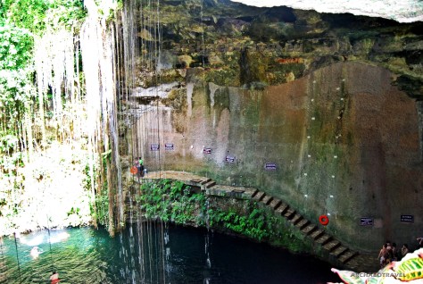
Cenote Sagrado of Chichén Itzá

Similarly to caves, cenotes as sacred wells played very important role in the Mayan mythology and religion (Tuszyńska 2007:142). Cenote Sagrado (Sacred) located in the archaeological zone of Chichén Itzá was a particularly important site in the late Classic Period of Maya culture, that is to say, between the years of 600–900 AD. (Ibid.:142). At that time, the city of Chichén Itzá experienced a heyday, becoming the most powerful Mayan center in the Yucatan (Ibid.:142). And so the Cenote Sagrado did (Ibid.:142). First, it was a center of religious rituals, and in the post-classical period (850-fifteenth century AD.), it became in turn a famous destination of pilgrimage for the faithful from the areas of today’s Mexico and Guatemala, but also from lands as distant as Costa Rica and Panama or even the south-western areas of today’s United States (Ibid.:142).

The Sacred Cenote at Chichen Itza, Mexico. “Cenote de los Sacrificios” at Chichén Itzá, Yucatán Peninsula, Mexico. A karst lake, reflecting the karst’s water table. Photo by Ekehnel (Emil Kehnel) (2008). CC BY 3.0. Drawing source: “Cenote” (2020). In: Wikipedia. The Free Encyclopedia.

Diego de Landa (1524-1579), Spanish bishop of the Roman Catholic Archdiocese of Yucatán, mentioned the great importance of the holy well at Chichén Itzá (Tuszyńska 2007:142). He describes pilgrimages of the faithful with various offerings, still taking place in the sixteenth century (Brady 2013:305). The cenote has a diameter of 60 meters, its depth reaches 13.5 meters, and the water level is about 22 meters below the ground (Tuszyńska 2007:142). The cenote‘s round eye might have been reminiscent of a mirror, which the Mayans used for prophecy and foretelling the future (Ibid.:142).

Venturing out into the earth

At the beginning of the twentieth century, Edward Herbert Thompson (1857 – 1935) an American consul to Yucatan and archaeologist, verifying De Landa’s written records, excavated many artifacts from the bottom of the natural well; here and in other cenotes in Yucatan, there were numerous artifacts of gold, jade, obsidian, rock crystal, shells, flint, wood, clay, gold, hematite, animal bones and tombac, and even scraps of fabric (Tuszyńska 2007:142; Brady 2013:305-307). Among the artifacts found in the Cenote of Chichén Itzá, there are beautiful discs made of turquoise, pyrite, coral and shells (Tuszyńska 2007:142). Sacrificial objects, along with ceremonial instruments were also found in other hard-to-reach places underground as caves; they were, as in the case of votives in the Catholic Church, offered for various intentions or for gratitude (Tuszyńska 2007:142; Brady 2013:307). Such archaeological finds also testify to the religious determination of the Maya, who were able to venture out into the earth to sixteen kilometres deep, in the search of their gods, lighting their way just with torches (Brady 2013:307).

The Sacred Cenote at Chichen Itza with a temple dedicated to rain deities beside. Photo by Salhedine (2005). CC BY-SA 4.0. Photo source:“Sacred Cenote“ (2020). In: Wikipedia. The Free Encyclopedia.

On the whole. Edward Thompson’s archaeological work confirmed the importance of the sacred cenote at Chichén Itzá as a place of pilgrimage for many generations (Tuszyńska 2007:142; Brady 2013:305). These and other studies have equally proved that religion was one of the most important institutions in the ancient Mayan society, and it was strongly related to such natural formations as caves or cenotes (Brady 2013:278,305-307).

Modern tourist attractions

Filtered through the limestone deposits in cenotes, the water in such natural wells is still crystal-clear (Dzikowska 2013:201). This is why, these days private and public cenotes greatly attract swimming and snorkelling tourists, along with cavern and cave divers (“Cenote” 2020). Some areas with such natural wells are also considered as National Natural Parks (Ibid.). Nothing surprising. While exploring cenotes “[great] care should be taken to avoid spoiling [their] fragile ecosystem” (Ibid.). Top recommended cenotes for tourists include but not limited to Cenote San Lorenzo Oxman, La Noria, Dos Ojos Cenote (Sistema Dos Ojos), Cenote Multum Ha, Cenote Choo-Ha, Cenote Azul, the Seven Cenotes of San Gerónimo, Hacienda Mucuyché, Tulum’s ‘Car Wash’, Dos Ojos Cenote (Sistema Dos Ojos), and Cenote Chichi de los Lagos, Homun (private cenote) (BeFree and Travel 2017; Spechler 2020).

Featured image: One of numerous cenotes on Yucatan Peninsula. Photo by MarcTran (2019). Photo source: Free images at Pixabay.

By Joanna
Faculties of English Philology, History of Art and Archaeology.
University of Silesia in Katowice, Poland;
Cardinal Stefan Wyszyński University in Warsaw, Poland;
University College Dublin, Ireland.

BIBLIOGRAPHY:

“Cenote” (2020). In: Wikipedia. The Free Encyclopedia. Available at <http://bit.ly/2L9bXVb>. [Accessed on 30th December, 2020].

“Altepetl” (2020). In: Wikipedia. The Free Encyclopedia. Available at <http://bit.ly/2MqX1mc>. [Accessed on 2nd January, 2021].

“Cenote” (Polish) (2020). In: Wikipedia. The Free Encyclopedia. Available at <http://bit.ly/3hCDjzp>. [Accessed on 2nd January, 2021].

“Sacred Cenote“ (2020). In: Wikipedia. The Free Encyclopedia. Available at <http://bit.ly/3pLHKuH>. [Accessed on 2nd January, 2021].

BeFree and Travel (2017). “8 Top Cenotes”. In: BeFree and Travel. Youtube Channel. Available at <https://bit.ly/2KOe5BZ>. [Accessed on 30th December, 2020].

Brady J. E. (2013). ”Odkrywanie ciemnych sekretów – archeolodzy w jaskiniach Majów.” Jawińska M. trans. In Majowie. Niezwykła cywilizacja. [Maya. Gottkonige im Regenwald]. Grube N., Eggenbrecht E., Seidl M. eds. Warszawa: Grupa Wydawnicza Foksal.

Doyle J. (2018). “Into the Centipede’s Jaws: Sumptuous Offerings from the Sacred Cenote at Chichén Itzá”. In: The Metropolitan Museum (The MET). Available at <http://bit.ly/38Wkvae>. [Accessed on 1st January, 2021].

Dzikowska E. (2013). Tam, gdzie byłam. Meksyk. Ameryka Środkowa. Karaiby. Wydawnictwo Bernardinum.

Grube N., Eggenbrecht E., Seidl M. eds. (2013). ”Słowniczek.”Jawińska M. trans. In Majowie. Niezwykła cywilizacja. [Maya. Göttkonige im Regenwald]. Warszawa: Grupa Wydawnicza Foksal.

Spechler D. (2020). “Visit these breathtaking underwater caves in the Yucatán Peninsula. From Maya temples to a makeshift car wash, these four cenotes offer outdoor adventure, fascinating history, and traditional culture”. In: Travel. National Geographic. Available at <http://on.natgeo.com/3n4lqud>. [Accessed on 30th December, 2020].

Tuszyńska B. (2007). Mitologie świata: Majowie. In: Rzeczpospolita. Kraków: Drukarnia Narodowa SA.

Von Daniken E. (1991). Dzień, w którym przybyli bogowie. 11 sierpnia 3114 roku prz. Chr. [Der Tag, and em die Gotter kamen. 11. August 3114 v. Chr.]. Serafińska T. trans. Warszawa: Wydawnictwo Prokop.

Votive offerings or Deposits in Ancient and Modern Societies

From Latin: ex voto – ‘by vow’

A religious object for a specific intention or as an expression of gratitude, or as a means of giving thanks for the fulfillment of a wish. They can include “one or more objects displayed or deposited, without the intention of recovery or use” (“Votive offering” 2021). Such votive objects or offerings are usually dedicated to gods (in polytheism) or to the God or saints (in Christianity) in a shrine, temple or a church, or others places of pilgrimage.

In pagan antiquity, a votive was often a symbolic offering, given to a deity or deities as a thanksgiving (agalma) or in order to ask for answering the faithfuls’ prayers. It was usually in the form of small terracotta or metal (bronze, lead) figures or body parts made of clay, and even vessels. The more rare form of votive offerings were statues or small buildings.

Christian religious offerings are symbolic items related to a specific intentions of the faithful or their gratitude for all that they have received from the God. Christian votive objects can take various forms, usually of devotional articles, such as lit candles and rosaries.

Featured image: Our Lady of San Juan de los Lagos votive; a Mexican votive painting of 1911; the man survived an attack by a bull. Photo by Andreas Praefcke (2008). Photo and caption source: “Votive offering” (2021). In: Wikipedia. The Free Encyclopedia.

BIBLIOGRAPHY:

“Votive offering” (2021). In: Wikipedia. The Free Encyclopedia. Available at <https://bit.ly/2V0oAHK>. [Accessed 28th August, 2021].

“Dar wotywny” (2021). In: Wikipedia. Wolna Encyklopedia. Available at <https://bit.ly/3DqhoWt>. [Accessed 28th August, 2021].

Lucie-Smith, E. (2003) The Thames & Hudson Dictionary of Art Terms. London: Thames & Hudson World of Art, p. 227.

Royal Terraces without a Palace of the Kings

We had just left behind a stone forest of the fifty-four towers of the State Temple of Bayon, situated at the very heart of Angkor Thom. They followed us with the eyes of the faces looking out to the Baphuon Temple, and further on to the North Gate.

The both temples, Bayon and Baphuon, are definitely the most beautiful and complete in comparison to other numerous remains of temples and secular structures of different ages and styles scattered around Angkor Thom (Teo 2014); there are ruins of Prasat Chrung, composed of “four temples located at the corners of the wall, in southwest, northwest, northeast, and southeast” (Ibid.), then Preah Pithu Group, Prasat Suor Prat, the Khleangs, Tep Pranam, the so-called Monuments 486 and 487, and the Royal Palace area with the Royal Chapel of Phimeanakas and two monumental terraces (Renown Travel & Tour Agency 2010-2020; Teo 2014).

Perished Palace of Angkor Thom

The city of Angkor Tom “was [once] inhabited by tens of thousands of common people who lived in wooden houses, that have long gone. The city was highly developed with a system of roads and waterways, as well as four hospitals” (Renown Travel & Tour Agency 2010-2020).

One of the main stairway leading to the Terrace of the Elephants. Photo by Diego Delso (2013). CC BY-SA 3.0. Colours intensified. Photo source: “Terrace of the Elephants” (2020). In: Wikipedia. The Free Encyclopedia.

The city of Angkor Thom was not evenly covered with ever-lasting stone structures; in comparison to southern part of Angkor Tom, which seems now desolate, the northern side of the city abounds in various architectural creations, unfortunately now mostly in ruins. To the North of the Bayon the king Jayavarman VII built his Royal Palace (Renown Travel & Tour Agency 2010-2020). “Since it was built of perishable materials as were other urban constructions, nothing of it remains today except for the Royal Terraces that were made of stone” (Renown Travel & Tour Agency 2010-2020; see Pałkiewicz 2007:176). Consequently, both the Elephants’ Terrace and the Leper King’s Terrace has still marked the eastern extremity of the Royal Palace enclosure (Ibid.).

Terrace of the Elephants

We walked to the north, from Baphuon in the direction of Phimeanakas, two former state temples incorporated to the twelfth century’s Royal Palace (“Angkor Thom” 2020). There is a huge square adjoining the Terrace of the Elephants (Teo 2014). Its two and a half-meter tall edifice is really impressive: it extends in length for over three hundred metres; we observed that it already starts at the foot of the Baphuon Temple and reaches northwards to the second Terrace of the Leper King (Glaize 1944; Teo 2014).

Terrace of the Elephants’ long wall is adorned with intricate carvings, major part of which represents royal and holy animals – elephants, which proudly walk along the terrace’s pedestal. Photo by Marcin Konsek (2016). CC BY-SA 4.0. Colours intensified. Photo source:Wikipedia. The Free Encyclopedia.

Nevertheless, these two boundaries of its large architectural construction “remain imprecise in their layout and the terrace itself shows evidence of additions and alterations” (Glaize I 1944), made partially by Jayavarman VII in the late twelfth century, and then continued by his successor (Teo 2014).

Elephants everywhere

The terrace’s long wall is adorned with intricate carvings, major part of which represents royal and holy animals – elephants, which proudly walk along the terrace’s pedestal (Pałkiewicz 2007:165). Hence the terrace’s name (Ibid.:165). During the golden age, the royal cavalry consisted of two hundred thousand elephants, the pride of the army, as well as a large number of horses, oxen and carts (Ibid.:170).

Often the result of a battle depended on the number of elephants that took part in it (Pałkiewicz 2007:170). Wars on land usually started in the dry season, which made it easier for the troops with elephants to move quicker around (Ibid.:170). During the battle, clouds of dust stirred up by elephants rose in the air, which, as the verses of an epic Khmer poem say, even covered the Sun (Ibid.:170).

Five-headed horse

The terrace’s wall spans the front of Baphuon Temple, the Royal Chapel of Phimeanakas and the Royal Palace area in the centre of Angkor Thom (Teo 2014). The northern segment of the wall (a part of an ancient façade) shows a panel densely decorated in high relief with the five-headed horse, around which there are complex, possibly mythological scenes (Glaize I 1944; Teo 2014): “the king’s horse sheltered under tiered parasols, […] surrounded by apsaras and menacing genies armed with sticks who chase some terrified smaller figures” (Glaize I 1944). Three sections of retaining walls of the Terrace of the Elephants together with its two side walls compose five outworks extending towards the square in the centre (Glaize I 1944; Teo 2014).

Terrace of the Elephants, Angkor Thom, Cambodia. Photo by Diego Delso (2013). CC BY-SA 3.0. Colours intensified. Photo source: “Angkor Thom” (2020). In: Wikipedia. The Free Encyclopedia.

Their middle sections are covered in life size legendary Hindu bird-like creatures, called Garudas, and lions, all depicted in the pose of atlantes (Glaize I 1944; Teo 2014). Towards either end of the wall, the entire length of the panel is sculpted in a high relief, representing a parade of nearly full in size elephants depicted in profile and mounted by famous Khmer mahouts (Glaize I 1944; Teo 2014). Various level changes in the wall are in turn ”marked with lions sculpted in the round and Naga-balustrades on blocks with [their opponents, Garudas], on the [snakes’] hoods” (Glaize I 1944).

Three-headed elephant

The Terrace is double-levelled, and its upper part has furthermore two levels with an elevated platform, whose base is carved with Hamsas (sacred geese) (Glaize I 1944).

Three-headed elephant from the Terrace of the Elephants, Angkor Thom, Cambodia. Photo by Anita (2014). In: kolibri5. Photo source: Free images at Pixabay.

Five stairways, as many as there are gates to the city, lead to the Terrace of the Elephants (Glaize I 1944). They are all also fully covered in carvings but three of the staircases seem most dominant of all (Ibid.). The southern one displays exceptionally beautiful sculpture (Ibid.), namely, it is “framed by motifs of [a three-headed elephant, Airvan], with trunks forming pillars tugging at lotuses, [the sculpture already found on the gates of Angkor Thom] (see Passageway through the Stargate). The same arrangement can be seen on the two secondary stairways which frame the central perron” (Ibid.). The stairway on the northern façade is partly sculpted in a bas-relief of horizontal bands; there are “scenes of sport, wrestling, chariot racing and polo, […] which originated from India” (Ibid.).

Royal stand

Around eight hundred years ago, the Terrace of the Elephants must have been a spectacular meeting place (Teo 2014); it was probably “used as a giant reviewing stand for [spectacles], public [and religious] ceremonies, and served as a base for the king’s grand audience hall” (Teo 2014; see Pałkiewicz 2007:165). Triumphant military parades and colourful spectacles took place at its foot, and despite the fact that the construction had been damaged many times, its majestic appearance still makes a great impression (Pałkiewicz 2007:165). The bas-reliefs of the Terrace of the Elephants, and the whole Angkor Tom, show how great the magnificence of the royal court of Khmers really was (Ibid.:170).

Terrace of the Elephants is the largest of the two in Angkor Thom. It is compsed of five outworks with five stairways leading to double-levelled platform. The terrace may have served as a ceremonial stand. Copyright©Archaeotravel.

A traveller and journalist, Jacek Pałkiewicz (2007:170) imagines the ceremonial protocol of that time: here is the divine ruler with a tiara on his forehead, seated on a high terrace in the shade of ceremonial umbrellas. Handmaids in colourful, silk robes are approaching him, while offering refreshing fruit (Ibid.:170). The king is surrounded by an entourage of clergy, dignitaries and diplomats (Ibid.:170). In their company, the ruler is watching the infantry and cavalry troops heading towards the central Palace (Ibid.:170). Flags and banners are fluttering in the wind (Ibid.:170). It was a real propaganda for the diplomats, envoys and travellers who came from abroad (Ibid.:165,170).

Envoy’s reports

The contemporary chronicles also report a great prosperity in trade in the Khmer Empire (Pałkiewicz 2007: 174). Gold was imported from Sumatra and Korea, tin and fabric from Malaysia, mercury from China and an extremely valuable aromatic tree, silk from India (Ibid.:174). Spices and dyes were transported by water or by carts drawn by Indian buffaloes or by men from lower castes (Ibid.:174).

An envoy from China, Chou Ta Kuan, reports that people from lowest classes in Angkor had dark skin and lived a very simple life (Pałkiewicz 2007: 174). On the other side, aristocrats and inhabitants of the Royal Palace, both men and women fair complexion, which is probably due to the fact that their skin had not been exposed to sunlight (Ibid.:174). Generally, both men and women only wore a loincloth (Ibid.:174). They bound their hair up at the top of the head and walked barefoot, including emperors’ wives (Ibid.:174). According to the envoy’s records, the king had five wives (Ibid.:174). As for concubines and palace maidens, their number ranged from three to five thousand (Ibid.:174). They were divided into many classes, but these women rarely had the opportunity to be in the royal quarters (Ibid.:174). The best noble families competed with each other, offering their daughters to the king, thus seeking privileges (Ibid.:174).

Terrace of the Leper King, Angkor Tom, Cambodia. Photo by Olaf Tausch (2015). CC BY-SA 3.0. Colours intensified. Photo source: “Angkor Thom” (2020). In: Wikipedia. The Free Encyclopedia.

Apart from the being admired at his Terrace of the Elephants, the king equally gave audiences twice a day at his Royal Palace, which, unfortunately, no longer exists (Pałkiewicz 2007: 170). Chou Ta Kuan writes that this Palace had colourful interiors decorated with wood and gold (Ibid.:170). And the king himself, during the audience, appeared in the window with golden cornices, holding his sword in his hand (Ibid.:170,174). The entire ceremony was performed to the accompaniment of music (Ibid.:170). After being summoned by the king, a minister or another official sat on a tiger’s skin before the king and submitted interpellations (Ibid.:174). While leaving the site, I thought about a mystery of those ancient times, yet brining back in such details by the envoy’s contemporary reports and magical movements and dance of the sculpted stone figures frozen in the past.

Terrace of the Leper King

Soon we reached the second terrace of the Royal Palace, called the Terrace of the Leper King, situated at the north end of the Terrace of the Elephants (Teo 2014); it is aligned with it but forming a separate architectural unit of twenty-five metres wide by six metres high (Glaize II 1944). The Terrace resembles a bastion, which is entirely sculpted in the mixture of high and low relief (Ibid.). All the filigree carvings are depicted in five visible registers (Maurice Glaize II (1944) mentions seven); unfortunately, some of the sculpture, especially the uppermost, is strongly damaged or worn out, and thus hardy readable (Glaize II 1944; Pałkiewicz 2007:174).

Dense sculpture encrusting the Terrace of the Leper King in Angkor Thom, Cambodia. Photo by one_life (2016). Free images at Pixabay.

Both the internal and external reliefs show lines of seated mythological figures of Naga, Garuda, and Kumbhanda (Glaize II 1944). There are also meditating silhouettes of women, images of monarchs in crowns, armed with short swords, various species of animals, hunting scenes, games and activities (Pałkiewicz 2007:174,176). All of them “haunt the flanks of Mount Meru, shown as giants, […] sometimes with multiple arms […], sword or club bearers, and women with bare torsos” (Glaize II 1944).

Apsaras in pearls

When I approached the construction from its north side I saw yet different looking sculpture; there was a sword swallower and some figures wearing a curious side-chignon, who kept following him (Glaize II 1944). Having moved to the south side, I entered the internal corridor or passage dividing the carved mound in two (Glaize II 1944; Pałkiewicz 2007:176). I admired a well preserved set of carvings whose décor is composed of the same elements as the exterior but it is additionally adorned with my favourite Hindu characters, graceful and benevolent Devi, also called Apsaras (Glaize II 1944).

The summer light penetrating from the above fell on the sculptures covering the interior walls, emphasizing the shapely naked breasts of charming female upper bodies adorned only with strings of pearls (Glaize II 1944; Pałkiewicz 2007:176) and “triangular head dress with flaming discs” (Glaize II 1944). Some sculpted characters on the south side were also seated upon a lower frieze built up of depictions of fish, elephants and a river running vertically (Ibid.).

Leper King

Following the rows of scenes, I eventually climbed laterite steps to the upper level of the Terrace, where “[surrounded by three smaller decapitated statues carrying clubs on their right shoulders, the ‘Leper King’ sits in the Javanese manner with his right knee raised” (Glaize II 1944). Possibly his position has originally been on a simple stone slab he is seated on (Ibid.). The sculpture is itself unique in Khmer art, as it represents the King entirely naked, with no trace of his genitalia though (Ibid.).

Seated statue (a copy) venerated in Buddhist orange clothes in the photo gives the Terrace of the Leper King its name. Photo by McKay Savage (2009). CC BY 2.0. Colours intensified. Photo source: “Terrace of the Leper King” (2020). In: Wikipedia. The Free Encyclopedia.

I looked at the figure and I immediately got an impression he is smiling, pleased with his entourage and location, or maybe visitors taking him loads of photos. When I started wondering why the seated figure is called the Leper King, I unexpectedly found the answer to my question: although the figure has no sign of leprosy as such, it is discoloured. Anyway, the original sculpture of the ‘King’ had already been replaced with a copy (Pałkiewicz 2007:174); “[the] statue was moved from the Terrace in Angkor Thom to the National Museum in Phnom Penh” (Miura 2015).

The statue which gave the Terrace of the Leaper King its name has been replaced by a replica. Photo by Serinde (2004). Public domain. Colours intensified. Photo source: “Terrace of the Leper King” (2020). In: Wikipedia. The Free Encyclopedia.

Maurice Glaize (II:1944), as a French architect, archaeologist, and Conservator of Angkor from 1937 to 1945, had an opportunity to describe the original statue in his the guidebooks to the Angkor monuments. He writes that besides being stained and disfigured, it also bears a few patches of lichen, which may have resembled a person with leprosy (Glaize II:1944; see Pałkiewicz 2007:174). The source of the King’s and thus the Terrace’s name could be also because of a Cambodian legend of an Angkorian king, Yasovarman I (889–910 AD.), who was a great creator of Angkor and possibly he died of leprosy (“Terrace of the Leper King” 2020; Pałkiewicz 2007:174). Consequently, he went down in history as the Leper King (“Terrace of the Leper King” 2020; Pałkiewicz 2007:174). Yet, he had reigned much earlier than the Terrace was constructed in the late twelfth century.

Sculpture of the so-called Leper King from the Terrace named after that figure. Does he really represent a king? Or maybe a demon or the god of the dead? Copyright©Archaeotravel.

After some scholars neither the statue represents a leper nor a king. Actually, the identity of the sculptured character is unknown. It is held by some that it represents ‘Shiva ascetic’, others believe that a later inscription on the Terrace’s base, which reads a ‘Dharmaraja’ reveals the statue’s real name (Glaize II:1944).“[It] is sometimes given to Yama and sometimes to one of his assessors – ‘the Inspector of Qualities and Faults’ – the supreme judge in the hour of judgement, [and so] the ‘god of the Dead’” (Ibid.). However, the hairstyle of the individual, namely composed “of thick coils starting from the front and covering the nape of the neck – emphasises, like the two ‘fangs’ near the corner of the lips, his demonic character” (Ibid.). Is it then one of demons from Hindu tradition? Is it maybe a depiction of Ravana?

Dharmaraja at Mount Meru

It is probable that the Terrace of the Leper King was once dominated by the sculpted mound, possibly complemented with pools, and with the buried wall; this curious arrangement may have been a symbolic representation of Mount Meru (Glaize 1944).

On the other side, “the fact that it occupies an area to the north of the Royal Palace – the area […] reserved still now for royal cremations known as ‘Val Prah Men’ (the name of the pavilion prepared there for the funeral pyre) – leads one to suspect that the Terrace of the Leper King was none other than a permanent [Val Prah] Men, which would explain why, when this cult was still remembered [in the fifteenth century, the name] of Dharmaraja [as the god of the dead, had been] placed [just] there” (Ibid.).

Ancient heritage

From the main entrance to the Royal Palace, that is halfway along the wall of the Terrace of the Elephants, there is an almost one and half kilometre long Victory Way that leads to the fifth and most important passage within the citadel of Angkor Thom, the Victory Gate or the Fifth Gopura (Pałkiewicz 2007:176).

Following the road I kept passing by numerous remains of ancient structures of Prasat Suor Prat, plunged in the greenery, and I was thinking about their links to modern times of Cambodia. I looked around and except for tourists from abroad, there were many Khmers visiting the city. Contemporary inhabitants of the country, although fiercely experienced by the regime of the Red Khmers, are still very proud of the ancient past of their country, and happy to show that it boasts a great medieval culture, as does Europe (Pałkiewicz 2007:176).

Featured image: Devi, also called Apsaras among the sculpture from the Terrace of the Leper King; the inside passage. Copyright©Archaeotravel.

By Joanna
Faculties of English Philology, History of Art and Archaeology.
University of Silesia in Katowice, Poland;
Cardinal Stefan Wyszyński University in Warsaw, Poland;
University College Dublin, Ireland.

BIBLIOGRAPHY:

“Angkor Thom” (2020). In: Wikipedia. The Free Encyclopedia. Available at <https://bit.ly/3nWh1KB>. [Accessed 20th January, 2021].

“Terrace of the Elephants” (2020). In: Wikipedia. The Free Encyclopedia. Available at <https://bit.ly/3c1NhcZ>. [Accessed 20th January, 2021].

“Terrace of the Leper King” (2020). In: Wikipedia. The Free Encyclopedia. Available at <https://bit.ly/3bYB3Sa>. [Accessed 20th January, 2021].

Free images at Pixabay. Available at <https://bit.ly/3fTQX0u >. [Accessed on 17th August, 2021].

Glaize M. (I) (1944). “A Guide to the Angkor Monuments (Translation NT); Part Two: The Royal Square: the Terrace of the Elephants”. In: The Angkor Guide. Available at <http://www.theangkorguide.com/text.htm>. [Accessed 19th January, 2021].

Glaize M. (II) (1944). “A Guide to the Angkor Monuments (Translation NT): Part Two: The Royal Square: the Terrace of the Leper King”. In: The Angkor Guide. Available at <http://www.theangkorguide.com/text.htm>. [Accessed 19th January, 2021].

Konsek M. (2014). Photo: “Angkor, Angkor Thom, Taras Słoni”. In: Wikipedia. The Free Encyclopedia. Available at <https://bit.ly/3sOEZLx>. [Accessed 20th January, 2021].

Miura K. (2015). “From “Originals” to Replicas: Diverse Significance of Khmer Statues”. In: Kultur als Eigentum: Instrumente, Querschnitte und Fallstudie [online]. Growth S., Bendix R. F. and Spiller A. (dir.). Göttingen: Göttingen University Press. (generated 10 September 2020). ISBN: 9782821875500. Available at <http://books.openedition.org/gup/550>. [Accessed 20th January, 2021].

Pałkiewicz J. (2007). Angkor. Poznań: Zysk i S-ka Wydawnictwo.

Renown Travel & Tour Agency (2010-2020). “Angkor Thom”. In: Renown Travel. Available at <https://bit.ly/2YiBz5L>. [Accessed 18th January, 2021].

Teo R. (2014). “Gates of Angkor Thom”. In: Reubenteophotography. Available at <https://bit.ly/2YiYoXa>. [Accessed 18th January, 2021].

Jamb of a Window and a Door in Architecture

The term jamb stands for a recess between the wall face inside the room and the side of a fitted window (window jamb) or door (door jamb) or other wall opening.

The jamb on a medieval church doorway (in a Gothic portal accompanied by lintel and trumeau) is normally occupied by a cascading row of carved figures. “These [jamb] statues are often human figures, typically religious figures or secular or ecclesiastical leaders” (“Jamb statue” 2020). Such jamb figures are very often visible in Gothic cathedrals of France and elsewhere in medieval Europe.

Featured image: The fragment of the West Portal of the Cathedral Notre Dame de Paris, France. The portal is occupied by the so-called jamb figures of saints and angels, which is typical of the French style of medieval architecture. The figures are positioned below the so-called capitals. Above them, there is a fragment of a beautifully carved archivolt and of the tympanum. Copyright©Archaeotravel.

BIBLIOGRAPHY:

“Framuga” (2020). In: Wikipedia. Wolna Encyklopedia. Available at <https://bit.ly/3y6hjn8>. [Accessed 21st August, 2021].

“Jamb statue” (2020). In: Wikipedia. The Free Encyclopedia. Available at <https://bit.ly/3miJYTK>. [Accessed 21st August, 2021].

Lucie-Smith, E. (2003) The Thames & Hudson Dictionary of Art Terms. London: Thames & Hudson World of Art, p. 122.

Magic in the Hag’s Cairn of the Loughcrew Hills at the Equinox Rising Sun

Within the Loughcrew complex, Cairn T (Hag’s Cairn), which is situated on Carnbane East, is the most outstanding of all (see: Sliabh na Callighe (Mountains of the Witch). As if it had been designed as an astronomical construct, the mound “stands in the focal position and takes the most prominent place on the highest summit of a megalithic area” (Brennan 1994:46). Originally there were fifty to a hundred mounds (Ibid.). In the seven remaining mounds, sufficient stones are in their original alignment for a beam of light to be projected into the chamber and against the backstone, presenting a clearly defined frame of light (Ibid.). The number of remaining mounds allows to reconstruct the main elements in a planned astronomical and calendrical scheme.

Major mounds and their satellites

In 1980, two researchers, Martin Brennan and Jack Roberts studied the two most important cairns at Loughcrew, T and L, which are supplemented by smaller satellite mounds linked to their larger counterparts by orientation and alignment (Brennan 1994:46-50). “Cairns L and T – [initially] appeared to be oriented in the same direction according to archaeological surveys done before 1980s, however, [the explorers have eventually concluded that] in terms of real function, the equinox rising sun is focused on Cairn T, but does not approach anywhere near the passage of Cairn L” (Brennan 1994:48).

While conducting their studies, the both researchers had encountered similar problems as we did during our study trip, while they were trying to reach the Cairn T in March to observe the spring equinox (see: Sliabh na Callighe (Mountains of the Witch). Martin Brennan (1994:46) writes that “the mountains were covered in snow and the […] winds from the east blew icy gusts down the passage of the mound.” Actually, 5000 years ago the climate was more favourable to celebrate the spring equinox.

What does the equinox mean?

“Equinox literally means equal night. In terms of hours, equinox is the date, when the hours of day and night are equal. The two extremes of this are winter solstice, when the night is longest, and summer solstice, when the night is shortest” (Brennan 1994:90). So equinox (spring and autumnal) is midway between these two points (Ibid.:90). “At equinox the sun is raising due east to the horizon” (Ibid.:90).

Hag’s Cairn

As the major mound, Cairn T “dominates a group of smaller satellite mounds clustered around it on the summit of the Mountain of the Sorceress, [called like that for the mentioned reasons (see: Sliabh na Callighe (Mountains of the Witch)]” (Brennan 1994:48). It is orientated about nine degrees south of east and above the horizon (Ibid.:90). Therefore “the beam [of light] does not enter the mound until the sun rises to the proper altitude. At the spring equinox the angle of the sun’s path is very high in relation to the horizon, whereas at the autumnal equinox the angle of the ecliptic is lower. […] What [one can witness] at Cairn T [at the equinox is] the intended projection of light and its interaction with [the carved symbols]” (Ibid.:90).

Views from Loughcrew Passage Tomb near Oldcastle, County Meath. Photo by Stephen Keaveny (2014). CC BY-SA 4.0. Photo source: “Loughcrew” (2020). In: Wikipedia. The Free Encyclopedia.

During their research at the time of the spring equinox, Brennan and Roberts noticed a rectangular patch of light on the upper left of the backstone inside the Cairn T (Brennan 1994:47,93). It was starting to take a regular form, “brilliantly illuminating the entire chamber in a glowing splendour of shimmering golden orange light” (Ibid.). As the researchers notice, it gives a different effect from the one observed at Newgrange at the winter solstice. Whereas in the latter, the beam of light sweeps across the chamber, inside the Cairn T at Loughcrew, “the light [assumes] a clearly defined geometric shape that [is] projected on to the upright backstone and [moves] diagonally across it, tracing the path of the sun against a mural of prehistoric art” (Ibid.).

Encrypted message of Loughcrew?

“The arrangement of the engravings in relation to the sunbeam reveals that there is quite precise time reckoning and careful determination of the equinoxes” (Brennan 1994:92). The beam of light is concentrated on one stone at the back of the passage chamber (C8) and in its journey it progresses from left to right (Ibid.:94). Finally it gradually moves down the stone, “reflecting the movement of the rising sun” (Ibid.:94) and “illuminating key symbols as it progresses” (Ibid.:92). “It is the beam of light itself which finally and conclusively identifies the inscriptions as solar symbols” (Ibid.:94). The focal point of the entire process is a petroglyph representing “a large circular radial sun on the right of the stone” (Ibid.:93; see 94).   

The researchers were highly impressed by the observed phenomenon, where the sliding beam of light played the role of a guide or key to the encrypted message left by the builders of Loughcrew. In this context, the petroglyphs on the backstone (C8)  in Cairn T may “be interpreted as the language of unknown archaic astronomers” (Brennan 1994:92).

“For the first time we were seeing the signs and symbols in the context in which the artist had meant them to be seen. Suddenly markings that had appeared to be random and haphazard became part of an intricately structured system that derived its meaning from the solar event we were witnessing” (Brennan 1994:47)

Cairn T at Loughcrew. Photo by William Whyte from Dublin, Ireland (2008). CC BY-SA 2.0. “Loughcrew” (2019). In. Wikipedia. Wolna Encyklopedia.

Furthermore, the entrance stones and the narrow passage shape the beam of light into a regular geometric form of a rectangle (Brennan 1994:94). At the end it disintegrates in the process of moving on the right and away from stone C8 (Ibid.:94). The rectangular shape reconstructs itself reaching stone C10 (Ibid.:94). At autumnal equinox the process is repeated (research carried out at the site on 22nd September, 1980 by Martin Brennan and Jack Roberts) (Ibid.:98). “The beam of light clearly centres on the sun’s disc, repeating the imagery of the spring equinox. [Although the] focal image in both events remains the same, […] different sets of engravings are utilized to measure the beam of light” (Ibid.:98). With the same width of the beam as at spring equinox, at the autumnal its length changes and is about double as it is in the spring (Ibid.:98). In both cases, however, “the illumination of the sun wheel unambiguously links the prehistoric art and the astronomy” (Ibid.:100).

Precise solar construct

According to the results of research done at the site on 20th March in 1980 (on the day of the spring equinox), Cairn T turned out to be a precise astronomical instrument or a solar construct (Brennan 1994:48). Combined with the prehistoric petroglyphs, the visible differences in the movement of the sunlight on the backstone made it far easier and more precise in identifying the actual day of equinox  at Loughcrew than the day of winter solstice at Newgrange (Ibid.).

Epitaph for Jeremiah …?

Michelangelo, Jeremiah from the Sistine Chapel ceiling (1508-1512). The Yorck Project (2002) 10.000 Meisterwerke der Malerei (DVD-ROM), distributed by DIRECTMEDIA Publishing GmbH. Public domain. Colours intensified. Photo source: “Jeremiah” (2021). In: Wikipedia. The Free Encyclopedia.

There is a growing belief that Cairn T is actually the burial place of the Bible Prophet, Jeremiah! Some authors claim that Jeremiah’s message is encoded in the petroglyphs inside the entrance to the Cairn and that they even reveal the exact date of his death on 21st of September in 581 BC (JAH 1998-2006; O’Bryan 2017). According to the same authors, the Cairn T itself would have been designed to demonstrate the autumnal equinox just in memory to the Prophet (JAH 1998-2006). “These are the same [authors] who also believe that the Ark of the Covenant is buried on the Hill of Tara” (Murphy 2017-2020).

Jeremiah was the Jewish prophet known from the Old Testament from his prophecy of the destruction of Jerusalem (O’Bryan 2017). According to one of the versions reporting a possible story of the lost Ark of the Covenant, Jeremiah may have been a person who escaped Jerusalem with the Ark in 587 BC (Ibid.). It may have happened just before “the Babylonians under Nebuchadnezzar took the city and destroyed the First Temple” (Ibid.). After the Book of Jeremiah, the Prophet escaped the conquered city together with other Israelites, among whom there was a Jewish princess and the scribe Baruch (JAH 1998-2006; O’Bryan 2017). As the legend says, the group sailed to Ireland, after stopping in Egypt (possibly Tanis) (JAH 1998-2006; O’Bryan 2017) Other accounts state, however, that the Israelites actually headed off to the south, in the direction of Abyssinia (today Ethiopia).

Bethel aka Stone of Destiny

Dipre (D’Ypre), Nicolas. 1495–1531. Jacob’s dream of a ladder. Avignon. Musée du Petit Palais. Photo uploaded by Eugene (2011). Public domain {{PD-US}}. Photo source: Wikimedia Commons.

It is also believed that Jeremiah brought to Ireland the Stone of Destiny aka Jacob’s Pillar, which was once used by the biblical patriarch Jacob (Genesis 28:11-22) as a pillow while he was dreaming of angels ascending and descending on a ladder suspended between the Earth and Heavens (JAH 1998-2006; Gilbert 2015). Jacob thought he had found himself at the door to God’s realm and so he put the stone in a vertical position and called the place the Bethel, which means the House of God (Gilbert 2015). The Stone of Destiny, in turn, was called in Irish Lia Fáil, which means the Speaking Stone or the Stone that Roared to give an explanation for its oracular function (JAH 1998-2006; Keyser 1999-2009). It is believed that it became later the coronation stone for the High Kings of Ireland (Keyser 1999-2009; Gilbert 2017). Herbert W. Armstrong writes that “many kings in the history of Ireland, Scotland, and England have been coronated over this stone – including the present queen. The stone rests today in Westminster Abbey in London, and the coronation chair is built over and around it” (Keyser 1999-2009). Additionally, the stone has got the plate behind it labelling it as ‘Bethel’ (Gilbert 2017).

Jeremiah, Ollamh Fodhla and Tuatha de Danann

Illustration of the Stone of Scone in the Coronation Chair at Westminster Abbey, 1855. Anonymous engraver. The History of England (1859) by D. Hume, continued by T. Smollett, E. Farr and E.H. Nolan Also published in The Queens of England (c. 1889) by Sydney Wilmot. Uploaded in 2006 and in 2016. Public domain {{PD-US}}. Colours intensified. Image source: “Stone of Scone” (2021). In: Wikipedia. The Free Encyclopedia.

Some authors look for evidence for the story in Irish Annals. None of those refers to Jeremiah (Keyser 1999-2009). However, the Annals of Clonmacnoise mentions a mysterious personage of Ollamh Fodhla who appeared on the Island accompanied by an Oriental princess (Gilbert 2015). As the story goes they brought to its shore ancient relics: a harp, chest and a stone (Ibid.). A leading authority on Irish history, Roderic O’Flaherty, however, states that Ollamh Fodhla could not be the same person as Jeremiah due to completely different origins and lifetime of both characters (Keyser 1999-2009). Some scholars also suggest that the Stone of Destiny was brought to Ireland already prior to 700 BC by mysterious people, the Irish myths refer to as Tuatha de Danann – a supernatural race who came to Ireland in ships (Gilbert 2015). It is suggested they were actually representatives of the Tribe of Dan – one of the tribes of Israel, according to the Torah, who had lived along the coast in the north of Israel (today Palestine) (Ibid.). Simultaneously, it was the place where Jacob had got his vision. Israelites from the Tribe of Dan were in danger of becoming captives of other invaders – the Assyrians (Ibid.). As they were excellent sailors, they may have escaped by the sea and reached the shores of Ireland together with their treasure – the Stone of Destiny (Ibid.). In this version, however, Jeremiah could not have played the role he has been ascribed to by the legend.

Replica of the Stone of Scone, Scone Palace, Scotland. The stone rests today in Westminster Abbey in London, and the coronation chair is built over and around it. Additionally, the stone has got the plate behind it labelling it as ‘Bethel’. Photo by Aaron Bradley from Vancouver, Canada (2013). CC BY-SA 2.0. Colours intensified. Photo source: “Stone of Scone” (2021). In: Wikipedia. The Free Encyclopedia.

Just speculations

Although such stories are fascinating, they are decidedly criticized or even ignored by academics. First of all, the Cairn T of Loughcrew was not built as a burial place for Jeremiah or aligned according to the day of his death as it is itself dated back to the second part of the fourth millennium BC, whereas Jeremiah lived in the sixth century BC. Most authors point to the fact that Irish records do not mention Jeremiah’s landing in Ireland or the fact he brought there such treasures as the Bethel or the Arch of Convents (Keyser 1999-2009).

Tuatha Dé Danann as depicted in John Duncan‘s “Riders of the Sidhe” (1911). Public domain. Colours intensified. Painting source: “Tuatha Dé Danann” (2020). In: Wikipedia. The Free Encyclopedia.

The assumption that the Prophet was buried in the Cairn T of  Loughcrew is not borne out either by Irish Annals, petroglyphs of the cairn (unless somebody has deciphered their meaning) or by archaeological evidence. If the Bethel is the same as the Stone of Destiny, which is still under question, it seems more possible it was brought by the Israelites from the Tribe of Dan. Still these are also speculations …

Inside the Cairn T

We did not have a chance to visit Loughcrew in March. Yet I had already climbed up the Hag’s Hill together with my sister when she came to Ireland several months before our study trip. It was in October and we travelled with a group of tourists to the Boyne Valley. The weather was a little bit better than in March. There was a shower from time to time but without strong winds or low temperatures. Still it was wet and some people slipped down the side of the Hill and got covered in mud before they reached its summit. Although the visibility was quite poor because of the mist, we could eventually enter the Cairn T in small groups and admire the mysterious symbols on huge stones inside the passage. Together with my sister we were amazed by their circulating lines, zig-zags and circles engraved in stone. Fascinated with their various shapes I was tracing enigmatic lines with my fingers as if I in hope of understanding the prehistoric writing by touch.

I was tracing enigmatic lines with my fingers as if I in hope of understanding the prehistoric writing by touch . Copyright©Archaeotravel.

Do they contain any encoded messages at all …?

If you would like to experience more the mysteries and ambiance of Loughcrew cairns and face the Witch, you can join us on an archaeological tour : A Tale of the Deeds of Tuatha de Danann and the Formorians – the Race of Giants.

Featured image: Bing Map of the Cairn T at Sliabh na Caillighe (Loughcrew, Ireland). The map created by Archaeotravel by means of the Bing Maps. Copyright©Archaeotravel.

By Joanna
Faculties of English Philology, History of Art and Archaeology.
University of Silesia in Katowice, Poland;
Cardinal Stefan Wyszyński University in Warsaw, Poland;
University College Dublin, Ireland.

BIBLIOGRAPHY:

“Tuatha Dé Danann” (2020). In: Wikipedia. Free Encyclopedia. Available at <https://bit.ly/33haaCw>. [Accessed 14th March, 2020].

“Jeremiah” (2021) Wikipedia. Free Encyclopedia. Available at <http://bit.ly/3buWSJ3>. [Accessed 9th January, 2021].

“Loughcrew” (2020). In: Wikipedia. The Free Encyclopedia. Available at <http://bit.ly/2Xolsmz>. [Accessed 9th January, 2021].

“Loughcrew” (2019). In. Wikipedia. Wolna Encyklopedia. Available at <http://bit.ly/2K0hoWp>. [Accessed 9th January, 2021].

“Stone of Scone” (2021). In: Wikipedia. The Free Encyclopedia. Available at <http://bit.ly/38un5p7>. [Accessed 9th January, 2021].

Brennan M. (1994) The Stones of Time. Calendars, Sundials, and Stone Chambers of Ancient Ireland. Vermont: Inner Traditions International, Rochester.

Dipre (D’Ypre) N. (1495–1531). Jacob’s dream of a ladder. Avignon. Musée du Petit Palais. In: Wikimedia Commons. Available at <https://bit.ly/3aVu9t5>. [Accessed 14th March, 2020].

Gilbert, A. In: Gaunt T. (2015) “The Stone of Jacob” In: Secrets of the Bible. Season 1; Episode 8. Documentary.

Hurson R. (2014). “Entrance carvings Loughcrew Cairn T”. In: Wikimedia Commons. Available at  <https://bit.ly/2Sy4eUx>. [Accessed 29th May, 2021].

JAH (1998-2006) Jeremiah’s Tomb (The Tomb of Ollamh Fodhla). Available at  <https://bit.ly/2U8zCWC>. [Accessed 14th March, 2020].

Keyser J. D. (1999-2009) “The Coronation Stone – Jeremiah in Ireland”. In: Sanders, M. S. Mysteries of the Bible. Available at  <https://bit.ly/39MA7wi>. [Accessed 14th March, 2020].

McCormack L. (2020) “The Autumnal Equinox and the Sliabh na Calliagh Passage Tomb Complex” In: Pilgrimage in Medieval Ireland. Available at <https://bit.ly/2WcTHhi>. [Accessed 14th March, 2020].

Murphy A. (2017-2020) Mythical Ireland. Available at  <https://bit.ly/2WcWAP3>. [Accessed 14th March, 2020].

O’Bryan L. (2017) “Could Ireland’s Cairn T Really Be the Tomb of the Prophet Jeremiah?” In: Ancient Origins. Available at  <https://bit.ly/2xvtDDJ>. [Accessed 14th March, 2020].

Joanna Pyrgies