Category Archives: ASIA

Ancient Lycia in the Middle of Anatolian Traditions

When I now look back over ten years of my archaeological exploration of the world, I distinctly remember my summer travel to Lycian Turkey and its ancient rock-cut tombs encrusting high and steep cliffs. Such monuments of sepulchral architecture are scattered around the whole region of Lycia and partially the neighbouring Caria. They both are located on the south-western coast of Turkey, by the Aegean and Mediterranean Seas, and their mountainous scenery looking out the blue waters is truly breathtaking.

Beautiful view of Marina in Fethiye, Turkey. Copyright©Archaeotravel.

Today, Lycia belongs to the Turkish province of Antalya, and the most frequently visited seaside resorts of the region are definitely tourist Kemer, turquoise Ölüdeniz and peaceful Fethiye, where I stayed in 2008 for over two weeks to explore the region (Miszczak 2009).

Location of Lycia

The area of Lycia occupies the major part of the Teke Peninsula; namely, it is located south of the imagined horizontal line drawn from the town of Köyceğiz to the city of Antalya, where the former is a district of Muğla Province in the Aegean region of Turkey, and the latter – a gateway to Turkey’s southern Mediterranean region (Bean 1989:19; Miszczak 2009). The terrain of Lycia is mountainous to the north, and towards the south, it gradually descends and becomes flat in places along the coast (Miszczak 2009). Much of the area is densely forested (Ibid.). The region of Lycia is geographically featured by two vast masses belonging to Akdağ Mountains; the ancient mountain range of Massicytus expanded to the west and the ancient Solyma, (modern Bey Daği) to the east (Bean 1989:19). Accordingly, Lycia’s borders have been delineated from the south by the Mediterranean Sea, and from the east, north and west by three mountain ranges (Miszczak 2009). Two of them are known today as Boncuk Dağları and Baba Daği – the part of the Taurus Mountains, and the third are the Bey Dağları Mountains (Ibid.). The latter reach even three thousand meters above sea level, and caps of snow lie on their highest peaks until the beginning of summer (Ibid.). The most famous peak of this range is Mount Tahtalı (Ibid.). Owing to these mountain ranges, Lycia was practically cut off from the rest of Anatolia (Bean 1989:19-20; Miszczak 2009). As such, it had won its advantageous strategic location and uniqueness of its culture (Bean 1989:20; Miszczak 2009).

Ölüdeniz Beach in Fethiye District. Photo by Dan Taylor (2004). CC BY 2.0. Photo and caption source: “Fethiye” (2021). In: Wikipedia. The Free Encyclopedia.

Central Lycia consists of many tiny valleys separated by mountains, with the two largest; to the west of Akdağ Mountains, there is the valley of Xanthus, which is a real heart of Lycia, and to the east of Bey Daği is the valley of Alakır (Bean 1989:19; Miszczak 2009). Two major rivers flow through them: Xanthos and Limyrus, the former of which, longer and larger, was called Sibros or Sirbis in ancient times and was the main source of drinking water for the inhabitants of Lycia (Bean 1989:19; Miszczak 2009).

People of Lycia

The region was itself unevenly populated due to its mountainous terrain and most people settled either in main cities along the coast, sometimes still interrupted by the mountains descending directly into the sea, or in the in the valley of Xanthos (Bean 1989:19; Miszczak 2009). In Antiquity, the whole population of the region has been estimated at no more than around two hundred thousand (Bean 1989:19).

Location of Lycia (in red) and Caria at its north-eastern border with the city of Caunus (Dalyan), which once belonged to Lycia. Anatolia/Asia Minor in the Greco-Roman period. The classical regions, including Lycia, and their main settlements. Image by Caliniuc (2018). CC BY-SA 4.0. Photo and caption source: “Lycia” (2021). In: Wikipedia. The Free Encyclopedia.

Ancient Lycians had always been very distinctive in the background of other Anatolian peoples (Bean 1989:19). In ancient times, Lycia was adjacent to Caria region with its ancient city of Caunus to the west and northwest, Pamphylia to the east, and Pisidia to the northeast (Miszczak 2009). Nevertheless, its geopolitical map had often changed throughout ages (Bean 1989:19-30; Miszczak 2009). Although the region is often studied as a whole, the ancient Lycia had never been a single state organism, but well-established federation of city-states (the Lycian League) that pursued a common foreign policy, dictated by their strong instinct for union (Bean 1989:20; Miszczak 2009). That, in turn, built up a sense of a Lycian nation, which differed with a nation understood by contemporary Greeks who saw it just as a unity within individual city-states, being constantly at enmity with each other (Bean 1989:20). Accordingly, locked in their mountainous country,

Lycia, from Travels in Lycia, Milyas, and the Cibyratis, in company with the late Rev. E. T. Daniell (1842). Showing the routes taken by T.A.B. Spratt, the naturalist Professor Edward Forbes and the Reverend E.T. Daniell during their exploration of the region in 1842. By Lieutenant T. Spratt, R.N., uploaded in 2012. Public domain. Photo and caption source: “Lycia” (2021). In: Wikipedia. The Free Encyclopedia.

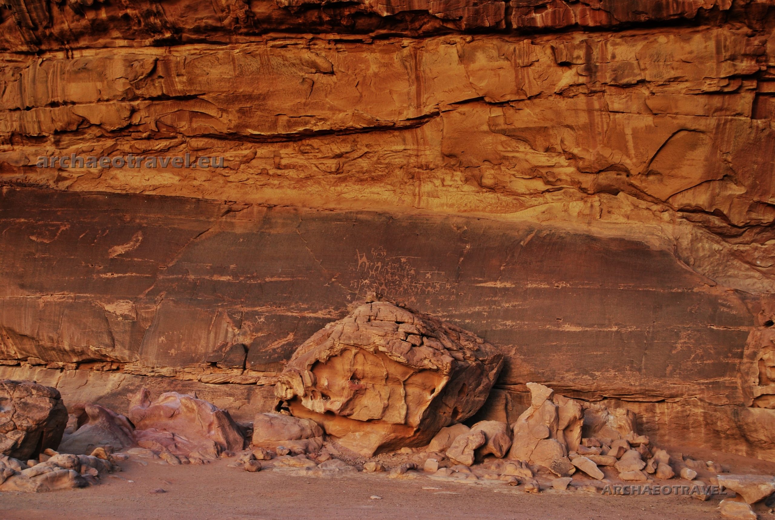
Lycians diligently guarded their freedom independence, trying to resist an outside domination (Bean 1989:20; Miszczak 2009). The region was also the last in Asia Minor to have been incorporated into the Roman Empire, and even then it retained a partial independence in the form of the Lycian League (Miszczak 2009). As such, Lycians had their own language with its peculiar characters, though related to the Hittite and Luwian languages, their own culture, customs and an outstanding style of sepulchral architecture, for which Lycia is interesting today, especially to archaeologists, and tourists making breaks from pleasures offered them by the resorts (Bean 1989:20, 22-23; Miszczak 2009).

At the crossroads of different cultures

By a continuous development of its seaside settlements, ancient Lycia became a major naval power in the region and so it also fully benefited from marine trade (Miszczak 2009). Its coast for centuries had been of great strategic importance for the successive empires ruling over Anatolia, as an important section of the sea route leading from the Aegean Sea eastwards, to the Levant and Egypt (Ibid.). In addition to its military importance, this sea route also greatly contributed to the development of trade and the transmission of civilization achievements (Ibid.). It is worth mentioning that Saint Paul himself came from Greece to Lycia on a merchant ship to spread Christianity in the region (Ibid.). But the history of the Lycian country is much more ancient than the times of Christian apostles, and the land itself is soaked with various legends.

Origins shrouded in mystery

After a Greek tradition recorded by Herodotus (the fifth century BC.), Lycians as a people originated in Crete, where there was a quarrel or fight over the power between two noble brothers, Minos and Sarpedon (Bean 1989:20; Miszczak 2009). Finally, defeated Sarpedon was forced to leave his homeland and together with his supporters, he crossed the sea to Asia Minor and settled down in Lycia, at the time called Milyas, being occupied by Solymians (Bean 1989:20; Miszczak 2009).

SVG Map of ancient Lycia in Turkey. The map of Lycia showing significant ancient cities and some major mountains and rivers. Red dots are mountain peaks, white dots are ancient cities. Prepared by Erp at English Wikipedia (2009). CC BY-SA 3.0. Photo and caption source: “Lycia” (2021). In: Wikipedia. The Free Encyclopedia.

The name Lycia itself, as Herodotus claims, comes from Lycus, son of Pandion the Second, the mythological king of Athens, after whose death, Lycus was driven from his domain by his own brother, Aegeus (the famous Theseus’ father) and eventually found the refuge by joining Sarpedon in Asia Minor, where people took from him the name and became called the Lycians (Bean 1989:20; Miszczak 2009). According to Greek myths, it was the time of the mysterious labyrinth at Knossos, its monstrous inhabitant, Minotaur devouring children, and a conflict of Athens with Crete.

Written tradition

More precise, though unreliable dates of these events are provided by the so-called Parian Chronicle (or Parian Marble), a Greek chronology table covering the years from 1582 to 299 BC., inscribed on a stele found on the island of Paros (the Cyclades) (Bean 1989:20). According to the Greek inscription, it was the early thirteenth century BC., when Lycus reached Asia Minor, whereas the fight between Minos and Sarpedon happened in the latter half of the fifteenth century (Ibid.:20). The given chronology is still confused by the fact there was another Minos at the time of Lycus and Aegeus, and another Sarpedon in the time of the Trojan War, that is to say, in the thirteenth century BC. (Ibid.:20). Yet, the dating from Paros cannot be simply rejected as the names could repeat in history. Moreover, ‘Minos’ may have actually stood not for a name but for a title, as much as ‘pharaoh’ in ancient Egypt (see: Castleden 2000).

Lycia coin, c. 520–470 BC. By Classical Numismatic Group, Inc. (2018). CC BY-SA 3.0. Photo and caption source: “Lycia” (2021). In: Wikipedia. The Free Encyclopedia.

On the other hand, the Hittite records also mention a nation of the Lukka, which is their own name for Lycia (Ibid.:20). They say that Lukka became subject to the Hittite ruler, Suppiluliumas, in the mid-fourteenth century BC. but the lands were continuously rebellious against his domination (Ibid.:20). Nevertheless, it did not discourage Lycian forces to fight later on the side of the Hittites against Egypt in the Battle of Kadesh (1295 BC.) (Miszczak 2009). According to George E. Bean (1989:21), the Hittite records about ‘Lukka’ must have concerned the lands to the west or south-west of the Hittite capital of Hattusa. Also contemporary tablets found in Tell el-Amarna (the mid fourteenth century BC.) records some ‘Lukki’ among the sea riders plundering Cypriot settlements, which would locate them in the region of Caria and Lycia (Bean 1989:20-21; Miszczak 2009). As far as Greek literature is concerned, Homer (the eight century BC.) often mentions the Lycians in the Iliad as allies of Troy (Miszczak 2009; Bean 1989:24). According to the author, the Lycian military contingent was commanded by two famous Lycian warriors and heroes, Sarpedon and Glaucus, whose role in the famous war was not undistinguished. (Miszczak 2009; Bean 1989:24). And it is commonly accepted the Trojan war took place in the thirteenth century BC. (Miszczak 2009; Bean 1989:24).

More evidence provided

In the Hittite accounts, there also appear the names of the cities conquered by the king Suppiluliumas in Lukka in the fourteenth century, namely Dalawa and Hinduwa (Bean 1989:21). Whereas the latter may be identical with Lycian Candyba or Kandyba (district of Kaş), Dalawa may be the same as the Lycian Tlawa (Tlos), located in the valley of Xanthus (Ibid.:21). If such assumptions are correct, then it can be accepted that Lycia had already been established in the fourteenth century, which also acknowledges the information given by the stele of Paros that the Cretans under Sarpedon reached Asia Minor around 1400 BC. (Ibid.:20-21).

The Greek historian Ephorus of Cyme (the furth century BC.) adds that Sarpedon came first to Caria, the region to the west of actual Lycia, and founded the city of Miletus, renamed after a place in Crete (Bean 1989:21). Alternative sources assert that the first city of the future Lycians was actually Idrias (later Stratoniceia), still situated in Caria but further south-eastwards, towards the Peninsula of Tepe (Ibid.:21). If the provided records are reliable, such a settlement would mark the way of Sarpedon southward, from the Aegean Coast to the lands of Lycia (Ibid.:21).

Greek name for a foreign country

Speaking of the name itself, the terms ‘Lycia’ or ‘Lycians’ were used only by Greeks, as much as the Hittite described the same peoples the Lukka, and ancient Egyptians, the Lukki (Bean 1989:20-21; Miszczak 2009). The inhabitants of Lycia, however, called themselves Termilae or Trmmili, and their land, Trmmisa, which is confirmed by their native inscriptions (Bean 1989:22; Miszczak 2009). For this reason, Herodotus’ account that Lycia adopted the name of the Athenian Lycus should be debunked (Bean 1989:22). Possibly, the historian tried to explain the etymology of the name used by the Greeks to describe their neighbours, which was yet adopted, though, slightly modified, by other contemporary civilization. The Greeks had never used their proper name, which actually often has happened throughout history (Ibid.:22). It is enough to provide an example of the people commonly known as Minoans who had created a civilization on Crete; their name was, however, taken by Sir Arthur Evans from the Greek myth mentioning the king of Minos, and has nothing to do with their proper name. Yet, there exist ancient sources describing the same people as Keftiu (Egypt) or Caphtorites (the Hebrew Bible).

Back to legends

The origin of the word Lycia can be rather found in Greek myths, namely in the story of Leto, the goddess from the generation of giants (Titans), who also was the guardian of the entire Lycian people, their homes and tombs (Miszczak 2009).

Lycian dignitary in Achaemenid style, at the Karaburun tomb near Elmalı, Lycia, c. 475 BC. Unknown author (2018). Public domain. Photo and caption source: “Lycia” (2021). In: Wikipedia. The Free Encyclopedia.

According to the legend, the Greek god Zeus fell in love with her but his jealous wife, Hera, chased her husband’s mistress to Asia Minor, exactly to Patara, where the goddess gave birth to the divine twins, Apollo and Artemis (Miszczak 2009). According to alternative story, however, the twins were born later on the island of Delos or Ortygia (near ancient Ephesus in ancient Turkey) (Cartwright 2019). However, yet before giving birth, the persecuted Leto was accompanied on her way through the country by wolves, who guided her across the Xanthos River (Miszczak 2009). To commemorate their help, the goddess called the whole region Lycia, because lycos stands for a wolf in Greek (Ibid.).

More Greek deities

The main deities worshiped in Lycia were therefore Leto and her children, Apollo and Artemis (Miszczak 2009). The most important religious sanctuary of Lycia, dedicated to Leto was located in the Xanthos valley (Ibid.). Some historians believe that the cult of Leto was one of the manifestations of the mother-goddess worship widespread throughout Anatolia, while others believe that the two cults developed in parallel and only later did Leton and the mother-goddess, known in Lycia as Eni Mahanahi, mingled into one divinity (Ibid.).

Dynasts of Lycia: Perikles. Circa 380-360 BC. Photo by Classical Numismatic Group, Inc. (2018). CC BY-SA 3.0. Photo and caption source: “Lycia” (2021). In: Wikipedia. The Free Encyclopedia.

Apollo and Artemis were also widely worshiped throughout the region; the ancient Carian Telmessus (another Telmessus was in Lycia, at modern Fethiye) was known in antiquity for soothsayers who referred to Apollo in their divinations (Miszczak 2009). On the other side, the main centre of the cult of Artemis was Myra, where the daughter of Leto was considered the next incarnation of the mother goddess (Ibid). In addition, the Lycians also worshiped other figures in the Greek pantheon, including Athena, Zeus, Hephaestus, and Ares (Ibid.). An interesting fact, however, are the traces of the cult of Mithras, a deity most likely from Persia, who was worshiped in Olympus by local pirates (Ibid.). Apparently, the Romans inherited the cult of Mithras just from them (Ibid.).

Rebellious nation who loved independence

The history of Lycia is to a large extent the history, mainly of struggles for maintaining independence, fought for with a fluctuating success (Miszczak 2009).

By the sixth century BC, almost the whole western Asia Minor had fallen under the rule of the kings of Lydia, except for the Cilicians and Lycians (Bean 1989:24). Yet in 546 BC., the kingdom of Lydia passed to Persia (Ibid.:24). The Persian invasion under the command of Harpagus, one of the generals of Cyrus the Great, is considered the first attempt at the conquest of Lycia (Bean 1989:24; Miszczak 2009). About 540 BC., the Persians attacked Xanthos, the inhabitants of which made a heroic attempt to resist (Miszczak 2009). Eventually, they committed mass suicide, setting their city on fire, including women and children gathered in the acropolis (Ibid.) Lycian men, on the other hand, fought to the last fighter (Ibid.). Archaeological excavations confirm this tragic story, as a thick layer of ash from this period of history has been unearthed in the city (Ibid.).

Rock-cut tomb at Telmessus (modern Fethiye). Encyclopædia Britannica, 1911 – Encyclopædia Britannica Eleventh Edition, Vol. 2, Page 380. Uploaded in 2012. Public domain. Photo source: “Lycia” (2021). In: Wikipedia. The Free Encyclopedia.

The Persian occupation of Lycia turned out to be quite mild and was reduced to the collection of tribute, leaving the management of the land to the Lycian hands (Bean 1989:24; Miszczak 2009). The period of relative calm was conducive to economic growth, as it is supported by the large number of Lycian coins minted at that time (Bean 1989:24; Miszczak 2009). It was also the time of the creation of the first monumental sepulchral art and the heyday of literature (Miszczak 2009).

Still feeling free, though under occupation

After the Persian wars (480-479 BC.), in which the Lycians contributed on the side of the defeated Persians, the Athenians formed the Delian Confederacy (the maritime league), together with the cities on the western coast of Asia Minor; about 468 BC., the Athenian general Cimon, with a fleet of three hundred ships, drove the Persians out of Lycia and Caria, who were, in turn, to join the Delian Confederacy and pay the tribute to the Athenian league (Bean 1989:24-25; Miszczak 2009). When the Lycians refused, their lands were plundered and the tribute possibly imposed (Bean 1989:25; Miszczak 2009). Nevertheless, when the Athenians became defeated by Sparta in the Peloponnesian War (404 BC.), the Delian Confederacy ended and Lycia again found itself under the Persian domination (Bean 1989:25; Miszczak 2009). Yet, the Lycians did not stop to issue their own coinage or fight for their freedom. Finally, in the early fourth century, they found themselves under the rule of a famous Persian satrap of Caria, Mausolus. Although Lycia resisted under its native dynast Pericles, it became an area under occupation, and military garrisons were located on its territory at strategic points (Bean 1989:25; Miszczak 2009). As a result, the rulers of Caria began to suppress the indigenous Lycian culture and impose in its place the Hellenic-Carian culture (Miszczak 2009).

Alexander the Great in Lycia

Any pretentions to Lycia made by Mausolus’s successors eventually was put to an end by the appearance of Alexander the Great in Asia Minor, who arrived there between 334 and 333 BC. (Bean 1989:25-26; Miszczak 2009). The Lycians had been already tired with the Carian domination and friendly welcomed the Macedonians, even including brave and rebellious Xanthus (Bean 1989:26; Miszczak 2009). After the death of Alexander the Great, in 309 BC., one of his generals and the Pharaoh of Egypt, Ptolemy, took control of Lycia (Bean 1989:26; Miszczak 2009). The Ptolemy dynasty that derived from him lasted in Lycia for over a hundred years (Bean 1989:26; Miszczak 2009).

Silver Drachm of Trajan from Lycia, 98–99 AD, minted during Roman rule. Photo by Ancientcoincollector (2017). CC BY-SA 4.0. Photo and caption source: “Lycia” (2021). In: Wikipedia. The Free Encyclopedia.

Unfortunately, it was the time when Lycia began to lose its linguistic and cultural identity, which was gradually replaced with the Greek one (Bean 1989:26; Miszczak 2009). Greek influences are also very evident in Lycian art from this period of history (Miszczak 2009). An example is the growing popularity of sarcophagi, which began to replace the typical Lycian tombs carved in the rocks (Ibid.). The Lycian League had its beginnings at that time as well (Ibid.).

From hands to hands

In 197 BC. Lycia was passed from the Ptolemies to Antiochus III the Great, a Greek Hellenistic king of the Seleucid Empire (Bean 1989:26; Miszczak 2009). After he was defeated by the Romans in 192 BC., at the battle of Magnesia, Lycia was handed over to the Rhodians, who were in favour of Rome (Bean 1989:26; Miszczak 2009). As a result, the Lycians, rebellious as always, spent the following years fighting for independence and writing petitions to the Roman Senate, which, exhausted by problems with Lycia, finally declared it and Caria free in 167 BC., after which they enjoyed a long time of freedom. Also the Lycian League became more prominent. In the second century BC., the Lycian League acted twice in defence of its independence against usurpers, first in the event of their attempt to gain control over the Xanthos, and then over Tlos (Bean 1989:26-27; Miszczak 2009). Facing such a fierce determination of the Lycians, the Roman Empire left the country untouched during the creation of its province of Asia (129 BC.) (Bean 1989:28; Miszczak 2009).

The growth of the Lycian League

The first century BC. was the period of the greatest splendour and power of the Lycian League, which at that time included as many as thirty-six Lycian city-states on democratic principles (Bean 1989:27-28; Miszczak 2009). During the invasion of the Pontic ruler, Mithridates, on the western part of Asia Minor, in 88 BC., Lycia, unlike other lands that welcomed him as a liberator from Roman occupation, persisted in favour of Rome (Bean 1989:28; Miszczak 2009). Eventually, the Pontic king was defeated in 84 BC. by the Romans, who renewed the guarantees of independence for Lycia as a reward for its loyalty (Bean 1989:28-29; Miszczak 2009). Nevertheless, during the Roman civil war (the first century BC.), Lycia suffered again from the hands of Brutus’ troops till the time it was liberated by the Roman army under Octavian and Mark Antony (Bean 1989:29; Miszczak 2009). The latter granted its independence in 42 BC. and Lycia was the only area of Asia Minor that was not included in the Roman Empire. It was again a time of prosperity and peace for the land (Bean 1989:29; Miszczak 2009).

Saint Nicholas of Myra. Painting by Jaroslav Čermák (1831 – 1878). Uploaded by Galerie Art Praha (2016). Public domain. Photo source: “Saint Nicholas” (2021). In: Wikipedia. The Free Encyclopedia.

The independence of the Lycian Federation ended in 43 AD. during the reign of Emperor Claudius, who joined it to neighbouring Pamphylia as a Roman province (Bean 1989:29; Miszczak 2009). The Lycian freedom was granted back by Nero (54-68 AD.) and had lasted till the reign of Vespasian (69-79AD.) (Bean 1989:29). Moreover, even as a part of the Roman Empire, the Lycian League continued to exist, and the region itself was rich and prosperous (Bean 1989:29; Miszczak 2009). As the Greek geographer, Strabo (the first century AD.) notices, although Rome was still responsible for the matters of war or peace on the terrain of Lycia, its internal affairs were left in the hands of the League (Bean 1989:29; Miszczak 2009). Furthermore, when, in the early fourth century BC., the Emperor Diocletian divided the Lycia and Pamphylia province into two separate lands, the boundary of the former was extended north-westwards and so included Caunus in Caria (modern area of Daylan) and then also the Carian city of Calynda (Bean 1989:29-30; Miszczak 2009). During the Roman Empire, Lycia went through a far-reaching process of romanization, both in the area of its culture and art, and in everyday life (Miszczak 2009).

Santa Clause in Lycia

After two major earthquakes between the second and the third centuries AD, some Lycian cities were turned into ruins (Miszczak 2009). In the third century, Christianity came to the Lycian region and brought significant social and cultural changes (Ibid.). Until the fourth century AD., Christians were persecuted in Lycia, as much as in other parts of the Roman Empire; a few contemporary  Lycian martyrs have gone down into history, together with performed by them miracles (Ibid.). The most famous Christian figure from Lycia is undoubtedly the bishop of the city of Myra, called Nicholas (Ibid.). Yes! Santa Claus comes from Turkey! (Ibid.). He lived in the years 270 – 346 AD. and became well known as a miracle maker, a zealous preacher, converting to Christianity, and a patron of the local population (Ibid.).

And the ancient glory came to an end

The end of Lycian glory was the result of the Plague that blew out between 542 and 745 AD. and increasing acts of piracy in the waters of the Mediterranean Sea; flourishing cities and Lycian ports were abandoned or diminished to the size of villages, which were additionally surrounded by walls protecting them against continuous attacks (Miszczak 2009).

Abandoned Greek city of Kayaköy. Photo by the User Wmck (2011). CC0 1.0 Universal Public Domain. Photo and caption source: “Lycia” (2021). In: Wikipedia. The Free Encyclopedia.

The collapse of the region was also visible by the re-use of the stone from ancient tombs and columns to build city fortifications, as it can be observed in Tlos (Miszczak 2009). Lycia had remained almost uninhabited for several centuries, until the thirteenth century, when the Turks, led by the Teke dynasty, settled on its territory (Miszczak 2009). Hence the name of the Peninsula. The Turks yet stayed away from the coast, which was constantly tormented by pirates who had also established their own settlements there till the eighteenth century (Ibid.). In the early nineteenth century, the rulers of the Ottoman dynasty began to re-populate Lycia, settling in its area the Greek population of the Aegean islands (Ibid.). The few descendants of the ancient Lycians most likely mingled then with the Greek settlers by marriages. After all, they were connected with the Greeks by both, the religion, namely the Eastern Orthodox Church, and a common language, Greek. However, people of the Greek origins were displaced from Lycia again following the peace agreements following the Turkish-Greek war of 1919-1922 (Ibid.). Together with the Greeks, the descendants of Lycia were thus relocated to Greece; just abandoned villages remain after that time on the Tepe Peninsula (Ibid.). The most famous of them is Kayaköy, the so-called Stone Village, which is now a tourist attraction for holidaymakers visiting the region of Fethiye (Ibid.).

When we finally arrived to our hotel from the airport in Antalya, it turned out to be a real heaven, beautifully located in a pine forest, near a narrow path leading to the beach. At last we could take a refuge from insistent rays of the sun and rest from its heat in the shade of wide trees. In the hotel’s open courtyard, a few guests were sitting languidly by the swimming pool, while the waiters were making tables for the upcoming dinner. I sat nearby in the greenery and closed my eyes. Despite my tiredness after the trip, I was looking forward to travelling around the region and discovering monuments of ancient Lycia.

Featured image: Marine of Fethiye, the town situated on the coast of ancient land of Lycian Turkey. Photo by fikret kabay (2017). Photo source: Free images at Pixabay.

By Joanna
Faculties of English Philology, History of Art and Archaeology.
University of Silesia in Katowice, Poland;
Cardinal Stefan Wyszyński University in Warsaw, Poland;
University College Dublin, Ireland.

BIBLIOGRAPHY:

“Fethiye” (2021). In: Wikipedia. The Free Encyclopedia. Available at <https://bit.ly/3bHABY4>. [Accessed on 13th March, 2021].

“Lycia” (2021). In: Wikipedia. The Free Encyclopedia. Available at <https://bit.ly/3dQEJEV>. [Accessed on 10th April, 2021].

“Saint Nicholas” (2021). In: Wikipedia. The Free Encyclopedia. Available at <https://bit.ly/3d7xc5G>. [Accessed on 10th April, 2021].

Bean G. E. (1989). Lycian Turkey. An Archaeological Guide, Vol. 4. London: John Murray Publishers.

Cartwright M. (2019). “Artemis”. In: World History Encyclopedia. Available at <https://bit.ly/3kZVi4y>. [Accessed on 10th March, 2021].

Castleden R. (2000) The Knossos Labyrinth. A New View of the Palace of Minos’ at Knossos. London; New York: Routledge.

Free images at Pixabay. Available at <https://bit.ly/3fTQX0u >. [Accessed on 24th June, 2021].

Miszczak I. (2009). ”Dzieje Licyjczyków”. In: Miszczak I., Miszczak J. Turcja w sandałach. Available at <https://bit.ly/3kVybIh>. [Accessed on 8th March, 2021].

Travel Guidebooks of the Ancients in the Hands of Modern Visitors

The ‘Seven Wonders of the Ancient World’ is the collective concept and canon of knowledge, widely known to the ancient European (Klein 1998:136). The entry into the canon was determined not only by the majesty and uniqueness of a given building, but also by its historical significance and, above all, the myth related to these wonders (Ibid.:136). The latter has always revived ancient monuments and their creators in wandering human minds trying to fully embrace their mystery with a triggered imagination. Such feelings must have accompanied ancient travellers while they were setting off in the unknown to visit the outstanding monuments, many of which had already been said archaic in those times. Even today, when one is faced with the fate of the seven ancient wonders, they unconsciously study the history of the real world from those ages, where such monuments were a real symbol of human striving for perfection and beauty, and of a growing desire to discover and travel far, beyond one’s limits and knowledge (Ibid.:136). But visitors of the ancient wonders had already been guided.

Eternal ancient wonder in Egypt

I was in Egypt on the Plateau of Giza, surrounded by over two millions of squared multi-ton blocks of stone, piling up into three massive pyramids. While standing at the foot of the Pyramid of Khufu, I was looking up at its cone shining in the background of the clouded sky. After a while, I decided to follow some visitors in their way up along the pyramid’s northern wall.

While walking with my sister along the base of the Great Pyramid, I am pointing to the white rows of stones, imitating a fragment of the casing of the Pyramid of Khufu. It was not placed there originally due to its wrong trajectory. Copyright©Archaeotravel.

When I approached its base at the north side, the pyramid’s stones enormously grew in my eyes, which is quite logical when one observes something from close but at the same it was still surprising how large they really turned out to be, especially for someone who had just looked at illustrations of the pyramids depicted from the distance. Simultaneously, I noticed at the bottom of the pyramid a fragment of a flat and white row of stones which were said to be the remains of the outer casing of the pyramid (Grimault, Pooyard 2012). It was not, however, placed there originally, as if its trajectories are stretched up it would hit the opposite blocks just above it (Ibid.). 

Presumably, the fragment of the imitated casing was there just to show how it may have looked like in the past, yet it does not give any valuable insight into an actual construction of the pyramid (Grimault, Pooyard 2012). When I got used to my first impressions, I started climbing up the pyramid, stretching my arms forwards and lifting my legs up to reach the edge of another block above, using each like a successive step of the stairs on my way  up the building. Every block reaches at least to my hips, and some even up to my arms, so climbing up the pyramid definitely involves some physical fitness and strength. Soon my sister joined me and we were both found ourselves just under the original entrance to the pyramid, flanked by angled stones forming a pointed arch above it.

“Man fears time, but time fears the pyramids”

The Great Pyramid, as the Pyramid of Khufu is usually called, has captivated human imagination throughout centuries. Various studies evidently show that there are as many presumptions as false facts about the history and construction of the pyramid (Grimault, Pooyard 2012). As a result, it has remained an everlasting mystery (Ibid.). Actually, it was already so in the times of Herodotus (the fifth century BC.), who, together with other contemporary and later authors unanimously identified it and the two other pyramids of Giza as one of the architectural wonders of the ancient world (see: Zamarovsky 1990:13-64; Klein 1998:141-146).

Soon my sister joined me and we were both found ourselves just under the original entrance to the pyramid, flanked by angled stones forming a pointed arch above it. Copyright©Archaeotravel.

It may have been either due to their massiveness, majesty, age or mystery, or all these aspects together were taken into account, deciding about their high status throughout human history (Zamarovsky 1990:13). The pyramids are also the only wonder of the ancient world that has ever survived and is still enjoyed by the modern world. As such these three pyramids in Egypt  seem to be eternal, which is highlighted by the old and broadly known Arab proverb “Man fears time, but time fears the pyramids.”

As many wonders as their lists

Since the discovery of the pyramids in Egypt by the Hellenized world, much progress had already been made in history by construction of brand-new in comparison to the pyramids but spectacular buildings that arouse such admiration among people to which only natural wonders inspire (Starożytne Cywilizacje 2007:2). There were many authors of the lists of wonders, enumerating these human achievements, and their selection was measured, as it seems, by certain criteria (Ibid.:2).

At some point in history, there were huge discrepancies in various records of the Seven Wonders, which were prepared by independent ancient authors. And although the enumerated wonders were always compiled in the number of seven, each list slightly differed depending on its author. After an archaeologist from the University of Trier (Germany), Michael Pfrommer, If one would sum them all up, they could find ten, if not eleven, or even a dozen ancient wonders described by all the ancients writing on the subject (Klein 1998:137). On the other side, the fact that the successive wonders are listed by various authors in a different order is quite irrelevant as they are all treated on the same scale; It is not a ranking (Zamarovsky 1990:8).

Modern list of the Seven Wonders of the Ancient World

The modern canon of the ancient wonders, known today as the Seven Wonders of the Ancient World is provided by numerous contemporary lexicons and the Internet (Zamarovsky 1990:7). It includes works which, due to their technical or artistic qualities, were admired by the ancients (Ibid.:7). These are: the Great Pyramid of Giza, Hanging Gardens of Babylon, Temple of Artemis at Ephesus, Statue of Zeus at Olympia, Mausoleum at Halicarnassus, Colossus of Rhodes (see: Island of the Sun in Favour of Gods), and the Lighthouse of Alexandria (Ibid.:7).

The Seven Wonders of the Ancient World (from left to right, top to bottom): Great Pyramid of Giza, Hanging Gardens of Babylon, Temple of Artemis, Statue of Zeus at Olympia, Mausoleum at Halicarnassus, Colossus of Rhodes, and the Lighthouse of Alexandria. A collage of The Seven Wonders of the (ancient) world, depicted by sixteenth-century Dutch artist Maarten van Heemskerck. The original uploader was Mark22 at English Wikipedia. – Transferred from en.wikipedia to Commons (2005). Public domain. Photo and caption source: “Seven Wonders of the Ancient World” (2021). In: Wikipedia. The Free Encyclopedia.

Although at first the Seven Wonders of the World, including the pyramids and the hanging gardens of Babylon, were considered must-see attractions on ancient travel routes, they were later considered the greatest structures ever built by man (Starożytne Cywilizacje 2007:1). What was so special about them that they were clearly distinguished by the ancients? Philo of Byzantium answers that question:

For these wonders are the only things which diminish the worth and reputation of other distinguished sights, for, truly, ordinary men may see them in the same way as other sights, but they do not marvel at other sights in the same way. For beauty, like the sun, dazzles by its own brilliance and does not allow one to see the others.

Philo of Byzantium, “On the Seven Wonders of the World”. A free translation by Jean Blackwood of the text of De Septem Orbis Spectaculis as it appears in Aelianus Praenestinus, compiled by Rudolf Hercher and published in 1858. In: Rogers Pearse. Thoughts on Antiquity, Patristics, Information Access and More.

Though tarnished by time, the Pyramids of Giza have fortunately survived to our times. But what about those wonders that have already gone? Michael Pfrommer says that ancient travellers describing the wonders were surely convinced of the durability of these places and monuments (Klein 1998:137). Often, however, of the architectural wonders people consider to be eternal, there is absolutely nothing left behind after all (Ibid.:137). Or at least very little. The garden on the terraces of Babylon and two statues, one of Zeus made of chryselephantine and the other of Helios made of bronze, have disappeared forever. Of the burial site of Mausolus of Caria, the mighty temple of Artemis in Ephesus and the Lighthouse of Pharos, there are left only few remains, of which some are scattered in museums around the world.

The real authorship of the list

Little is known today about an ancient Greek poet, named Antipater of Sidon, who lived in the second half of the second century BC. (Klein 1998:147).  His character unfortunately disappears now in the fog of history (Ibid.:147). Still it is believed that it was him who compiled the first completely preserved list of wonders of the ancient world in the second century BC. and perhaps he had seen them all himself during his long and distant journeys (Ibid.:147). It was a list of architectural wonders that would surely have been labelled today as ‘must see monuments’, and therefore his work can be regarded as the first travel guidebook for contemporary adventurers and travellers.

Assyrian wall relief showing Hanging Gardens of Babylon … in Assyrian Nineveh. Photo by Noah Wiener (2015). Public domain. Photo and caption source: “Hanging Gardens of Babylon” (2021). In: Wikipedia. The Free Encyclopedia.

Initially, the creation of the list was mistakenly attributed to a certain Philo of Byzantium, a mathematician who probably lived in the second century BC. and was wrongly said to have been the author of a treatise titled On the Seven Wonders of the World (Klein 1998:147; Zamarovsky 1990:7). Such information was first disseminated by the first modern translator of the book by Philo of Byzantium, a French D.S. Boessius, who in 1640 discovered the Greek original in the Vatican Library and translated it into Latin as De septem mundi miraculis (Zamarovsky 1990:7-8). Such mistakes once in writing are often copied in the literature, and the wrong information about the authorship had been then unintentionally replicated and so circulated from one work to another (Ibid.:7-8).

Mausoleum at Halicarnassus, as imagined, at the Bodrum Museum of Underwater Archaeology. Photo by Jona Lendering – Livius.org Provided under CC0 1.0 Universal license (notice under the photograph in the description page of the photograph). Retouched by the uploader (2018). CC0. Photo and caption source: “Mausoleum at Halicarnassus” (2021). In: Wikipedia. The Free Encyclopedia.

The matter was clarified only by a Swiss classical scholar, Johann Caspar von Orelli, who published Philo’s book in print for the first time in 1816 and it finally turned out that there were actually two different ‘Philos’, who had initially been confused (Klein 1998:147; Zamarovsky 1990:7-8). The real author of the work is also Philo of Byzantium but he lived much later than his namesake, probably in the third or fourth century AD. (Zamarovsky 1990:7-8). The records of him are fragmented almost as much as those of the ancient Philo (Ibid.:7). It is only known for certain that Philo from our era is an actual author of the book On the Seven Wonders of the World (Klein 1998:147; Zamarovsky 1990:7-8). Additionally, from this work one can also learn that he had not seen a single monument of the architectural wonders he described in his work (Zamarovsky 1990:7-8). So he depicted them just with the eyes of his imagination, inspired only by what he knew from second-hand accounts (Ibid.:7-8). To justify such practice, it can be added that many current authors, including myself, do the same today, when it Is not possible to take a trip and see a given site personally (Ibid.:8). Sometimes, it is an education that relieves some authors of the necessity of traveling, and things worthy of their attention they learn just from books without even leaving home (Ibid.:8).

The fame of the Temple of Artemis was known in the Renaissance, as demonstrated in this imagined portrayal of the temple in a sixteenth-century hand-colored engraving by Martin Heemskerck. Photo by Philip Galle – From en:wikipedia. Public domain. Photo and caption source: “Temple of Artemis” (2021). In: Wikipedia. The Free Encyclopedia.

In any case, Antipater of Sidon has regained his right to be named the first author of the list of the Seven Wonders of the World that he described in a poem written about 140 BC. (Starożytne Cywilizacje 2007:3; Klein 1998:147-150; “Antipater of Sidon” 2021). Accordingly, his name is now placed just along with Philo of Byzantium, Strabo, Herodotus and Diodoros of Sicily, who were all involved in writing on the subject (“Antipater of Sidon” 2021).

Travel fever in ancient times

Today there is a common view that real travellers no longer exist and a noble phenomenon of traveling has already been replaced by the less noble term of mass tourism (Lachowicz 2015). As a result, white spots on the travel map of the world are slowly disappearing, being replaced by tourist folders to distant, so far inaccessible places on the planet (Ibid.). The epoch of pioneering unknown routes and travelling over hidden treasures has unfortunately ended with the last dare-devil explorers at the turn of the twentieth century. Yet, I believe that a human desire for an adventure is still alive in the hearts of curious modern travellers and there is somewhere not a single wonder still waiting for its discoverer.

The Colossus as imagined in a 16th-century engraving by Martin Heemskerck, part of his series of the Seven Wonders of the World. By Marten van Heemskerck (1498-1574). Uploaded in 2014. Public domain. Colours intensified. Photo source: “Colossus of Rhodes”(2020) Wikipedia, the Free Encyclopedia.

Simultaneously, I can imagine all these ancient visitors coming to see the seven wonders, directed just by guidelines of contemporary authors, who had visited the sites first. Surely, a journey along the track of the seven wonders must have taken many years or even a lifetime to be accomplished, providing that one was taking a journey with intention to see all the monuments on the list. Alternatively, ancient travellers could  have chosen their desired destinations at random, according to their own bucket list, as it is practised today. I can bet that many modern travellers, if they only had a chance to live in those times, would have travelled long distances to visit the wonders at their height. Nowadays, there are, after all, lots of people who are addicted to travelling and they are only fully alive on the way, even at their personal cost. On the other side, although such an ancient journey made one’s dreams come true, it must simultaneously have been a real challenge to contemporary travellers.

Everyone knows of the renowned Seven Wonders of the World, but few have set eyes on them, for, in order to do so you have to arrange a long journey to the land of the Persians on the far side of the Euphrates; you have to visit Egypt; you must then change direction and go to Elis in Greece. Then you must see Halikarnassos, a city-state in Caria, and Ephesos in Ionia, and you have to sail to Rhodes, so that, being exhausted by lengthy wanderings over the Earth’s surface, and growing tired from the effort of these journeys, you finally fulfil your heart’s desire only when life is ebbing away, leaving you weak through the weight of years.

Philo of Byzantium, “On the Seven Wonders of the World“. A free translation by Jean Blackwood of the text of De Septem Orbis Spectaculis as it appears in Aelianus Praenestinus, compiled by Rudolf Hercher and published in 1858. In: Rogers Pearse. Thoughts on Antiquity, Patristics, Information Access and More.

An outstanding ancient travel journalist, Antipater of Sidon must also have possessed quite a bit of courage and endurance to visit all the wonders he later described (Klein 1998:147). Certainly, in antiquity there were people such as the author, who were ready to endure the hardships of dangerous journeys, especially in the period after the conquests of Alexander the Great, when the world known at that time expanded considerably in the fourth century BC., including the lands of Babylon, Persia and Egypt (Klein 1998:147; Starożytne Cywilizacje 2007:1).

Reconstruction of the Oikoumene (inhabited world), an ancient map based on Herodotus’ description of the world, circa 450 BC. Photo by Bibi Saint-Pol (2006), based on the GIF by Marco Prins and Jona Lendering from www.livius.org. Public domain. Photo source: “Atlantis” (2020). In: Wikipedia. The Free Encyclopedia.

Those ancient travellers took risks that modern tourists have not even dreamed of (Klein 1998:147). To imagine any struggles they may have encountered on their way, it is enough to read various descriptions of a number of journeys done by mythological heroes, such as Hercules, Theseus or Odysseus, who on their way met hosts of various monsters, robbers, giants, including cyclops, or mermaids, and their journey lasted for years, additionally experienced by the violent vagaries of nature and the whims of the gods deciding about travellers’ fate (Ibid.:147,149). All these stories testified to the dangers that the ancient traveller had to reckon with (Ibid.:147,149). How mysterious and dangerous but, at the same time, fascinating the world must have been for them (Ibid.:147,149). For some, travel meant fullness of life, but also death (Ibid.:147). Nevertheless, the ancient traveller, though exposed to many dangers, trusted in both, their lucky star and the smile of gods (Ibid.:147,149). They were also able to be delighted with what they had seen, as can be noticed in the verses recorded by Antipater of Sidon, returning from his expedition (Ibid.:147,149).

I have set eyes on the wall of lofty Babylon on which is a road for chariots, and the statue of Zeus by the Alpheus, and the hanging gardens, and the Colossus of the Sun, and the huge labour of the high pyramids, and the vast tomb of Mausolus; but when I saw the house of Artemis that mounted to the clouds, those other marvels lost their brilliancy, and I said, ‘Lo, apart from Olympus, the Sun never looked on aught so grand.

Antipater, “Greek Anthology IX. 58“. In: “Antipater of Sidon” (2021). In: Wikipedia. The Free Encyclopedia.

The walls of Babylon instead of the Lighthouse of Pharos

It is noteworthy that Antipater mentions the walls of Babylon in his work, an object that does not appear in later lists (Klein 1998:149). And he omits the Pharos Lighthouse (Ibid.:149). This may be a decisive clue saying that Antipater used a prototype for his own work as the Lighthouse had already been there when the author lived, that is to say in the second century BC. (Ibid.:149-150). Babylon’s walls made of fired bricks were on everyone’s lips in the fourth and third centuries BC, while the Pharos Lighthouse had not been built until around 280 BC. (Ibid.:149-150). On the other hand, the original list cannot be much older than the Alexandrian Tower, since the author mentions the Colossus of Rhodes (Ibid.:150). This statue was built less than twelve years before the Lighthouse was built (Ibid.:150). Thus, the date of the creation of the oldest list of wonders of the world can be placed between 292 and 280 BC. (Ibid.:150).  

A mosaic depicting the Pharos of Alexandria, (labeled “Ο ΦΑΡΟϹ”), from Olbia, Libya c. 4th century AD. Mosaic Lighthouse of Alexandria: was found in the Qasr Libya in Libya, which was known by several names including history and Olbia Theodorias, This is a painting that was left over to show the form of lighthouse after the quake, which destroyed the lighthouse. Uploaded by Qasr Libya Museum – Qasr Libya Museum (2010). Public domain. Photo and caption source: “Lighthouse of Alexandria” (2021). In: Wikipedia. The Free Encyclopedia.

Accordingly, some scholars claim that in the third century BC., a Greek scholar of the Great Library of Alexandria, Callimachus of the Cyrene, Libya, was probably the first to have compiled the very first list of marvellous buildings (Starożytne Cywilizacje 2007:3). Presumably, he placed on it the greatest achievements of contemporary Greece, taking into account their size, materials used, technical solutions and innovation of their creators (Ibid.:3). His list, however, has not survived to our times (Ibid.:3).

As it is seen, while searching for any historical traces of the first description of the ancient wonders, one comes across many complex issues, in which they move like in a maze of assumptions and questions (Klein 1998:150). Generally, taking into account the above, Antipater of Sidon, who was born a hundred years later than the estimated above dates, may have used an earlier source, treating it as a travel guidebook in his journey and at the same time the source of his own work (Klein 1998:150; Starożytne Cywilizacje 2007:3). Is it possible that Antipater had access to Callimachus’ work, and so compiled his list a century later? (Klein 1998:150; Starożytne Cywilizacje 2007:3). Or maybe his trip, which he described, took place only in his imagination …? (Klein 1998:150; Starożytne Cywilizacje). Or for the author, the walls of Babylon he had visited deserved more attention and privilege to be called one of the wonders than the Lighthouse itself; accordingly, the latter did not appear on his list, which was created in the second century BC.

Map of Europe according to Strabo. Photo by Fphilibert – Picture from polish Wikipedia (2005). Public domain. Photo and caption source: “Strabon” (2020). In: Wikipedia. Wolna Encyklopedia.

The truth, however, remains unknown.

By Joanna
Faculties of English Philology, History of Art and Archaeology.
University of Silesia in Katowice, Poland;
Cardinal Stefan Wyszyński University in Warsaw, Poland;
University College Dublin, Ireland.

BIBLIOGRAPHY:

“Atlantis” (2021). In: Wikipedia. The Free Encyclopedia. Available at <https://bit.ly/3e6BQ4f>. [Accessed on 1st May, 2021].

“Colossus of Rhodes”(2020) Wikipedia, the Free Encyclopedia. Available at <https://bit.ly/3aUSEJm>. [Accessed on 1st May, 2021].

“Strabon” (2020). In: Wikipedia. Wolna Encyklopedia. Available at <https://bit.ly/3xGsAeY>. [Accessed on 1st May, 2021].

“Antipater of Sidon” (2021). In: Wikipedia. The Free Encyclopedia. Available at <https://bit.ly/3gT4yaH>. [Accessed on 1st May, 2021].

“Hanging Gardens of Babylon” (2021). In: Wikipedia. The Free Encyclopedia. Available at <https://bit.ly/3vArf7q>. [Accessed on 1st May, 2021].

“Lighthouse of Alexandria” (2021). In: Wikipedia. The Free Encyclopedia. Available at <https://bit.ly/3gOPv1E>. [Accessed on 1st May, 2021].

“Mausoleum at Halicarnassus” (2021). In: Wikipedia. The Free Encyclopedia. Available at <https://bit.ly/3udct6l>. [Accessed on 1st May, 2021].

“Ryszard Kapuściński” (2021). In: Wikipedia. The Free Encyclopedia. Available at <https://bit.ly/3gWALxD>. [Accessed on 1st May, 2021].

“Seven Wonders of the Ancient World” (2021). In: Wikipedia. The Free Encyclopedia. Available at <https://bit.ly/3tar9BK>. [Accessed on 1st May, 2021].

“Temple of Artemis” (2021). In: Wikipedia. The Free Encyclopedia. Available at <https://bit.ly/3eankZf>. [Accessed on 1st May, 2021].

Grimault, J. Pooyard P. (2012). The Revelation of the Pyramids. Ekwanim Production &Wild Bunch.

Klein G. (1998). ”Siedem Cudów Świata”. In: Sfinks. Tajemnice Historii, vol. 3., [Sphinx. Geheimnisse der Geschichte. Von Ramsez II bis zum Ersten Kaiser von China], pp. 134-178. Zimmerer K. trans., Huf H-C. ed. Warszawa: Świat Książki.

Lachowicz J. (2015). “Czym różni się turysta od podróżnika?”. In: National Geographic Polska. Available at <https://bit.ly/3aUZ6jH>. [Accessed on 1st May, 2021].

Pearse R. (2019). “Philo of Byzantium, On the Seven Wonders of the World: an English translation and some notes”. A free translation by Jean Blackwood of the text of De Septem Orbis Spectaculis as it appears in Aelianus Praenestinus compiled by Rudolf Hercher and published in 1858. In: Rogers Pearse. Thoughts on Antiquity, Patristics, Information Access and More. Available at <https://bit.ly/2QLV4TR>. [Accessed on 1st May, 2021].

Starożytne Cywilizacje (2007). “Siedem cudów świata. Starożytne wspaniałości.” In: Starożytne Cywilizacje. MMX International Masters Publishers AB.

Zamarovsky V. (1990). Tropami Siedmiu Cudów Świata, [Za siedmi divmi svĕta]. Godlewski P. trans. Katowice: Wydawnictwo „Śląsk”.

Imagery of the Valley of the Moon in Jordan

In the late afternoon, we found ourselves on the threshold of Wadi Rum. Known also as the Valley of the Moon (“Wadi Rum” 2020), this magic land is located in the southern part of Jordan, close to the border with Saudi Arabia, and about forty kilometres east of Aqaba (Chabińska-Ilchanka et al. 2015:265).

Across the desert … Copyright©Archaeotravel.

Lawrence from Arabia

Today, Wadi Rum is a home to Jordan Bedouins, who are Arab semi-nomadic people inviting visitors to their fairy-tale kingdom. One of the most famous guests to Wadi Rum was undoubtedly T.E. Lawrence (1888–1935), also known as Lawrence from Arabia (Biography 2014-2015). He was a British military officer and archaeologist greatly involved in Middle Eastern affairs and in the Great Arab Revolt (Ibid.). In the years 1917-1918, Lawrence travelled through Wadi Rum several times describing his enchantment at the entrance into the Valley as follows (“Wadi Rum” 2020):

The portrait of T.E. Lawrence (1888–1935), in Wadi Rum. Also known as Lawrence from Arabia advocated for Arabs’ independence. Copyright©Archaeotravel.

“The hills on the right grew taller and sharper, a fair counterpart of the other side which straightened itself to one massive rampart of redness. They drew together until only two miles divided them: and then, towering gradually till their parallel parapets must have been a thousand feet above us, ran forward in an avenue for miles. The crags were capped in nests of domes, less hotly red than then body of the hill; rather grey and shallow. They gave the finishing semblance of Byzantine architecture to this irresistible place: this processional way greater than imagination.”

Lawrence, T.E. 1935:351

Iram of the pillars

We climbed onto one of the three off-road cars and started our journey through sandy and rocky oranges of the desert. The sun was still hanging high but the night falls there in the nick of time. It automatically brings a sudden cold that replaces the daytime sun heat. In such conditions warm clothes are a must.

In its fascinating past, Wadi Rum must have been inhabited by many various cultures whose distinctive traces are still visible today (“Wadi Rum” 2020).

Piles of stones may hold various meanings. Copyright©Archaeotravel.

It is likely that it receives its name from Iram of the pillars, which is usually described as a lost city, region or tribe mentioned in the Quran (Ibid.). Cut into the sandstone and granite rock, it includes an area of ​​approximately seventy-four thousand hectares of amazing landscape, distinguished by extraordinary natural and cultural value (Chabińska-Ilchanka et al. 2015:265; “Wadi Rum” 2020). The natural environment consists mainly of the typical though stunning desert landscape with a varied topography (Chabińska-Ilchanka et al. 2015:265). There are sandy plains, cliffs, gorges and even caves and rocky landslides (Ibid.:265). An interesting diversification of that landscape are natural rock formations in the form of arches, bridges and arcades (Ibid.:265).

Petroglyphs

Within this area, groups of pre-historic petroglyphs have been found at several sites (Chabińska-Ilchanka et al. 2015:265). The rock drawings most likely come from twelve thousand years ago and prove the existence of settlement in this desert area since prehistoric times (Ibid.:265). Due to cultural landscape and its natural values, in 2011 the protected area of ​​Wadi Rum was entered on the UNESCO World Cultural and Natural Heritage List (Ibid.:265).

Unidentified animal-like creature on the reddish rock. Copyright©Archaeotravel.

Among the rock carvings that were found in Wadi Rum, there are twenty-five thousand figurative representations and twenty thousand characteristic signs looking like inscriptions that could constitute the first attempts to create a writing (Chabińska-Ilchanka et al. 2015:265; Mohammad 2015). The former usually represent people and animals, whereas among the latter, there are North-Arabian scripts: Nabatean, Islamic (Kufic), Arabic and mostly the so-called Thamudic inscriptions (Chabińska-Ilchanka et al. 2015:265; Mohammad 2015; “Wadi Rum” 2020; “Thamudic” 2020).

The Thamud

The Thamud belonged to ancient Arabian tribes occupying the north-western Arabian peninsula between the late eighth century BC and the fourth century AD (“Thamud” 2020). “They are mentioned in contemporary Mesopotamian, Classical, and Arabian sources” (Ibid.). It does not mean, however, all the petroglyphs from Wadi Rum were made by that tribe (“Thamud” 2020; “Thamudic” 2020). Actually, the name Thamudic was invented by nineteenth-century scholars for major part of inscriptions covering a huge area from Syria to Yemen (“Thamudic” 2020). “[Such inscriptions belong to a large group of] Ancient North Arabian (ANA) alphabets which have not yet been properly studied” (Ibid.).

The Nabatean

Many petroglyphs from Wadi Rum, however, are ascribed to Nabateans, an ancient nomadic Arab people who emerged between the fourth and second century BC and held their independence till the annexation of their territory to the Roman Empire in 106 AD (“Nabataeans” 2020). Nabateans are also said to be creators of Petra and although they surely inhabited the site, there is much doubt regarding the original builders of the city. It is, however, another story …

In tranquil and shaded Ain Shalaaleh, on the south side of Wadi Rum, there is the head of a Nabatean rock-cut aqueduct, which is close to Rum village and the remains of the Nabatean temple (Mohammad, “Confusion (….)” 2015).

Typical images of Wadi Rum: animals, humans, enigmatic symbols and inscriptions. Copyright©Archaeotravel.

Lawrence wrote that “[on] the rock-bulge above were clear-cut Nabathaean inscriptions, and a sunk panel incised with a monogram or symbol. Around and about were Arab scratches, including tribe-marks, some of which were witnesses of forgotten migrations: but my attention was only for the splashing of water in a crevice under the shadow of the overhanging rock. I looked in to see the spout, a little thinner than my wrist, jetting out firmly from a fissure in the roof, and falling with that clean sound into a shallow, frothing pool, behind the step which served as an entrance. Thick ferns and grasses of the finest green made it a paradise just five feet square.” (Lawrence 1935, p.355).

Images for communication

“Petroglyphs are images created by removing part of a rock’s surface by incising, pecking, carving, and abrading with something like a stone chisel. Inscriptions are characters [created just] in the same way as petroglyphs. Most petroglyphs [in Wadi Rum] were made on cliff faces, [large] rocks, and boulders” (Mohammad 2015).

In the process of deciphering … Copyright©Archaeotravel.

The content of the petroglyphs and other artifacts found in the area are a source of knowledge about the social change and lifestyle of prehistoric desert tribes in the Arabian Peninsula (Chabińska-Ilchanka et al. 2015:265). “The illustrations of people show human figures holding bows and arrows” (Mohammad 2015). By their side, there is a large number of drawings representing animals, such as camels, ibexes, and horses (Ibid.). “[Alongside] all these figures are [enigmatic] symbols like lines and circles. Experts [assume] that they are instructions and messages left by [prehistoric] people [to communicate]. Some of them [may be] about giving directions to find hidden springs, [whereas others] about updating each other on things like who visited the area last. Altogether, these engravings [are believed] to provide an insight into the development of human thought [as] a pattern of pastoral, agricultural, and urban human activity” (Ibid.).

Scorpions were already asleep

We got off the car and approached one of the multiplied rocks. Its reddish surface was carved with intriguing images.

Are there any other hidden petroglyphs? Copyright©Archaeotravel.

At first sight I could discern some animal figures, mostly camels. Yet some were rather difficult to guess. Whereas some camels were depicted in movement with funny forked tails, others were standing still and the one had an inscription inside its body. The biggest one with its long neck looked like a giraffe. Only its single visible hump indicated that it was a dromedary after all. There were also a few primitively drawn human figures with outspread arms and legs, who may stand for Neolithic members of a nomadic tribe. Those were quite similar to Neolithic human representations from northern Africa. Most intriguing, however, were strange symbols depicted around the recognized characters – one looked like a mountain peak – and inscriptions accompanying the whole scene. ‘I wish I could stay here longer and make drawings’, I thought while taking a thousand of pictures. Pushed by curiosity and in search of further images, I slipped under the rock ledge above the carvings. After a while I found there some traces of petroglyphs but mostly fragmented inscriptions. ‘You are a peeping type of a person’, said our Bedouin guide smiling. ‘It’s good that scorpions are already asleep’, he added.

It was pitch-dark when we finally reached back our camp. The electrical lamps illuminated a row of large tents waiting for tired visitors. We had just arrived to Jordan and Wadi Rum turned out to be our gate to its treasures.

Featured image: Wadi Run – petroglyphs. Copyright©Archaeotravel.

By Joanna
Faculty of History of Art and Archaeology
Cardinal Stefan Wyszyński University in Warsaw, Poland
University College Dublin, Ireland

BIBLIOGRAPHY:

“Nabataeans” (2020) Wikipedia. The Free Encyclopedia. Available at <https://bit.ly/3nNAs8u>. [Accessed on 22nd November, 2020].

“Thamud” (2020) Wikipedia. The Free Encyclopedia. Available at <https://bit.ly/3lWe8cf>. [Accessed on 22nd November, 2020].

“Thamudic” (2020) Wikipedia. The Free Encyclopedia. Available at <https://bit.ly/3950pfL>. [Accessed on 22nd November, 2020].

“Wadi Rum” (2020) Wikipedia. The Free Encyclopedia. Available at <https://bit.ly/3kS4OoI>. [Accessed on 22nd November, 2020].

Biography (2014-2015) “T.E. Lawrence”. In: Biography.com. Available at <https://bit.ly/3kOf69e>. [Accessed on 22nd November, 2020].

Chabińska-Ilchanka, E., Dylewska K., Horecka K., Jaskulski M., Kastelik M. M., Łatka M., Ressel E., Willman A., Żywczak K. (2015) Niezwykłe miejsca świata. Warszawa: Wydawnictwo SBM Sp. zo.o.

Lawrence, T.E. (1935) Seven Pillars of Wisdom. Garden City: Doubleday, Doran & Company, Inc.

Mohammad, F. (2015) “Confusion about the Real Lawrence Spring Cleared”. In: Wadi Rum. Nomads. Available at <https://bit.ly/2J58ZA0>. [Accessed on 22nd November, 2020].

Mohammad, F. (2015) “The Petroglyphs and Inscriptions of Wadi Rum”. In: Wadi Rum. Nomads. Available at <https://bit.ly/36VBEjz>. [Accessed on 22nd November, 2020].

Image of the Goddess: between Matriarchy and Patriarchy

On the threshold of the Neolithic, the hunter slowly turns into a farmer and breeder (Jabłońska 2010; Burda, Halczak, Józefiak, Szymczak 2002:32). This is a special period in the development of the matriarchal system (Ibid.). The forces of nature continue to play a major role in human life, yet the new lifestyle changes its spiritual approach (Ibid.). Moon worship is replaced by solar cult but it is still closely related to female aspects and so responsible for factors influencing land fertility and annual harvests, which are highly significant to Neolithic society (Ibid.). The cycle process and persistence of nature flows from its divine matrix (Ibid.). Mother Earth supports life, is responsible for death, but also guarantees rebirth (Ibid.).

Neolithic face of Magna Mater

In the Paleolithic, the dark, hidden uterus corresponded to cave sanctuaries (see Figurines of the Stone Age: Miniature Great Mother of the Paleolithic), and in the Neolithic it was identified with the earth itself – the eternal parent (Jabłońska 2010). Magna Mater managed vegetation, nature, and her fertility originated in the ground which, as the humans observed, gave birth to all forms of life without interruption (Ibid.). The Neolithic likewise saw a similarity between the growth of humans and plants, with the cycle of birth, life, death and rebirth (Ibid.).

Seated “goddess” of Çatalhöyük, Museum of Anatolian Civilizations, Ankara, Turkey (the sixth millennium BC). Neolithic Magna Mater was usually enthroned and flanked by two animals. In this representation, she is giving birth to a child. Copyright©Archaeotravel.

While naturalistic cave art fades away with the end of the Paleolithic world of the hunter-gatherer, the image of the Mother-Goddess stubbornly repeats the well-established pattern: exaggeratedly lush shapes with lack of care for facial features, arms and legs, as if the essence of femininity was limited to the heaviness of a figure distorted by motherhood (Nougier 1898:39). Such domestic female figurines still had a right to exist, as does life that awoke in Mother Earth’s womb (Members of Staff at the Museum of Anatolian Civilizations 2006:25-48).

Goddess in the first cities

In the Neolithic Age, when the first cities were sprouting, goddess worship was not only common, but it clearly flourished and gained importance (Members of Staff at the Museum of Anatolian Civilizations 2006:25-48). This is evidenced by the finds of numerous figurines of the goddess – mother in the houses of the first urban settlements, such as the Anatolian Çatalhöyük or Hacilar (Ibid.:25-48). The place where religious rituals were performed was apparently a part of the house adapted for these purposes, most often decorated with geometric patterns and heads of bulls, animals dedicated to the goddess (Ibid.:25-48). In the museum reconstruction of the home sanctuary in Çatalhöyük, a plaster relief of the Mother Goddess is displayed, surrounded by bull heads (Ibid.:25-48). The local statuettes were most often carved in stone, made of burnt clay, and later also of terracotta, and although they resembled the Great Mother of the Paleolithic, the Neolithic female figurines were distinguished by the multitude of representations (Ibid.:25-48).

Restoration of a typical interior of Catal Höyük dwelling with the bulls’ heads – a possible symbol of the Neolithic goddess. The Museum of Anatolian Civilizations, Ankara, Turkey. Copyright©Archaeotravel.

They were depicted in a standing or sitting position; once they resembled a young girl, another time a giving birth mother, and finally an old woman (Members of Staff at the Museum of Anatolian Civilizations 2006:25-48, 183; Żak-Bucholc 2005). These three views allude to the three aspects of the goddess and at the same time to the three stages of a woman’s life; the Virgin is the first image of the triple goddess, the second is the Mother, and the third is the Old Woman (Ibid.). In this way, the goddess figure makers probably wanted to emphasize the sacred cycle of life and death (Ibid.). Since the Neolithic times, various forms of the image of the Mother-Goddess had slowly emerged, and iconographic figurative groups were formed (Ibid.). In this way, the original idea had been subject to further modifications over time, which took place within the great ancient cultures (Ibid.).

Mother enthroned

One of the famous iconographic groups is the enthroned Goddess and Lady of the Animals (Żak-Bucholc 2005). The oldest example of such a divine position is represented by a figure found in Çatalhöyük (Żak-Bucholc 2005; Members of Staff at the Museum of Anatolian Civilizations 2006:25-33). Now preserved at the Museum of Anatolian Civilizations in Ankara, the Mother Goddess dates from the sixth millennium BC (Ibid.). As the one of the most important artifacts, she is enthroned among the rich collections of other Neolithic female figurines in the museum (Ibid.). Like the Palaeolithic Venus, the image of the Çatalhöyük mother goddess is characterized by generous body shapes and slightly delineated facial features, with a high forehead, headgear or single roller hairstyle (Ibid.). The heads of the two leopards are flanking her throne (Ibid.). Between the legs of the figure, at the level of the throne, a small, oval form is visible (Ibid.). Possibly, it is the baby’s head that emerges from the mother’s womb (Ibid.). Accordingly, the clay figurine of the goddess represents a woman giving birth (Ibid.). The second of the three stages of a woman’s life – motherhood – refers directly to the cult of life, fertility, and the very idea of ​​Magna Mater (Ibid.).

Seated Woman of Çatalhöyük, Museum of Anatolian Civilizations, Ankara, Turkey”. In: “Seated Woman of Çatalhöyük. Photo by Dilmen N. (2012). CC BY-SA 3.0. Source: Wikipedia. The Free Encyclopedia.

Another figurine illustrating motherhood is a terracotta statue of a mother with a child in her arms, which also dates back to the sixth millennium and comes from the Hacilar area (Żak-Bucholc 2005; Members of Staff at the Museum of Anatolian Civilizations 2006:25-33). Unfortunately, the baby’s head has not survived to our times (Ibid.). The mother was caught in a sitting position; her posture seems very natural and relaxed, as if it came from the joy of having a baby and holding it in her arms (Ibid.).

Lady of the Animals

The image of the goddess sitting on a throne, or standing upright – the position similar to a pole or column – and surrounded on both sides by sacred animals, is probably a prototype of the representations of the later Animal Goddess – Artemis of Ephesus (Żak-Bucholc 2005; Members of Staff at the Museum of Anatolian Civilizations 2006:25-33). In the Neolithic and Bronze Age, votive objects of a zoomorphic character were usually offered to the goddess; these were most often terracotta vessels, statuettes or frescoes depicting leopards, bulls, wild boars, deer, bears and birds (Ibid.).

Goddess on the Mountain

Yet another reference to the Throne of the Lady of Animals theme can be a plastic depiction of a female figure standing on a small pedestal or a hill, with animals, often lions facing her (Żak-Bucholc 2005).

Throne Room in Knossos (Minoans; the Bronze Age). If the Throne was once occupied by a Priestess, it may have been symbolically meant for a mountain peak, which was the seat of the goddess. Copyright©Archaeotravel.

This iconographic group is known as the Mountain Goddess, and the mountain the goddess stands on can be interpreted as a form of a throne (Żak-Bucholc 2005). Often the embodiment of the goddess was the Throne itself, flanked by animals, which is best depicted in the Throne Room of the Minoan Knossos – assuming, however, that the throne belonged not to the king Minos but to a priestess (Ibid.; see Lady of the Labyrinth).

Female column flanked by beasts

Another form of representing a goddess is a column or pillar, most often with a pair of lions (lioness) on either side of it. Such depictions of a deity are typical of the Hittites (Żak-Bucholc 2005). One of the best examples of the representation of the Goddess as a column, however, is the Lion Gate in Mycenae (Ibid.).

Detail photo of the Lion Gate in Mycenae, Argolis, Greece. The goddess is played by a column flanked by two lions/lioness. Photo by Van der Crabben J. (2012). Source: Ancient History Encyclopedia.

In Minoan art, the most typical is in turn the image of the Goddess as a woman holding writhing serpents in both hands (Żak-Bucholc 2005). Regardless of the accompanying animals of Magna Mater, the iconographic group described above shows the Lady ruling over the forces of Nature, who is therefore responsible for maintaining harmony in the Universe (Ibid.)

Woman supporting her breasts

Another form of depicting a goddess is a woman supporting her breasts, precisely a female figure with her hands under her breasts or crossed on the breasts, or with her hands supporting them (Żak-Bucholc 2003; 2005).

Twin goddess supporting breasts. Çatalhöyük, 6000-5500 BC. Museum of Anatolian Civilizations, Ankara. Photo: Zde (1999). Source: Wikimedia Commons.

Such representations date back to the Neolithic age and appear in Anatolia, Mesopotamia and Egypt (Żak-Bucholc 2003; 2005). This iconographic type shows the goddess who feeds the world, who provides nourishment to creation as its mother and protector (Ibid.). In ancient Egyptian mythology, the milk of the goddess Hathor, often pictured as a divine cow, is provided with the pharaoh himself (Ibid.). This group also includes Minoan images of a goddess with bare breasts, or some of the Anatolian figurines exhibited in the Museum of Ankara, such as the Neolithic figurine of the so-called Twin Goddess with two heads and bodies, but with only one pair of arms, the left of which supports two pairs of breasts (Żak-Bucholc 2005; Members of Staff at the Museum of Anatolian Civilizations 2006:30).

Lady of the Moon, Sun and the Earth

In the Neolithic, the goddess’ pietism was still associated with the sky; next to the moon, the sun’s disk becomes the main attribute of a woman (Jabłońska 2010; Burda, Halczak, Józefiak, Szymczak 2002:30). Such devotion was intertwined with the telluric cults associated with the earthly sphere (Ibid.). Both cults seemed to penetrate and complement each other; the Sun is the growth force of all seed that draws life-giving juices from the Earth, that blooms, bears fruit, shrinks and dies to be reborn (Ibid.). This is how the cycle of life and death takes place, for which the cult of the Great Mother is responsible (Ibid.).

Shu supporting the sky goddess Nut arched above. Photo by British Museum. Source: Encyclopedia Britannica.

No wonder that among the peoples of Bronze Age Anatolia, the chthonic deity of the mother-woman was represented in writing with an ideographic sign denoting a solar deity (Jabłońska 2010; Burda, Halczak, Józefiak, Szymczak 2002:32). In the mythology of the ancient civilizations of the fertile Crescent and Egypt, the divine shield of the Sun traverses the heavens to finally extinguish and be reborn from the womb of Mother Earth; hence the object of worship was also mentioned in Anatolian texts as “the underground sun” or “the sun in the water” (Popko 1980: 26-29, 63-73; Nougier 1989:39-40; Jabłońska 2010; Burda, Halczak, Józefiak, Szymczak 2002:30-33).

The bow of Nut

The most beautiful illustration of beliefs about the rebirth of the Sun is the ancient Egyptian image of the Heavens’ Goddess, Nut (Lipińska, Marciniak 2006:170; Karaszewski 2011; Żak-Bucholc 2003;2005). The wife of the telluric deity and the mother of the superior gods of Egypt was usually depicted in art as a woman whose body, bent into a bow, formed the vault of heavens, but at the same time marked the underground path of the sun (Ibid.). The personification of Nut thus combines the earthly element with the sky; according to Heliopolitan beliefs, during the day the goddess touches the earth only with the tips of her hands and fingers, creating a sphere of air, but when the sun approached the west, her body could completely fuse with the earth (Ibid.). Nut swallowed them, which brought night, and every morning at dawn the goddess again gave birth to the Sun, which emerged from between her thighs, giving rise to a new day (Ibid.). The repeating cycle of death and rebirth of the solar disk echoes Stone Age beliefs of mankind (Ibid.). The body of Nut, dotted with stars and arched, resembles a crescent, which brings to mind the Palaeolithic lunar cult (Ibid.). Another image of Nut emphasizes even more the connection of ancient Egyptian beliefs with the beliefs of the original hunter-gatherers; keeping in mind the sacred dimension of the horned animals (Ibid.). It is not surprising that Nut or Hathor were also imagined as the Heavenly Cow, on whose back the sun traversed the sky. In this view, the spouse of the goddess Nut was represented as Taurus (Ibid.).

The sky goddess Nut depicted as a heavenly cow. Photo by King Vegita (2006). Source:: “Nut (goddess)” (2020). In: Wikipedia. The Free Encyclopedia.

In the Hittite mythology of Anatolia, which is heavily influenced by Mesopotamian myths, it is typical to divide the deities into “lower” – telluric or underground, and “upper” – uranic, related to the sky sphere (Popko 1980:37; Kapełuś 2008:46-47). As patriarchy progressed, most solar deities become masculine, yet female sun deities often had a superior function (Ibid.). They usually combined the element of heaven and earth, hence the association of the goddess with the Earth’s sun. According to Anatolian texts, the Earth’s Sun was based in the land of the dead as it descended into the abyss of the earth at the end of the day (Ibid.). The concept of the relationship of the Sun with the underworld reveals a dual image of the Mother Goddess, perhaps frozen in the image of the Twin Goddess of Çatalhöyük (Ibid.).

Lady of Hatti

Apart from the Egyptian Nut, the solar goddess, also known the Lady of Hatti, had a similar character (Popko 1980:37; Kapełuś 2008:46-47). During the Hittite period, the goddess became one of the main deities of the pantheon (Ibid.). She was called “Queen of Heaven and Earth, mistress of the kings and queens of the country of Hatti” (Kapełuś 2008:46). In the Mesopotamian pantheon, the same title was borne by the Sumerian goddess Inanna, with whom the Semitic goddess Ishtar was identified (Drenowska-Rymarz; Wygnańska 2008:46-47; Żak-Bucholc 2005; Burda, Halczak, Józefiak, Szymczak 2002:32-33).

Nut swallows the Sun. Photo by Hans Bernhard (Schnobby)  (1976). Source: “Nut (goddess)” (2020) Wikipedia. The Free Encyclopedia.

The main attributes of such goddesses were the animals flanking them; most often they were lions, other times horned animals, or owls and lions (Drenowska-Rymarz; Wygnańska 2008:46-47; Żak-Bucholc 2005; Burda, Halczak, Józefiak, Szymczak 2002:32-33). The goddess herself is usually depicted naked, standing, with a tiara on her head (Ibid.). Her arms covered with wings are most often raised upwards, and her feet end in claws (Ibid.). The silhouette of a woman is based on zoomorphic pedestals which brings to mind the iconographic type of the enthroned goddess discussed above, whose majesty is nature (Ibid.). A similar image of the goddess is a visualization of the original idea of ​​belief related to the power of Magna Mater over the Element (Ibid.). The symbol of the goddess was a star, which gives her the character of uranium deities (Ibid.). Yet it was also the Lady of the Earth; in one of the myths in the Akkadian version, Ishtar, as a solar deity, descends into the underworld to also take over the land of the dead. In turn, Inanna went underground in the fall to return in the spring. Her return heralded the rebirth of nature (Ibid.).

Warrior and the dragon

Around the fifth millennium BC, with the emergence of breeding and pastoralism and the rise of the first cities, patriarchy prevailed in Asia, Europe and the Middle East (Żak-Bucholc 2005; Burda, Halczak, Józefiak, Szymczak 2002:32; Jabłońska 2010; Drenowska-Rymarz, Wygnańska 2008:46-47; ”Artemida” 2020). The goddess then takes on the characteristics typical of men; Ishtar is the goddess of love, but on the other hand, she is an armed warrior and a cruel lover (Ibid.). The masculine principle dominates the pantheon of ancient deities; the goddess ceases to be the lady of the universe (Ibid.). From then on, power is unevenly distributed between female and male deities (Ibid.).

Minoan goddess/priestess/votaries with snakes. Knossos. (Minoans, the Bronze Age). Typical depiction of the Lady of Animals with chthonic powers. Both figures hold snakes and the one on the right additionally has got a lion/lioness on her head (Archaeological Museum of Heraklion, photo (modified): Jill_Ion, CC BY-NC-ND 2.0; modified). Source: German (2018).

The latter play a superior role (Żak-Bucholc 2005; Burda, Halczak, Józefiak, Szymczak 2002:32; Jabłońska 2010; Drenowska-Rymarz, Wygnańska 2008:46-47; ”Artemida” 2020). The aforementioned victorious fight between god – warrior and dragon is the best illustration of the collapse of matriarchy (Ibid.). Nevertheless, the cult of the Great Mother has survived to historical times (Ibid.). Successive incarnations of Magna Mater proliferate in ancient cultures. In Mesopotamia the Great Mother is known as Inanna and Ishtar, in Egypt – Isis and Hathor. The Hittite Kubaba, known as the Phrygian Iron Age Cybele, became one of the many divine designs of the Mother-Goddess of the Neolithic (Ibid.). The features of the latter were inherited by Artemis of Ephesus (Ibid.). We also find the Great Mother in the Greeks in the form of Demeter or Gaia. There are many examples (Ibid.). The Catholic Church raised Mary to a pedestal; she was granted the status of the Eternal Virgin, Immaculate, Assumed, Second after God, Mother of God and all creatures (Ibid.).

From patriarchy to matriarchy

The subject of the work is relatively difficult to analyse in detail due to its breadth and territorial scope (Burda, Halczak, Józefiak, Szymczak 2002:31). It combines such diverse scientific disciplines as archaeology, anthropology, religious studies, cultural studies and art history (Ibid.:31). So far, there have been many scientific works on the subject of the Mother Goddess, her iconographic representations in art or on the matriarchy itself (Ibid.:31). Nevertheless, learning about the religious practices of the lunar or solar cult, which are connected with the image of the goddess in art, requires further, thorough research (Ibid.:31). Most of the readings on the topic are based on more or less credible theories and are still looking for evidence to support them. The theme of Mother Goddess worship goes back to the Upper Paleolithic, an era studied solely through archaeological excavations and artifact interpretations. Therefore, an important key to the matriarchal culture of the Stone Age are the depictions of deities supplemented by a written source, created only by people living already in the patriarchy.

Featured image: “Nut as she is traditionally depicted”. Photo by Golden Meadows. Source: Encyclopedia Britannica.

By Joanna
Faculty of History of Art and Archaeology
Cardinal Stefan Wyszyński University in Warsaw, Poland
University College Dublin, Ireland

BIBLIOGRAPHY:

”Artemida” (2020). In: Wikipedia. The Free Encyclopedia. Available at  <https://bit.ly/3eBcyYX >. [Accessed 17th July, 2020].

Burda, B., Halczak, R. M. Józefiak, M. Szymczak (2002) Historia. Od dziejów najdawniejszych do schyłku starożytności. Gdynia: Wydawnictwo Pedagogiczne Operon.

Drenowska-Rymarz O., Wygnańska Z. (2008) ”Ludy Mezopotamii”. In: Mitologie Świata. Rzeczpospolita Kraków: Drukarnia Narodowa.

German S. (2018) “The Snake Goddess of Ancient Minoa, an Enticing Mystery”. In: Brewminate. A Bold Blend of News and Ideas. Available at <https://bit.ly/2DwfysD>. [Accessed on 1st August, 2020].

Jabłońska, N.(2010)Matriarchart”. In: Wiedza i Edukacja. Świat Wirtualnej Nauki. Available at <https://bit.ly/2U8tfEf>. [Accessed 26th February, 2020].

Kapełuś M. (2008) ”Ludy starożytnej Anatolii”. In: Mitologie Świata. Rzeczpospolita. Kraków: Drukarnia Narodowa.

Karaszewski A. H. (2011) ”Mitologia egipska”. In: Czas duszy. Available at  <https://bit.ly/3eDbQKH>. [Accessed 20th September, 2010].

Lipińska J. Marciniak M. (2006) Mitologia starożytnego Egiptu. Mitologie świata. Warszawa: Oficyna Wydawnicza Auriga.

Louis-René Nougier (1989) ”Sztuka pradziejowa” In: Sztuka świata, tom 1, [Historia del Arte, vol. 1], Marzyńska, T. trans. Warszawa: Wydawnictwo Arkady.

Members of Staff at the Museum of Anatolian Civilizations (2006). The Museum of Anatolian Civilizations, Ankara, Turkey. Ankara: Dönmez Offset.

Photo: Dilmen N. (2012) “Seated Woman of Çatalhöyük, Museum of Anatolian Civilizations, Ankara, Turkey”. In: “Seated Woman of Çatalhöyük”. In: Wikipedia. The Free Encyclopedia. Available at  <https://bit.ly/3eFu7qX>. [Accessed 17th July, 2020].

Photo: “Nut as she is traditionally depicted”. Source: Golden Meadows. In: Encyclopedia Britannica. Available at  <https://bit.ly/30pEkm2>. [Accessed 17th July, 2020].

Photo: Van der Crabben J. (2012) “Detail photo of the Lions Gate in Mycenae, Argolis, Greece”. In: Ancient History Encyclopedia. Available at <https://bit.ly/2OFk9ek>. [Accessed 18th July, 2020].

Photo: King Vegita (2006) “The sky goddess Nut depicted as a cow”. In: “Nut (goddess)” (2020) Wikipedia. The Free Encyclopedia. Available at <https://bit.ly/2WtvZwA>. [Accessed 18th July, 2020].

Photo: Hans Bernhard (Schnobby)  (1976) “Nut swallows the Sun”. In: “Nut (goddess)” (2020) Wikipedia. The Free Encyclopedia. Available at <https://bit.ly/2WtvZwA>. [Accessed 18th July, 2020].

Photo: Zde (1999) “Twin goddess. Marble statuette, height 17.2 cm, from Çatalhöyük, 6000-5500 BC. Museum of Anatolian Civilizations, Ankara”. In: Wikimedia Commons. Available at <https://bit.ly/3hcpA0D>. [Accessed 18th July, 2020].

Photo: “Shu supporting the sky goddess Nut arched above”. Copyright: British Museum. In: Encyclopedia Britannica. Available at  <https://bit.ly/30pEkm2>. [Accessed 17th July, 2020].

Popko M. (1980) Mitologie świata. Mitologia hetyckiej Anatolii. Warszawa: Wydawnictwo Artystyczne i Filmowe.

Żak-Bucholc J. (2005) “Formy obrazowania bóstw”. In: Racjonalista Available at  <https://bit.ly/32pezFe>. [Accessed 17th July, 2020].

Żak-Bucholc, J. (2003) “Kult świętej krowy” In: Racjonalista. Available at <https://bit.ly/2xbYl4H>. [Accessed 26th February, 2020].

Artifact from the Grave PG 779 in Ancient Ur

During my several months’ stay in London, one of the sites I visited most frequently was undoubtedly the British Museum. Apart from contemporary exhibitions, the entrance to the Museum is free of charge so it would be a pity to miss it, especially for someone who loves wandering around ancient artifacts. As a museums expert, Amaya (2017) advises, an average amount of time spent in a museum should be no more than around 90 minutes, as a human brain can focus only during this period and then it simply needs a break. If it is not possible to come back to the museum later, it is essential to have intervals between particular display units and drink water for a better concentration (Ibid.).

“5 tips to enjoy a no hassle museum visit”. In: Museums Made Easy by Amaya (2017). In: Youtube Channel.

I usually stay longer in a museum when we have just one day for a huge exhibition during a study trip, as it was in Mexico. In London or Paris, it was easier as I could come back to the museums during my longer stay in the cities.

Room 56

Ones of the oldest objects preserved by the British Museum come from the display units dedicated to Mesopotamia (6000–1500 BC.), which is the so-called cradle of human civilization (The British Museum 2020). To get there, I needed to climb up to the upper floor, where the Rooms 55 and 56 are located, within the Raymond and Beverly Sackler Gallery (Rooms 53-59) (Ibid.). Of my particular interest was especially the Room 56, as it displays very important artifacts unearthed in the early twentieth century at the Royal Cemetery at Ur, in southern Iraq (Ibid.). The collection includes jewellery, pottery and musical instruments that were excavated by one of the greatest British archaeologist, Sir Charles Leonard Woolley (Ibid.).

For a while I was found on my own in the Room, accompanied by all these remarkable objects, yet under the surveillance of the divine Sumerian lion-headed eagle, looking down at me from the panel hanging above the entrance door. Finally, I could take a closer look of the burial goods, without any need of waiting in a queue to stand directly in front of the display window. They are placed among other artifacts from the region, “[illustrating] economic success based on agriculture, the invention of writing, developments in technology and artistry, and other achievements of the Sumerians, Akkadians and Babylonians who lived in Mesopotamia at this time” (The British Museum 2020). Yet many of their aspects are still shrouded in mystery as much as the culture who created them.

My attention was suddenly caught by vibrant colours of the triangular object, which was calling me behind the glass. Today, it is just an archaeological reconstruction of its once crushed remains, unearthed in such a state that it is only a best guess how the object was originally shaped (McDonald 2013; The British Museum 2015). Nevertheless, it has been labelled as a standard, the Standard of Ur (Ibid.; see: War and Peace in the Standard of Ur).

Mound of Pitch

The land of ancient Mesopotamia lay across the Tigris and Euphrates Rivers in what is today Iraq and Syria (Wakely 1999). It has always been a flat desolate land made green by rivers’ canals and marshes (Ibid.). Yet from this unpromising landscape arouse the foundation of the ancient civilisation, including the world’s first cities and the earliest known writing system (Ibid.). Southern Mesopotamia was settled already by the seventh millennium BC. (Ibid.). By the second half of the third millennium, it was divided into twenty or thirty city-states that controlled the smallest towns and villages dispersed across the countryside (Ibid.). Shifting alliances among competing city-states brought conflicts often over water and even war to the city’s walls (Ibid.).

William Loftus‘s sketch of his discovery of the ziggurat, in 1850s. “Discovery of the Ziggurat of Ur (The Great Temple at Mugeyer from the west)” (1857). Public domain. Source “Ziggurat of Ur” (2020) Wikipedia. The Free Encyclopedia.

Some objects on display in the Room 56 of the British Museum tell a story about Ur, one of the ancient southern Mesopotamian city-states (Wakely 1999; McDonald 2013). The site is also known as the cradle of civilization (Ibid.) as “[archaeologists] have discovered there the evidence of an early [settlement] during the [so-called] Ubaid Period (ca. 6500 to 3800 BC.)” (“Ur” 2020). Its name also appears in the Book of Genesis as the home of the biblical patriarch, Abraham (Genesis 11:29-32), and the region itself is referred to as the location of the Garden of Eden (Wakely 1999; McDonald 2013). “The further occupation of Ur only becomes clear during its emergence in the third millennium BC., although it must already have been a growing urban center during the fourth millennium” (“Ur” 2020), around 3 800 BC. (Wakely 1999; McDonald 2013). It was equally among the most powerful and prosperous (Wakely 1999). Although the city-state of Uruk was one of the earliest and most prominent cities by this time, in the early third millennium BC., the temple dominated city-state of Ur emerged as one of the most important cities in the new stage of the development of human society and states (McDonald 2013). The modern name of the ancient Ur is Tell el-Muqayyar, which in Arabic means a mound of pitch (Wakely 1999). The name comes from the monumental temple tower, which was made of baked mud bricks set in the bitumen or pitch, a naturally occurring form of tar (Ibid.).

Ziggurat of Ur

In 1922, under the leadership of a little known young archaeologist, Charles Leonard Woolley, excavations jointly sponsored by the University of Pennsylvania Museum of Archaeology and Anthropology and the British Museum were initiated at the site of ancient Ur (Wakely 1999; McDonald 2013). The decision to excavate proved to be a prominent one (Wakely 1999).

Woolley Photo of the Ziggurat of Ur with workers Ziggurat of Ur, c. 2100 BC., Woolley excavation workers (Tell el-Mukayyar, Iraq). Source: Dr. Senta German (2014). Khan Academy.

One of the most important part of the ancient city of Ur turned out to be the temple complex of the Moon god Nanna, at the centre of which was a ziggurat: a series of stepped terraces with a temple on top (Wakely 1999). “The remains of the ziggurat were first discovered by William Loftus in 1850” (“Ziggurat of Ur” 2020), during the first excavations at the site, conducted by a British consul at Basra, John George Taylor (Wakely 1999; “Ziggurat of Ur” 2020). The excavations at the mound in 1854 uncovered inscribed cylinders, which recorded rebuilding of the temple tower by the Babylonian king, Nabonidus (around sixth century BC.), who was the successor of the famous Nebuchadnezzar (Ibid.).

The ziggurat was excavated further by Woolley who managed to uncover its older layers. The core of the huge pyramidal tower was made of packed mud bricks, whereas the outside of the monument was constructed of baked mud bricks, jointed together with bitumen or pitch (Wakely 1999) Many of the bricks have had a stamped inscription with the name of the founder of the third dynasty of Ur, Ur-Nammu, who ruled there over four thousand years ago (Ibid.). Woolley’s recovery of Ur’s ancient ziggurat and the complex of buildings around it was a remarkable find but it paled in a comparison with his discoveries of the so-called Royal Tombs (Ibid.).

The ‘gold trench’

In 1923, Woolley discovered a whole cache of opulent graves in a trench near the ruins of the ziggurat of Ur (McDonald 2013; Ḏḥwty 2017). The archaeologist, “however, decided to halt the excavation [there], as he was aware that neither he nor his men were experienced enough to excavate burials. Hence, Woolley concentrated on excavating buildings, before returning to the [trench] in 1926, [where his] workmen discovered evidence of burials and jewellery of gold and precious stones, leading to it being called the ‘gold trench’” (Dhwty 2017; see Wakely 1999). Excavated burials were so rich that they competed only with Howard Carter’s discovery of the intact tomb of the boy pharaoh, Tutankhamun, unearthed earlier in the Valley of the Kings in Egypt, in 1922 (Wakely 1999; McDonald 2013).  

A reconstruction of the great death pit burial scene. Notice the two musicians holding lyres just beyond the oxen. (Originally appeared in the Illustrated London News, 23 June 1928). Source: Copyright © 1999–2020 by Carl McTague. The Lyre of Ur.

Ur’s discoveries are noteworthy not just for their contents but for the location of the dig (McDonald 2013). The tombs discovered in Ur seemed to date from about 2 550 BC. (Wakely 1999; McDonald 2013). It means the cemetery appeared around fifty years after the reign of Gilgamesh, the legendary king of Uruk (2800 – 2600 BC.; see: Gibbor in the Museum of Louvre). Some tombs of Ur were full of gold and silver jewellery and objects as well as colourful and spectacular grave goods (McDonald 2013). The archaeologists discovered things that had never been seen before: wonderous musical instruments, gold headdresses, a golden ostrich egg, weapons and even inlaid gameboards (Ibid.). What was even more fascinating about them was the fact some contained possibly deliberate human sacrifices as a part of burial rituals (McDonald 2013; Amaya March, 2017).

Public secret

At the early stage of excavations, in 1928, Woolley wanted to keep his breath-taking discovery secret (McDonald 2013). Therefore, he sent his telegram announcing the news in Latin to make it understandable only to his colleagues at the University of Pennsylvania Museum (Ibid.). When the news finally reached the public and press in London and New York, it created a high sensation (Ibid.). The New York Times and an Illustrated London News wrote articles recounting the marvels discovered (Ibid.). The Illustrated London News even published an artist’s drawing recreating the moments before the people in the great death pit had met their deaths (Ibid.).

Agatha Christie with husband Max Mallowan (left) and lead archaeologist Leonard Woolley at Ur, southern Iraq, in 1931. Photograph: British Museum. Source: Nicholas de Jongh (2014). The Guardian.

The 1920s and early 30s of the same century are a golden age of archaeological discoveries and the public is fascinated by all the details (Wakely 1999; McDonald 2013). Perhaps no excavation in more than one hundred and fifty years of archaeological working in Mesopotamia had excited as much worldwide interest as Woolley’s work in ancient Ur (Wakely 1999). As a result of extensive publicity, tours from all parts of the globe, including European royalty and the famous crime novelist, Agatha Christie, flocked to the remote site in the Iraqi desert (Ibid.). Christie came to Iraq after her devastating divorce and met there her future husband, who was Woolley’s colleague and assistant from the dig, Max Mallowan (McDonald 2013; National Geographic 2019). Her stay at the site during excavations was also the perfect remedy; she lost her heart for the ancient site of Ur and so she even set her another story of mystery murder in Mesopotamia, at an archaeological dig that resembled that one (McDonald 2013; National Geographic 2019; JOM 2020). Later she recalled it by writing (National Geographic 2019):

I fell in love with Ur, with its beauty in the evenings, the ziggurat standing up, faintly shadowed, and that wide sea of sand with its lovely pale colors of apricot, blue and mauve, changing every minute. I enjoyed the workmen, the foremen, the little basket boys, the pick men—the whole technique and life. The lure of the past came to grab me. To see a dagger slowly appearing with its gold glint, through the sand was romantic. The carefulness of lifting pots and objects from the soil filled me with a longing to be an archaeologist myself.

Agatha Christie on Ur. In: National Geographic (2019).

Royal tombs and resourceful researcher

Between 1927 and 1934, Woolley uncovered 1 850 tombs in Ur (Wakely 1999). “The cemetery was used between about 2600-2000 BC. and hundreds of burials were made in pits” (The British Museum 2015). Sixteen (or seventeen) tombs dated to the mid-third millennium stood apart from the others; each contained an extraordinary wealth of artifacts and evidence of human sacrifices (Wakely 1999; Amaya March, 2017).

Leonard Woolley holding the noted excavated Sumerian Queen’s Lyre, 1922. Source: DHWTY (2017). Ancient Origins.

Woolley called them Royal Tombs because he assumed they contained Ur’s deceased kings (Wakely 1999). Yet, he recognised considerable variations between them (Ibid.). The archaeologist’s skills also proved equal to his task; he turned out to be an imaginative and resourceful researcher under very difficult circumstances (McDonald 2013). First of all, he knew how to rescue objects of art that seemed lost to time like the wooden sound boxes of the lyres that long ago rotted wet (Ibid.; see Wakely 1999). In order to save them, he poured wet plaster into the holes created by the decayed wood and carefully brushed the dirt aside to reveal the plaster form of a lost article (Ibid.; see Wakely 1999).

Object from the Tomb PG 779

A particular mosaic covered object was discovered in the Tomb PG 779, one of the largest graves in the Royal Cemetery at Ur (McDonald 2013; The British Museum 2015). Already in ancient times, “[robbers] had thoroughly plundered the tomb in which [the artifact] was found. As one corner of the last chamber […] was being cleared, a workman accidentally spotted a piece of shell inlay, and from this starting point, the remains of the [mosaic object] were slowly revealed and reconstructed” (JOM 2020).  When the artifact was found, its original wood had already rotted away but the remains of an elaborate design created by a multicoloured mosaic were preserved (McDonald 2013; Sailus 2003-2020). As the object was decayed, “the two main panels had been crushed together by the weight of the soil [of the collapsed tomb. Moreover], the bitumen acting as glue had disintegrated and the end panels were [also] broken” (The British Museum 2015). So these were only “the mosaic pieces that had kept [in place the whole] form [of the previously wooden skeleton]” (JOM 2020). This is why the object required Woolley’s special attention (McDonald 2013).

Like in the case of other excavated artifacts, “[the archaeologist] looked for hollows in the ground created by [the] decayed object and then filled them with plaster or wax to record the shape of the [material] that had once filled [it. Woolley] carefully uncovered small sections measuring about 3 square centimetres and covered them with wax, enabling the mosaics to be lifted while maintaining their original designs” (JOM 2020). Due to reconstructing efforts, the remains found in the Tomb PG 779 have eventually become a 21.59×49.53-centimetre hollow wooden box in the shape of a trapezoid, covered in original colourful mosaics (McDonald 2013; The British Museum 2015; JOM 2020).

But what was it?

As the artifact was found “lying in the corner of a chamber above the right shoulder of a [ritually sacrificed] man” (The British Museum 2015), Woolley imagined that it had once been supported on a pole and borne by the deceased (Ibid.). The archaeologist reasoned such a possibility because of the object’s position along the dead (McDonald 2013). Accordingly, it may have been carried as a standard in war, aloft on a pole in order to identify a military unit (Ibid.). “Another theory suggests, [however], that it once formed the soundbox of a musical instrument” (The British Museum 2015) or was a part of furniture or else served as a box used to hold civic funds (Sailus 2003-2020). The fact is, however, that nothing like it has been known then or since (McDonald 2013).

Peace side of the Standard of Ur, 2600-2400 B.C.E., shell, red limestone, lapis lazuli, and bitumen (original wood no longer exists), 21.59 x 49.53 x 12 cm, Ur ©Trustees of the British Museum. Source: The British Museum (2015). “Standard of Ur”. In: Smarthistory, December 18, 2015, accessed December 11, 2020.

Today this mysterious object is known as the Royal Standard of Ur and it proves to be the most informative, beautiful and enigmatic of all (McDonald 2013). In such a way, Woolley also describes the artifact in his letter (Ibid.). However, no one knows whether the so-called Royal Standard of Ur is a standard or even royal and our knowledge of the royal cemetery is not much greater than it was known from Woolley’s excavations (Ibid.). Scholars assume, however, that modern understanding of the symbolism of early Sumerian society has been improved since the beginning of the twentieth century, and so interpretation of the figures and actions shown on the objects discovered in the cemetery of Ur is much more nuanced and clear (Ibid.). Yet, any interpretation is still speculating and there are more theories than evidence.

Stylistic Conventions

Rendering of the depicted figures on the Standard, both human and animal, is very characteristic of Sumerian stylistic conventions (Feinblatt, Cornelius 2012). Almost all the characters are illustrated in a perfect profile (Ibid.). Accordingly, only one eye is visible (Ibid.). However, it is not directed forward but rather looking outside (Ibid.). By these means, it seems to be depicted in the form of a frontally seen eye but just on the side of the face, like it is present in the Egyptian art  (Ibid.). The human shoulders are squared, as if presented frontally, whereas the feet are again depicted in profile, as if one after the other, which evokes movement  (Ibid.).

The animals’ figures are superimposed; the four are walking one beside the other, and the outlines of the three animals are visible behind the one at the front, so their number overlapping (McDonald 2013). This artistic technique of overlapping gives a sense of depth, which today results from the use of perspective (Ibid.).

Conventional interpretation

The original Warka or Uruk Vase, dated to
c. 3200–3000 BC. National Museum of Uruk.
Photo by Osama Shukir Muhammed Amin FRCP(Glasg). CC BY-SA 4.0. Photo source: “Warka Vase” (2020).In: Wikipedia.
The Free Encyclopedia.
 

The Standard of Ur, whose function is still shrouded in mystery, is said to tell more about powerful rulers of Ur and a great deal about life in early Sumerian society than almost any other artifact that was discovered from ancient Sumer (McDonald 2013).

The box-like sculpture inlaid with colourful mosaics shows scenes of both, warfare and festivals, with a ruler in their center (McDonald 2013). Accordingly, the prevailing subjects depicted on the Standard are a successful military campaign led by the ruler and the abundance of the land which assures fertility for its people (Ibid.). In some aspects, the Standard of Ur repeats themes from the Uruk vase, known also as the Warka vase (McDonald 2013; “Warka vase” 2020). Even though the vase comes from centuries earlier than the Standard itself, it shows a parallel artistic composition and probably gives a similar message (McDonald 2013).

Treasures of the museums

As Sir. Charles Leonard Woolley’ archaeological expedition was a joint effort between the University of Pennsylvania Museum and the British Museum in London, the objects uncovered by the excavators were in great part shipped off to new homes in those two museums (McDonald 2013). In fact, a great deal of archaeology of that time and earlier sought to recover fabulous treasures and then remove them from their native lands to the museums of their excavators (Ibid.).

A Street Scene at Ur in the Level of the Abrahamic Period (2000-1900 BC.). Postcard; printed; photograph showing archaeological excavations at Ur, with Arab workmen standing for scale in the excavated street of an early second millennium B.C.E. residential quarter ©Trustees of the British Museum. Source: The British Museum (2015). “Standard of Ur,” in Smarthistory, December 18, 2015, accessed December 11, 2020.

This is definitely something that does not happen nowadays (McDonald 2013). New moral standards, nationalism, pride and the better resources of art make such wholesale removal of what has been called the national patrimony no longer allowed (Ibid.). Moreover, archaeology as a discipline has changed throughout centuries (Ibid.). Most archaeologists do not seek to wrest the treasures from the ground to exhibit them in a museum far away as their trophies (Ibid.). Instead, they are intent on finding out more about the culture and the society that produced the excavated artifacts and with this objective it is possible to learn more (Ibid.). Objects that are excavated now usually stay in their countries in local museums or universities (Ibid.).

Lost national patrimony

As a matter of fact, the artifacts, which Woolley uncovered in his excavations in Ur were not only divided among the University of Pennsylvania Museum and the British Museum, but also were granted to the National Iraq Museum in Bagdad (Wakely 1999). Although some authors claim that only a small number of artifacts was left in Iraq (Ḏḥwty 2017), Neil McGregor, in The History of the World in 100 Objects (BBC Radio 4), says that “the Iraq Museum in Baghdad [actually] received the lion’s share of the Ur excavations” (Gerry 2010). Nevertheless, in 2003 some part of this unique treasure was looted and lost forever (Barker 2018). Exceptional artifacts from Woolley’s excavations in Ur, such as the bowl made of gold and lapis lazuli, have been stolen and never found (Ibid.). And although plundering museums and archaeological sites has been “regarded as one of the worst acts of cultural vandalism in modern times” (Ibid.), this crime has never stopped.

Unfortunately, since 2003, “much more of Iraq’s rich cultural history has been destroyed, damaged or stolen […]. Indeed the illegal trade in looted antiquities is growing” (Barker 2018). McGregor says that “the looting of antiquities from the Baghdad Museum during the recent war in Iraq was felt very profoundly by the Iraqis […]; from the moment of discovery, there was a strong connection between Iraqi national identity and the antiquities of Ur. [It was because] the  discoveries at Ur [had] coincided with the early years of the modern state of Iraq, created after the collapse of the Ottoman Empire at the end of the First World War. One of the focal points of that new state was the Iraq Museum in Baghdad […]. Mesopotamia’s past [has become] a key part of Iraq’s future. Archaeology and politics are set to remain closely connected as, tragically, are cities and warfare” (Gerry 2010).

Safe by all means

“The museum looting should have been a clarion call for the need for better protection of antiquities in conflict zones, both from combatants and local populations. Sadly, this has not been the case. There has been subsequent destruction of archaeological sites and museums in [Egypt], Syria and Libya, ISIS selling antiquities to finance weapons, and increases in thefts from both private and public collections and from archaeological sites […] The loss of these sites and artifacts is disastrous for humanity” (Barker 2018).

This is also why there are fierce debates weather artifacts taken to overseas museums during colonialism should be returned to their countries of origin, especially when they keep facing unceasing social unrest and wars (Jenkins, Rodet, Stefanidis, Thomas 2019). Actually, there are as many different opinions as scholars (Ibid.). The problem is even more complex; although some authorities definitely agree that archaeological artifacts should be left in the country, where they were unearthed, the overriding matter that counts for them is to keep them safe by all means (Ibid.).

Featured image: Standard of Ur (Peace side); British Museum; Room 56. Photo source: Neil MacGregor (2020). “Standard of Ur. A History of the World in 100 Objects. The First Cities and States (4000 – 2000 BC.) Episode 2 of 5”. In: BBC Radio 4.

By Joanna
Faculties of English Philology, History of Art and Archaeology.
University of Silesia in Katowice, Poland;
Cardinal Stefan Wyszyński University in Warsaw, Poland;
University College Dublin, Ireland.

BIBLIOGRAPHY:

“Standard of Ur” (2020). In: Wikipedia. The Free Encyclopedia. Available at <https://bit.ly/2MT6wHM>. [Accessed on 12th June, 2020].

“Ur” (2020). In: Wikipedia. The Free Encyclopedia. Available at <https://bit.ly/2UFGOec>. [Accessed on 13th June, 2020].

“Warka Vase” (2020). In: Wikipedia. The Free Encyclopedia. Available at <https://bit.ly/2YzBmue>. [Accessed on 13th June, 2020].

“Ziggurat of Ur” (2020). In: Wikipedia. The Free Encyclopedia. Available at <https://bit.ly/2Yt2cUY>. [Accessed on 13th June, 2020].

Amaya (2017). “5 tips to enjoy a no hassle museum visit”. In: Museums Made Easy. Available at <https://bit.ly/2UAKv4z>. [Accessed on 12th June, 2020].

Amaya (March, 2017). “The Standard of Ur”. In: Museums Made Easy. Available at <https://bit.ly/2BTbUZ5>. [Accessed on 12th June, 2020].

Barker C. (2018). “Fifteen Years after Looting, Thousands of Artefacts are still Missing from Iraq’s National Museum”. In: The Conversation. Available at <https://bit.ly/2AlheUX>. [Accessed on 12th June, 2020].

De Jongh N. (2014) “From the archive, 13 January 1976: Agatha Christie remains unsolved”. In: The Guardian. Available at <https://bit.ly/3fmon6e>. [Accessed on 13th June, 2020].

DHWTY (2017). “Where Sumerian Rulers Lie: The Royal Tombs of Ur’. In: Ancient Origins. Available at <https://bit.ly/2MQfCFi>. [Accessed on 11th June, 2020].

Feinblatt E., Cornelius S. (2012). “Standard of Ur from the Royal Tombs at Ur”. In: Khan Academy; Smart History. Available at <https://bit.ly/2XTVZCy>. [Accessed on 12th June, 2020].

German S. Dr. (2014). “Ziggurat of Ur”. In: Khan Academy. Available at <https://bit.ly/3fkpX8r>. [Accessed on 13th June, 2020].

Gerry (2010). “The Standard of Ur”. In: That’s How the Light Gets In. Available at <https://bit.ly/2BSGTED>. [Accessed on 12th June, 2020].

Jenkins T., Rodet M., Stefanidis I.D., Thomas N. (2019). “Do historical objects belong in their country of origin?” In: The History Today. Available at <https://bit.ly/2BWdwkN>. [Accessed on 12th June, 2020].

JOM (2020). “Standard of Ur”. In: Joy of Museum Virtual Tours. Available at <https://bit.ly/30AfmlR>. [Accessed on 12th June, 2020].

MacGregor N. (2020). “Standard of Ur. A History of the World in 100 Objects. The First Cities and States (4000 – 2000 BC.) Episode 2 of 5”. In: BBC Radio 4. Available at <https://bbc.in/2N7ZsY5>. [Accessed on 13th June, 2020].

McDonald D. K. (2013). “Lecture 4: The Standard of Ur: the Role of the King”. In: 30 Masterpieces of the Ancient World. The Great Courses. Boston College.

McTague C. (1999–2020). The Lyre of Ur. Available at <https://bit.ly/2Ap7MQt>. [Accessed on 13th June, 2020].

National Geographic (2019). “Agatha Christie’s adventurous ‘second act’ plays out in Mesopotamia”. In: History Magazine: National Geographic. Available at <https://on.natgeo.com/2B1kcxI>. [Accessed on 13th June, 2020].

Sailus Ch. (2003-2020). “Standard of Ur: Definition & Concept. Chapter 3. Lesson 24”. In: Study.com. Available at <https://bit.ly/2BYeRYx>. [Accessed on 11th June, 2020].

The British Museum (2015) “Standard of Ur”. In: Smarthistory, December 18, 2015, accessed December 11, 2020. Available at <https://bit.ly/2BYdtVN>. [Accessed on 11th June, 2020].

The British Museum (2020) “Room 56. Mesopotamia (6000–1500 BC) The Raymond and Beverly Sackler Gallery”. In: The British Museum. Available at <https://bit.ly/2YhrCop>. [Accessed on 9th June, 2020].

Wakely G. (on behalf of Penn University) (1999). “Treasures from the Royal Tombs of Ur”. In: University of Pennsylvania Museum of Archaeology and Anthropology. A Production of the Education Department. Available at <https://bit.ly/2B4DUbK>. [Accessed on 12th June, 2020].