One of the world’s greatest museums is situated in Turin, in the north of Italy. It is the only museum other than Cairo’s wholly dedicated to Egyptian art and archaeology.
Drawing from a Scratchpad
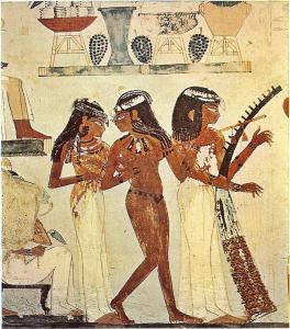
Among multiplied and various artifacts exposed there, I would like to pay your attention to one small and a very fragile object of the size of 20 x 15 cm. It’s a painting, or more precisely a drawing on a limestone ostracon representing an Egyptian young girl caught in an acrobatic position. An ostracon itself is a potsherd, usually used as a writing or painting surface. At that time it may have served as a scratchpad.
Ostracon showing a dancer in an acrobatic position. Limestone, New Kingdom, 19th-20th Dynasty (1292-1076 BC). Deir el-Medina. Drovetti collection (1824). Cat. 7052. Creative Commons (CC). Deir el-Medina. Drovetti collection (1824). Museum location: Sala 06 Vetrina 06. Cat. 7052 (2018).In: Egyptian Museum in Turin, Italy.
An Acrobatic Somersault
The object comes from the ancient Egyptian village, Deir el-Medina, dating back to the period of the New Kingdom (between 16th and the 11th century BC.). For over four centuries, Deir el-Medina had been home to highly skilled architects, temples and tombs builders, artists and various craftsmen staying in the service of the pharaoh. Thy lived there with their families but usually spent the entire week at work in the Valley of the Kings and Queens. A village artists must have been an author of the drawing probably representing one of girls living in the same community. Village women also served to the pharaoh but as dancers and singers in local temples. Egyptian Dancers played an important role in ancient Egypt. Not only was dancing a form of entertainment but it was mainly associated with religious ceremonies.
The depicted girl is a dancer. She is naked, except for a short black kilt with a decorative patterns on it and circular earrings of gold. The girl is probably performing an acrobatic somersault of a ritual dance. The artist is believed to have drawn first the body and then the head by rotation of the ostracon to a position where the profile could be done in the usual way. After a historian of art, William H. Peck, this way of making the drawing is suggested by the placement of the earring in defiance of the laws of gravity, and a rather unnatural way in which the neck was joined with the shoulders, with strongly elongated arms and legs. Also the shape of the dancer’s breast seemed to be sketched as if the artist imagined a woman’s torso in a standing position.
Egyptian style of art
Creating all the elements of the entire scene separately was very characteristic of Egyptian style of art.
The photo is showing dimensions of the object by means of a ruler, which is 11.5 x 17 x 4 cm. Deir el-Medina. Drovetti collection (1824). Cat. 7052. Creative Commons (CC). Deir el-Medina. Drovetti collection (1824). Museum location: Sala 06 Vetrina 06. Cat. 7052 (2018). In: Turin Museum, Italy.
It is like in a case of a child drawing an object without a three-dimensional perspective, but in a way the object is perceived from their position of watching, with its major characteristics. Looking down on a puddle, they can see its shape and what is inside, but when they observe a tree, they see it in its vertical form, and not from the above (which is not possible without flying over the trees!). Now they put all these observed elements together, on one piece of paper and they receive a similar stylistically incoherent whole, created once by ancient Egyptians.
Crescent of the Goddess Nut
Representation of the Woman Dancer seems slightly naive, yet it is very subtle and graceful in its form, depicted with a great skill and imagination. The artistic quality of the design is exceptional and erotically charged. The bare-breasted female is bending nearly over reaching the floor with her stretched arms and despite the drawing’ simplicity, the young woman seems extremely flexible. You may have an impression she has been caught in a nimble and swift dance at the sound of vibrant music.
The air god Shu, assisted by other gods, holds up Nut, the sky, as Geb, the earth, lies beneath. Detail from the Greenfield Papyrus (the Book of the Dead of Nesitanebtashru). Photograph published 1997; artwork created c. 950 BC. Photo source:What Life Was Like on the Banks of the Nile, edited by Denise Dersin.Photographed bythe British Museum; original artist unknown. Public domain. {{PD-US}}. In: Wikimedia Commons.
Her curly long hair touches the ground as her body is bending in a deep bow. As the author, Patrick Hunt has noticed, the Dancer’s pose looks like a reversal of the sky goddess Nut in her downward earth-nourishing bend. Nut connects the earth with the sky, and according to the Heliopolis beliefs, the goddess touches the ground only with the tips of her hands and fingers. Simultaneously, her body covered in stars takes the shape of a semi-circle, which immediately evokes a crescent and its associations with femininity.
Voices of Common Egyptians
Ancient Egyptian Music & Dance. Scene from Tomb of Nakht, 18th Dynasty, Western Thebes. Photo source: Carolinarh (2013). “Ancient Egyptian Tomb Art. Necropolis of Thebes” (unknown artist). In:Ars Artistic Adventure of Mankind. The History of Art through the millennia.
Female dancers are usually depicted on tomb walls and temple walls. They are represented nearly naked with golden belts around their waits and collars around their necks. They are wearing jangling bracelets on arms, big earrings, and wigs, unlike our Dancer from Deir el Medina who is represented with her natural hair. All of them are caught in various poses – in profile, in three-quarter profile and even en face, free from being frozen in a hieratic posture of the upper class. They seem simply comfortable and full of life.
I came across the drawing of a female dancer while I was studying for an exam in the first year of studies of History of Art. It caught my eye from the very first moment, maybe because it was not created for formal purposes but probably for pleasure or training as a sketch. I don’t know why an artist chose to draw a dancing woman but his work now can tell us a story about simple people who once lived in Egypt.
‘On the outskirts of Deir el-Medina, the villagers once had attempted to find a water source’, explains Joann Fletcher, an Egyptologist. ‘They dug down and eventually they reached more than fifty meters. They wanted to become self-sufficient in water but sadly for them they never did, and what the pit did become was a community dump, and as such became a mine of information. And when this pit and its surroundings were excavated by archaeologists, they made some remarkable discoveries, and the ostracon with the drawing was one of the findings among thousands of these pieces of pottery and stone: some with painted pictures, many with words giving us the real history of the village. These are their notes, reminders, love songs, laundry list, the very voices of common Egyptians.’
Featured image: Dancer, Deir el Medina. Ancient Egyptian depiction of topless dancer with elaborate hairstyle and hoop earrings in gymnastic backbend, on ostrakon (potsherd). Created: 1292-1186 BC. Public Public domain. Photo and caption source: “Dance in “Ancient Egypt” (2021). In: Wikipedia. The Free Encyclopedia.
After a week of travelling around Mexico, from Yucatan and Chiapas State, and through Tabasco to Oaxaca, I experienced a special magic and a variety of cultures of the country, felt by Mexicans and foreigners alike.
The state of Oaxaca is a mountainous area broken by wide fertile valleys and it represents one of the bastions of indigenous cultures having been developed for thousand of years in Mesoamerica. Apart from the country’s most energetic and colourful festivals, various arts, well-developed crafts, delicious cuisine and vibrant colonial architecture of the capital, the region also boasts a number of pre-Columbian sites and artefacts left behind by mysterious peoples.
There are around 4000 recorded archaeological sites in Oaxaca, mostly known as settlements of the Zapotecs and Mixtecs, occupied up until the Spanish conquest in the sixteenth century. The all sites differ in time and characteristics, however, all include a mystery: Lambityeco and Zaachila have got interesting tombs, Dainzú and Yagul – important ball game courts, and San José el Mogote is said to be one of the most ancient settlements in Oaxaca. Among all, though, Monte Álban and Mitla were two of the most important.
‘Place of the Rest’
Mitla is located about an hour drive from Oaxaca City and it was presumably the main religious center of the region. The name Mitla itself comes from the word Mictlan, the name for the ‘underworld’ or the ‘place of rest’ in Zapotec, the language which is still relatively widely spoken, especially in villages. The walls at Mitla are covered with spectacular geometric mosaics which are unique in Mexico, as much as its bright red painted walls. We stopped there on our way to Oaxaca City, driving along the range of Sierra Madre mountains. It was around 3 PM and a blast of hot air struck me full when I was getting off the air conditioned car.
The site looked amazing with geometrically designed upper parts of the buildings, covered in intricate mortar-less mosaics. My attention was also caught by walls painted bright red. Once Mitla was inhabited by the people, called by the neighbouring Aztecs in Nahuatl – the Zapotecs. Yet they called themselves differently, either simply The People in their own language or more mysteriously – the Cloud People.
Just in in the heart of Oaxaca state, along the western coast of the Pacific Ocean, which is at once a mountainous and hard-to-reach area, the Zapotec culture probably began to take shape around the third century AD. Some scholars assume that the Zapotecs had already appeared when the Olmec civilization was on the verge of decline, that is presumably around 400 BC. and existed in the region till 1500 AD. Anyway, any exact dating is uncertain here; the Zapotecs probably came to modern Oaxaca areas in the period before Christ, yet it took several centuries for them to develop their characteristic cultural features, which were initially composed of mixed elements of various origins, from Teotihuacan and the Olmec to the Maya cultures. At the Zapotecs’ height, the population in the Valley of Oaxaca peaked at around one hundred thousand.
The ruins of Mitla are the quintessence of the Zapotec architecture. Yet, the city also witnessed the Zapotec-Mixtec symbiosis, which had been visible in the culture of this region since the fourteenth century AD. Its traces can be seen especially in Mitla, whose geometric motifs of mosaic fretwork cut in stone slabs are usually ascribed to the Mixtecs. Yet, another theory says the ornaments were made my the Zapotecs and then adopted and embellished by the Mixtecs. Such patterns are called grecas in Spanish; meanders, diamonds, zigzags and various braids cover not only the outer walls of significant buildings, but also their interiors, usually with three horizontal stripes of frieze, each with a different type of ornament.
It has been calculated that over eighty thousand polished stone slabs were used to adorn the walls in such geometric friezes. The [stones] are [all] fitted together without mortar; [all the] pieces were set against a stucco background painted red [and] are held in place by the weight of the stones [surrounding] them. […] None of the fretwork designs is repeated exactly anywhere in the complex [or elsewhere] in Mesoamerica” (Mitla” 2021). In the wall painting, frescoes and sgraffito made on red stucco, depicting deities and mythological animals, there are also many Mixtec motifs, which are younger than sculpted decorations.
As in the case of the Zapotecs, little is known about the Mixtecs; they are primarily famous as great craftsmen and artists. The Mixtec contributed to the culture of the region, especially in the field of goldsmithing; they were excellent at processing gold, copper and silver, they mastered lost-wax technique, they could solder and pull delicate wires. They knew the inlay and covered the wood or bone with small tiles of jade or turquoise, mother of pearl and rock crystal. The Mixtecs were also the authors of famous painted codices, mainly of historical content. Those were pictorial stories written or actually painted on long strips of wood-fiber or leather paper, created before the Spanish invasion, and also after it. Most of them, however, were unfortunately destroyed by the invaders.
The labyrinth of the Zapotecs and Mixtecs
The Zapotecs were called the ‘nation of builders’, however, if alternative researchers’ opinion is taken into consideration, most of the buildings of another famous city, Monte Alban (the original name of the city is unknown), and some structures of the nearby Mitla would rather be the product of older civilizations with great skills of shaping architectural space. Such structures, adopted or overbuilt by the Zapotecs would have originally provided a proper background for religious ceremonies or for other purposes, most likely related to astronomy.
In Mitla, there are three groups of buildings situated at low platforms and concentrated around a ceremonial courtyard, to which extensive stairs still lead. One of the most impressive constructions of Mitla is a ‘palace’ dating from the twelfth to the thirteenth century; it has three square, interconnecting courtyards, rebuilt with buildings standing on low platforms. In the ‘residential’ part of the city, there is a very small courtyard surrounded by four shallow buildings. The inner galleries must have been exceptionally dark, covered with low wooden roofs.
The rooms around the second courtyard may have served official functions. They gained their size thanks to the alignment of monolithic columns supporting the ceiling beams. Under the rooms of the third complex, which was probably used for religious ceremonies, there are cross-shaped crypts. These crypts are a continuation of the development of the Zapotec tombs, initiated in Monte Alban, where the niches had already been shaped like a cross. The walls and floors of the crypts were covered with a thick layer of white plaster, on the smooth surface of which cult scenes were painted. Such decorations are later than architecture and were probably made by artists of the Mixtecs who lived in Mitla after the Zapotecs left. Endless halls, corridors and underground crypts criss-cross beneath the central plaza, giving the impression of a labyrinth whose architectural character resembles the so-called palace of Knossos in Crete. Possibly, hence, the city’s name standing for the underworld.
The residence of the high priest in Mitla was the largest covered structure not only in Mitla but also in Pre-Columbian Mexico. The unpreserved ceilings, probably wooden, were supported by massive monolithic pillars weighing up to twenty-three tons. The decoration of walls with strongly marked horizontal divisions is primarily made of the mentioned above geometric ornament.
Missing stone anomaly
We were standing in the middle of a great courtyard when an old man with a walking stick approached us. He looked a little tired with the heat but his face expression was revealing his passion for the site and his happiness to share it with us. He was an experienced archaeologist working in Mitla for years and he seemed to know every excavated corner of it.
He spoke only in Spanish to us gesticulating energetically with hands, surely to express his ideas more clearly. Soon, we started following him up and down the stairs leading to Mitla’s constructions one after the other, to take a closer look on elaborate patterns of the mosaics. Despite our guide’s difficulties with walking, he and his staff were much quicker than us in climbing the steep and narrow steps.
‘Oh, you see … each course of stones is composed of a certain number of stone elements’, he said once on top, while counting every element protruding from the wall and composing a particular pattern of the mosaic.
‘Here, they made a mistake!’, he noticed, eager to show us his discovery.
At once, all started counting other stones in hope, they would find another anomaly as well.
Who was there first … ?
I left my friends at this stage of competition and went exploring the site on my own. I noticed a few tall basalt columns between two to three metres high as well as the size of giant cut blocks on top of the walls, forming the so-called lintels, weighing from six to eighteen tons, whereas elsewhere within the same construction there was relatively crude work composed of much smaller irregular stones of different shapes with big amount of mortar used. When we compare both, the latter looked like common rubble.
I got an impression that different parts of constructions had been here reassembled. Accordingly, there are differences in construction style: here and there very large, regular tight-fitting stone slabs at the base, and massive header blocks made of basalt, now and then perfectly positioned down at the foundation with quite crude and rough work in between. The same feature is typical of many megalithic sites not only in Mexico but also in different parts of the world I have visited. After some alternative researchers, such as Brien Foerster (2018), Mitla had been constructed first with megaliths, and then it was uncovered by the Zapotecs, who adopted the older structures and overbuilt the site using their own but much simpler techniques within their building possibilities. The same author suggests that it might have been the result of some sort of a cataclysm that destroyed the original buildings of high technology a long time ago before the Zapotecs occupied it, followed then by the Mixtecs. To go further, the basalt of Mitla had been quarried from the place which is over three kilometres away (with no trees to be used as log rollers).
In the depths of the complex of Mitla, red domes of the Baroque Catholic church of San Pedro are visible; its walls seem triumphant over the Pre-Columbian ruins, but perfectly integrated into the whole ancient landscape. The church was built in the colonial era by Spanish invaders surely to show their victory over the pagan cultures of Mesoamerica. Nevertheless, the building was partially composed of the already cut stones that were found by the Spanish locally, and reused for its construction.
Eventually, I did not share my thoughts about previous lost builders with others. Such assumptions may have been too controversial for academics’ ears and I was sure what their response would be like. Anyway, all these building anomalies can be seen very easily, still only if one does not turn a blind eye to the architectural facts.
By Joanna Faculties of English Philology, History of Art and Archaeology. University of Silesia in Katowice, Poland; Cardinal Stefan Wyszyński University in Warsaw, Poland; University College Dublin, Ireland.
Summer weather was at its best while we were driving south along the Ring of Kerry, which is also a stage of the famous Wild Atlantic Way with sea-salted shores and blowing winds.
The scenery was breath-taking – it was like stepping into a picture book. Our destination, the Skellig Islands, lie 12 km off the Kerry coast and the boats there depart from Portmagee and Ballinskelligs. The Islands are actually two very steep rocks, protruding proudly out of the wild roaring Atlantic. Skellig Michael, which peaks at 217 metres above sea level, was the home of a group of 13 monks in the sixth century AD. This monastic settlement became then designated as a UNESCO World Heritage site in 1996. The smaller island, Little Skellig, which is a haven to various seabirds, has the second largest gannet colony in the world.
“You can do Ireland in a day, but you really only do Valentia properly in a lifetime”[1]
[1] Karen O’Connell (2018). “Explore Valentia”. In: Valentia Island. Come on in. Valentia Island Development Company.
We had booked our B&B on Valentia Island – one of Ireland’s most picturesque westerly points. It lies off the Iveragh Peninsula in the southwest of County Kerry and is accessible either by the Maurice O’Neill Memorial Bridge from Portmagee and by car ferry from Renard Point, Cahersiveen, which operates from April to October. The ferry crossing takes around 5 minutes. After a night-sea journey from Wales, and having travelled across a large piece of Ireland, from Rosslare, we felt only like going to bed. B&B (like the very few houses scattered around the island) was an isolated and charming place of the home-stay atmosphere of remote villages.
Out of reach …
We were planning to take our Skellig Michael landing tour in one day and I was praying just for god weather conditions as the landing on the rock is always subject to this natural factor and the Irish weather is really unpredictable… We arrived in Ireland at the end of July having had the visit booked already at the beginning of May, as one must do it much in advance before heading off to the Skelligs. It was in 2015, just before the Star Wars’ Episode VIII was filmed at its top and Luke Skywalker won its place on the island, removing its real and fascinating characters in the shadow. Due to that, nowadays it is even more difficult to land on the island as there are hordes of Star Wars’ fans and thus government restrictions are applied now more than ever, not to mention a very high price for this major tourist attraction that could be the highlight of every holiday.
First of all, tours with landing can only be taken from May to September. All bookings are usually taken online with no waiting list. If there is a cancellation the spots automatically become available again on the booking page, which happens very rarely. There is one trip per day for this tour departing at approximately 9:00 am daily, usually from Portmagee Marina (depending on the tour operator) if the sea and weather conditions are suitable. As I have mentioned, availability for this tour is very limited so you really need to book well, well, well long … in advance: there is a maximum of four persons per booking and the tour itself is not suitable for children under 12 years of age.
When I am looking at the availability now, I can see the whole season is nearly booked out (there is only one date available!) Also you would require a reasonable amount of fitness to undertake climbing the rock at its summit. In case your boat tour is cancelled, you can take instead a tour around two islands but without landing …
In the morning of the tour day, our B&B’s hostess welcomed us with a wide smile assuring us the boats were going to departure. I also responded with a beaming smile and came back to my full Irish breakfast composed of crumbled eggs, fried sausages, crunchy toasts and milky butter. I had already phoned my tour operator and he assured me the weather would be perfect for our journey.
‘Would you like some pudding?’, – the hostess asked. ‘I’ve got delicious black and white pudding if you wish’.
‘I’d love to’ – my friend said in Polish – ‘I feel like having something sweet …’
Pudding is a type of food that can be either a dessert or a savoury dish, which comes from French boudin, meaning ‘small sausage’. My friend who shudders at any kind of red meat definitely was for the first option, whereas the hostess had meant the second one. When my friend finally found out, she refused point-blank to try anything of that kind.
Off we go …
Good walking shoes, mostly hiking boots with an ankle support, and waterproof clothes are essential for the tour! The boats are small fishing vessels and the open sea crossing takes approximately 45 minutes.
Office of Public Works (2014). “Visiting Skellig Michael – A Safety Guide”. Source: Youtube.
Rough seas make you get soaked to the skin, even if a day is full of sunshine. The boats are being constantly hit by high waves and so it’s quite unstable as the boats are rocking all the time. Hence it may be a very difficult experience for people who are prone to seasickness. The site is also difficult to walk around, as well as may pose problems for anyone with a fear of heights. There are no visitors’ facilities of any kind on the island, such as toilets or a shelter. This is a bare and high rock exposed to the weather. Make sure you bring with you enough food and water. All your stuff should be packed in one small backpack to allow your hands to be free while climbing up and down the steep staircases.
A camera should be with you but only hung around your neck. Sun cream is also very important. Even if the sky seems cloudy, there’s enough sunlight reflecting from the water to cause sunburns. While our cruise to the Skelligs, the sky was completely covered in grey clouds. On the island there was already the sun and on our way back I got a strong sunburn on my face. After drinking a pint of Guinness in the end, my face looked like a red berry on the background of green Ireland. Well, it’s not to discourage you, just let you know what you can expect … One more thing! Once landed on the island beware of seagulls and albatross hunting for meal! It can be your sandwich or a cookie you have just grabbed in your mouth … You may have a literally close encounter with a huge bird flying onto your face. As I did myself!
Without a doubt, one of the most graceful and friendliest bird visiting the Skelligs is a puffin. They arrive and breed on the island from March to early August. It’s a cute, colourful seabird with a huge, yellow-reddish beak and curious eyes. While the birds are walking around, they look like black-white balls rolling down the hill. It’s really worth seeing!
Just before our heading off, there was a warm shower. I sat by the side of my friends, back to other people. We were eight altogether, not counting two men, probably fishermen driving the boat. Although it was a rather wet and rough journey, I really enjoyed it. This is one of these moments you may really feel a unique atmosphere of ancient Ireland. We were on the open sea and our crossing seemed to go on forever. I also thought about ancient monks and pilgrims who must have made just the same distance in simple boats – coracles, and without modern navigation devices down the centuries. I wondered how many of them had survived.
The Loneliest Place on Earth
Two black pinnacles of pointed rocks thrust out into the Atlantic Ocean. The smaller of these two is known as Lesser Skellig, which is home to a great number of gannets, and grey seals lying airily on their backs and enjoying the warmth of the summer sun. Visitors cannot land on it as it is the birds’ reservation. The larger island and our destination is called Great Skellig or Skellig Michael. The latter name probably originates from a legend saying that St. Patrick once saw the Archangel Michael hovering over the island. Here, in the wilderness of the Atlantic Ocean and isolated from the comfort of the mainland, early Christian hermits lived for centuries fighting with natural forces and invaders coming from the sea – the Vikings.
Peter Cox (Photography) (2017) “The Wonder of Skellig Michael”. Source: Youtube.
Their harsh life many a time is similar led by Christian monks in Egypt who started this kind of an isolated existence, dedicated to God – monasticism. I believe that in their desire to imitate the lives of the Egyptian Fathers, Irish monks found their substitute for the desert in the sea and ocean. On numerous islands like Aran, Inishkea North, Duvillan, Iona, or Skellig Michael, Christian Celtic monks were looking for their own desert. Just like an Egyptian desert of the Coptic hermits, an ocean is huge, desolated and deprived of sweet water. On the other side, it must have seemed attractive, unknown, inhabited by fantastic monsters, and so became an escape from the earthly world. The ocean has been a symbol of trial, weakness, heroism, and as in the unfriendly desert, the help of God becomes indispensable there.
The waters were calm on the open sea but as we were getting closer to the rising pyramid of the rock, the waves became stronger fiercely crushing against the shore. Our drives moored the boat properly and we carefully climbed out of it. The rock-solid land beneath my feet seemed to jump up and down as much as our boat. I looked upwards at this soaring rocky sanctuary covered in a green coat, and I could just felt the loneliness of this place fulfilled with the ghosts of the wandering monks.
Soon we reached the staircase of ancient rock-cut steps made by the hermits and polished by countless pilgrims’ feet. There are over 600 uneven and steep stairs leading up to the monastery. I felt my great respect for the monks who chose this remote island for their home. It called for extraordinary self-discipline and great courage. As modern pilgrims, we entered into the monks’ enclosure almost suspended in the sky. The views were stunning!
We passed through a low archway breaking the silence of the past. A small monastic garden sheltered around with rough stones. Another archway led us higher to the tiny chapel and a cluster of dry-stone beehive huts look like bulbs or swallows’ nests clinging to the rock. These extraordinary shelters are circular from the outside but square in the inside. Perhaps the hermitage on the Skellig has preserved the original pattern of monastic buildings, existing once at monastic sites on the mainland. The beehive huts resemble the stle of stone constructions of the neolithic period typical to insular tradition.
However, after some researchers, the shape of these monastic structures was reminiscent of the monastic areas in Egypt. Desert fathers built similar huts in the shape of bee hives, most often from silt, initially in isolation, later probably in order to provide themselves with greater security and mutual support, they began to gather in small communities, putting together a number of such structures. Before the belly-like huts became the home of the hermits, they had been first simple houses. Similar constructions are traditional for the desert regions of the Middle East and for millennia they have been used as such by the rural community, such as by one in the territories of today’s Syria, in the town of Sarouj.
There are dry-stone cells, a square oratory, a church dedicated to St. Michael, two small wells for collecting fresh water, and a miniature graveyard of those who lived and died on the island. I learnt that there were apparently thirteenth hermits occupying the monastic sites, which is a symbolical number that stands for twelve apostles led by Jesus Christ. One legend – a treasury of knowledge on the past – ascribes the founding of the monastery to St. Fionan in the sixth century. Still the first historical reference goes back to the fifth century and says of the King of West Munster being pursued by Oengus, King of Cashel. The former fled to Scellec (Sceillic), which means a steep rock. Hence the name f the islands. In the following years, there were three recorded attacks on the monastery by the Vikings who put many monks to death. During one of them, the Abbot, called Eitgall was chained up and starved to death to amuse his captors. Some monks escaped slaughter by hiding in rocky crevices, still they were left on the rock without their coracles burnt by the leaving Vikings.
To my surprise, one story says that King Olaf Tryggvason of Norway met there a hermit who impressed him so much that he became baptized. After his return to Scandinavia, he is said to have introduced Christianity there before he died in the year 1000 AD. The Skellig monastery had greatly flourished since the sixth century and lasted famous till the twelfth century, when the Celtic Church was overtaken by the Church in Rome and the meaning of monasticism started long ago by Coptic hermits ceased. What is more, around 1200 AD, the climate had changed. Cold weather and fierce storms made the island even more inhospitable than before. As a result the monks moved to Ballinskelligs Bay on the mainland leaving behind their desolate rock.
It was not until the late tenth century or early eleventh as the monastery is first referred to as Skellig Michael in the Annals of the Kingdom of Ireland by the Four Masters. Probably, the small church dedicated to St Michael was built at that time. Its architecture is thus different from the earlier dry-stone constructions built by the monks. It is believed to have had a hollow stone of miraculous properties fixed to its wall. Some scholars consider the Libellus de Fundacione Ecclesie Consecrati Petri from the mid thirteenth century to be one of the most important written sources on Skellig Michael. The manuscript originates from the Consecratus Petrus, an Irish Monastery in Regensburg, in Bavaria. Since the seventh century on, the Irish monks had been travelling to the mainland, founded monastic sites and preached … but it is another story … Anyway, the manuscript reveals a tale from Irish Monks in medieval Germany. It provides a context for its dedication to Archangel Michael.
As the story goes Ireland suffered under a plague of demons, dragons, serpents and toads. People called upon St Patrick who banished the demons to the highest mountain (Skellig), cutting off all access for safety. Still, the evil was still present there. St Patrick then raised his arms in invocation and suddenly, the skies illuminated. Out in the Ocean, on top of Great Skellig, stood Archangel Michael with the host of angels surrounding him. Angelic forces battled with the demons and eventually cast them into the Ocean. Eventually, the angels returned to Great Skellig, and from the peak, Archangel Michael ascended back to heaven, leaving his miracle-working shield behind.
It was the early Christian age of Skellig. The pagan one is even more hidden in the misty legends of Irish history. Unfortunately, such records are usually treated as purely mythical, without historical value. According to them, the fabled rulers of Ireland – Tuatha de Danaan, once used their magical powers to overcome new invaders (1400 BC). They caused a shipwreck and brought death to two sons of the invaders’ leader – Milesius. Skellig became a burial place to one of the brothers, who was called Irr. Another legendary visitor was Daire Domhain – the King of the World, who stayed on Skellig in around 200 AD before attacking the mainland. Irish stories are full of legends of old and new invaders, of victors and defeated.
Skellig Michael is the last of three islands dedicated to St Michael I have seen. All of them lie on the same invisible path, aligned to the direction of 60 degrees NW-SE. The so-called Apollo/St Michael Axis stretches further south-east to run not only across the tree islands but also two Archangel’s monasteries suspended high in the mountains, and finally reaches the sites in Greece, dedicated to Apollo, the pagan counterpart of Archangel Michael.
By Joanna Faculties of English Philology, History of Art and Archaeology. University of Silesia in Katowice, Poland; Ecole France Langue, Paris; Cardinal Stefan Wyszyński University in Warsaw, Poland; University College Dublin, Ireland.
The megalithic temples of Malta are one of the most recognized UNESCO’s World Heritage sites ranking amongst the earliest free-standing Neolithic constructions in the world. The so-called Maltese temples display unique developmental characteristics, and while comparing to other megalithic structures, they are of the distinctive nature and achievements of Maltese civilization.
On the other hand, similarly to other megaliths, they were undoubtedly designed to accurately detect and mark the winter and summer solstice together with autumn and spring equinoxes, and other celestial movements. Same as the Stonehenge circle in Britain and Newgrange in Ireland, Maltese temples fulfilled astronomical observation and calendric functions. Among their other possible functions, a connection between astronomy and the temples orientations has constantly been provoking an intense debate since the great publicity given in the second half of the twentieth century by Gerald Hawkins on Stonehenge and the surveys by Alexander Thom on different megalithic structures in England and elsewhere. But it was an astronomer, Sir Norman Lockyer who as early as in 1909 evidently stated that Newgrange is oriented to the winter solstice. Accepting that idea turned out to be difficult for archaeology as it was first presented in the form of folklore and legends in the seventeenth century. In spite of negative opinions of the foremost experts on megalithic structures, interdisciplinary research efforts on the subject have been carried out and quickly augmented, mainly in the study of archeoastronomy, cosmology and archaeology.
Maltese Temples and the Sky
The book by Tore Lomsdalen, entitled Sky and Purpose in Prehistoric Malta: Sun, Moon, and Stars at the Temples of Mnajdra (2014) is the latest attempt to resolve the two-century controversy over the unusual connection between the Maltese temples and the sky. At the same time, it successfully elaborates on the first tentative surveys on temple orientations in Malta. This remarkable work charts the major points of debate on astronomical alignments of the prehistoric megaliths of Maltese archipelago with a special focus on the question of the intentionality of the significant orientation of the Mnajdra Lower or South Temple. The overall conclusions found at the end of the book are thoroughly investigated and supported with accurate factual information drawn from both, the previous interdisciplinary studies on the subject, and results of the wide-ranging and detailed fieldwork done by the author on the sites. Simultaneously, the book contributes to the international research done on the astral connections of megalithic constrictions in different parts of the world, underlying their similarities and uniqueness at the same time.
The author of the book, Tore Lomsdalen is an astrologer working internationally. He was born in Norway and lived in Italy. He holds a MA in Cultural Astronomy and Astrology from the University of Wales Trinity Saint David and a certificate from the Faculty of Astrological Studies in London. While working on the mentioned work, he had already been engaged in a PhD research program with University of Malta on Cosmology in Prehistoric Malta. Through a combination of astronomical analyses and insightful interpretation of the enigmatic ancient monuments, he entirely dedicates himself to the studies on cosmological observations related to Maltese prehistoric sites. He understands the need for revisions in the context of interdisciplinary studies, where the discipline of archeoastronomy blends with the study of archaeology, and specifically prehistory. As he frequently points out in his book, archeoastronomy may contribute to archaeological examination, especially in the reconstructions of the building phases in case of the Mnajdra South.
Similar attitude has been already underlined by Martin Brennan, an Irish-American author who, like Tore Lomsdalen, perceives megalithic monuments as sophisticated calendar devices having been designed by contemporary engineers in order to reflect the sky. Martin Brennan majored in visual communication at the Pratt Institute in Brooklyn and studied prehistoric art in Mexico. As Lomsdalen, he was engaged in a series of fieldwork where he gathered overwhelming evidence for his theory which was at that time quite controversial.
Martin challenges conventional opinions on presumed purposes of megaliths as tombs and proves their high sophisticated orientation in relation to astronomy. In his book, The Stones of Time. Calendars, Sundials, and Stone Chambers of Ancient Ireland, (1980s) Brennan interprets the real function of Newgrange by means of the unified languages of archaeology, archeoastronomy, architecture and art. That interdisciplinary unity of sciences can be deeply felt when the rising or setting sunlight is being caught by inner chambers of passage tombs at critical times of the year, illuminating only particular patterns among many other engraved on the stone. In such a way abstract symbols, which were thought to have appeared haphazardly, suddenly became the key to the enigmatic language of prehistory connecting with the stars.
Megalithic Art
Although Brennan underlines the importance of megalithic art as a crucial element in relations to astronomical calendar, for Lomsdalen it does not play a vital role. Likewise Brennan, he also points out to architectural areas of the temples illuminated by the sun, such as key thresholds of the side altars and the vertical slabs, yet without elaborated descriptions of artistic decorations of the temples. Lomsdalen realises the significance of the perceivable effect of dichotomy of light and dark created by sunrise illuminations. However, he mostly focuses on his archeoastronomical survey and ably presents the results of his fieldwork juggling with astronomical complex calculations, with particular attention to the alignments of the Mnajdra Temple complex. Lomsdalen also places the Maltese structures in their archaeological context redefining their building sequence, still without clearly stating their purpose in prehistory, as Brennan does while relating to the passage tombs as megalithic observatories. In the matter of fact, Martin Brennan completely rejects the idea that Newgrange and other similar constructions were built as burials and argues that originally they served as astronomical devices.
Undeniably, one of the aims of Lomsdalen’s work is an investigation whether the Mnajdra Temple complex was built as a sacred site in relation to the cosmos, and as a device for celebrating the seasons, but none the less, that research question is a secondary in the conclusions of his book. His major concern is the intentionality behind the astronomical alignments of the Mnajdra Temple complex, which is in turn, the precondition of the hypothesis of religious, sacral and ritual character of the so-called temples. The author’s argument for intentionality is strengthened by the fact that astronomical orientations appeared in the Mnajdra complex throughout successive stages of its construction. In this case, all the claims against his postulate lose substance. The idea of intentionality in prehistoric architecture is also strongly supported by Martin Brennan in case of passage tombs in Ireland. He argues that such precise positioning of stones in an astronomically important context cannot be just coincidental. Both researchers additionally employ similar methodology in their fieldwork. Besides surveying, astronomical observations, and photography, they implement principles of experimental archaeology, or rather archeoastronomy, which involves testing a hypothesis through experiment in order to find evidence of ancient astronomy, apparently practiced by temple builders. Phenomenology, that is to say walking and experiencing the landscape, is another approach to their research.
Final results of Tore Lomsdalen’s report show new evidence about the architecture of Maltese temples and their link with the sky. Namely, the author confirms the hypothesis of a sky-based intentionality behind the construction of the Mnajdra Temple complex. Not only confirms he the known alignments at the Mnajdra South but also discovers new alignments at the Mnajdra Middle. Furthermore, there is a strong preference of the temples being directed between southeast and southwest, with one remarkable exception of the Mnajdra South or Lower facing east allowing the rising sun to cast a beam of light along its central axis at the equinoxes and cross-jamb illuminations at the solstices. The Temple’s sophisticated solar illuminations is explained by an increasing awareness by its creators of horizon-based astronomy and their better understanding of precise divisions of a solar year, including cross-quarter and the eighth days. The so-called oracle holes in the stones and postholes have also been investigated as supposed devises playing a significant role in aligning the temples to celestial bodies. Finally, the author proposes a redefined building sequence based on both archaeological finds and archaeoastronomical components. He strongly claims that the Mnajdra Temple complex was not built at once but in five successive stages: double apses and other architectural features had been added on for one and half millennia.
Mnajdra Temple Complex
Before moving directly to the matter of his studies, in the first chapter the author starts with a description of the temple culture within a sacred, cosmological, and astronomical context and uncovers “perhaps the best-kept secret in Mediterranean archaeology” in relation to the megalithic constructions on Malta. In Chapter 2 and 3 he introduces readers to the rich Maltese prehistory within the context of the Mediterranean, which is a very important background of the Neolithic temples. He also gives some speculative ideas about the origins of the temples and their mysterious creators. At this stage, he provides a detailed description of the Mnajdra Temple Complex. He stresses the importance of Maltese landscape and its influence on the carefully chosen location of the temple sites. Quite significant for the author is also their relations to land and sea, as in the case of the Mnajdra Temple East – the only one in Malta lacking an orientation towards sunrise, but oriented, and so apparently connected to Filfla islet. Next chapter moves smoothly to the core of the subject, from Maltese cosmology and astronomy in the context of the temple culture to methodology used in this work.
Lomsdalen, T. (2014) “Mnajdra was not built in a day.” Accessed on 17th of July, 2018, on Youtube Channel by Tore Lomsdalen.
In Chapter 5 the author presents the results of his fieldwork in Malta, particularly at the Mnajdra site, and subsequently compare them to other researchers’ findings. After all the results being discussed, Lomsdalen finishes his study with a summary and conclusions of the major findings regarding his hypotheses brought by and cited before. Simultaneously, the author highlights the need for further studies to be conducted, especially in searching for archaeological evidence on the chronological phases of temple construction.
Language of Astronomy
The amount of data gathered, survey measurements and a frequent use of the language of astronomy is impressive from one side, but from the other, it may be confusing to average readers not trained in astronomy. Nevertheless, the author helps a reader to understand a more scientific content by providing an approachable description of some definitions, such as the key difference between “orientation” and “alignment”. Additionally, there is a number of technical drawings and diagrams in order to illustrate the issues being dealt by the author during his studies.
What is more, at the end of the book readers can find a glossary and acronyms of temple orientations in Appendix IV, a detailed bibliography for reference, and very interesting discussions of the author with other researchers in Malta, Frank Ventura and Reuben Grima talking on different aspects of the megalithic temple culture. The book is also beautifully illustrated by series of photographs, including archival black-and-white photos from the nineteenth century and colourful pictures taken by the author himself. In general, it is a really comprehensive, consistent work and a very valuable complement to the study of both, archeoastronomy and archaeology. Additionally, Tore Lomsdalen’s innovative idea of dividing the construction of Mnajdra Temple complex into five sequences according to the temples’ alignments with the sun may be carried out at various megalithic sites scattered all over the world, where archeoastronomy together with archaeology can assist in determining successive phases of prehistoric constructions.
[1] An advertising slogan accompanying the painting of Saint Anne and promoting Faras Gallery at the National Museum in Warsaw.
Go, ye swift messengers, to a nation scattered and peeled, to a people terrible from their beginning hitherto; a nation meted out and trodden down, whose land the rivers have spoiled!
Saint Anne is a Nubian wall painting estimated to have been painted between the 8th and 9th centuries, by using the technique al secco with tempera on plaster. This early Christian painting was discovered by a Polish archaeological team led by the Professor Kazimierz Michałowski during a campaign undertaken in the 1960s under the patronage of UNESCO (the Nubian Campaign) in Faras. The image itself belongs to a unique collection of wall paintings and architectural elements from the Faras Cathedral, discovered by an archeological mission. Faras Gallery is the only permanent exhibition in Europe featuring Medieval Nubian paintings from the Nile River Valley south of the First Cataract. The collection of over 60 paintings from the 8th to 14th centuries came from the cathedral in the city of Faras, a large urban centre in the Medieval kingdom of Nobadia, in present-day Sudan.
Nobadian rulers controlling the Nile Valley from the first to the third cataracts converted to Christianity around 548 AD influenced by missionaries sent from Constantinople by the Empress Theodora.
The first cathedral was erected in the 7th century, when the city was still known as Pachoras, and likely stood at the exact site where Polish archaeologists taking part in the Nubia Campaign discovered the subsequent 8th century cathedral. The Nubia Campaign was an extensive international mission to preserve ancient legacies threatened by flooding from the imminent construction of the Aswan High Dam in Egypt and the resulting formation of the artificial reservoir, Lake Nasser. Since 1964 the painting is in the collection of the National Museum in Warsaw, of which the image has been used as a logo.
Saint Anne, of David’s house and line, was the mother of Mary and grandmother of Jesus according to apocryphal Christian tradition. Mary’s mother is not named in the canonical gospels. In writing, Anne’s name and that of her husband Joachim come only from New Testament apocrypha, of which the Gospel of James (written perhaps around 150 AD) seems to be the earliest that mentions them. In the painting, St Anne places her finger against her mouth, asking for silence, which may allude to the ‘divine silence’. The finger on the mouth could also indicate that the saint is praying.
Restoration work on the paintings from Faras at the National Museum in Warsaw. Dewaxing the surface of the painting depicting Bishop Petros with Saint Peter the Apostle, and applying compresses in 1960s. Published by National Museum of Warsaw (2016). Public domain (image modified). Source: Wikipedia (2020).
This gesture is rarely visible in Christian art and probably it refers to the tradition of Egyptian Christians (the Copts) who did so while praying undertone. It was believed to ward off evil powers trying to break into a human heart. Personally, I also understand this gesture as a synonym of a mystery and unuttered truth, which remains in silence. Also it is likely that Nubian women, similar to all women in the Christian world, directed their prayers towards St Anne requesting a child and a successful labour.


![Saint Anne of Nubia – “It Will Make You Specheless.”[1]](https://i0.wp.com/archaeotravel.eu/wp-content/uploads/2018/06/St-Annas-Fresco.jpg?resize=672%2C372&ssl=1)


